C. Density Determination for Option 1 and 2 Subdivisions
Applicants shall have the choice of two methods of determining the maximum permitted residential building density on their properties. They are as follows:
1. Adjusted Tract Acreage Approach: Determination of the maximum number of permitted dwelling units on any given property shall be based upon the Adjusted Tract Acreage of the site. The Adjusted Tract Acreage shall be determined by multiplying the acreage classified as being in the categories of constrained land (described below) by the numerical "density factor, for that category of constrained land.
a. The following areas of constrained land shall be deducted from the total (gross) tract area:
1. All land within the rights-of-way of existing streets or highways, or within the rights-of-way for
2. existing overhead rights-of-way of utility lines: and all land under existing private streets.
3. Wetlands: multiply the acreage of designated wetlands by 0.95.
4. Floodway: multiply the acreage within the floodway by 1.0
5. Floodplains: multiply the non-wetland portion of the 100-year floodplain by 1.00.
6. Steep Slopes: multiply the acreage of land with natural ground slopes exceeding 20 percent by 0.45.
7 Moderately Steep Slopes: multiply the acreage of land with natural ground slopes of between 12 and 20 percent by 0.30.
8 Extensive Rock Outcroppings: multiply the total area of rock outcrops and boulder-fields more than 1,000 square feet by 0.90.
b. If a portion of the tract is underlain by more than one natural feature subject to a deduction from the total tract acreage, that acreage shall be subject to the most restrictive deduction only.
c. Since acreage that is contained within the public or private rights-of-way, access casements or access strips is excluded from developable lot area, any portion of these items that also contains a natural feature subject to a deduction from the total tract acreage should not be included when calculating the adjusted tract acreage.
2. Yield Plan Approach: Determination of density, or maximum number of permitted dwelling units, shall be based upon density factor of the chosen option applied to the gross tract acreage, as demonstrated by an actual Yield Plan. Yield Plans shall meet the following requirements:
a. Yield Plans must be prepared as conceptual layout plans in accordance with the standards of the Subdivision and Land Development Ordinance, containing proposed lots, streets, rights-of-way, and other pertinent features. It must be drawn to scale, and it must be based on a field survey. Yield Plans must exhibit a realistic layout reflecting a development pattern that could reasonably be expected to be implemented, taking into account the presence of wetlands, floodplains, steep slopes, existing easements or encumbrances and, if unsewered, the suitability of soils for subsurface sewage disposal. Yield Plans should also reflect the dimensional standards for lots containing at least:
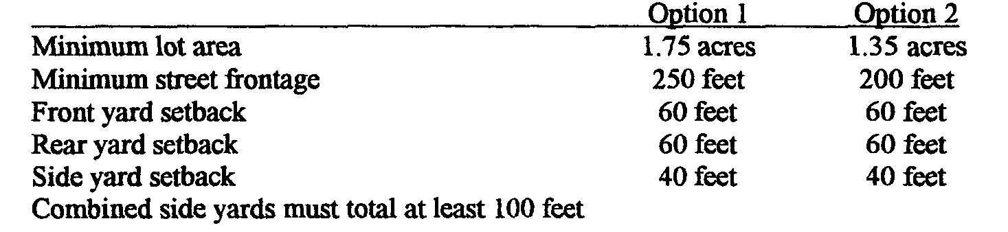
1.75 acres net lot average (Adjusted Tract Acreage) when Option 1 is chosen,
1.35 acres net lot average (Adjusted Tract Acreage) when Option 2 is chosen,
1.30 acres net lot average (Adjusted Tract Acreage) when Option 5 or 6 is chosen.
The density bonuses for subdivisions designed according to Option 2 (15%) and Option 5 or 6 (40%) shall be based on the number of lots produced on the Yield Plan at the lot sizes listed in the preceding sentence. The Yield Plan must identify the site's primary and secondary resources, as identified in the Existing Resources/Site Analysis Map, and must demonstrate that the primary resources could be successfully absorbed in the development process without disturbance, by allocating this area to proposed single-family dwelling lots which conform to the density factor of the chosen option.
On sites not served by central sewage disposal, density shall be further determined by evaluating the number of lots that could be supported by individual septic systems. Based on the primary and secondary resources, identified as part of the inventory and analysis, and observations made during an on-site visit of the property, the Planning Commission shall select a fifteen (I 5) percent sample of the lots considered to be marginal for on-lot sewage disposal. The applicant is required to provide evidence that these lots meet the standards for an individual septic system. Following successful demonstration, the applicant shall be granted the WI density determined by the Yield Plan. Should any of the lots in a sample fail to meet the standard for individual septic system, those lots shall be deducted from the Yield Plan and a second fifteen (I 5) percent sample shall be selected by the Township's Planning Commission and tested for compliance. This process shall be repeated until all lots in a given sample meet the standard for an individual septic system.
On sites not served by central potable water density shall be further determined by evaluating the number of lots that could be supported by individual wells. Common potable water supply shall have a proven rate of water flow in excess of 200% of well or surface estimated required flow rate but not less than 400 gpm.
Yield Plan Dimensional Standards: The following dimensional standards shall be used in the development of Yield Plans for Option I and 2 subdivisions. These minimum area dimensions are exclusive of all wetlands, slopes greater than 25 percent, and land under high-tension electrical transmission lines (69kV or greater).
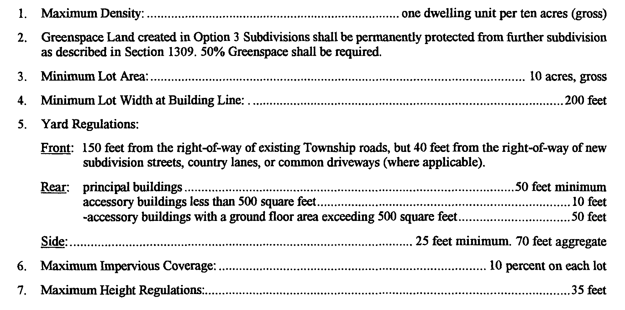
D. Dimensional Standards for Option 3 Subdivisions: "Country Properties"