
Purpose.�
The purpose of this ordinance is to require developers to evaluate and assess the impacts on the environment generated by land development projects and to enable the Planning Board or Zoning Board of Adjustment to review such environmental analysis in order to reduce the adverse impact of development on the environment.�
Requirements.�
A. An environmental impact evaluation of the site (hereafter "the study") shall be submitted by the applicant as required by the checklists.�
B. The environmental impact assessment shall be prepared by a person or persons having appropriate experience and background, and shall identify all relevant sources of information used in its preparation, and shall consider the topography, surface water bodies, energy, air quality, noise, surface water quality, aquatic biota, soils, geology, subsurface water, unique scenic or historic features, vegetation, wildlife and archaeological features of the entire site proposed for development. Forest vegetation shall be classified by type and age class. Map scales shall be no larger than I inch equals 1 00 feet, or as required by the Board.�
1. Topography - The study shall provide a topographic survey showing one foot contour intervals within the proposed areas of intended use and in the areas within the perimeter of disturbance. The study shall also include a relief map, showing areas of common elevation.�
2. Surface water bodies - Describe existing water courses and water bodies that abut, impact or are partially or totally on the site and their relationship to the area of land disturbance. Calculate existing surface runoff from the site. When the natural drainage pattern will be significantly altered, an analysis shall be conducted which will investigate flow, depth, capacity and water quality of the receiving waters. When required, flood plain areas shall be mapped in consultation with the New Jersey Department of Environmental Protection. Existing drainage structures shall be mapped and the capacity of the drainage network shall be determined.�
3. Energy - Describe the proposed energy sources for all elements of the project, and identify alternative conservation measures that may be utilized.�
4. Air quality - Describe each contamination source, its location, the quantity and nature of materials to be emitted from any furnace or other device in which coal, fuel, oil, gasoline, diesel fuel, kerosene, wood or other combustible material will be burned or if any other source of air pollutants, including vehicles attracted by the facility, will be present on the site during or after construction. If a state or federal emission permit is required, a copy of the permit and all resource data submitted with the application for the permit shall accompany the environmental assessment.�
5. Noise - Description of all noise generating equipment, both during construction and after construction shall be identified. The decibel level shall be measured and new sources supplied. Compliance shall be made with the East Brunswick noise ordinance.�
6. Surface water quality - Water quality analysis examining existing water quality conditions and protecting project impacts, with complete water testing according to the New Jersey Department of Environmental Protection to be performed by a New Jersey State Certified Laboratory.�
7. Aquatic biota - Describe and identify fish and plant life that may be associated with surface water bodies.�
8. Soils - Soils of the proposed area of land disturbance shall be mapped. List and describe each soil type located on the site, relative to the project proposed, including percolation data, depth to seasonal high water table (as indicated by the shallowest depth to soil mottling), erosion potential, aquifer recharge area and other factors related to soil as per the soil survey from the U.S. Department of Agriculture, Soil Conservation Service.�
9. Geology - Describe the geologic formations, including surficial deposits associated with the site, relative to the project proposed.�
10. Subsurface water - Describe subsurface water conditions on the site in terms of depth to ground water and water supply capabilities on the site. Where existing conditions warrant, provide information regarding existing wells within 500 feet of the site relative to depth, capacity and water quality. Detail the water supply capabilities of the adjacent areas and the recharge capabilities of the site.�
11. Unique scenic or historic features - Describe and map those portions of the site that can be considered to have unusual scenic and/or historic qualities and have unusual scenic and/or historic qualities and attributes.�
12. Vegetation - Describe existing vegetation on the site. A map shall be prepared showing the location of major vegetated groupings, such as woodlands, open fields and wetlands. Where woodlands are delineated, the forest types shall be indicated (for example: upland deciduous, lowland deciduous, etc.). Specimen trees are to be identified as to location and species.�
13. Wildlife - Identify and describe any protected species and habitats. Evaluate additions and losses to species and habitat areas.�
C. The environmental impact assessment should describe, with appropriate maps, the proposed project. The assessment shall summarize, rather than duplicate, the site plan and building plan. The assessment shall include a survey and description of the environmental features of the property. The scope and detail of the impact assessment will be determined by the Township staff, in consultation with the Environmental Commission.�
D. In the review of an applicant's plan, the Board shall consider both the potential adverse and the positive environmental impacts of any proposed project as major factors in its findings and shall make findings. The object shall be to reduce, minimize or eliminate adverse environmental factors caused by the proposed development.�
Critical Impacts.�
Plans shall include any area, condition or feature which is environmentally sensitive or which, it disturbed during construction, would adversely affect the physical, social or historic environment of the area.�
A. Critical impact areas include, but are not limited to, stream corridors, streams, wetlands, estuaries, slopes greater than 20 percent, high acid or high erodible soils, areas of high water table, mature stands of native vegetation, aquifer recharge areas and archaeologically sensitive areas.�
B. A statement of impact upon critical areas and a listing of adverse impacts which cannot be avoided shall be included.�
C. Proposed measures intended by the developer to minimize damage to critical impact areas shall be indicated, both for the construction period and post-construction period.�
D. A list of all licenses, permits, and other approvals that are required by municipal, county, regional, or. state law and a status of each shall be included.�
Approval.�
No application for development shall be approved unless the application has demonstrated to the satisfaction of the municipal agency, through the study and such other information as the application may provide, that the development:�
1. Will not result in a significant adverse impact on the environment.�
2. Has been conceived and designed in such a manner that it will not significantly impair natural processes.�
3. Will not. place disproportionate or excessive demand upon the total resources available to the project site or to the impact area.�
Waiver.�
The appropriate Board may waive any provision of this ordinance if deemed not applicable.�
[Amended 2-11-91 by Ord. No. 91-16; 5-13-91 by Ord. No. 91-48; 3-27-95 by Ord. No. 95-10]�
Fees for application or for the rendering of any service by the Boards or any members of their administrative staffs shall be as follows [Amended 3-17-95 by Ord. No. 95-10]:�
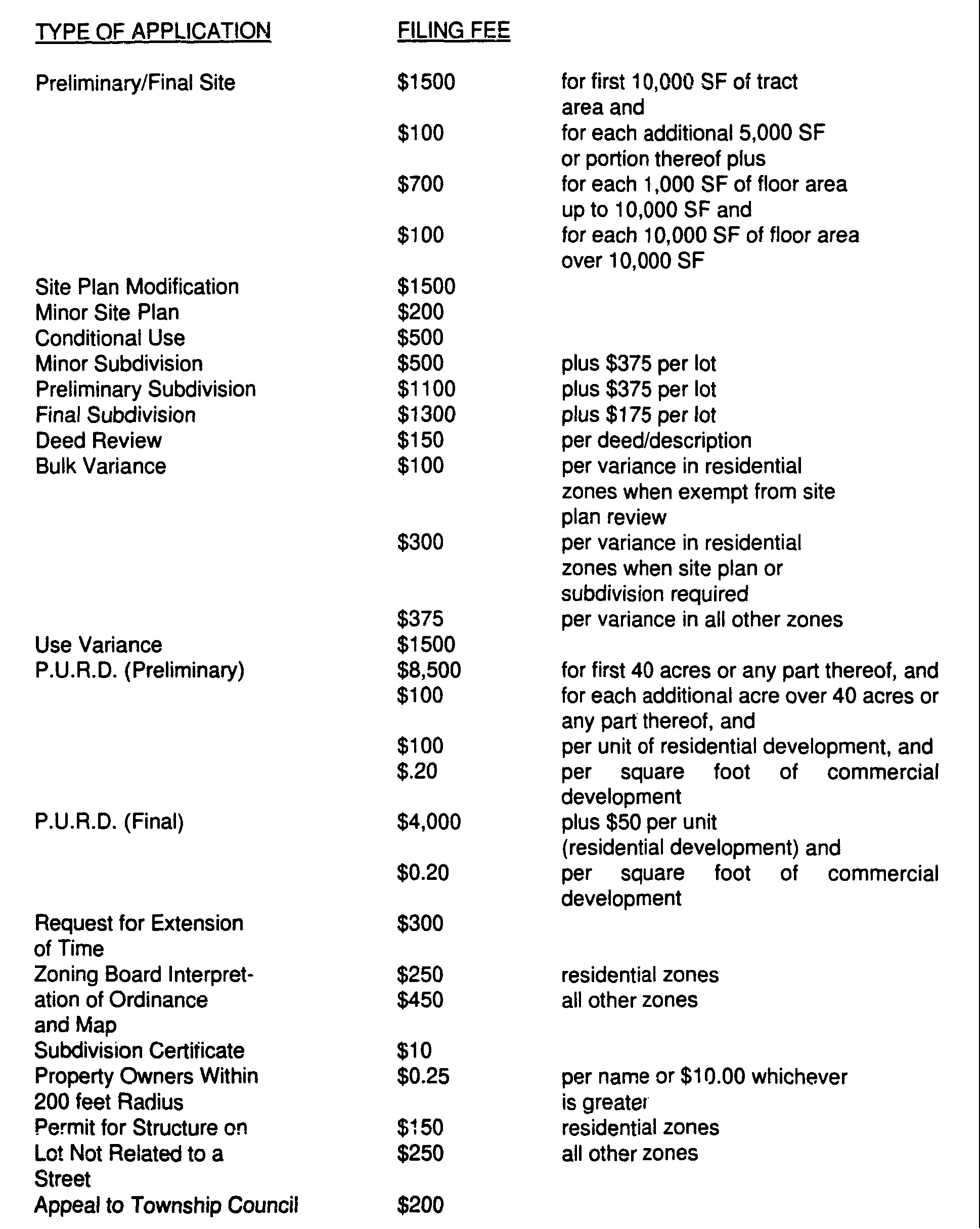

Where an applicant seeks more than one approval in an Application for Development, applicant shall pay an aggregate fee equal to the total of all separate fees payable for each approval requested in the Application for Development. For purposes of this section separate fees shall be payable for use variances and for bulk variances.�
No fee shall be required for a bulk variance from the requirements of the Zoning Ordinance where it involves a pre-existing condition. [Added 5-13-91 by Ord. No. 91-48]�
Whenever an application is made for site plan approval or a use variance with regard to a preexisting undersized lot or parcel, the fee for bulk variances shall not exceed $375.00, regardless of the number of new bulk variances required. [Added 5-13-91 by Ord. No. 91-48; amended 3-27-95 by Ord. No. 95-10]�
Refunds-Application fees involving site plan, subdivision and variance applications which are withdrawn prior to one week preceding the first scheduled public hearing are entitled to a refund in accordance with the following schedule:�
1. Prior to certification that application is complete - 90%.�
2. After certification but prior to one week preceding the first scheduled public hearing - 50%.�
Revised Plans-Each additional review of revised plans in accordance with Resolutions of approval adopted by the Planning or Zoning Board for approval compliance - $50.00 for minor and modified subdivisions and site plans, and $200.00 for major site plan and subdivision compliance review beyond the applicant's initial resubmission of plans.�
[Added 10-13-97 by Ord. No. 97-28; amended 2-23-98 by Ord. No. 98-8; 4-18-05 by Ord. No. 05-06; 4-24-6 by Ord. No. 06-15]�
A. Purpose - In Holmdel Builder's Association V. Holmdel Township, 121 N.J. 550 (1990), the New Jersey Supreme Court determined that mandatory development fees are authorized by the Fair Housing Act of 1985 (the Act), N.J.S.A. 52:27d-301 et sea., and the State Constitution, subject to the Council on Affordable Housing's (COAH's) adoption of rules. Pursuant to P.L.2008, c.46 section 8 (C. 52:27D-329.2) and the Statewide Non-Residential Development Fee Act (C. 40:55D8.1 through 8.7), COAH is authorized to adopt and promulgate regulations necessary for the establishment, implementation, review, monitoring and enforcement of municipal affordable housing trust funds and corresponding spending plans. Municipalities that are under the jurisdiction of the Council or court of competent jurisdiction and have a COAH-approved spending plan may retain fees collected from residential and non-residential development. �
This ordinance establishes standards for the collection, maintenance, and expenditure of development fees pursuant to COAH's regulations and in accordance P.L.2008, c.46, Sections 8 and 32-38. Fees collected pursuant to this ordinance shall be used for the sole purpose of providing low- and moderate-income housing. This ordinance shall be interpreted within the framework of COAH's rules on development fees, codified at N.J.A.C. 5:97-8. �
B. Basic requirements �
1. This ordinance shall not be effective until approved by COAH pursuant to N.J.A.C. 5:96-5.1. �
2. The Township of East Brunswick shall not spend development fees until COAH has approved a plan for spending such fees in conformance with N.J.A.C. 5:978.10 and N.J.A.C. 5:96-5.3. �
C. Residential Development Fees - All developers of residential developments for which minor or major subdivision or site plan approval are required shall pay a development fee of one and one half (1.5) percent of the equalized assessed value for each residential unit constructed. When an increase in residential density pursuant to N.J.S.A. 40:55D-70d(5) (known as a "d" variance) has been permitted, developers shall be required to pay a development fee of six percent (6%) of the equalized assessed value for each additional unit approved. However, if the zoning on a site has changed during the two-year period preceding the filing of such a variance application, the density for the purposes of calculating the bonus development fee shall be the highest density permitted by right during the two-year period preceding the filing of the variance application. [Amended 4-18-05 by Ord. No. 05-06; 4-24-06 by Ord. No. 06-15]�
D. Nonresidential Development Fees - Within all zoning districts, non-residential developers, except for developers of the types of development specifically exempted, shall pay a fee equal to two and one-half (2.5) percent of the equalized assessed value of the land and improvements, for all new non-residential construction on an unimproved lot or lots. Non-residential developers, except for developers of the types of development specifically exempted, shall also pay a fee equal to two and one-half (2.5) percent of the increase in equalized assessed value resulting from any additions to existing structures to be used for non-residential purposes �
Development fees shall be imposed and collected when an existing structure is demolished and replaced. The development fee of two and a half percent (2.5%) shall be calculated on the difference between the equalized assessed value of the pre-existing land and improvement and the equalized assessed value of the newly improved structure, i.e. land and improvement, at the time final certificate of occupancy is issued. If the calculation required under this section results in a negative number, the non-residential development fee shall be zero. �
Eligible exactions, ineligible exactions and exemptions for non-residential development: �
1) The non-residential portion of a mixed-use inclusionary or market rate development shall be subject to the two and a half (2.5) percent development fee, unless otherwise exempted below. �
2) Non-residential developments shall be exempt from the payment of nonresidential development fees in accordance with the exemptions required pursuant to P.L.2008, c.46, as specified in the Form N-RDF "State of New Jersey Non-Residential Development Certification/Exemption" Form. Any exemption claimed by a developer shall be substantiated by that developer. �
3) A developer of a non-residential development exempted from the nonresidential development fee pursuant to P.L.2008, c.46 shall be subject to it at such time the basis for the exemption no longer applies, and shall make the payment of the non-residential development fee, in that event, within three years after that event or after the issuance of the final certificate of occupancy of the non-residential development, whichever is later. �
4) If a property which was exempted from the collection of a non-residential development fee thereafter ceases to be exempt from property taxation, the owner of the property shall remit the fees required pursuant to this section within 45 days of the termination of the property tax exemption. Unpaid non-residential development fees under these circumstances may be enforceable by the Township of East Brunswick as a lien against the real property of the owner�
E. Collection of Fees. �
1. An estimated development fee shall be calculated by the certified financial officer or designee, utilizing estimates for equalized assessed value, prior to the issuance of a certificate of occupancy.�
2. Developers shall pay the estimated development fee in full to the Township of East Brunswick at the issuance of a certificate of occupancy. Such development fees shall be deposited into an escrow account and held until: (1) the tax assessor officially calculates the equalized assessed value in conjunction with the annual added assessment list, and (2) the final development fee using the equalized assessed value is calculated by the certified financial officer or designee. The developer shall be responsible for paying any difference between the amount paid at the time of issuance of a certificate of occupancy and the final development fee. The Township shall be required to refund any monies paid at the time of the issuance of a certificate of occupancy in excess of the final development fee.�
3. Collection procedures �
a. Upon the granting of a preliminary, final or other applicable approval, for a development, the applicable approving authority shall direct its staff to notify the Construction Official or designee responsible for the issuance of a building permit. �
b. For non-residential developments only, the developer shall also be provided with a copy of Form N-RDF "State of New Jersey Non-Residential Development Certification/Exemption" or its successor to be completed as per the instructions provided. The developer of a non-residential development shall complete Form N-RDF as per the instructions provided. The Construction Official or designee shall verify the information submitted by the non-residential developer as per the instructions provided in the Form N-RDF. The Tax Assessor shall verify exemptions and prepare estimated and final assessments as per the instructions provided in Form N-RDF. �
c. The Construction Official or designee shall notify the Tax Assessor of the issuance of the first building permit for a development which is subject to a development fee.�
d. Within 90 days of receipt of that notice, the Tax Assessor, based on the plans filed, shall provide an estimate of the equalized assessed value of the development. �
e. The Construction Official responsible for the issuance of a final certificate of occupancy or designee notifies the Tax Assessor of any and all requests for the scheduling of a final inspection on property which is subject to a development fee.�
f. Within 10 business days of a request for the Scheduling of a final inspection, the municipal assessor shall confirm or modify the previously estimated equalized assessed value of the improvements of the development; calculate the development fee; and thereafter notify the developer of the amount of the fee. �
g. Should East Brunswick Township fail to determine or notify the developer of the amount of the development fee within 10 business days of the request for final inspection, the developer may estimate the amount due and pay that estimated amount consistent with the dispute process set forth in subsection b. of section 37 of P.L.2008, c.46 (C.40:55D-8.6). �
F. Appeal of development fees �
1. A developer may challenge residential development fees imposed by filing a challenge with the County Board of Taxation. Pending a review and determination by the Board, collected fees shall be placed in an interest bearing escrow account by East Brunswick Township. Appeals from a determination of the Board may be made to the tax court in accordance with the provisions of the State Tax Uniform Procedure Law, R.S.54:48-1 et sea., within 90 days after the date of such determination. Interest earned on amounts escrowed shall be credited to the prevailing party. �
2. A developer may challenge non-residential development fees imposed by filing a challenge with the Director of the Division of Taxation. Pending a review and determination by the Director, which shall be made within 45 days of receipt of the challenge, collected fees shall be placed in an interest bearing escrow account by East Brunswick Township. Appeals from a determination of the Director may be made to the tax court in accordance with the provisions of the State Tax Uniform Procedure Law, R.S.54:48-1 et seq., within 90 days after the date of such determination. Interest earned on amounts escrowed shall be credited to the prevailing party. �
G. Affordable Housing Trust Fund �
1. There is hereby created an interest bearing housing trust fund for the purpose of receiving development fees from residential and nonresidential developers and proceeds from the sale of units with extinguished controls. All development fees paid by developers pursuant to this ordinance shall be deposited in this fund. No money shall be expended from the Affordable Housing Trust fund unless the expenditure conforms to a spending plan approved by COAH. The following additional funds shall be deposited in the Affordable Housing Trust Fund and shall at all times be identifiable by source and amount: �
a. payments in lieu of on-site construction of affordable units; �
�
b. developer contributed funds to make ten percent (10%) of the adaptable entrances in a townhouse or other multistory attached development accessible; �
c. rental income from municipally operated units; �
d. repayments from affordable housing program loans; �
e. recapture funds; �
f. proceeds from the sale of affordable units; and �
g. any other funds collected in connection with East Brunswick Township's affordable housing program. �
2. If COAH determines that the Township of East Brunswick is not in conformance with COAH's rules on development fees, COAH is authorized to direct the manner in which all development fees collected pursuant to this ordinance shall be expended. Such authorization is pursuant to: this ordinance, COAH's rules on development fees, and the written authorization from the Township Council to the bank in which the housing trust fund is located.�
H. Use of Funds �
1. The expenditure of all funds shall conform to a spending plan approved by COAH. Funds deposited in the housing trust fund may be used for any activity approved by COAH to address East Brunswick Township's fair share obligation and may be set up as a grant or revolving loan program. Such activities include, but are not limited to: preservation or purchase of housing for the purpose of maintaining or implementing affordability controls, rehabilitation, new construction of affordable housing units and related costs, accessory apartment, market to affordable, or regional housing partnership programs, conversion of existing non-residential buildings to create new affordable units, green building strategies designed to be cost saving and in accordance with accepted national or state standards, purchase of land for affordable housing, improvement of land to be used for affordable housing, extensions or improvements of roads and infrastructure to affordable housing sites, financial assistance designed to increase affordability, administration necessary for implementation of the Housing Element and Fair Share Plan, or any other activity as permitted pursuant to N.J.A.C. 5:97-8.7 through 8.9 and specified in the approved spending plan.�
2. Funds shall not be expended to reimburse the Township of East Brunswick for past housing activities. �
3. At least 30 percent of all development fees collected and interest earned shall be used to provide affordability assistance to low- and moderate-income households in affordable units included in the municipal Fair Share Plan. One-third of the affordability assistance portion of development fees collected shall be used to provide affordability assistance to those households earning 30 percent or less of median income by region. �
4. Affordability assistance programs may include down payment assistance, utility payment assistance, security deposit assistance, low interest loans, rental assistance, assistance with homeowners association or condominium fees and special assessments, and assistance with emergency repairs. �
5. Affordability assistance to households earning 30 percent or less of median income may include buying down the cost of low or moderate income units in the municipal Fair Share Plan to make them affordable to households earning 30 percent or less of median income. The use of development fees in this manner may entitle the Township of East Brunswick to bonus credits pursuant to N.J.A.C. 5:97-3.7. �
6. Payments in lieu of constructing affordable units on site and funds from the sale of units with extinguished controls shall be exempt from the affordability assistance requirement.�
7. The Township of East Brunswick may contract with a private or public entity to administer any part of its Housing Element and Fair Share Plan, including the requirement for affordability assistance, in accordance with N.J.A.C. 5:96-18. �
8. No more than 20 percent of all revenues collected from development fees, may be expended on administration, including, but not limited to, salaries and benefits for municipal employees or consultant fees necessary to develop or implement a new construction program, a Housing Element and Fair Share Plan, and/or an affirmative marketing program. In the case of a rehabilitation program, no more than 20 percent of the revenues collected from development fees shall be expended for such administrative expenses. Administrative funds may be used for income qualification of households, monitoring the turnover of sale and rental units, and compliance with COAH's monitoring requirements. Legal or other fees related to litigation opposing affordable housing sites or objecting to the Council's regulations and/or action are not eligible uses of the affordable housing trust fund.�
I. Monitoring�
The Township of East Brunswick shall complete and return to COAH all monitoring forms included in monitoring requirements related to the collection of development fees from residential and non-residential developers, payments in lieu of constructing affordable units on site, funds from the sale of units with extinguished controls, barrier free escrow funds, rental income, repayments from affordable housing program loans, and any other funds collected in connection with the Township of East Brunswick's housing program, as well as to the expenditure of revenues and implementation of the plan certified by COAH . All monitoring reports shall be completed on forms designed by COAH. �
J. Expiration of Ordinance �
The ability for East Brunswick Township to impose, collect and expend development fees shall expire with its substantive certification unless East Brunswick Township has filed an adopted Housing Element and Fair Share Plan with COAH, has petitioned for substantive certification, and has received COAH's approval of its development fee ordinance. If East Brunswick Township fails to renew its ability to impose and collect development fees prior to the expiration of substantive certification, it may be subject to forfeiture of any or all funds remaining within its municipal trust fund. Any funds so forfeited shall be deposited into the "New Jersey Affordable Housing Trust Fund" established pursuant to section 20 of P.L.1985, c.222 (C.52:27D-320). East Brunswick Township shall not impose a residential development fee on a development that receives preliminary or final site plan or subdivision approval after the expiration of its substantive certification, nor shall East Brunswick Township retroactively impose a development fee on such a development. East Brunswick Township shall not expend development fees after the expiration of its substantive certification. �
K. Definitions �
1. AFFORDABLE HOUSING DEVELOPMENT means a development included in the Housing Element and Fair Share Plan, and includes but is not limited to, an inclusionary development, a municipal construction project or a 100 percent affordable development. �
2. COAH or the "Council"means the New Jersey Council on Affordable Housing established under the Act which has primary jurisdiction for the administration of housing obligations in accordance with sound regional planning consideration in the State. �
3. DEVELOPER means the legal or beneficial owner or owners of a lot or of any land proposed to be included in a proposed development, including the holder of an option or contract to purchase, or other person having an enforceable proprietary interest in such land. �
4. DEVELOPMENT FEES means money paid by means money paid by a developer for the improvement of property as permitted in N.J.A.C. 5:97-8.3. �
5. EQUALIZED ASSESSED VALUE means the assessed value of a property divided by the current average ratio of assessed to true value for the municipality in which the property is situated, as determined in accordance with sections 1, 5, and 6 of P.L.1973, c.123 (C.54:1-35a through C.54:1-35c). �
6. GREEN BUILDING STRATEGIES means those strategies that minimize the impact of development on the environment, and enhance the health, safety and well-being of residents by producing durable, low-maintenance, resource-efficient housing while making optimum use of existing infrastructure and community services.�
7. JUDGMENT OF REPOSE means a judgment issued by the Superior Court approving a municipality's plan to satisfy its fair share obligation.�
8. SUBSTANTIVE CERTIFICATION means a determination by COAH approving a municipality's Housing Element and Fair Share Plan in accordance with the provisions of the Fair Housing Act of 1985, Chapter 5:96 NJ COAH Third Round Rules and N.J.A.C. 5:97. A grant of substantive certification may run for a period of ten years beginning on the date that a municipality files its Housing Element and Fair Share Plan with the Council in accordance with N.J.S.A. 52:27D-313, but shall not extend beyond December 31, 2019.�
�
**Webmasters Note: The previous section has been amended as per Ordinance No. 09-19.�

