
A. The standards and requirements outlined herein shall be considered minimum.�
B. All portions of a tract being subdivided or developed shall be taken up in lots, streets, public lands or other proposed uses so that remnants and landlocked areas shall not be created.�
C. Reserve strips controlling access to lots, public rights-of-way, public lands or adjacent private lands are prohibited.�
D. Lot lines shall not cross Township boundary lines. Subdivisions and land developments shall be laid out to minimize cut and minimize fill.�
E. Land subject to flooding as indicated in the Soil Survey of Bucks and Philadelphia Counties, Pennsylvania, shall be platted for residential occupancy or-other uses only in accordance with the resource protection requirements of the Solebury Township Zoning Ordinance particularly Article 14.�
A. The length, width, and shape of blocks shall be determined with due regard to the following:�
1. Provisions of adequate sites for the types of buildings proposed.�
2. Zoning requirements for lot sizes, dimensions.- and minimum lot areas per dwelling unit.�
3. The limitations and opportunities of the topography.�
4. Safe and convenient vehicular and pedestrian circulation and access. In the design of blocks. special consideration shall be given to the requirements of satisfactory fire protection.�
B. Blocks in subdivisions shall have a maximum length of sixteen hundred (1,600) feet, and a minimum length of five hundred (500) feet.�
C. Loop streets shall have an interval of at least 500 feet between intersections..�
A. Lot dimensions and areas exclusive of easements shall not be less than specified by provisions of the Zoning Ordinance.�
B. Corner lots and through lots shall provide for equal front yard setbacks on each street.�
C. Building setback lines shall be established in accordance with the Township Zoning Ordinance. (9/16/86)�
D. All lots must front on and have wholly owned access to either an existing or proposed Street- (9/16/86)�
E. Through lots shall be deed restricted to limit access to the lower order street.�
A. Utility casements shall be provided as necessary. Joint utilization of easements by two or more utilities is encouraged.�
B. To the fullest extent possible, easements shall be centered on or adjacent to mar or side lot lines.�
C. Easements shall be provided for utilities with a minimum width of thirty (30) feet for a single utility. Where multiple use of an easement is proposed an adequate width shall be determined by the Township.�
D. Nothing shall be permitted to be placed, planted, set or put within the area of a utility easement except lawns or suitable low ground cover.�
E. Where a subdivision or land development is traversed by a watercourse, there shall be provided a drainage easement or right-of-way provided to the Township conforming substantially with the line of such watercourse and of such width as will be adequate to preserve natural drainage but not less than thirty (30) feet, or as may be required or directed by the Township and/or the Department of Environmental Resources. The owner shall properly grade and seed slopes and fence any open ditches when deemed necessary by the Township.�
F. No right-of-way or easement for any purpose whatsoever shall be created, recited or described in any deed unless the same has been shown on the approved plan.�
A. An erosion and sedimentation (E&S) control plan shall be submitted with all applications wherein excavation, placement of fill, and/or grading activities are proposed. The plan shall include a construction staging narrative indicating the sequence of earthmoving activities, and proposed erosion and sedimentation control procedures. Measures used to control erosion and reduce sedimentation during construction activities shall strictly conform to the standards and specifications of the Bucks County Conservation District (BCCD) and sequence of earthmoving activities. Verification of approval of the E&S plan must be received in writing from the BCCD.�
B. Existing eroded stream/channel banks, roadside swales, and areas of shallow concentrated or sheet flow within a proposed subdivision/land development site must be stabilized by the developer. The subdivision application must include pictorial documentation of existing stream/channel banks for Township review. Use of stone rip-rap is discouraged.�
C. All erosion and sedimentation control measures shall be installed in accordance with the approved plan. Where a stormwater management basin is involved, the basin shall be constructed, functional, and stabilized prior to any additional site activity. An as-built plan of the facility prepared by a licensed surveyor shall be submitted to the Township for review to verify adequate stage/storage capacity prior to commencement of other site activity. Plan must include note stating same.�
D. It shall be the responsibility of each person, corporation or other entity performing grading and/or building activities to install and maintain erosion and sedimentation controls until the site is stabilized. In the event any mud and/or debris is transported from the site onto a public roadway, the mud and/or debris shall be immediately removed and the roadway swept and/or washed as deemed necessary by the Township at the owner's expense.�
E. Within any area to be set aside as open space for natural resources protection or for future agricultural use, there shall be no clearing, grading or topsoil stockpiles. Clearing and grading shall be permitted within open space areas only if the purpose is to accommodate recreational facilities, paths, or community greens.�
F. Individual lot grading plans shall be consistent with the subdivision or land development site grading plans and with the Township grading requirements. If during the building permit review process any revisions are made to the lot grading plan after the development plans were approved and recorded, the lot grading plans shall be resubmitted to the Township for reassessment and reapproval. Revisions include change of building footprint location or size, change to the first floor elevation exceeding 1 foot above or below the designated elevation on the site plan, and any revisions to site grading.�
A. All subdivision and land developments shall comply with the Solebury Township Stormwater Management Ordinance, Ordinance No. 2009-003, adopted on January 20, 2009, as amended.�
B. General.�
A. All subdivisions and land developments shall comply with the Low Impact Development Practices as outlined in the Pennsylvania Stormwater Best Management Practices Manual, December 2006, as amended ("Manual"), where consistent with design requirements of this Ordinance. The Manual provides guidance on the development of site controls through the use of Best Management Practices (BMPs). The most appropriate BMPs for stormwater management vary from site to site; however, the basic concepts are as follows:�
(a) Prevent stormwater impacts, especially pollutants.�
(b) Mitigate pollutants that cannot be prevented.�
(c) Manage stormwater as a resource.�
(d) Sustain the hydrologic balance (quantity and quality).�
(e) Integrate stormwater into the initial site design process.�
(f) Preserve and utilize natural systems (soil, vegetation, etc.).�
(g) Manage stormwater as close to the source as possible.�
(h) Disconnect/decentralize/distribute.�
(i) Slow down stormwater by increasing the time of concentration.�
(j) Inspect and maintain.�
C. Design Criteria.�
1. The stormwater management system shall be designed to meet the requirements of the Manual. In the event the Delaware River (South) Watershed or Neshaminy Creek Watershed Act 167 requirements are more restrictive, the Act 167 requirements shall apply as determined by the Township Engineer.�
2. The Township requires use of Nonstructural BMPs (refer Chapter 5 of the Manual) to the maximum extent possible because of their ability to prevent stormwater generation and not just mitigate stormwater-related impacts. If Nonstructural BMPs cannot be used, the reasons why must be demonstrated to the Township's satisfaction. Stormwater generation can be reduced by designing the subdivision or land development in ways other than through use of standard or conventional development practices. Prevention and Nonstructural BrviPs are in contrast with Structural BMPs (refer Chapter 6 of the Manual) that provide mitigation of stormwater impacts which cannot be prevented and/or avoided.�
3. The following major "areas" of preventative Nonstructural BMPs have been identified in the Manual:�
Protect Sensitive and Special Value Features �
Cluster and Concentrate�
Minimize Disturbance and Minimize Maintenance �
Reduce Impervious Cover�
Disconnect/Distribute/Decentralize�
Source Control�
Specific Nonstructural BMPs have been identified for each of these generalized areas, to better define and improve implementation. One of the most challenging technical issues considered in the Manual involves the selection of BMPs that have a high degree of Non-point Source (NPS) reduction or removal efficiency. In the ideal, a BMP should be selected that has a proven NPS pollutant removal efficiency for all pollutants of importance, especially those that are critical in a specific watershed.�
4. Chapter 8 of the Manual provides a methodological approach to take credit for applying these Nonstructural BMPs, provided that the "specifications" defined for each BMP in Chapter 5 of the Manual are properly followed.�
5. The developer shall construct and/or install such drainage structures, onsite and offsite as necessary to provide a fully functioning stormwater collection and control system meeting the requirements of the Manual. The developer's design shall utilize Nonstructural BMPs to the maximum extent possible and consistent with other requirements of this Ordinance.�
D. On-lot drainage swales shall be designed to provide positive conveyance of surface water from the individual lot. Each swale lot shall convey stormwater from the lot to a storm sewer system, street, open space area, or stormwater management easement without crossing or combining with stormwater from more than the adjacent lot.�
E. Drainage swales necessary to control surface drainage between lots shall be centered on the common property line.�
F. Whenever a watercourse, is located within a development site, it shall remain open in its natural state and location, and shall not be piped (except for road crossings).�
G. Where a subdivision or land development is traversed by a watercourse there shall be provided a drainage easement or right-of-way conforming substantially with the line of such watercourse. The width of the easement shall be adequate to provide for unimpeded flow of stormwater runoff from the 100-year return storm event. However, in no case shall the easement be less than thirty (30) feet in width. Terms of the easement shall prohibit excavation, the placing of fill or structures, and any alterations which may adversely affect the flow of stormwater runoff within any portion of the easement. Periodic maintenance of the easement to ensure proper runoff conveyance may be required by the landowner.�
H. During review of the stormwater management plan, if the Township determines that offsite improvements are necessary to satisfactorily manage stormwater runoff from the proposed subdivision or land development, the developer shall be responsible for design and construction of those offsite improvements.�
I. The tributary area discharging stormwater runoff to any location along the site property boundary shall not increase by more the twenty five (25) percent over the predevelopment condition without written approval from the adjacent affected property owner(s).�
J. Existing points of concentrated drainage discharge onto adjacent property shall not be altered without written agreement of the affected property owner(s) and Township; and shall be subject to any applicable discharge criteria specified in the Stormwater Management Ordinance. The agreement shall be recorded at the Bucks County Office of Recorder of Deeds and assignable to future owners.�
K. Areas of existing sheet flow which discharge onto adjacent property shall be maintained whenever possible. If sheet flow is proposed to be concentrated and discharged onto adjacent property, the developer must document that there are adequate downstream conveyance facilities to safely transport the concentrated discharge or otherwise prove that no harm will result from the concentrated discharge; and submit written approval from the affected adjacent property owner(s).�
L. Any required drainage facilities that are located on, or discharge to, a State highway right-of-way shall be subject to approval by the Pennsylvania Department of Transportation.�
M. Storm drainage facilities and appurtenances shall be so designed and provided as to minimize erosion in swales, watercourse channels and at all points of discharge.�
�
N. Storm sewers, culverts, and related installations shall be provided to permit the flow of natural watercourses, to ensure the drainage of all low points (except in protected "wetlands") on the subdivided lots or developed land areas and along the line of streets, and to intercept stormwater runoff along the streets at intervals related to the extent and grade of the area drained. The system shall also be designed to accommodate or receive and discharge all runoff from adjacent upstream properties. Where adequate existing storm sewers are readily accessible, the developer must connect new stormwater facilities to the existing system.�
O. All proposed streets shall be designed so as to discharge surface water from their rights-of-way. Storm drainage improvements as deemed necessary by the Township shall be required along all existing streets which a subdivision or land development abuts.�
P. No piped storm sewer system outlet, detention basin, or energy dissipation structure shall discharge closer than twenty (20) feet from the boundary of any drainage easement under the control of the developer or which may be utilized by the developer, so as to allow for adequate space for stormwater dissipation in vegetated land areas controlled by or available to the developer and/or to allow adequate space for equipment access for future maintenance.�
**Webmasters Note: The previous sections, 5.11 and 5.12, have been amended as per Ordinance No. 2009-008. The numbering of the previous sections is consistent with the original document.�
A. General�
1. All subdivision and land development plans shall include designed methods to withhold and release, at a controlled rate, any run-off onto adjacent property.�
2. Lots shall be laid out and graded to provide positive drainage away from buildings.�
3. Storm sewers, culverts, and related installations shall be provided:�
a. to permit unimpeded flow of natural watercourses and in such a manner as to protect the natural character of the watercourses and to provide regulated discharge;�
b. to insure adequate drainage of all low points along the line of streets; and,�
c. to intercept storm water run-off along streets at intervals reasonably related to the extent and grade of the area drained and to prevent substantial flow of water across intersections.�
4. Storm sewers, as required, shall be placed in the right-of-way, parallel to the roadway and shall be designed as a combination storm sewer and underdrain. When located in undedicated land, they shall be placed within an easement not less than twenty (20) feet wide, as approved by the Township Engineer.�
�
5. Manholes shall be not more than three hundred (300) feet apart on sizes up to twenty-four (24) inches, and not more than four hundred fifty (450) feet apart on greater sizes. Inlets may be substituted for manholes, on approval by the Township Engineer at the same spacing as required for manholes. In no case shall inlets be spaced more than four hundred fifty (450) feet apart.�
6. Inlets and manhole covers and frames shall conform to Pennsylvania Department of Transportation Specifications. At street intersections, inlets shall be placed in the tangent and not in the curved portion of the curbing.�
7. Storm water roof drains shall not discharge water directly onto a sidewalk or a street, and shall be constructed to retain all discharge wholly on the property except where such discharge can be conveyed to a storm sewer system.�
8. Drainage structures, which drain watershed areas in excess of one half square mile (320 acres), or which have a span of eight (8) feet or more, shall be designed for a maximum expected run-off as calculated using the Soil Conservation Service Technical Release 55 "Urban Hydrology for Small Watersheds (less than 2000 acres)". The design storm shall be a minimum 50-year storm. A 100- year storm shall be used if the structure will significantly affect the existing 100-year floodplain. A Water Obstruction Permit shall be obtained from the Pennsylvania Department of Environmental Resources for the waterway opening before final design is undertaken.�
The cartway area over the bridge shall be as wide as the widest road connecting with the bridge, or if the character of the road is expected to change for future planning, the cartway of the bridge shall be made to anticipate this condition.�
B. Maximum Expected Discharge�
1. The maximum expected discharge (M.E.D.) shall be defined as the maximum expected quantity of water, created by the design storm, arriving at a particular location (inlet, ditch, etc.).�
2. The design storm is a selected intensity of rainfall, which tends to occur once during a specified period of years.�
3. The Soil Conservation Service Technical Release #55 "Urban Hydrology for Small Watersheds (less than 2000 acres)" shall be used for the calculation of the maximum expected discharge.�
4. The maximum expected discharge from drainage areas contributing to the storm drain pipe system may be determined by the use of the Rational Equation, when the total drainage area does not exceed 100 acres.�
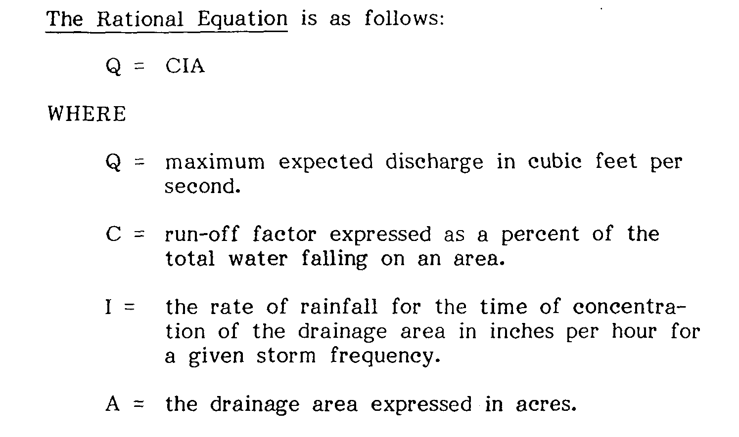
The above equation assumes that one inch of rainfall failing on one acre of land falls at the rate of one cubic foot per second. Thus, the total quantity of water falling on an area is represented by IA.�
5. It is necessary to adjust the total quantity of water falling on an area (IA) because certain percentage of the water is dissipated by evaporation, transpiration, percolation, ponding, and physical characteristics such as sinkholes. Therefore, the run-off factor 'IC" is introduced into the Rational Equation to account for the dissipated water.�
a. The run-off factor IC" is a percentage factor which represents the proportion of the total quantity of water falling on the area that remains as run-off.�
b. Consideration should be given to future land use changes in the drainage area in selecting the IC" factor. For drainage areas containing several different types of ground cover, a weighted value of 'IC" must be used.�
c. In no case shall a weighted value of 'IC" be less than 0.40 for an area to be changed from its natural state.�
6.�

