
A. No subdivision plat may be filed with the county recording officer until it has been approved by resolution of the Planning Board or, where appropriate, by resolution of the Zoning Board of Adjustment.�
B. No permit for any development, except as set forth below, may be issued until approval of site plans has been obtained by resolution of the Planning Board or, where appropriate, by resolution of the Zoning Board of Adjustment. Individual lot applications for detached one-dwelling-unit buildings shall be exempt from site plan review or approval. The Planning Board may waive site plan approval or delegate the authority to the Zoning Officer. Any request for waiver of site plan shall be reviewed by the Township Planner, who shall submit a report to the Planning Board. All costs of said review shall be met by the applicant through the submitting of fees and escrows equal to 1/2 the amount for preliminary site plan approval. [Amended 6-3-1991 by Ord. No. 8-91]�
C. Minor site plan. [Added 12-7-1992 by Ord. No. 25-92]�
(1) When an application is submitted for change of business tenant or home occupation or for modification of a business property relating to an area of 100 square feet or less not otherwise affecting on-site circulation, parking, lighting, waste disposal, recycling, drainage or other public health and safety issues, the applicant may apply for minor site plan approval. This process is intended to be an expedited process balancing the need of the municipality to ensure that the public's health, safety and welfare are properly safeguarded with the municipal objective of ensuring that the process is least cost to the applicant and minimally time consuming. An application for minor site plan shall include:�
(a) A plan based on Tax Map or other existing data indicating the shape and location of the property.�
�
(b) The location of buildings, parking, lighting, signage, water supply and septic disposal facilities.�
(2) The fee for minor site plan shall be $200 except in the case of a home occupation application where the fee shall be $50, plus an escrow deposit of $1,000 except in the case of a home occupation application where the escrow deposit shall be $300. Unused escrow will be refunded to the applicant upon issuance of a certificate of occupancy. [Amended 9-8-1997 by Ord. No. 97-10]�
(3) Any and all home occupations currently in existence as of the date of adoption of this Subsection C may submit an application for review to the Township Planning Board in accordance with the above provisions and the provisions of Chapter 105, Zoning, of the Code of the Township of Liberty for review.�
(4) Upon the finding by the township that the existing activity does not have an adverse impact on adjacent properties and is not such as to pose a hazard to the public health, safety and welfare, such use shall be established as a properly approved use within the township and a certificate of occupancy shall issue.�
Where application for subdivision or site plan approval is required to be made to the Warren County Planning Board pursuant to N.J.S.A. 40:27-6.3 or 40:27-6.6 (Sections 5 and 8 of P.L. 1968, c. 285), the Planning Board shall condition any approval that it grants upon timely receipt of a favorable report on the application from the County Planning Board or upon approval by the County Planning Board by its failure to report thereon within the required time period.�
A. Complete application. An application for development shall be completed for the purpose of commencing the applicable time period for action when the application is deemed complete by the Planning Board in action taken at a regularly scheduled meeting or at a special meeting where the same is deemed necessary by the Board.�
B. Procedures for applications for development.�
(1) All applications for development, whether before the Planning Board or the Board of Adjustment, must be complete applications before the respective approving authority will take any action on the application. All applicable time periods for action will commence when the application is deemed complete by the approving authority.�
(2) All applications for development must be submitted a full 21 days prior to the meeting of the approving authority at which it is to be heard and must be accompanied by a completed checklist indicating the items submitted.�
�
(3) The applicant will be notified if an application is deemed complete or incomplete not later than 45 days after submission of such an application. In the event that the applicant is notified that the application has been deemed complete, said notification will include a date at which the application may be heard by the Planning Board or Board of Adjustment, as appropriate. At that time the applicant shall serve notice to all appropriate parties as indicated in N.J.S.A. 40:55D-10. [Amended 9-8-1997 by Ord. No. 97-10]�
(4) In the event that the approving authority has not deemed the application complete within 45 days of the date of its submission, the application shall be deemed complete upon the expiration of the forty-five-day period for purposes of commencing the applicable time period unless:�
(a) The application lacks the information indicated on the checklist in Subsection C below and provided by the applicant; and�
(b) The approving authority has notified the applicant in writing of the deficiencies in the application within 45 days of submission of the application.�
(5) The applicant may request that one or more of the submission requirements be waived, in which event the approving authority shall grant or deny the request within 45 days.�
(6) Nothing herein shall be construed as diminishing the applicant's obligation to prove in the application process that he is entitled to approval of the application.�
(7) The approving authority may subsequently require correction of any information found to be in error and submission of additional information not specified in this chapter or any revisions in the accompanying documents as are reasonably necessary to make an informed decision as to whether the requirements necessary for approval of the application have been met.�
C. Checklist requirements.�
(1) Listed in Subsection C(2) below are the types of applications for development and a listing of the checklist requirements of Subsection C(2) which must be complied with for each type of application. The checklist is intended as a general reference for the applicant, and it is not intended to replace or supersede the actual provisions of this chapter. In addition, it is the sole responsibility of the applicant to determine prior to the submission of the application whether or not any variances are required and which municipal board the applicant should be before.�
(2) Checklist requirements.�
(a) Required items shall be as follows:�
[1] Minor subdivision: Per attached checklist dated October 18, 2002.�
[2] Preliminary major subdivision: Per attached checklist dated October 18, 2002.�
**Webmasters Note: The previous subsections [1&2] have been amended as per Ord. No. 03-�
02.�
[3] Final major subdivision: Per attached checklist. [Amended 12-15-1998 by Ord. No. 98-21; 11-4-1999 by Ord. No. 99-11]�
[4] Minor site plan: Per attached checklist.5 [Amended 12-15-1998 by Ord. No. 98-21; 11-4-1999 by Ord. No. 99-11]�
[5] Preliminary major site plan: Per attached checklist.6 [Amended 12-15-1998 by Ord. No. 98-21; 11-4-1999 by Ord. No. 99-11]�
[6] Final major site plan: Per attached checklist. [Amended 12-15-1998 by Ord. No. 98-21; 11-4-1999 by Ord. No. 99-11]�
[7] Application or appeal for a bulk variance, pursuant to N.J.S.A. 40:55D-70c: Items in Subsection C(2)(b)[1] through [6] and [12], [13], [15] and [16] are required and any other checklist requirements dependent on the nature of the application, i.e., site plan, subdivision, etc.�
[8] Conditional use application: Items in Subsection C(2)(b)[1] through [6] and [12], [13], [15] and [18] are required and any other checklist requirements dependent on the nature of the application, i.e., site plan, subdivision, etc.�
[9] Application or appeal for a use variance, pursuant to N.J.S.A. 40:55D-70d: Items in Subsection C(2)(b)[1] through [6] and [8], [9], [12], [13], [15], [17] and any other checklist requirements dependent on the nature of the application, i.e., site plan, subdivision, etc.�
[10] Request for interpretation of Zoning Map or Ordinance, pursuant to N.J.S.A. 40:55D-70b: Items in Subsection C(2)(b)[1] through [6] and [12] and [19] and any other checklist requirements dependent on the nature of the application, i.e., site plan, subdivision, etc.�
[11] Application or appeal for a variance for a building lot which does not abut a street, pursuant to N.J.S.A. 40:55D-36: Items in Subsection C(2)(b)[1] through [6] and [12], [13] and [16] and any other checklist requirements dependent on the nature of the application, i.e., site plan, subdivision, etc.�
[12] Application for concept approval: Items. [Added 11-2-1995 by Ord. No. 25-95]�
[13] All applications: Per attached application checklist.' [Added 12-15-1998 by Ord. No. 98-21; 11-4-1999 by Ord. No. 99-11]�
(b) Zoning Board of Adjustment, Variance Checklist. [Amended 8-7-1989 by Ord. No. 6-89; 11-6-2003 by Ord. No. 12-2003]�
�
A. The applicant shall file with the Secretary of the Planning Board 12 black- or blue-on-white prints of a concept plan which has been certified by a land surveyor licensed by the State of New Jersey, together with three completed applications for classification, the required fee and the materials set forth in Subsection E of this section. Applications shall be completed in accordance with § 90-6.1 of this chapter. [Amended 2-1-1988; 11-2-1995 by Ord. No. 25-95]�
B. (Reserved)�
C. An application number will be assigned to the application by the Secretary and will be used on all papers, maps and documents submitted in conjunction with the application.�
D. The Secretary of the Planning Board shall forward one copy of the submitted materials to each of the following persons: the Township Engineer, the Zoning Officer, the Construction Official, the Township Planner and the Chairman of the Subdivision and Site Plan Review Subcommittee and shall request each to review the application and report their findings and recommendations to the Board prior to the next regular meeting of the Board. [Amended 7-6-1987; 11-2-1995 by Ord. No. 25-95]�
E. Concept plan materials. [Amended 2-1-1988; 8-7-1989 by Ord. No. 6-89; 11-2-1995 by Ord. No. 25-95]�
(1) The following concept plan materials must be submitted by the applicant:�
(a) A site location or key map at a scale of not less than one inch equals 1,000 feet showing the relation of the property to be subdivided to the entire tract and the relation of the entire tract to the surrounding areas for at least one thousand (1,000) feet beyond the boundaries of the entire tract.�
**Webmasters Note: The previous sections, 90-6.1.C(2)(a)[11] through 90-7.E(1)(a), have been amended as per a supplement dated 3-1-2004.�
(b) Existing and proposed streets and roads.�
(c) Significant natural and man-made features, including streams, wetlands and other water bodies, topography of the site with specific reference to slopes in excess of twenty-five percent (25%), highly erodible soils, historic sites, subsurface geology, etc.�
(d) Zone district and requirements thereof.�
(e) Title, North point, written and graphic scales, Tax Map sheet and the block and lot number of the tract.�
(f) The name of the applicant, owner and preparer of plans.�
(2) Minor subdivisions. A detailed plat of the proposed subdivision based on survey data by a licensed land surveyor (minor subdivision) or Tax Map data (concept major subdivision) at a scale of between one (1) inch equals fifty (50) feet and one (1) inch equals two hundred (200) feet (concept) to clearly show, delineate and include the following data:�
(a) Existing lots, buildings and structures, driveways, streets and roads, brooks, streams, drainage ditches, floodplain delineations, individual and public water and sewerage facilities on the tract and within two hundred (200) feet thereof, including the names of all adjoining property owners as described by the most recent municipal tax records. In addition thereto, all wetlands and other significant environmental features shall also be shown.�
(b) Proposed dedications and reservations of areas for streets and roads, drainage rights-of-way, conservation areas and school sites on the tract and within two hundred (200) feet thereof.�
(c) Proposed lot and street lines with dimensions, lot areas shown in square feet and zoning setback front, side and rear yard lines. All lot lines shall be shown to the nearest second, distances shall be shown to the nearest one-hundredth (1/100) of a foot and lot areas shall be shown in square feet.�
(d) The plat shall also contain a title, name of subdivision tract, if any, North point, written and graphic scales, date, name, address, seal and signature of land surveyor who prepared the plan, dates of all revisions, Tax Map sheet, block and lot numbers and acreage of tract being subdivided, as well as the name and address of the owner and subdivider so designated, as well as North arrow and reference meridian.�
(e) Where a public sewerage system is not available and individual sewage disposal facilities must be utilized, the developer shall per-form two (2) percolation tests no closer than twenty (20) feet to each other and no further than forty (40) feet from each other with rates of no greater than sixty (60) minutes and two (2) soil logs no closer than twenty (20) feet to each other and no further than forty (40) feet from each other with no evidence of seasonal high-water table of less than twenty-four (24) inches, the same to be witnessed by the Warren County Health Department for each lot in question, including the remainder following the provisions of P.L. 1954, c. 199, and amendments and shall submit the results with the preliminary plat. Any subdivision or part thereof which does not meet with established requirements of P.L. 1954, c. 199, for design and construction of an individual sewage disposal system shall not be approved for building purposes. Any remedy proposed to overcome such a situation shall first be approved by the appropriate local, county or state health agency. The developer shall submit a plan showing proposed location of individual systems and shall also submit typical designs and layouts for individual sewage disposal systems, the location and results of soil logs and percolation tests performed on each lot, including the remainder, two logs and two percolation tests to be performed on each lot. Tests with rates in excess of 60 minutes per inch or indication of seasonal high-water table at 24 inches or less are not acceptable. All soil logs and percolation tests performed for development applications must be witnessed by the Township Engineer or his designee in accordance with the requirements outlined in Chapter 125 of the Municipal Code.�
(f) The plat shall contain a delineation of wetlands in metes and bounds and by type as defined by the United States Army Corps of Engineers, which data shall be signed by a qualified environmentalist. Further, upon the effective date of any legislation with respect to regulations defining wetlands and standards with respect to the development thereof and causing the implementation of said regulations to come within the jurisdiction of the New Jersey State Department of Environmental Protection, then and in that event, the developer shall adhere to those then effective standards.�
(g) Location of all monuments to be set. At least one monument shall be located at the conjunction of a property corner and a public street. Said monument shall be inscribed with the elevation at the top of the monument relative to MSL. [Added 12-7-2000 by Ord. No. 2000-11]�
F. (Reserved)�
G. (Reserved)�
H. Minor subdivision approval shall be deemed to be a final approval of the subdivision by the Board, but the Board may condition such approval on terms which ensure the construction of improvements as may be required under this chapter.�
I. [Amended 6-1-1992 by Ord. No. 15-92] Minor subdivision approvals shall be granted or denied within 45 days of the date of submission of a complete application to the Planning Board or within such further time as may be consented to by the applicant. Approval of a minor subdivision shall expire 190 days from the date on which the resolution of municipal approval is adopted, unless, within such period, a plat in conformity with such approval and the provisions of the Map Filing Law, 12 or a deed clearly describing the approved minor subdivision, is filed with the county recording officer, the Township Engineer and the Township Tax Assessor.�
(1) The Planning Board may also extend the one- hundred-ninety-day period for filing a minor subdivision plat or deed as hereinabove set forth if a developer proves to the reasonable satisfaction of the Planning Board that the developer was barred or prevented, directly or indirectly, from filing said map because of delays in obtaining legally required approvals from other governmental or quasi-governmental entities and that the developer applied promptly for and diligently pursued the required approvals. The length of the extension shall be equal to the period of delay caused by the wait for the required approvals, as determined by the Planning Board. The developer may apply for the extension either before or after what would otherwise be the expiration date.�
(2) The Planning Board shall grant an extension of minor subdivision approval for a period determined by the Board, but not exceeding one year from what would otherwise be the expiration date, if the developer proves to the reasonable satisfaction of the Board that the developer was barred or prevented, directly or indirectly, from proceeding with the development because of delays in obtaining legally required approvals from other governmental entities and that the developer applied promptly for and diligently pursued the required approvals. A developer shall apply for the extension before what would otherwise be the expiration date of minor subdivision approval or before the 91st day after the developer receives the last legally required approval from other governmental entities, whichever occurs later.�
J. Failure of the Planning Board to act within the period prescribed shall constitute minor subdivision approval, and a certificate of the administrative officer as to the failure of the Planning Board to act shall be issued on request of the applicant.�
K. The zoning requirements and general terms and conditions, whether conditional or otherwise, upon which minor subdivision approval was granted shall not be changed for a period of two years after the date of minor subdivision approval, provided that the approved minor subdivision shall have been duly recorded as provided in this section.�
A. At least 12 black- or blue-on-white prints of a preliminary plat and such other information as is hereafter required and three complete application forms for preliminary approval shall be submitted to the Secretary of the Planning Board not more than 25 days nor less than 21 days prior to a regular meeting of the Planning Board at which the application is to be considered. Applications shall be completed in accordance with § 90-6.1 of this chapter. [Amended 2-1-1988]�
B. The Secretary of the Planning Board shall forward one copy of the application to each of the following: the Township Clerk, the Township Planner, the Township Engineer and the Chairman of the Subdivision and Site Plan Review Committee and Warren County Planning Board, and shall request that each file a written report of findings and recommendations forthwith for submission to the Planning Board at its next regular meeting. [Amended 8-7-1989 by Ord. No. 6-89]�
C. The Secretary of the Board shall also forward one copy of the application to each of the following: the Board of Health, the Board of Education, the Police Department, the Fire Department and such others as directed by the Chairman of the Planning Board, and shall request them to file a written report of findings and recommendations for submission to the Planning Board at its next regular meeting.�
D. The administrative officer shall notify the applicant of the time and place of a public hearing, and the applicant shall then comply with the notice and hearing requirements of this chapter.�
E. If the application for development is found to be incomplete, the developer shall be notified, in writing, thereof within 45 days of submission of such application or it shall be deemed to be properly submitted. All soil logs and percolation tests performed for development applications must be witnessed by the Township Engineer or his designee in accordance with the requirements outlined in Chapter 125 of the Municipal Code.�
**Webmasters Note: The previous sections, 90-7.E(2)(e) through 90-8.E, have been amended as per a supplement dated 5-1-2001.�
F. The purpose of the preliminary plat is to transfer the proposals of the sketch plat to a precise base to verify their feasibility and merit. All drawings are to be prepared and certified by a professional engineer and a land surveyor. The following preliminary plat materials and detail design plans and data must be presented:�
(1) A site location or key map, not smaller than one (1) inch equals one thousand (1,000) feet, showing the relation of the portion to be subdivided to the entire tract and the relation of the entire tract to its surrounding areas for at least one thousand (1,000) feet beyond the tract. The key map shall show and include for the area delineated thereon:�
(a) Existing and proposed streets and roads, streams and watercourses, floodplain delineations, conservation areas, parks, schools and governmental facilities and sites and lots and at least one (1) intersection, per the Tax Map. [Amended 8-7-89 by Ord. No. 689]�
(b) Delineations and classifications of all zoning districts for the areas shown.�
(c) North point, written and graphic scales and Tax Map sheet, block and lot numbers of the tract being subdivided.�
(d) In addition to the above, a site layout map shall be prepared at the scale of the appropriate Township Tax Map. [Added 8-7-89 by Ord. No. 6-89]�
(2) [Amended 2-1-88; 8-7-89 by Ord. No. 6-89] A preliminary plat map of the proposed subdivision using a land survey as a base, drawn at a scale of between one (1) inch equals twenty (20) feet to one (1) inch equals one hundred (100) feet to clearly show, delineate and include the following data:�
(a) Lot layout, lot dimensions and individual lot areas, in square feet. All lot bearings shall be to the nearest hundredth of a foot, lot areas to the nearest foot�
(b) Existing contours, based on United States Geological Survey datum, at vertical intervals of not greater than two (2) feet, together with spot elevations to determine general slope and natural drainage of the land and high and low points. For all land with slopes in excess of fifteen percent (15%) contours shall be shown at five- foot intervals. Floodplain delineations for the one-hundred-year storm shall be shown.�
(c) Existing lots, buildings and structures, with an indication of whether they will be retained or removed, and the extent of wooded areas, including isolated individual trees over eighteen (18) inches in diameter.�
(d) Existing and proposed streets, easements, suggested street names, proposed building setback lines for each street, dedication and reservations of areas for drainage rights- of-way, parks, conservation areas and floodplain delineations.�
(e) General note delineating proposed methods of water supply and sewage disposal to service the development tract.�
(f) A title, name of subdivision tract, if any, North point reference meridian, written and graphic scale, name, address, seal and signature of engineer and land surveyor who prepared the plan, date of all revisions, Tax Map sheet, block and lot numbers and acreage of tract being subdivided, as well as name and address of the owner and subdivider so designated and delineation and names of all adjacent property owners within two hundred (200) feet of the boundary of the subdivision tract.�
(g) A delineation of wetlands in metes and bounds and by type as defined by the United States Army Corps of Engineers, which data shall be signed by a qualified environmentalist. Further, upon the effective date of any legislation with respect to regulations defining wetlands and standards with respect to the development thereof and causing the implementation of said regulations to come within the jurisdiction of the New Jersey State Department of Environmental Protection, then and in that event, the developer shall adhere to those then effective standards.�
(h) All plats shall be drawn so as to be consistent with and tied into the New Jersey State Plan Coordinate System dated 1983 or as thereafter amended. [Added 12-6-2001 by Ord. No. 2001-9]�
(3) Preliminary design plans and data shall be submitted and shall include details of all designs, constructions and proposed improvements to be made and installed as part of the overall project and shall include:�
(a) Plans and profiles at a scale not smaller than one inch equals 50 feet horizontal and one inch equals five feet vertical and cross-sections at a scale not smaller than one inch equals five feet (horizontal and vertical) of all proposed streets within the subdivision and - existing streets abutting the subdivision. The chord bearings, distances, arc lengths and radii of all curves along all street lines shall be shown.�
(b) Typical cross-sections for all streets, indicating dimensions, materials and types of construction of roadway pavements, curbs, sidewalks, planting strips, driveway entrances, shade tree plantings, grading, etc.�
(c) Maps, profiles, plans and supporting data showing existing area drainage, both on- and off-site, upstream and downstream watercourses, structures, brooks and floodplain delineations, including area and runoff calculations and engineering evaluations of existing facilities and their ability to accept increased runoff, and plan proposals for improvements to existing facilities and proposed additional area-wide drainage constructions shall be submitted.�
(d) Maps, profiles, plans, calculations, details of design and construction of all on-site drainage facilities proposed, including plans for all final site grading. Contours for final site grading shall be based on United States Geological Survey datum and shall be at a vertical interval of not greater than one foot, with spot elevations at all high and low points shown.�
(e) Where a public sewerage system is not available and individual sewerage disposal facilities must be utilized, the developer shall perform two percolation tests no closer than 20 feet to each other and no further than 40 feet from each other with rates of no greater than 60 minutes and two soil logs no closer than 20 feet to each other and no further than 40 feet from each other with no evidence of seasonal high water table of less than 24 inches, the same to be witnessed by the Warren County Health Department for each lot in question, including the remainder following the provisions of P.L. 1954, c. 199, and amendments' and shall submit the results with the preliminary plat. Any subdivision or part thereof which does not meet with established requirements of P.L. 1954, c. 199, for design and construction of an individual sewage disposal system shall not be approved for building purposes. Any remedy proposed to overcome such a situation shall first be approved by the appropriate local, county or state health agency. The developer shall submit a plan showing the proposed location of individual systems and shall also submit typical designs and layouts for individual sewage disposal systems. [Amended 2-1-1988]�
(f) Detailed plans of other utility layouts proposed for gas, telephone and electric, showing connections to existing or proposed public utilities, together with letters of assurance that such utilities will be provided.�
**Webmasters Note: The previous subsections, (2)(g) through (3)(f), have been amended as per a supplement dated 6-10-2002.�
(g) Detailed maps and plans for any open space proposed to be dedicated for playgrounds, conservation areas or other public or private uses, together with plans for any improvements or constructions to be made thereon.�
(4) A true copy of any existing or proposed easements, covenants or deed restrictions applying to the land being subdivided or certification that no such covenants or restrictions exist and none will be imposed upon the land by the subdivider.�
(5) [Amended 8-7-89 by Ord. No. 6-891 A soil erosion and sediment control plan, which shall contain a map at a scale of one (1) inch equals one hundred (100) feet [one to one thousand two hundred (1:1,200)], showing the following. For all slopes in excess of fifteen percent (15%), contours shall be shown at five-foot intervals.�
(a) Topography of the site, showing contours at two-foot intervals and delineating floodways and flood fringe areas.�
(b) Proposed measures for soil erosion and sediment control.�
(c) The sequence of installation of soil erosion and sediment control measures as related to the progress of the project.�
(d) Detailed engineering plans containing a site plan showing proposed grading and performance capabilities of soil erosion and sediment control measures and soil conservation service approval.�
(6) A surface water runoff control plan, which shall contain a map or maps at a scale of one (1) inch equals one hundred (100) feet [one to one thousand two hundred (1:1,200)], showing:�
(a) The location of all swamps, floodplains, floodways, flood hazard areas, marshlands, streams, drainage ditches, drainage ways, watercourses, berms, terraces, grassed waterways, swales, ditches, woodlands and rock formations.�
(b) Proposed measures for surface water runoff control before, during and after disturbance, which shall meet the standards set forth in this chapter.�
(c) The sequence of installation of the surface water runoff control measures as related to the progress of the project.�
(7) An environmental impact statement as defined in § 90141. [Added 8-7-89 by Ord. No. 6-89]�
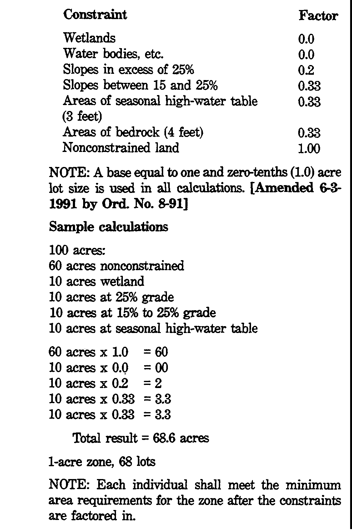
(8) [Added 8-7-89 by Ord. No. 6-89] Constraints calculations and areas, as required in § 90-14H.�
(a) The development of environmentally sensitive lands is to be minimized. The following categories of land are determined to be environmentally sensitive as to impose constraints upon their use:�
[1] Wetlands, as defined in § 90-8F(2)(g).�
[2] Water bodies, watercourses, etc.�
[3] Slopes in excess of fifteen percent (15%).�
[4] Areas of seasonal high-water table with thirty-six (36) inches of the surface.�
[5] Areas of bedrock within four (4) feet of the surface.�
(b) In order that these areas are not developed beyond reasonable densities, the following constraints factors shall be applied in calculating total lots permitted and each lot in a subdivision. No lot size in excess of five (5) non-wetland/water constrained acres shall be required nor shall any resulting lot contain less area than that required in the zone.�
G. Upon submission of a complete application for a subdivision of ten (10) lots or fewer, the Planning Board shall grant or deny preliminary approval within forty-five (45) days of the date of such submission or within such further time as may be consented to by the developer. Upon submission of a complete application for a subdivision of more than ten (10) lots, the Planning Board shall grant or deny preliminary approval within ninety-five (95) days of the date of such submission or within such further time as may be consented to by the developer. Otherwise, the Planning Board shall be deemed to have granted preliminary approval for the subdivision.�
H. If the Planning Board requires any substantial amendment in the layout of improvements proposed by the developer that have been the subject of a hearing, an amended application shall be submitted and proceeded upon as in the case of the original application.�
�
I. Effect of preliminary approval.�
(1) [Amended 6-1-1992 by Ord. No. 15-92] Preliminary approval of a major subdivision shall confer upon the applicant for a period of three (3) years from the date on which the resolution of preliminary approval was adopted all the rights specified in N.J.S.A. 40:55D-49, including the right to apply for extensions thereof as set forth in said section.�
(2) In the case of a subdivision of an area of fifty (50) acres or more, the Planning Board may grant the rights referred to in Subsection I(1)(a), (b) and (c) above for such period of time longer than three (3) years as shall be determined by the Planning Board to be reasonable, taking into consideration the number of dwelling units and nonresidential floor area permissible under preliminary approval, economic conditions and the comprehensiveness of the development. The applicant may apply for thereafter and the Planning Board may thereafter grant an extension to preliminary approval for such additional period of time as shall be determined by the Planning Board to be reasonable, taking into consideration the number of dwelling units and nonresidential floor area permissible under preliminary approval, the potential number of dwelling units and nonresidential floor area of the section or sections awaiting final approval, economic conditions and the comprehensiveness of the development, provided that, if the design standards have been revised, such revised standards may govern.�

