
A.All plats, whether preliminary or final shall be submitted on any one of the following drawing sheet sizes�
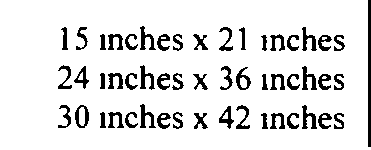
B.All improvement plans and utility plans shall be 24 inches x 36 inches�
C.Drawings shall be prepared at a scale not less than one inch equals fifty feet unless otherwise authorized and guided by the Township Engineer�
A.Minor Subdivisions�
The sketch plat requirements for a minor subdivision shall include the following�
1 Key map showing the subdivision site and its relation to the surrounding area, streets and highways and zone district boundaries�
2 Boundary survey data or tax map data or some other similarly accurate base�
3 Topographic survey of the property and surrounding area within two hundred (200) feet including structures and wooded areas�
4 Existing and proposed drainage features of the property and the surrounding area within two hundred (200) feet (e.g. culverts, marshes, water areas, streams and lands subject to flooding)�
5 Special site conditions such as easements. power lines, and structures�
6 The location of the portion which is to be subdivided in relation to the entire tract�
7 Tax sheet. block and lot number. the name of the owner and all adjoining property owners as disclosed by the most recent Township tax records or those of the adjoining municipalities�
8 All existing and proposed streets. roads and watercourses within the proposed subdivision and those within two hundred (200) feet�
9 All proposed lot lines and lot lines to be eliminated by the proposed subdivision shall be clearly indicated�
10 All existing, proposed, and required setback dimensions�
11 Scale of the plat and north arrow�
12 Area of the entire tract and area of each proposed lot�
13 Lot dimensions, including width at the minimum setback line�
14 Name and address of owner, developer and person preparing the plat 15 Method of sewage disposal.�
B.Major Subdivisions�
The sketch plat for a major subdivision shall include�
1 All the data required for a minor subdivision sketch plat.�
2 Contours at an interval of two (2) feet based on U S G S datum for the property to be subdivided provided that smaller or larger intervals may be used upon approval by the Township Engineer The contours shall extend two hundred (200) feet beyond the subdivision boundary�
3 Relationship to the Master Plan�
4 Any extension of off-tract improvements necessitated by the proposed development�
In addition to the requirements hereinbefore set forth in Sections 9 5 1 and 9 5 2 the Preliminary Plat, Improvement and Utility Plans. and the Final Plat shall conform to the following�
A.The drawings shall be prepared by a licensed professional as required by law�
B.Title Block shall include the following information�
1 Name of the subdivision�
2 Name. address, license number of the professional person who prepared the drawings�
3 The term Preliminary Plat, Improvement and Utility Plans or Final Plat as applicable�
4 Date of the drawing and revisions�
5 Drawing reference number�
6 Section number of the section being subdivided, if applicable�
7 Scale of the drawing�
8 North arrow and/or reference meridian�
C.The title sheet of preliminary or final plat shall show the following additional data�
1 Name and address of developer�
2 Name and address of the owner or owners of record�
3 Total area of the entire tract�
4. Total area of the section being subdivided, if applicable�
5 Total number of proposed lots for the entire tract and for the section being subdivided�
D.There shall be a Key Map which shall show the following�
1 Scale and graphic scale�
2 Relationship of the subdivision to surrounding areas�
3 Boundary lines, building zone districts. special districts and municipal areas�
�
4 Streets and blocks within the subdivision�
E.Lot lines, lot numbers and names of adjoining property owners�
F. If any of the existing structures are on the Historic Landmarks Inventory for Berkeley Heights, maintained by the Union County Planning Board, a notation to that effect shall appear on the plat map�
The Preliminary Plat shall, in addition to the data required in Sections 9 5 1, 9 5 2, and 9.5 3, contain the following data�
A.Existing site conditions to be indicated�
1 Street right-of-way on subdivision and within two hundred (200) feet including: name, location and width, centerline elevations shown on a profile with elevation indicated at a fifty (50) foot interval, and typical cross sections as required�
2 Other rights-of-way and easements on the subdivision and within two hundred (200) feet of its boundaries, including identification and description, location and width, and restrictions of use, if any�
3 Drainage structures or storm sewers and ditches on the subdivision and within two hundred (200) feet of its boundaries to be shown on the plan and profile. including type of structure, location, invert elevations, gradients. and sizes of all pipe and other structures %%here applicable, and capacity of all drainage facilities, including design calculations pertaining to its effectiveness�
4. Location size and capacity of other utility structures, such as water and gas mains and power lines on the subdivision and within two hundred (200) feet of its boundaries�
5 Marshes, ponds, streams and land subject to periodic or occasional flooding or similar conditions on the subdivision and within two hundred (200) feet of its boundaries including location and area covered indicating high water level. water level on date of survey and survey date If any flood plain designated by the N J State Department of Environmental Protection. U S Department of Housing and Urban Development, or the Flood Plain Ordinance of Berkeley Heights. is within two hundred (200) feet of the subdivision. that area shall be so indicated on the plat�
6 Township or other public lands, including lands designated as parks open spaces or for some other public use�
7 Buildings and other structures located on the subdivision or within two hundred (200) feet of its boundaries�
8 Trees having a diameter greater than four (4) inches when measured at a point four (4) feet above the existing grade, except as to Dogwood. Birch or American Hombeam trees, the diameter of which shall be two (2) inches when measured at a point four (4) feet above the ground, located on the subdivision except that where trees are in mass only the limits thereof need be shown, except that if the trees are proposed to be removed, trees over nine (9) inches in diameter shall be individually indicated�
B.Proposed site conditions to be indicated�
1 Streets�
a Right-of-way width�
b Centerline elevations of fifty-foot intervals shown on the profile sheet�
c Centerline gradient shown in percent of slope�
d Street surface contours at two-foot intervals�
e Cross sections at a minimum of one hundred foot intervals�
f Street names�
2 Lot layout�
b Building setback lines (dashed) and its dimensions from the lot line�
c Easements and restricted areas with notation as to purpose or restriction�
d Identification of lots or parcels for special uses, whether they are to be offered for dedication or not�
e Future layout for all reserved parcels, in broken lines, in conformance with existing zoning regulations�
f High points and low points shown on the plan and profiles. with elevations thereof shown on profiles�
g An analysis of allowable sight distance at all intersections and indicated on the plat map and location of sight triangles�
3 Preliminary storm water drainage plan as set forth in Part 12�
4 All existing trees as defined in the Tree Ordinance of Berkeley Heights to be removed within the subdivision shall be so noted�
5 Proposed sanitary sewer system in plan and profile�
a All proposed sanitary sewers with sizes and gradients�
b All proposed pumping stations, force mains and other special facilities�
6 Tentative location and size of all other proposed utilities�
7 Proposed tentative grading plan, indicated by contours at two-foot intervals or other intervals as may be required by the slope and nature of the final grading for the entire subdivision�
A.In order to insure that the Environmental Impact Statement is competently prepared, the applicant shall provide written information to the Planning Board regarding the qualifications of its author The Environmental Impact Statement is a separate written description and analysis of all direct and indirect effects the proposed development will have on the site, the adjacent areas and all other areas with particular reference to the effect of the proposed development on the public safety, health and general welfare, the protection of public and private property and protection, preservation and enhancement of the natural environment�
B.Data required The Environmental Impact Statement shall contain information and analysis regarding the following�
1 The location and description of the development�
2 An inventory of existing environmental conditions of the site, adjacent areas and all other affected areas which describe contours, air quality. water quality water supply, hydrology, geology, soils, topography. vegetation. wildlife. ecology, demography. land use, and aesthetics�
3 A listing of all licenses. permits, or other approvals required by Municipal, County or State laws and status of each�
4 An assessment of the probable impact of the development, both adverse and beneficial on the inventory described in Section 9 5 5 B 2�
5 The environmental effects on the following shall be described in detail�
a Water quality�
b Air quality�
c Noise�
e Significant plant or wildlife systems�
f Aesthetic values�
g Natural resources�
h Landscaping�
i Lighting patterns and glare�
j Man-made resources�
k Community and regional growth�
l Traffic�
6 A description of steps to be taken during and after construction to reduce adverse effects described in Section 9 5 5 B 5�
7 Data regarding sewerage facilities, water supply. drainage as described in Part 12, air pollution, and solid waste disposal�
�

