
Any deviation from standards of this Plan that result in a "d" variance pursuant to NJSA 40:55D-70d shall be addressed as an amendment to the Plan by the Township Council rather than via variance relief through the Township Zoning Board of Adjustment. "C" variance relief pursuant to section NJSA 40:55D-70c may be addressed by the Planning Board through the development application process. All development must be approved by the Township Planning Board and shall be submitted through the normal site plan and subdivision procedures as identified by NJSA 40:55D, et seq.
2. District Standards
The following District Standards contain information pertaining to the development objective of the parcel, the permitted and accessory uses therein, and the parcel-specific design standards. The general, Area-wide design standards contained in the General Design Standards section below, apply to all districts. In addition to the more specific standards provided in this section, also included is the vision statement of the district. This statement serves to guide the prospective developer to achieve what the Township envisions for the specific area in terms of types of uses and design. Developers are encouraged to align their development proposal(s) for their property with the overall vision of the parcel and the Area as a whole. The standards for the development districts are as follows:
3. Senior Housing
a. Redevelopment Objective: To utilize existing underutilized land to provide affordable independent and assisted-living housing opportunities to senior citizens. The tract of land between Oak Place and Pine Street has been provided to meet this objective due to Its location adjacent to Williams Park and its Proximity to the Suburban Bus Lines operation across Route 27. The senior housing is envisioned to be low-rise in styles such as townhouses, garden apartment of other creative designs. Building orientation toward the park mid physical linkages.
Williams Park via pathways are encouraged. In order to facilitate ingress and egress to and from the parcel, access is recommended only from adjoining local roads and not Route 27.
b. Principal Permitted Uses:
(1) Independent Senior Housing
(2) Assisted-Living Facility
(3) Public Use
c. Accessory Uses:
Customary, incidental and accessory to the principal use.
d. Standards for Independent Housing:
(1) Minimum lot area: 5 acres
(2) Maximum density: 8 units per acre
(3) Maximum height: 35 feet
(4) Maximum lot coverage: 55 percent
e. Standards for Assisted-Living Facility.
(1) Minimum lot area shall be 3.5 acres; the tract can be separated by a public right-of-way.
(2) Maximum height: 40 feet
(3) Maximum lot coverage 75 percent
f. Standards for Public Use:
(1) Minimum lot area: 20,000 square feet
(2) Maximum height: 35 feet
(3) Maximum lot coverage: 55 percent
g. General Standards:
(1) Minimum setbacks: 50 feet along Route 27; 25 feet along Parkside Street and Matilda Avenue; 10 feet along Naaman Williams Park.
(2) Ingress and egress to/from the site shall not be provided onto Route 27.
(3) A physical link-age interconnecting the site and Naaman Williams Park shall be encouraged
(4) Accessory structures shall not exceed a height of 15 feet and shall comply with the setback standards for principal uses.
4. Infill Residential
Redevelopment Objective: This district Currently contains stable residential neighborhoods and has been designated for in-fill of single family and two-family residential uses on vacant lots and maintenance of existing, intact housing. New development in this area is encouraged to coordinate with the existing pattern and appearance of development.
a. Principal Permitted Uses:
(1) Single- and Two-Family Residential
(2) Public Use
b. Accessory Uses:
Customary, incidental and accessory to the principal use.
c. Standards:
(1) Minimum lot area for single-family structures: 5,000 square feet
(2) Minimum lot area for two-family structures and public use: 7,500 square feet
(3) Minimum lot frontage for single-family structures: 50 feet
(4) Minimum lot frontage for two-family structures and public use: 75 feet
(5) Minimum lot depth: 100 feet
(6) Maximum height: 35 feet
(7) Minimum setbacks for principal structures:
(8) Front yard: 25 feet
(9) Side yard (each): 8 feet
(10) Rear yard: 25 feet
(11) Maximum lot coverage for one- and two-family residential use: 30 percent
(13) Accessory structures and uses shall be governed as per the Development Ordinance of the Township of Franklin.
5. Gateway Commercial
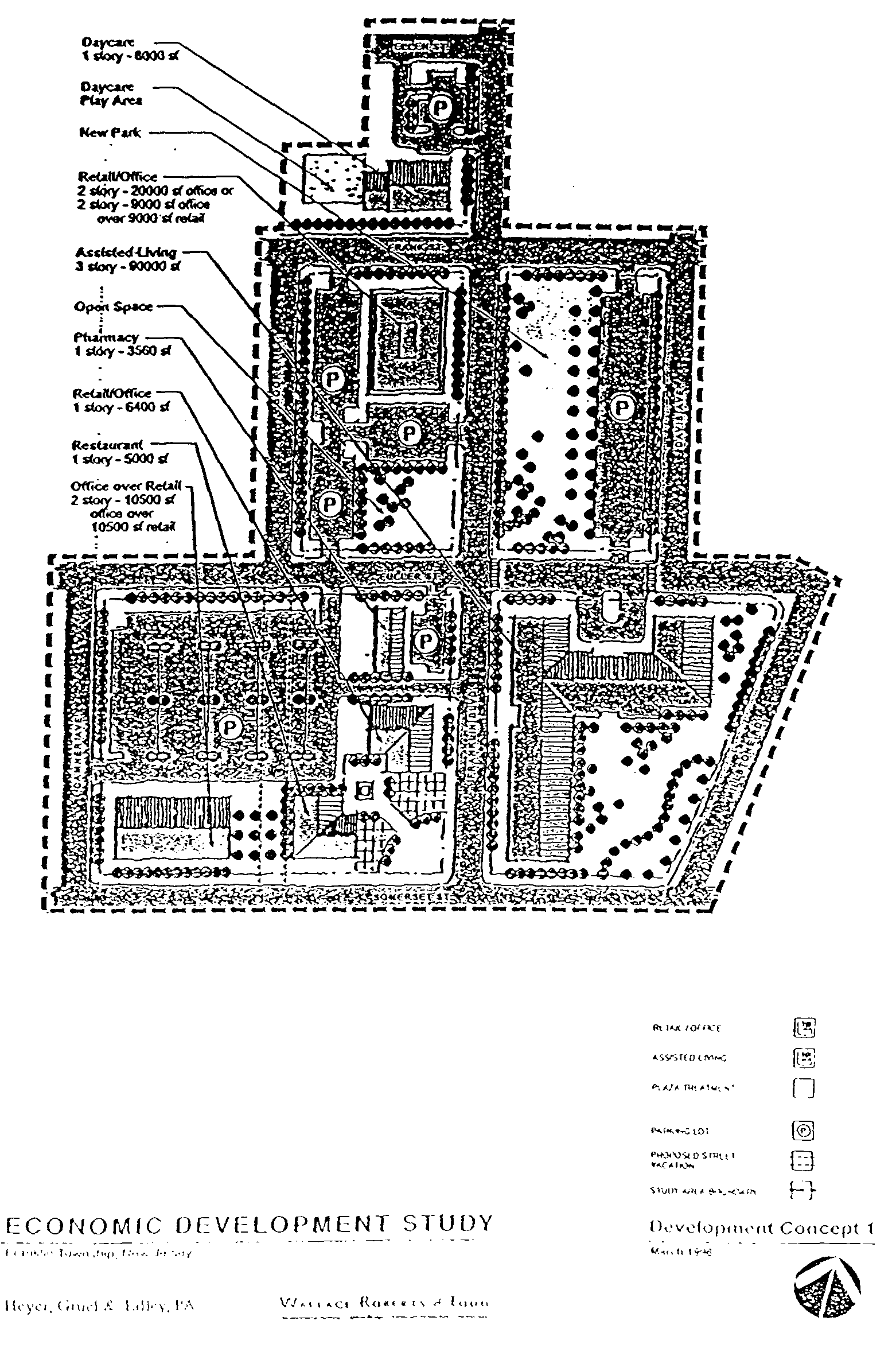
a. Redevelopment Objective: This area is intended to be the "gateway," or focal point of the Redevelopment Area in Franklin Township. This area, at the intersection of Route 27 and Franklin Boulevard (Blocks 122 and 128-132), was the subject of an Economic Development Study completed in 1997. It was determined that this area, due to its locational prominence, is the cornerstone of the Redevelopment Area in the Township and should be redeveloped for retail, family-style restaurant (non drive-thru), office, day care and assisted-living facility (ALF). Target blocks for each of these uses were identified in the study, and a Concept Plan for the area was created (see Concept 1). Early on in the conceptualization process, it was determined that site plans for the area should be neo-traditional in design, with attention paid to streetscapes, pedestrian orientation and architectural. details. Effectively, this means bringing buildings closer to the street and providing parking toward the rear of parcels. The entrances to the shops are recommended to be from the parking area, although access ways to the buildings can also be provided from the public sidewalk. The buildings should not turn a blank rear wall toward the street, either; there can be window displays and other architectural treatments on these rear walls. Architectural details such as pitched roofs to enhance the presence of one-story buildings and facade and signage standards are recommended for this area. These changes will fundamentally improve the appearance and character of the area. Outdoor dining in plaza areas is also recommended. Because this area is a gateway, it is recommended that design standards across Route 27 in New Brunswick be modified to complement the standards set forth herein.
b. Principal Permitted Uses:
(1) Retail including restaurant (non-drive thru)
(2) Office
(3) Financial Institution
(4) Day Care Center
(5) Assisted-Living Facility
(6) Public Use
c. Accessory Uses:
Customary, incidental and accessory to the principal use, including outdoor dining.
d. Standards:
(1) Minimum lot area: 20,000 square feet
(2) Minimum lot frontage: 100 feet
(3) Minimum lot depth: 100 feet
(4) Setbacks:
Front yard: Maximum 20 feet
Side yard (each): 20 feet
Rear yard: 20 feet
Maximum lot coverage: 75 percent Maximum height: 35 feet
e. Standards for Assisted-Living Facility:
(1) Minimum lot area shall be 3.5 acres; the tract can be separated by a public right-of-way.
(2) Minimum setback requirements: 25 foot perimeter setback
(3) Maximum height: 40 feet
(4) Required open space/parkland: 15 percent of parcel area
f. General Standards:
(1) On blocks along Franklin Boulevard, buildings shall be oriented along the Franklin Boulevard and Route 27 frontages, except in the case of the Assisted-Living Facility, which shall front on Fuller Street. Main entrances for retail/office structures can be established toward the interior of the site and the parking areas if access ways from the roadside sidewalk to those entrances are provided.
(2) On blocks along Franklin Boulevard, a design theme shall be established for this area which shall 'incorporate compatible facade treatments and textures, sidewalk and streetscape improvements, roof pitches and textures and signage to ensure consistency among these blocks and within the Redevelopment Ai-ea.
(3) Accessory buildings shall not be located in the front yard and shall have 10-foot minimum yards.
(4) Accessory structures shall not exceed a height of 15 feet.
6. Renaissance Commercial
a. Redevelopment Objective: The objective of this district is to revitalize the commercial properties and activity in the area by providing opportunities for existing property owners to continue and upgrade their properties as well as for redevelopment of the properties by redevelopers. Meeting this objective requires design flexibility, which has been provided by tiering the standards for properties in this district by lot size. Larger-scale uses generally require more screening, more landscaping, wider setbacks and less lot coverage. Smaller-scale uses, on the other hand, are generally less obtrusive and so require less in terms of buffering and setbacks. Larger-scale uses are desired on several target blocks within the area. They are: Blocks 171.02, 166, 164, 163, and 152. In addition, the existing office condominiums on Block 171.02, Lot 237.03 at the corner of Henry Street and Route 27 have been targeted for adaptive reuse as potential residential uses.
b. Principal Permitted Uses:
(1) Retail including restaurant
(2) Office
(3) Financial Institution
(4) Public Use
(5) Adaptive reuse of existing off-ice condominium structures.
c. Accessory Uses:
Customary, incidental and accessory to the principal use, including outdoor dining.
d. Standards for Lots Less Than 20,000 Square Feet in Area:
(1) Minimum lot frontage: 100 feet
(2) Minimum lot depth: 100 feet
(3) Setbacks:
(4) Front yard: Minimum 15 feet; maximum 25 feet
(5) Side yard (each): Minimum 10 feet
(6) Rear yard: Minimum 40 feet
(7) Maximum lot coverage: 85 percent
(8) Maximum height: 35 feet
e. Standards for Lots Greater Than 20,000 Square Feet in Area:
(1) Minimum lot frontage: 100 feet
(2) Minimum lot depth: 100 feet
(3) Setbacks:
Front yard: Minimum 20 feet; maximum 40 feet
Side yard (each): Minimum 15 feet
Rear yard: Minimum 40 feet
Maximum lot coverage: 75 percent
Maximum height: 35 feet
f. Standards for Blocks Along Franklin Boulevard:
(1) Minimum lot area: 20,000 square feet
(2) Minimum lot frontage: 100 feet
(3) Minimum lot depth: 100 feet
(4) Setbacks:
Front yard: Maximum 20 feet
Side yard (each): 20 feet
Rear yard: 20 feet
Maximum lot coverage: 75 percent
Maximum height: 35 feet
g. Standards for Permitted Adaptive Reuse: [Amended 7/10/01 by Ord. No. 3232]
(1) Minimum lot size: 1.5 acres
(2) Maximum density: 19 units per acre
(3) Minimum setbacks: 20 foot perimeter setback
(4) Maximum lot coverage: 60 percent
(5) Maximum height: 35 feet
h. Accessory Structure Standards:
(1) Accessory buildings shall not be located in the front yard and shall have 10-foot minimum yards.
(2) Accessory structures shall not exceed a height of 15 feet.
7. Commercial/Industrial
a. Redevelopment Objective: To fill in the existing underutilized industrial area with larger-scale commercial uses and manufacturing and warehousing/distribution uses to create a more cohesive light industrial area. Special attention should be paid to those uses that front on Route 27 and residential streets, namely Blair Avenue. This can be accomplished by limiting the types of uses that front on Route 27 and can also occur through wider setbacks and screening of those uses which require outdoor storage.
**Webmasters Note: The previous subsections, I.6.d through I.7.a, have been amended as per the 2001 Supplement.
b. Principal Permitted Uses Fronting on Route 27 and Blair Avenue:
(1) Retail including restaurant, entertainment, commercial recreation, car wash, gasoline service station
(2) Office
(3) Financial Institution
(4) Public Use
C. Principal Permitted Uses Fronting on Local Roadways (Excluding Blair Avenue):
(1) Auto repair (not including automotive junkyards)
(2) Wholesale distribution, including lumber yards
(3) Contractor storage/staging
(4) Manufacturing and warehousing/distribution in compliance with performance standards as per Township Ordinance
d. Accessory Uses:
Customary, incidental and accessory to the principal use, including outdoor dining.
C. Standards.
(1) Minimum lot area: 10,000 square feet
(2) Minimum lot frontage: 100 feet
(3) Minimum lot depth: 100 feet
(4) Minimum setbacks:
(5) Front yard: 50 feet
(6) Side yard (each): 20 feet
(7) Rear yard: 25 feet
(8) Maximum lot coverage: 75 percent
(9) Maximum height: 50 feet
(10) Screening for uses not permitted to front on Route 27 that contain Route 27 frontage: Those lots that have frontage on Route 27, but are required to be oriented and accessed along local roadways, shall provide a minimum 20-foot wide screened buffer along their Route 27 frontage of sufficient height and massing to screen the activities occurring on the site from the Route 27 view corridor.
(11) Landscaping shall be provided along Blair Avenue to shield on-site structures and activities to the extent possible.
(12) Accessory structures shall comply with the standards for principal structures.
8. Office/Professional
a. Redevelopment Objective: To provide a location for appropriate uses along the Hamilton Street corridor in the Area. This district is envisioned to contain office/professional buildings of up to three (3) stories in height that Will provide a transition from the more office and residentially oriented portion of Hamilton Street to the commercial node at Franklin Boulevard/Hamilton Street intersection.
b. Principal Permitted Uses.(1) Office
(2) Financial Institution
(3) Existing Residential Use
(4) Public Use
C. Accessory Uses:
Customary, incidental and accessory to the principal use, including parking and loading and signs.
d. Standards:
(1) Minimum lot area: 10,000 square feet
(2) Minimum lot frontage: 100 feet
(3) Minimum lot depth: 100 feet
(4) Maximum height: 40 feet for office use; 35 feet for residential use.
(5) Minimum setbacks:
Front yard: 35 feet
Side yard (each): 20 feet
Rear yard: 25 feet
Maximum lot coverage- 55 percent for office use; 30 percent for residential use.
Office uses shall be permitted access only onto Hamilton Street.
Accessory structures and uses shall be governed as per the Development Ordinance of the Township of Franklin.
9. Public/Institutional Use
a. Redevelopment Objective: To retain existing public and Institutional uses in the Area. These existing uses are permitted to remain and expand within the parameters of the standards set forth herein. The Board of Education property on Hamilton Street was programmed in the Renaissance 2000 plans to contain a new entrance to the High School and to potentially contain athletic fields.
b. Principal Permitted Uses:
(1) Public or Institutional Use
(2) Houses of Worship
(3) Parks and Open Space
(4) Public Housing
(5) Existing Residential Use
C. Accessory Uses:
Customary, incidental and accessory to the principal use, including office, parking and loading and signs.
d. Standards for Existing Residential
(1) Minimum lot area for single-family residence: 7,500 square feet
(2) Minimum lot area for two-family residence: 10,000 square feet
(3) Minimum lot frontage for single-family structures: 75 feet
(4) Minimum lot frontage for two-family structures: 100 feet
(5) Minimum lot depth: 100 feet
(6) Maximum height: 35 feet
(7) Minimum setbacks:
Front yard: 25 feet
Side yard (each): 10 feet
Rear yard: 20 feet
(8) Maximum lot coverage: 30 percent
e. Standards for Public Housing:
(1) Minimum lot area: I acre (can be divided across a public right-of-way)
(2) Maximum height: 35 feet
(3) Minimum setbacks: 20 foot perimeter setback
f. Standards for Houses of Worship:
(1) Minimum lot area: 3 acres
(2) Minimum setbacks: 25 foot perimeter setback
(3) Maximum number of stories: 35 feet
(4) Maximum height: 50 feet
(5) Maximum lot coverage: 60 percent
g. Standards for Accessory Structures:
Accessory structures and uses shall be governed as per the Development Ordinance of the Township of Franklin.
J. GENERAL DESIGN STANDARDS
This section details the overall design standards for the Area in terms of streetscape design, open space and landscaping design, building design, off-street parking and circulation and outdoor dining. These standards are to be used in conjunction with the Parcel Standards. Any deviation from these standards should be considered by the Planning Board and may be granted as a design waiver- It is recommended that these standards be implemented via ordinance beyond the Redevelopment Area throughout (lie Renaissance 2000 area in both Franklin Township and the City of New Brunswick to create design consistency throughout the Renaissance 2000 area.
1. Streetscape Requirements
The streetscape is the primary image-setting area and includes all public and private streets. The aesthetics of this area, therefore, are extremely important. The following standards should be considered in streetscape design of this area:
a. Deciduous street trees should be planted 40-foot on-center. Trees shall be over 12 feet in height with a minimum 3-inch caliper (dbh) and shall be planted on the property-side of any sidewalk.
b. Trees shall be planted in a minimum 5-foot-wide lawn area or shall be planted in a continuous trench with tree grates.
2. Open Space Design and Landscaping
The goal of the open space design standards is to improve the visual environment of the area through landscaping and other amenities in order to attract people to the Area. People are naturally attracted to areas that appear inviting, comfortable and safe. The following standards have been created to achieve this goal.
a. All areas not covered by building, pavement or other impervious surface shall be landscaped by a mix of evergreen and deciduous trees, shrubbery and herbaceous plants, including grass.
b. Open spaces shall be so located as to provide for maximum usability, while also taking public safety into consideration, and to create a harmonious relationship between buildings and the open Space throughout the Area.
c. All improved open space shall incorporate elements such as shrubbery, attractive paving materials, street furniture, lighting, low walls, fountains, and other architectural and artistic amenities so as to produce and provide a pleasant environment at all levels.
d. All plantings shall be with species proven to resist the urban environment in this area. Evergreen screen planting shall be a minimum of four (4) feet in height. Deciduous planting shall be a minimum of three (3) feet in height. Material shall be planted, balled, and burlapped and be of specimen quality as established by the American Association of Nurserymen. At initial planting said material shall provide a screen from the top of the planting to within six (6) inches of grade. Other plant materials shall be dense and of specimen quality as determined above. All deciduous trees shall be a minimum of three (3) inches in caliper (dbh).
e. Indoor and/or outdoor plazas shall be encouraged. Adequate landscaping and street furniture of a style complementary to the surrounding facades shall be used.
f. Design emphasis on gateways and major access points shall be encouraged. Gateways shall be marked by walls, signage, graphics, landscaping, buffering, distinctive street lighting, monuments, street furniture, paving accents, flags, and/or banners.
g. All fences and walls shall be designed as integrated parts of the overall architectural and site design. All materials shall be durable and finished in textures and colors complementary to the overall architectural design.
h. Conspicuous chain link fencing without screening and/or landscaping shall not be permitted.
1. Sidewalk areas shall be landscaped and durably paved and shall be properly illuminated with safe and adequate cutoff lighting.
j. Maintenance of landscaping on public property or rights-of-way may be the subject of a Developer's Agreement.
k. All utilities shall be located underground.
3.. Building Design
When buildings in an area are of similar and/or compatible scale, materials and massing, the area becomes more harmonious, thereby providing a more comfortable human experience. The Building Design standards section seeks to achieve a continuity of design that allows for individuality of design while still providing a distinct identity for the Area. The following standards have been created to achieve such goals:
a. All structures within the Redevelopment Area shall be situated with proper consideration of their relationship to other buildings, both existing and proposed, in terms of light, air, and usable open spaces, access to public rights-of-way and off-street parking, height, and bulk.
b. Groups of related buildings shall be designed to present a harmonious appearance in terms of building silhouette, architectural style and scale, massing of building form; surface material, finish, and texture decorative features; window and doorway proportions, entry way placement and location, signage, and landscaping.
c. Buildings shall be designed so as to have attractive, finished appearances from all public spaces.
d. Buildings that are to be only one story shall have roof pitches of at least 45 degrees to enhance the presence of the building, where feasible.
4. Signage
a. Standards for signage are important to coordinate the appearance of the Route 27 corridor. Although Route 27 is a State highway, it is intended for the corridor to retain the character of a local roadway, where controlled speed and pedestrian access and safety are priorities. Therefore, signage is recommended to be appropriately scaled--smaller in surface area and height. The following standards apply to various potential uses in the Redevelopment Area:
b. The following design standards apply to signage on all parcels:
(1) Signage shall create a sense of aesthetics, originality and order. It shall be legible and dimensionally proportional
(2) Signs shall be restricted to tenant identification and directional signs, either wall-mounted or freestanding.
(3) No rooftop signs shall be permitted.
(4) Signage shall be oriented toward (lie roadway that directly accesses (the Property.
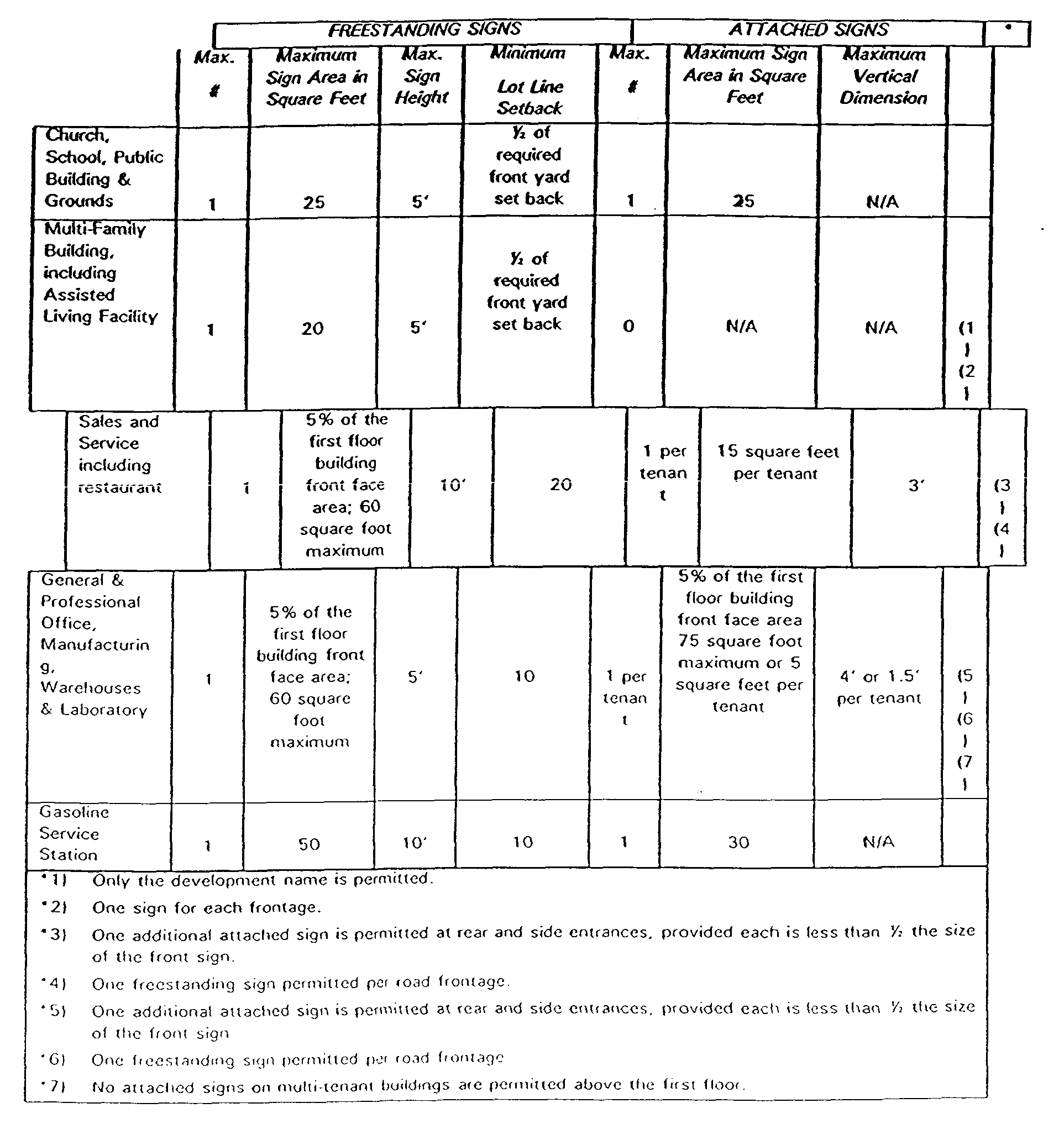
(5) Signs visible from the exterior of any building, if illuminated, shall be internally illuminated without a halo, but no signs or any other contrivances shall be devised or constructed so as to rotate, gyrate, blink, move or appear to move in any fashion.
(6) Public service devices such as clocks and temperature indicators shall be devoid of advertising.
(7) Directional signage shall be sized as per industry standard.
5. Off-Street Parking and Circulation
a. Off-street parking is an integral component of the Plan. The importance of such parking, however, is not intended to dictate project design. Off-street parking is encouraged to be as inconspicuous as possible and to incorporate landscaping and screening to the greatest extent possible to minimize 'its physical and visual impact. The Residential Site Improvement Standards, as amended, shall apply where applicable.
b. Minimum Off-Street Parking Standards - Each parcel and use Is required to provide minimum off-street parking in accordance with the following schedule:
(1) Assisted-Living Facility: one-half (0.5) spaces per unit
(2) Day Care Center: 1.5 spaces per employee
(3) House of Worship: I space for each 3 seats
(4) Light industrial/distribution/warehousing: 1 space per 1,000 square feet of building area
(5) Office: I space per 300 square feet of gross floor area.
(6) Restaurants: I space per 3 seats
(7) Retail/commercial recreation/entertainment: I space per 250 square feet of gross. floor area
(8) No parking shall be located between the building and the roadway right-of-way.
(9) Off-street parking and loading areas shall be coordinated with the public street system serving the Area in order to avoid conflicts with through-traffic, obstruction to pedestrian walks, and vehicular thoroughfares. Shared parking among mixed uses shall be encouraged and may be factored in for purposes of calculations.
(10) A minimum of ten (10) percent of any surface parking facility shall be landscaped and shall include one (1) shade tree for every twenty (10) parking spaces. The perimeter of the parking area shall be landscaped. Large be avoided concentrations of surface parking shall whenever possible.
(11) All parking and loading areas shall be landscaped about their periphery with shrubs, trees, and/or ground cover.
(12) All ninety (90) degree parking spaces shall be a minimum of nine (9) feet in width by eighteen (18) feet in depth. Aisles shall be a minimum of twenty-six (26) feet in width.
(13) The relationship between truck delivery, vehicular traffic, and pedestrian circulation shall be considered when designing service entries, roadways, walk-ways, and pedestrian entrances.
(14) Sidewalks shall be designed to be part of a comprehensive system to access all facilities within the Area.
(15) Sidewalks shall be a minimum of four (4) feet in width, exclusive of car overhang areas, and shall be set back, a minimum of five (5) feet from all buildings.
6. Storage, Service, and Loading Areas
a. Storage, service, maintenance, and loading areas shall be constructed, maintained, and used in accordance with the following conditions:
b. One (1) on-site loading space shall be provided per building. For buildings with more than 25,000 square feet of gross floor area, one additional loading space for each additional 15,000 square feet of gross floor area thereafter shall be required.
c. Loading areas are permitted in rear yards, centralized courtyards, side yard or areas, provided that they are screened from public view.
d. No loading, storage or service area shall be located between the building line and the street line.
e. Service entrances and loading areas between adjacent buildings shall be consolidated and separated from walkways and pedestrian entrances to the extent possible.
f. No materials, supplies, or equipment, including trucks or other motor vehicles, shall be stored upon a site except inside a closed building or behind a durable material wall not less than six (6) feet in height screening such materials, supplies, or vehicles from adjacent sites so as to be screened from neighboring properties and streets. In no case shall materials stored outdoors exceed a height of eight (8) feet.
g. Any outdoor storage areas shall be located within the rear portions of a site. No storage areas may extend into a setback area.
h. Provisions shall be made on each site for any necessary vehicle loading, and no on-street vehicle loading or idling shall be permitted.
7. Refuse and Recycling Collection Areas
a. All outdoor refuse and recycling containers shall be visually screened within a durable enclosure, six (6) feet or higher, so as to be screened from adjacent lots or sites, neighboring properties or streets. No refuse and recycling collection areas shall be permitted between a street and the front of a building.
b. Refuse and recycling collection enclosures be designed of durable materials with finishes and colors which are unified and architectural theme.
c. Refuse and recycling collection areas should be so located upon the lot as to provide clear and convenient access to refuse collection vehicles.
d. Refuse collection area should be designed and located upon the lot as to be convenient for the deposition of refuse generated on-site.
e. Refuse and recycling collection areas should be effectively designed to contain all refuse generated on site and deposited between collections. Deposited refuse should not be visible from outside the refuse enclosure.
8. Screening of Exterior Mechanical Equipment
a. in areas where rooftops can be viewed from adjacent roadways, rooftop equipment shall be screened to the greatest extent possible either via painting it to match the roof or facade, or by creating rooftop screening devices.
b. Conventional mechanical and electrical equipment which is part of the building space, heating, ventilating and air conditioning system, lighting and general power, or process equipment where ground mounted shall be screened from view with evergreen landscaping or screen walls that match the principal building.
c. Electrical equipment shall be mounted on the interior of a building wherever possible. When interior mounting is not practical, electrical equipment shall be mounted in a location where it is substantially screened from public view. In no case shall exterior electrical equipment be mounted on (fie street side or primary exposure of any building
9. Outdoor Dining
a. Where permitted, temporary outdoor dining as an accessory use to a restaurant shall be permitted under the following provisions:
b. Restaurants shall not place any table, sign, umbrella, or other item in such a manner as to block any walkways or building entrance/egress, municipal signs, receptacles for garbage, public benches, or other public amenity including fire hydrants.
c. Restaurants must provide for the disposal of recyclable cans/bottles and garbage. Public receptacles for garbage shall not be used.
Sidewalk areas shall be kept clean during hours of operation.
d. No portion of any sidewalk dining equipment, including chairs, tables, and opened umbrellas shall encroach upon the sidewalk or in a manner to block, impede or cover adjacent store fronts, doors, or windows in front of other business establishments.
K. PLAN OF ACTION
1. Relationship Between Franklin Township and First Baptist CDC
The Township anticipates creating an independent seven-member Redevelopment Agency, headed by an Executive Director. The seven member Agency will be selected by the Township Mayor and Council and will be comprised of Township residents. The Redevelopment Agency request approval of the Agency through the Local Finance Board after the Plan has been adopted. The Agency will assist the Township in implementing elements of the Plan. It is further anticipated that the First Baptist CDC Human Services element will, at a minimum, be called upon to consult with the Agency on prospective developers and development applications. The independent housing and economic development branches of the First Baptist Church will continue to serve as potential developers within the Redevelopment Area.
2. Development Schedule
The redevelopment of the Area is anticipated to occur in multiple phases with more than one developer. The Township has identified the redevelopment of the Route 27/Franklin Boulevard area as a priority because it serves as a gateway into Franklin Township and can be a real catalyst for change in the Area. The Township received Somerset County grant monies to fund the Request for Qualifications/Request for Proposal process for this six block area to jumpstart its redevelopment.
3. Property To Be Acquired
It Is a goal of the Township to minimize the number of displacements caused by Area redevelopment. This Redevelopment Plan requires displacement in only limited areas, and promotes private development via infill and reuse for the majority of the Area. In cases where property must be acquired, this Plan authorizes the Township to exercise its condemnation powers on all properties in the Redevelopment Area, to acquire property or to eliminate any restrictive covenants, casements or similar property interests which may obstruct the implementation of the Plan.
4. Relocation it is anticipated that relocation will be required only in limited areas within the Redevelopment Area. Franklin Township will provide all displaced tenants and landowners with the appropriate relocation assistance, pursuant to applicable State and Federal law, should relocation be necessary. Such assistance will be provided through an appropriately designated office which will assist in any relocation of persons, businesses or other entities. The local housing market, including Franklin and surrounding communities, contains an ample supply of comparable replacement housing to absorb the residents of Franklin who may be displaced by the redevelopment process. Further, Franklin and the surrounding area contain sufficient land and buildings which would be appropriate for relocation of existing businesses from the Redevelopment Area. If relocation is not directly caused by the Redevelopment Plan, the Township assumes no responsibility for relocation of people and businesses.
5. Incentives And Project Funding
The Renaissance 2000 area has an established history of receiving and distributing grant and loan monies to various development projects in the area, The following entities have been identified which currently or can potentially provide technical expertise and/or financial incentives to redeveloper(s). The location of the Redevelopment Area in an Urban Coordinating Council Neighborhood increases the likelihood of redevelopment project funding and financing assistance of these entities. This list highlights the key resources which can be coordinated to maximize the leveraging of private investment.
a. Renaissance 2000 Affordable Housing Program - Administered by CDC Properties, Inc., uses HOME funds to rehabilitate and resell single-family homes.
b. New Jersey Economic Development Authority - NJ EDA offers an array of programs and services for businesses seeking to locate, expand and remain in New Jersey.
c. The Investment Banking Division offers long-term, lower interest rate bond financing of $750,000 and greater for a wide range of businesses and not-for-profit organizations. Tax-exempt bond financing is available for qualified borrowers such as manufacturing facilities and certain non-profit (501)c(3) organizations.
d. The Community Development and Small Business Lending Division offers financial assistance and technical assistance (including training programs and consultations) for start-up and micro-businesses.
e. The Commercial Lending Division offers loans and loan guarantees from $50,000 to $3 million targeted to small and middle-market businesses. Programs offered include, in conjunction with NJDEP, assistance to companies involved in hazardous discharge site investigation and clean-up with loans up to $1 million for up to 10 years. Municipalities may apply for grants and loans up to $2 million per year.
f. The Real Estate Development Division provides assistance with land assembly, site improvements, construction and renovations for projects of significant economic impact.
g. NJ EDA also offers tax exempt bonds, the Business Incentive Program, financing through the Urban Development Corporation (UDC) and administers the Local Development Financing Fund.
h. New Jersey Office of Sustainability - NJOS has been given the authority by the State to provide low interest loan funds to qualified sustainable businesses, to encourage the state's procurement of environmentally preferable products and to act as an advocate for sustainable firms.
1. US Economic Development Authority - US EDA offers a variety of programs and services including infrastructure financing.
j. New Jersey and US Small Business Administrations - SBAs offer competitive loans to qualified small businesses.
k. US Department of Housing and Urban Development - HUD provides Community Development Block Grant (CDBG) monies which can be used in a number of different ways, and has recently developed an Economic Development Initiative Program.
l. Housing Programs
(1) Federal loan and mortgage guarantees through the Federal Housing Administration (FHA) and Federal National Mortgage Agency (FNMA)
(2) Federal Home Loan Bank (FHLB) Affordable Housing Program
(3) Veterans Administration mortgage guarantees
(4) Federal Low-Income Housing Tax Credits
(5) New Jersey Housing and Mortgage Finance Agency (HMFA) bond financing and reduced rate mortgages
(6) New Jersey Department of Community Affairs (NJ DCA) HOME funding, Balanced Housing Program and Housing Advocacy Pre-Development Grants.
m. Private foundations
(1) Transportation Improvement Funds - The New Jersey Department of Transportation and New Jersey Transit, under the federal. Transportation Equity Act for the 21" Century, provide grants for various transportation projects that improve safety, increase intermodality, protect the environment and create economic opportunity. These programs include:
(2) Transportation Enhancement grants for transportation projects that improve communities' cultural, aesthetic and environmental qualities
(3) The Sustainable Communities program establishes a pilot program to help state and local governments plan environmentally-friendly development
(4) Bicycle and Pedestrian Paths programs expand funding provisions to make bicycling and walking safer and more viable ways of travel.
(5) NJDEP Green Acres Program - This program is administered by the NJDEP Bureau of Green Trust Management, and provides low interest (2 percent) loans and grants to municipal and County governments to acquire open space, develop outdoor recreation facilities and to finance conservation, including historic preservation, efforts.
(6) Payments in Lieu of Taxes (PILOTs) - PILOTs incentives for developers can be considered by the municipality.
(7) NJDEP Brownfields Program - This program is run through the Site Remediation Program and was created to promote reuse of contaminated properties by providing guidance for conducting investigations and clean-ups funding for municipalities and businesses to conduct the work through the Hazardous Discharge Site Remediation Fund and by clarifying liability issues for local officials, developers and the leading community. NJ EDA administers the financial aspect of the site remediation in connection with the Hazardous Discharge Site Remediation Fund, while NJDEP administers the site remediation aspects of applications to the fund
(8) US EPA Brownfields Program - This program is currently in its Pilot Projects stage, and has given grant money for assessment projects such as the one in Hudson County, and has also given grant money for remedial work in federal Urban Empowerment Zones, such as the City of Newark and the City of Camden. Additionally, federal legislation is pending that will alto", federal income tax credits for reclamation costs of Brownfields areas.
(9) NJDEP Underground Storage Tank Removal Program Provides funding and technical guidance for removal of leaking and substandard USTs.
(10) NJDEP Environmental Opportunity Zones - A statute enacted in January 1996 allows municipalities to create "Environmental Opportunity Zones" where local property tax incentives will be provided during a 10-year period to developers of contaminated properties within the designated areas.
PLAN RELATIONSHIP TO DEFINITIVE LOCAL OBJECTIVES
1. Franklin Township Master Plan
The objectives of the Plan seek to achieve the goals and objectives contained within 1994 Master Plan Reexamination which update the goals and objectives of the 1988 Township Master Plan. The following goals of the 1994 Master Plan Reexamination are met by the Redevelopment Plan:
a. Maintain diversity in the type and character of development and particularly to promote opportunity for varied residential environments and variety in the type and cost of housing:
(1) By providing a variety of housing choices in new developments within overall density standards as expressed in the Land Use Element with due consideration of the and this Circulation environmental preservation policies Element contained herein
(2) By providing housing for varying age groups, family sizes and income levels;
(3) By protecting sound residential areas and upgrading those that are in declining condition;
(4) Explore other than the Builder's Remedy/ conventional developer set asides as means of providing affordable housing.
(5) Conserve rural characteristics, areas of natural beauty, sensitive environmental areas, productive agricultural areas and important historic places.
(6) Expand the employment base and tax base, focusing on areas with regional accessibility to avoid traffic and other transportation problems:
(7) By relating major employment areas to existing and major highways and arterial roads as well as centers as embodied in the State Development and Redevelopment Guide Plan, with due consideration to the impact on residential areas;
(8) By locating major employment areas to the periphery of the Township to limit non-local traffic through residential neighborhoods.
b. Provide a reasonable balance between housing and job opportunities.
c. Emphasize convenience and neighborhood commercial centers and limit major commercial development to nodes with regional access:
(1) By locating regional shopping centers in nodes with regional access;
(2) By providing neighborhood and community shopping areas where residential densities can support such commercial activities;
(3) By limiting strip commercial development.
d. Direct more intensive development to areas that are serviced with utilities and use utility systems as a means of shaping the development pattern in order to achieve optimum utilization of utility systems and overall development policies.
(1) By insuring that the Comprehensive Plan is the primary document upon which all other plans are based establishing the areas of the Township that should be provided with public utilities"
(2) By maximizing the use of existing utility systems;
(3) By encouraging infill and selective expansion of existing built-up areas;
(4) Establish a circulation system that allows free movement between various parts of the Township, provides service to built-up areas and fits into an area-wide transportation network without undermining integrity of residential, historic or rural areas.
(5) By general improvement of traffic and transportation facilities;
(6) By encouraging the use of mass transportation for both internal and external movements.
C. Provide for a range of quality public services such as schools, recreation, public safety and cultural services and assure availability of areas for such services through the planning process.
f. Encourage an energy efficient pattern of land development by concentrating development and densities in areas served by utilities.
2. Renaissance 2000 Plan
This Plan has built upon, and is in conformance with, the Renaissance 2000 Plan. The development programs within the Renaissance 2000 Plan have been incorporated into this Redevelopment Plan. Where areas within the Redevelopment Area were not planned for in the Renaissance 2000 Plan, the planned uses for those areas do not conflict with the uses promulgated in the either this Plan or the Renaissance 2000 Plan.
3. Relationship To Master Plans
The proposed Redevelopment Plan is substantially consistent with the Master Plans of adjacent municipalities, Somerset County and the State Development and Redevelopment Plan (SDRP).
4. Adjacent Municipalities
Franklin lies adjacent to the municipalities of Bridgewater Township, North Brunswick Township, the City of New Brunswick, South Brunswick Township, South Bound Brook Borough, Piscataway Township, Princeton Township, Montgomery Township, Rocky Hill Borough, Hillsborough Township, Millstone Borough and Manville Borough. The Redevelopment Area is only contiguous to the City of New Brunswick; however, the Master Plans of the other contiguous municipalities were reviewed and do not conflict with the Plan.
5. City of New Brunswick
New Brunswick is located to the cast of the Redevelopment Area across Route 27. The City has been an on-going partner in the Renaissance 2000 planning process since its inception. The City has adopted three Redevelopment Plans for its Renaissance 2000 area, covering the Henry Oliver Avenue Area, the 1,000 Somerset Area and the Edpas Road Area (see Ren2000 Area: Redevelopment Plans and Areas Map).
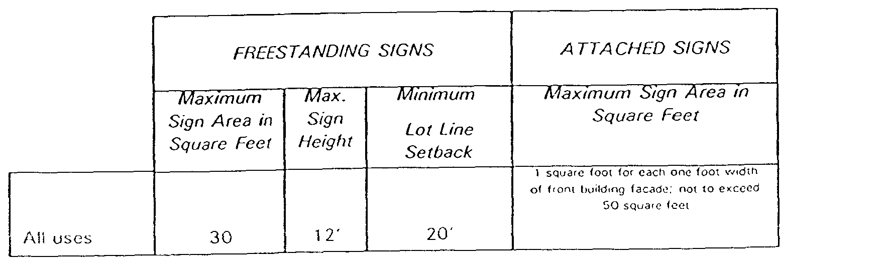
a. Henry-Oliver Avenue Redevelopment Plan: The primary objective of this Plan is "to revitalize the Henry-Oliver District by removing all blighting conditions and influences therefrom, including, but not limited to, those conditions and influences which have led to the stagnation and/or unproductive use of lands, providing for the productive utilization of cleared land areas through the redevelopment of same for their highest and best use and with uses which are compatible with a viable residential neighborhood, which redevelopment may require removing all structures ill a single area in order to provide for an integrated and compatible development This Plan rezones the Henry-Oliver Avenues area from Special Development to C-5C, a Highway Commercial zoning district which permits highway-oriented uses such as office, restaurants (including drive-ins) and bars, retail uses including department stores, discount, outlet and wholesale stores, indoor and outdoor theaters, supermarkets, home-building supply stores (excluding lumber yards), shopping malls and centers, automobile dealerships, hotel and conference centers, motels, park and ride facilities, educational training centers, business and office equipment supply stores, car washes, transportation and communications offices and facilities, public transportation passenger stations and parking facilities, and transmission towers and communications facilities. These uses are permitted on minimum 10,000 square-foot lots with a 25' front yard setback, 20/50' side yards and 20' rear yards. Maximum height permitted is 40', and maximum lot coverage is 50 percent. Parking is permitted in (lie, front yard. The signage standards for this district are similar to those required herein. No billboards are permitted and it is encouraged that "maximum effort should be made to establish a common sign band along all retail buildings fronting on Somerset Street. "(Page 15) The signage standards for all uses are as follows:
b. 1000 Somerset Redevelopment Plan: This Plan covers the area roughly between Camner Avenue and the Railroad right-of-way along Route 27. The 1995 Redevelopment Plan places this area in the HD, Highway Development, zoning district. However, this was amended to the C-5C, Highway Commercial district in December 1996. A portion of this property has been developed as the Aldi Food Store. Off-street parking is permitted in the front yard. The goals of this Plan are as follows:
(1) Increase the utilization of H-D [Highway Development] land by enhancing its attractiveness for retail usage.
(2) Accommodate uses for vacant land that is likely to remain so without inclusion in a redevelopment plan.
(3) Develop new businesses to provide goods and services to the adjacent community.
(4) Relieve problems associated with dilapidated buildings by creating a situation conducive to retail/commercial redevelopment.
(5) Create job opportunities for area residents via commercial development.
(6) To remedy the visual appearance of the land and thus enhance its value and the values of adjacent properties.
(7) Design the development of the parcel to minimize the number of access points on to Route 27.
(8) Maintain existing acceleration and deceleration lanes to and from the site on Route 27 and look to their potential enhancement.
(9) Install all utility lines underground to improve the aesthetic appearance of the area.
C. Edpas Road Redevelopment Plan: The primary objective of this Plan is 'to revitalize the Edpas Road District by removing all blighting conditions and influences therefrom, including, but not limited to those conditions and influences which have led to the stagnation and/or unproductive use of lands, providing for the productive utilization of cleared land areas through the redevelopment of same for their highest and best use and with uses which are compatible with a viable residential neighborhood, which redevelopment may require removing all structures in a single area in order to provide for an integrated and compatible development.
(1) This Plan governs the residential area to the rear of the foregoing two Redevelopment Areas in the City. The Plan places the area in the R-6, Multi-Family zoning district and permits maximum residential densities of 28 units per acre in 3-story structures.
(2) The City's Zoning Map places the majority of the remaining area, not in City Redevelopment Areas, across Route 27 from the Franklin Redevelopment Area in the R6, Multi-Family, zoning district. The R-6 area includes St. Peter's Cemetery and the residential areas between the cemetery and Quentin Avenue, and Van Dyke Avenue and Jennings Court.
(3) The goals and objectives of the foregoing redevelopment plans are compatible with those of the Franklin Township Plan. In terms of design standards for uses, although development standards in the Franklin Redevelopment Area and the City zoning standards in the Renaissance 2000 New Brunswick area are generally compatible, it is recommended that a joint design standard document be adopted by both municipalities to ensure consistent design particularly in (lie areas of signage, the location of offstreet parking, building design and landscaping.
6. Somerset County Master Plan
The 1987 Somerset County Master Plan is structured to be the intermediary planning document between the State Development and Redevelopment Plan and individual municipal master plans. The Redevelopment Plan is consistent with the following goals of the 1987 County Plan:
a. To relate development activities to long-range trends and the essential utilities and services necessary to support future development in an economical and environmentally-sound manner.
b. To focus future development opportunities in and around logical areas of existing development by encouraging a variety of housing types, convenient employment opportunities, and investments in utilities and transit facilities in defined areas. The effort should be to prevent further sprawl development by increasing the capacity and efficiency of existing core areas of development in order to attract new development.
c. To discourage sprawl development patterns, and to that end, discourage the extension of water, sewer and highway systems into areas considered inappropriate for development. Public and quasi-public investments should be directed to upgrading and providing additional capacity to the existing systems by modernizing them, Improving their capacities, [and] replacing deteriorated sections[.]
d. To preserve a safe, healthy and visually pleasing environment by...fostering building and landscape designs that encourage visually pleasing buffers, facades, and spatial relationships[.]
In the 1987 Somerset County Master Plan, the Area is located in a Growth Management area and a Corridor Development area along Route 27. The following policies of the Growth Management area as set forth by the County are consistent with the Plan:
e. Maintain a balance between housing, jobs and support services;
(1) Coordinate planning, zoning and utility plans/extension policies;
(2) Maintain adequate open space/recreation;
(3) Upgrade or expand community facilities, i.e. schools, day care
(4) Promote mixed-use and high quality design standards.
f. The following policies of the Corridor Development area are consistent with the Plan:
(1) Improve highway safety and capacity;
(2) Coordinate planning at all levels in order to implement a unified transportation management program;
(3) Limit large-scale commercial development to corridors/nodes with regional highway access which can be served with transit services and public facilities;
(4) Minimize strip development and cluster in nodes;
(5) Plan for ... low cost capital improvements.
7. State Development and Redevelopment Plan
The SDRP places the Redevelopment Area in Metropolitan Planning Area I (PAI). The proposed Redevelopment Plan is consistent with the planning goals and objectives of the SDRP as a whole, and of PA1 In particular. In terms of and Use, the proposed Plan emphasizes the efficient use of infrastructure and public facilities, Including recreation facilities, and revitalization of existing housing and commercial building ,stock-. Affordable housing opportunities for the elderly and the creation of job opportunities through Commercial development are a priority. Public/private partnerships are already a strong presence in the Area as a part of Renaissance 2000. The proposed Plan makes great efforts to encourage efficient transportation and circulation in the Redevelopment Area, including promotion of pedestrian safety and access to mass transit. This Redevelopment Plan is the product of joint planning in two municipalities within two different counties, and has been funded by a Somerset County Economic Development Program grant.
M. ADMINISTRATIVE AND PROCEDURAL REQUIREMENTS
1. Amending The Redevelopment Plan
Upon compliance with the requirements of applicable law, the Township Council of Franklin Township may amend, revise or modify this Redevelopment Plan, as circumstances may make such changes appropriate.
2. Duration Of Redevelopment Plan
The Redevelopment Plan, as amended, shall be in full force and effect for a period of thirty (30) years from the date of approval of this Plan by the Township Council.
3. Conveyance Of Land
The Township Council or Redevelopment Agency may sell, lease, or otherwise convey to a redeveloper for redevelopment, subject to the restrictions, controls and requirements of this Redevelopment Plan, all or any portion of the land within the Redevelopment Area which becomes available to disposal by the municipality as a result of public action under this Plan. The Township reserves the right to formulate an agreement under any of the above-referenced arrangements and to enforce resale covenants.
4. Criteria And Procedures For Redeveloper(s) Selection And Implementation Of Redevelopment Plan
The following restrictions and controls on redevelopment are hereby imposed in connection with the selection of a redeveloper(s) and shall apply notwithstanding the provisions of any zoning or building ordinance or other regulations now or hereafter in force. Items (2) through (5) and (8) hereunder shall be implemented by appropriate covenants or other provisions in redeveloper(s) agreements and/or disposition instruments.
a. Applicants for designation as redeveloper must submit the following materials to the designated entity for review and approval:
b. Documentation evidencing financial responsibility and capability with respect to the proposed development;
c. Estimated offering price and deposit for acquisition of any land(s) to be acquired from the municipality for development;
d. Estimated total development cost;
e. Fiscal impact analysis addressing the effect of the proposed project on municipal services and tax base;
f. Estimated time schedule for start and completion of development; and
g. Conceptual plans and elevations sufficient in scope to demonstrate the design, architectural concepts, parking, traffic circulation, landscaping, active and/or passive recreation space, and sign proposals for all uses and, in addition, (a) bedroom distribution and size of dwelling units for any residential development, and (b) loading requirements for any proposed nonresidential use.
h. The redeveloper(s) will be obligated to carry out the specified improvements in accordance with the Redevelopment Plan.
1. The redeveloper(s), its successors or assigns shall devote land within the Redevelopment Area to the uses specified in this Redevelopment Plan.
j. The redeveloper(s) shall begin and complete the development of said land for the use(s) required in this Redevelopment Plan within a period of time which the Township Council or Redevelopment Agency fixes as reasonable.
k. Until the completion of the improvements, the redeveloper(s) will not be permitted to sell, lease, or otherwise transfer or dispose of property within the Redevelopment Area without prior written consent of the designated entity.
l. Upon completion of the required improvements, the conditions determined to exist at the time the Redevelopment Area was determined to be in need of redevelopment shall be deemed to no longer exist, and the land and improvements thereon shall no longer be subject to eminent domain as a result of those determinations.
m. No covenant, agreement, lease, conveyance or other instrument shall be effected or executed by the redeveloper(s), the Township Council or Redevelopment Agency, or the successors, lessees, or assigns of either of them, by which land in the Redevelopment Area is restricted as to sale, lease, or occupancy upon the basis of race, color, creed, religion, ancestry, national origin, sex or marital status.
n. Neither the redeveloper(s) nor the Township Council or Redevelopment Agency, nor the successors, lessees, or assigns or either of them shall discriminate upon the basis of race, creed, religion, ancestry, national origin, sex or marital status in the sale, lease or rental or M the use and occupancy of land or improvements erected or to be erected thereon, or any part thereof, in the Redevelopment Area.
Block 123 is rezoned from Residential Infill to Gateway Commercial.
**Webmasters Note: The section previous sentence has been added as per Ordinance No. 3465.

