
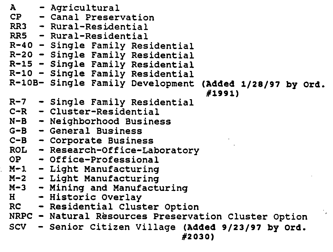
A. ESTABLISHMENT OF ZONING DISTRICTS
For the purpose of this Ordinance, the Township of Franklin is divided into the following zoning districts:
Note - the zoning requirements for Agricultural Option shall remain in effect for the Wildflower Ridge development
**Webmasters Note: The previous subsection has been amended as per Ordinance No. 3416.
B. ZONING MAP
The location and boundaries of districts are hereby established as shown on the zoning map of the Township, dated June 1984 which is hereby made a part of this ordinance and incorporated herein by reference.
(1) OFFICIAL ZONING MAP
The aforesaid zones are established by the designations, locations and boundaries set forth and indicated on the Official Zoning Boundary Maps to be located in the Off ice of the Township Engineer and to be maintained by him. A Zone Location Map indicating the designations and locations shall be attached to all copies of this ordinance for informational purposes only.
(2) AMENDMENTS
If, in accordance with the provisions of this chapter and the revised statutes of the State of New Jersey, changes are made in the district boundaries or other matters portrayed in the map by the Township Council, such changes shall be made promptly by the Engineer after the amendment had taken effect as provided by law. For each change in the map, note shall be made thereon, in the revision box, of the date of revision, zones affected by the revision and a brief identifying description of the revision. These changes are to be endorsed upon the map on the effective date of the amendment.
(a) Section 112-6B, Zoning Map, is hereby amended to change Block 262, Lots 3 through 10 from the O-P Designation to the R-7 Designation and, further Lots 1, 2, 11 and 12 are designated' O-P. (Amended S/13/86 by Ordinance #1276).
(b) Section 112-6B, Zoning Map, is hereby amended to change the designation of certain property as delineated on the attached map which is incorporated herein and made a part hereof from R-40 to M-2. (Amended 12/9/86 by ordinance #1311).
(c) Section 112-6C, Official Zoning map, is amended to change lands within Block 468.02, 468.08 and a portion of Block 468.01 from R-15 to M-2, all as more particularly described and designated in the attached Map, which is incorporated herein by reference, dated July 2, 1985 prepared by Oross Associates and entitled Amendment Franklin Township Zoning Map. (Amended 9/12/85 by Ordinance #1244).
(d) Section 112-6C, Official Zoning Map, is amended to change the designation of certain property as delineated on the attached map which is incorporated herein and made a part hereof from RR to CP-Canal Preservation Zone. (Amended 4/25/89 by Ordinance #1481).
(e) Section 112-6C, Official Zoning Map, is amended to change the designation of certain property as delineated on the attached map which is incorporated herein and made a part hereof from RR to RR3 and RR5. (Amended 7-11-89 by ordinance #1500).
(f) Section 112-6C, Official Zoning Map, is amended to change the designation of certain property as delineated on the attached map which is incorporated herein and made a part hereof known as Lot 15 in Block 18 from RR to R-40. (Amended 7/11/89 by ordinance #1500).
(g) Section 112-6C, Official Zoning Map, is amended to change the designation of certain property as delineated on the attached map which is incorporated herein and made a part hereof from A to CP-Canal Preservation Zone. (Amended 8/8/89 by Ordinance 01507).
(h) Section 112-6C, official Zoning Map, is amended to change the designation of certain property an delineated on the attached map which is incorporated herein and made a part hereof from RR to RR3 Zone (Amended 11/14/89 by ordinance #1526).
(i) Section 112-6C, Official Zoning Map, is amended to change the designation of certain property as delineated on the attached map which is incorporated herein and made a part hereof from Canal Preservation to R-40 Zone. (Amended 11/14/89 by ordinance #1527).
(j) Section 112-6C, official Zoning Map, is amended to change the designation of certain property as delineated on the attached map which is incorporated herein and made a part hereof from RR-3 to C-R. (Amended 6/11/91 by ordinance 11642; 1/14/92 by Ordinance #1689).
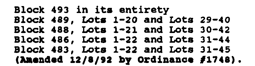
(k) Chapter 112, Development, Article II, Zoning, Section 112-6B (Zoning map) and 112-6C (Official Zoning Map) is amended to change the designation of the following property from M-2 to R-20 Zone: Block 86.03, Lot 11 (Amended 12/8/92 by ordinance 01747).
(l) Chapter 112, Development, Article II, Zoning, Section 112-6B (Zoning Map) and 112-6C (official Zoning Map) is amended to change the designation of the following properties from CB and ME to R-10 Zones:
(m) Chapter 112, Development is amended to change the designation of certain property as delineated on the attached map designated as Exhibit A which is incorporated herein and made a part hereof from CR to R-10A: (Goldstar/Crossland tract) (Amended 10/24/95 by ordinance #1921).
(n) Official Zoning Map, is amended to change the designation of certain property known as Lot 11 in Block 86.03 on the Tax Map of the Township of Franklin from R-20 to M-2. (Amended 6/25/96 by ordinance #1963)
(o) Official Zoning Map, is amended to change the designation of certain property as delineated on the attached Map designated Exhibit A which is incorporated herein and made a part hereof from CR to R-10B and RR3. (Amended 1/28/97 by Ordinance #1991)
(p) There is hereby permitted and authorized the establishment of a planned Senior Citizen District for Block 513 and as shown on the attached Exhibit A and same shall be an amendment to the Official Zoning Map of the Township of Franklin, County of Somerset, State of New Jersey and as herein defined, in accordance with the provisions and requirements of this section. The provisions of this section shall only apply to the Senior Citizen Village District. (Added 9/23/97 by Ordinance #2030)
(q) Official Zoning Map is amended to change the designation of certain property as delineated on the attached Map designated Exhibit A which is incorporated herein and made a part hereof from ROL to M-1, A & RR3. (Added 10/14/97 by Ordinance #2038)
(r) Official Zoning Map is amended to change the designation of certain property known as Block 20.02, Lot 8 as delineated on the attached Map designated Exhibit A which is incorporated herein and made a part hereof from A-Agricultural to RR3-rural Residential Zone. (Added 6/10/99 by Ordinance #3051)
(s) Official Zoning Map is amended to change the designation of certain property known as Block 528.06, Lots 5.05, 5.06. 5.07, 6, 7, 8, 20-25; Block 528.04, Lots 19.03, 19.07, 19.10, 139-143; Block 528.03, Lot 169.03 and Block 517.06, Lots 9-14 on the tax map of the Township of Franklin from CB to M-1. (Added 8/8/00 by Ordinance #3148)
(t) Official Zoning Map is amended as it refers to Block 514 Lots 56 and 35 to change the zone designation as follows: Lot 56 to ROL; Lot 35 to M-1. (Added 9/25/01 by Ordinance #3238)
(u) Official Map is amended to change the designation of certain property known as Block 259/Lot 74 on the tax map of the Township of Franklin from GB to CP. (Added 11/13101 by Ordinance No, 3251)
**Webmasters Note: The previous subsections, (o) through (u), have been amended as per the 2001 Supplement.
(w) Official Zoning Map is amended to change the designation of certain property know as:
Block 1.01/Lots 4, 5, 6, 8, 9.01,10,11.01
Block 1.02/Lot 9.02, 11.02 12
On the tax map of the Township of Franklin from zone designation ROL to CP
Block 468.08 Lot 1 [Currently Zoned M-2]
On the tax map of the Township of Franklin from zone designation M-2 to OP
There shall be permitted and authorized a Senior Citizen District Overlay for Block 468.08/Lot 1
Block 74.01 Lots 7, 8.01, 9, 10, 11 and 14 on the tax map of the Township of Franklin from zone designation R-40 to A as shown on the attached Exhibit A, effective December 31, 2005.
**Webmasters Note: The previous subsection has been amended as per Ordinance No. 3555A.
(x) Official Zoning Map is amended to change the designation of certain property know as:
Block 1.02/Lot 13
On the tax map of the Township of Franklin from zone designation R10H to CP.
(x) Official Zoning Map is amended to change the designation of a portion of property in Parcel 10B on the tax map of the Township of Franklin as shown on the attached map from A to S-C-V.
**Webmasters Note: The previous subsection has been added as per Ordinance No. 3437. According to the original document there are duplicate subsections lettered (x).
(y) Official Zoning Map is amended to change the designation of certain property know as:
Block 5.02/Lot164, 165 and 167 [currently designated R-20]
On the tax map of the Township of Franklin from zone designation R20 to A.
(z) Official Zoning Map is amended to change the designation of certain property know as:
Block 5.02/Lots 112.01,112.02,113.01,113.02,114,115,116.01 117.02,119.03, 168,169,170,171
Block 5.02/Lots 123, 131, 128, 164 and 165 [currently designated ROL]
**Webmasters Note: The previous subsections, (w) through (z), have been added as per Ordinance No. 3379.
(hh) Official Zoning Map is amended to change the designation of certain property known as:
Block 58, Lots 9.01, 10.04 and 10.05 from zone designation "R-40 Residential, Single Family Minimum Lot Area of 40,000 Square Feet" to "A-Agricultural" and as shown on the attached Exhibit A.
**Webmasters Note: The previous subsection has been added as per Ordinance No. 3528. The lettering of the previous subsection is consistent with the original document.

