
If the Total Adjusted Disturbed Area (TADA) is in excess of the Maximum Allowed Disturbance (MAD, Table Two) allowed by this Article, the applicant must either increase the size of the individual lot or investigate the flexible design option or alternative lot grading concepts, including the use of retaining walls, innovative building types which related to slope conditions, or the relocation of the proposed use within the site to avoid disturbance of steeply sloping lands No subdivision or site plan may be approved unless the applicant can demonstrate compliance with this Article�
(6) Lot area adjustment.�
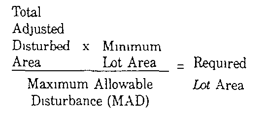
(a) If a larger area of total disturbance than that which is allowed in the schedule is calculated, lot size must be increased to compensate for the additional grading Lot sizes will be calculated as following The adjusted disturbed area times the minimum lot size for that zone, divided by the minimum allowable disturbance for that particular lot size will generate the new lot size�
(b) In no case shall the minimum lot size be less than that required for the zone district within which the site is located�
(1) No soil shall be excavated, removed or deposited within a sloped area except as a result of and in accordance with a we grading plan approved by the Township Engineer�
(2) Any proposed disturbance of sod shall be for purposes consistent with the intent of this Article and shall be executed in a manner that will not cause excessive erosion or other unstable conditions�
(3) Provision shall be made for the proper disposition of surface water runoff so that it will not create unstable conditions, appropriate storm drainage facilities shall be constructed as deemed necessary, and adequate protective measures shall be provided for downstream properties�
(4) Provision shall be made to ensure any structures or protective measures that proposed slopes may require for the protection of the public safety, including but not limited to retaining walls, headwalls and fences�
�
(5) Any proposed building or structure or attendant protective measures will not impede the flow of surface waters through any watercourse or cause an increase in flood heights or velocities�
(6) Detailed site grading plans shall show the following information�
(a) The detailed site grading plan shall be drawn and certified by a licensed professional engineer, landscape architect or architect at a scale of not less than one (1) inch equals fifty (50) feet for sue plans or subdivisions up to ten (10) units and one (1) inch equals one hundred (100) feet for size plans with over ten (10) units�
(b) The Tax Map sheet, block and lot number, date, graphic scale, North arrow and the names and addresses of the owner or owners of the tract, the applicant (if other than the owner) and of the engineer who prepared the sue plan�
(c) All lot line dimensions�
(e) Location of all proposed buildings, dimensions thereof and first floor elevation�
(f) Location of all buildings on adjoining lots�
(g) Existing and proposed contours at a contour interval of two (2) feet or less�
(h) The proposed elevations of the levels of any land at the corner of the foundation of any structure or structures and the levels of land above and below retaining walls as well as top or wall elevations�
(i) The layout of existing and proposed public streets and public utilities�
(j) The location of any existing or approved potable water or sanitary sewage disposal facilities on or within one hundred (100) feet of the lot�
(k) The location of proposed vehicular facilities including roads, drives or parking areas�
(l) The location of all existing landscaping, including trees, shrubs and ground covers with type and size of trees or shrubs The location of trees over eight (8) inches in diameter must be specifically indicated�
(m) The disposition and extent of topsoil to be removed or backfilled�
(n) The disposition and extent of all other soil to be removed or backfilled�
(o) The plans and specifications for any proposed retaining walls, fences or other protective structures�
(p) A slope map showing existing slope areas per the definition of 'limit of grading" in § 134-450 D and all calculations necessary to determine compliance with this section�
D. Detention facilities Detention facilities must be provided as per municipal and state regulations and approved by Township Engineer�
A. All specimen trees ever eighteen (18) inches in caliper within the area of disturbance shall be indicated on the required site plan Every effort shall be made to provide a layout to avoid any disturbance within the specimen trees dripline An estimate of all trees over eight (8) inches in caliper shall be submitted If, in the opinion of the approving authority, the estimate is not a reasonable projection of actual field conditions, a precise count shall be required The elimination of any deciduous tree of this caliper shall be replaced in equal number by a tree of at least three-inch caliper, the species of which is either identical to the tree being removed or is otherwise referred to in the United States Soils Conservation�
Service as compatible with the soil type, or a coniferous tree of at least eight (8) feet in height at the time of planting Coniferous trees shall be replaced by a similar coniferous tree at least eight (8) feet in height at the time of planting�
B. In the event that a lot is fully wooded and the development does not exceed the maximum allowable disturbance, tree replacement and the number of trees required shall be determined by the municipal agency by the ability of the land to accommodate said trees. If sufficient space is not available on the lot on which the development is proposed, the municipal agency may require the applicant to plant the replacement trees on other lands owned by the applicant within the Township of Wayne, on municipal parklands, within public street rights-of-way or any combination thereof. In addition to the aforementioned locations, the municipal agency may permit the applicant to plant replacement trees on lands owned by lake associations, but not on lands owned by association members; lands of the Board of Education of the Township of Wayne; lands owned by the County of Passaic; lands of any charitable and/or non-profit organization, or any combination thereof. �
**Webmasters Note: The previous subsection has been amended as per Ordinance No. 74- 2003.�
A. The rules, regulations and standards contained in this Article shall be considered the minimum requirements for the protection of the public health, safety and welfare of the citizens of the township The municipal agency, when acting upon applications properly before it, shall have the power to grant such waiver from the requirements of this Article In the case of a waiver request connected with a building permit(s) not part of a subdivision or site plan application, the Planning Board shall hear and determine whether such relief is appropriate�
B. Any action taken by the municipal agency under the terms of this Article shall give primary consideration to the abovementioned matters and to the welfare of the entire community However, if the developer or his agent can clearly demonstrate that, because of peculiar conditions pertaining to his land, the literal enforcement of one (1) or more of these regulations is impracticable or will exact undue hardship, the municipal agency may permit such variations or modifications as may be reasonable and within the general purpose and intent of the rules, regulations and standards established by this Article If such exception is granted, it shall be done by resolution of the municipal agency, which resolution sets forth the reasons for the exception in the particular case and demonstrates that the exception will not have an adverse effect on surrounding properties, the neighborhood or the township in general�

