[Added 9-7-1988 by Ord No 57-1988, amended 10-3-1990 by Ord No 69-19901]�
A. Purpose The purpose of this Article is to protect the health and safety of the community insofar as it relates to the protection and the preservation of those natural features, including geology, hydrology, soils and vegetation considered as development constraints It is of particular concern to maintaining ecological balance, a healthful environmental quality and protection of historic resources This Article shall control the number and size of building lots and maximum development permitted upon lots in all zones in the township The regulation is applicable to any subdivision, site plan and building permit, including additions, pools, decks, paving and grading in excess of two hundred fifty (250) square feet�
B. Environmental factors The environmental factors that must be considered, if and where present, are as follows:�
(1) Floodplains�
(2) Slopes�
(3) Flood hazard areas, open water, streams, ponds and lakes�
(4) Wetlands and wetland transition areas�
(5) Areas of zero (0) to one (1) foot seasonal high-water table�
(6) Historic sites�
(7) Sod disturbance�
(8) Trees and vegetation�
(9) Depth to bedrock�
C. Applicability�
(1) Size of area of construction�
(a) This regulation is applicable to any subdivision or sue plan application, grading permit or building permit, including additions, pools, decks, paving and grading in excess of two hundred fifty (250) square feet. A site grading plan will be required as part of any such application at the submission for subdivision, and at the submission for a building permit.�
(b) For projects with an area of construction between two hundred fifty (250) and eight hundred (800) square feet, the site grading plan may be prepared by the applicant If construction is proposed in areas with none of the listed environmental factors, the Township Zoning Officer, Planner and Engineer shall inspect and accept said determination and thereafter process the appropriate application�
(c) For projects with an area of construction in excess of eight hundred (800) square feet, or where it has been determined that environmental factors exist, full compliance with this Article shall be required�
(d) In determining the applicability of Subsection C(1)(a),(b) and (c) above, if an existing developed lot contains existing impervious surfaces, the square footage of these existing surfaces may be excluded from the proposed area of construction calculation�
(2) In the case of applications for major subdivisions submitted after October 4, 1988, in lieu of submitting detailed grading plans, the applicant shall submit conceptual lot grading plans for the purposes of preliminary subdivision approval.�
(3) Any recorded lot or approved preliminary or final subdivision plat or approved site plan or buildings or structures existing on the effective date hereof may be continued even though they may not conform to the provisions of this Article However, nothing herein contained shall be construed to permit a nonconforming lot to be made more nonconforming At the time of application for a building permit, a site grading plan conforming to Ï 134-456 shall be submitted to the Township Engineer for review and approval�
(4) Upon compliance with the provisions of this Article, the township shall issue one (1) of the following based upon the application�
(a) Grading permit�
(b) Building permit�
(c) Letter of compliance (for site plan or subdivision applications)�
(5) Reseeding or sodding of lawns and installation of landscaping on preexisting lawn or landscaped areas are exempt from the provisions of this Article�
(6) Previously disturbed pervious areas which lime been restored by landscaping or otherwise stabilized as found acceptable by the township for a period of at least five (5) years shall be exempt from the provisions of this Article�
D. Definitions for the purpose of this section Certain terms are defined and shall be construed as follows�
CUT OR EXCAVATION - The result of any act by which soil or rock is cut into, excavated, dug, quarried, uncovered, removed, displaced or relocated�
DISTURBANCE - Any activity involving the clearing, excavating, storing, filling or transporting of soil or any other activity which causes soil to be exposed to the danger of erosion, The area of lot 'disturbance' shall include all portions of a lot which will be disturbed by grading activity during construction. In addition, this area shall also include all proposed impervious cover, such as buildings, driveways and patios, even if built on existing grade, and shall also include the sewage disposal beds if any are existing or proposed Beyond the impervious cover and sewage disposal beds, the area of lot grading shall be synonymous with the limit of grading�
FILL - A man-made deposit of soil, rock or other materials�
�
GRADING - Any stripping, cutting, filling or stockpiling or any combination thereof, including the land in its cut or filled condition�
LIMIT OF GRADING - The boundary line for tried between those areas of a site, which are to be graded and the existing natural topography of the property The "limit of grading" shall be synonymous with a no-cut/no-fill line�
SLOPES - Degree of deviation of a surface from the horizontal, usually expressed in percent or (rise - run x 100)�
STREAM - Any blue line body of water shown on United States Geological Survey maps, and any tributary with a drainage basin of ten (10) acres or greater�
�
E. Classification of topographical features Land for any individual development parcel will be classified into the following slope categories or combination thereof as determined from topographic maps at two-foot contours�
(1) Areas with slopes from zero percent (0%) to seven and nine tenths percent (7.9%) are ideal for development, septic fields are limited to land with slopes of less than eleven percent (11%)�
(2) Areas with slopes eight percent (8%) to fourteen and nine tenths percent (14.9%) are suitable for residential or small commercial development.�
(3) Areas with slopes from fifteen percent (15%) to nineteen and nine tenths percent (19.9%) can be developed as low density residential�
(4) Areas with slopes from twenty percent (20%) to twenty-three and nine tenths percent (23.9%) can be developed with very low-density residential�
(5) Areas with slopes of twenty-four percent (24%) and over are severe and should be avoided for any type of development.�
A. The number of building lots on any site (i.e., land holding capacity) shall be calculated by determining the acreage of each environmental factor, public rights of way and/or dedicated lands within the boundaries of the site and applying a development factor to it. Multiplication of the various areas by a development factor provides the land area to which the density for each zone can be applied. In those cases where land areas contain two or more overlapping environmental factors, the most restrictive shall apply. For those development applications that do not involve subdivision of property into individual building lots but rather involve a site plan for attached, multifamily or clustered housing, the permitted residential density for the development shall be determined and predicated upon the calculation of available buildable land area according to the factors set forth under Table One contained in Section 134-451 D. The same procedures as outlined in Section 134-451 B through F shall therefore, apply to all residential development within the township regardless of zone�
**Webmasters Note: The previous subsection (A) has been amended as per Ordinance No. 81- 2006�
B. A site base plan must be presented by the applicant showing the following�
(1) Boundaries (prepared by a licensed land surveyor)�
�
(2) Topography at two-foot contours�
(3) Vegetation, including the specific location of trees over eighteen (18) inches in caliper�
(4) Flood hazard areas, open water, streams, ponds and lakes�
(5) Wetlands, wetland transition area�
(6) Soil types�
(7) Areas of zero (0) to one (1) foot seasonal high water�
(8) One-hundred-year floodplains�
(9) Depth to bedrock less than three (3) feet�
C. The first step in this process is to determine the acreage in each of the following categories�
(1) Existing public rights-of-way and/or other dedicated lands�
(2) One-hundred-year flood hazard zone Ps determined by Federal Emergency Management Agency flood insurance maps or through competent field verification The acreage in this category is best suited for open space and as such cannot be used to calculate the total number of building lots�
(3) Flood hazard areas, open water, streams, ponds and lakes If these water areas overlap the one-hundred-year flood zone, only the areas outside the flood zone need be calculated This acreage must be maintained in open space.�
(4) Wetlands, as defined by the United States Army Corps of Engineers or the New Jersey Department of Environmental Protection, with competent field verification, and, in addition, the area of lands assigned to wetland transition areas, where appropriate If this area overlaps one (1) of the above categories, only the area outside the one-hundred-year flood zone and open water areas need be calculated�
(5) Areas of zero (0) to one (1) toot depth to seasonal high water as determined from United States Soil Conservation Service Maps or from competent field verification If this land area overlaps the one-hundred-year flood areas, open water or wetlands, only the difference between these areas and the area of zero (0) to one (1) foot seasonal high water can be used to determine and calculate holding capacity�
(6) Areas with slope greater than twenty-four percent (24%)�
(7) Areas with slope ranging from twenty percent (20%) to twenty-four percent (24%)�
�
(8) Areas with depth to bedrock of three (3) feet or less�
(9) Historic sites If buildings or groups of buildings on a site are appropriate for historic preservation, and if historic buildings are preserved according to the Secretary of Interior's guidelines, the land area devoted to this preservation is a bonus in determining land holding capacity on the rest of the sue However, the land area eligible for this bonus shall not exceed a radius of one hundred (100) feet around any established historic structure or to the property boundary lines, whichever is less, and any historic structure must be included in the total number of units allowed on the site�
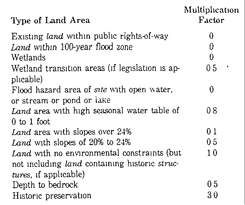
D. The second step in the process is to determine the developable land capacity by multiplying the land area with the various environmental constraints by the appropriate factor as indicated in Table One The product of each of these individual calculations are added together to determine the base developable land area.�
Table One - Multiplication Factors for Land Areas With Environmental Constraints and Historic Preservation Potential�
E. The third step is to multiply the developable land area by the base density applicable to the site's zoning district.�
F. The above calculations determine the number of building lots�
A.Findings It is hereby found that the removal of vegetative cover, sad disturbance and construction of buildings and structures in areas of steep slopes within the township increase surface water runoff, soil erosion and sedimetentation, siltation, when directly adjacent to stream corridors, with resultant pollution of streams as well as the potential danger of flooding and chemical contamination of water, thereby increasing the potential for endangering public and private property and life It is also found that this condition is aggravated by sort disturbance, construction and development on these slopes, which creates an additional hazard to the lives and property of those Dwelling on and below them, and that the most appropriate method of alleviating such conditions is through the regulation of construction and development leading to such vegetation and soil disturbances It is, therefore, determined that the special and paramount public interest in these slopes justifies the regulation of property located thereon as provided in this Article, which is the exercise of the police power of the township for protection of per-sons and the property of its inhabitants and for the preservation of the public health, safety and general welfare Every effort shall be made to minimize construction upon areas with environmental constraints as defined herein�
B. Area requirements for individual tots�
�
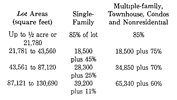
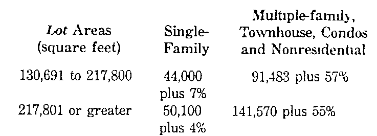
(1) Maximum allowable disturbance factor (MAD) for individual lots within a subdivision or site plan No subdivision, site plan or building permit for any zone shall be approved if the total area of lot disturbance exceeds the following standards�
Table Two - Maximum Allowable Disturbance (to be calculated in square feet)�