
[Amended 12-23-2002 by Ord. No. 50-02; 1-22-2008 by Ord. No. 04-08; 8-12-2008 by Ord. No. 31-08; 11-9-2010 by Ord. No. 30-10; 11-9-2010 by Ord. No. 32-10; 11-9-2010 by Ord. No. 33-10; 11-9-2010 by Ord. No. 34-10; 11-9-2010 by Ord. No. 35-10; 7-27-2011 by Ord. No. 24-11] For the purpose of this chapter, the non-Pinelands Area portion of the Township of Jackson shall be divided into the following zoning districts:�
R-3 Residential Zone�
R-2 Residential Zone�
R-5 Residential Zone�
R-1 Residential Zone�
R-20 Residential Zone�
R-15 Residential Zone�
R-9 Residential Zone�
R-30 Residential Zone�
MF Multifamily Zone�
MF-AH-6 Multifamily Affordable Housing-6 Zone�
MHP Mobile Home Park Zone�
PRC Planned Retirement Community Zone�
PMURD Planned Mixed Unit Residential Development Zone�
LC Limited Commercial Zone�
NC Neighborhood Commercial Zone�
HC Highway Commercial Zone�
CR-1 Commercial Recreation Zone 1�
CR-2 Commercial Recreation Zone 2�
ROS Recreation - Open Space Zone�
AR Agricultural Retention Zone�
LM Commercial Office/Light Industrial Zone�
I.Industrial Zone�
[Amended 2-8-2011 by Ord. No. 02-11] The boundaries of all zoning districts set forth in this chapter are shown on a map entitled "Zoning Map, Township of Jackson, Ocean County, New Jersey," prepared by Remington, Vernick & Vena Engineers, Township Planner, dated December 20, 2010, which map is hereby made a part of this chapter. A copy of the Zoning Map is on file in the Office of the Township Clerk.�
A. The boundaries of zoning districts shall be shown on the Zoning Map. Where uncertainty exists with respect to the zone boundaries of any of the zoning districts, as listed above in § 244-42 of this chapter and as shown on the Zoning Map, the following rules shall apply:�
(1) Along streets and highways. Where district boundaries are indicated as approximately following the center lines of streets or highways, street lines or highway right-of-way lines, such center lines shall be construed to be such boundaries.�
(2) Along lot lines. Where district boundaries are so indicated that they approximately follow the lot lines, such lot lines shall be construed to be said boundaries.�
(3) District lines parallel to streets and highways. Where district boundaries are so indicated that they are approximately parallel to the center lines or street lines of streets or the center lines or right-of-way lines of highways, such district boundaries shall be construed as being parallel thereto and at such distances therefrom as indicated on the Zoning Map. If no distance is given, such dimension shall be determined by the use of the scale shown on the Zoning Map.�
(4) Along streams, lakes or other bodies of water. Where the boundary of a district follows a stream, lake or other body of water, the boundary shall be deemed to be at the limit of the jurisdiction of the Township unless otherwise indicated. Where a district boundary is shown as following a stream, the boundary shall be the center line of the main channel of such stream, and the boundary shall be deemed to be changed automatically if the main channel of the stream should change or be changed by natural or artificial means, if such new center line is no farther from the old center line than 20 feet at any point.�
(5) Vacating of streets. Whenever any street or public right-of-way is vacated by official action, the zoning districts adjoining the side of such public way shall be automatically extended to include the right-of-way thus vacated, which shall be subject to all regulations of the extended district or districts. Where the vacated right-of-way is bounded on either side by more than one district, the former center line of the right-of-way shall determine the extension of each district.�
(6) Map dimensions. In the absence of specific distances being indicated on the Zoning Map or as specified in any of the above, the distance shall be determined by using the map scale.�
B. Where a zoning district boundary line divides a lot other than by following a stream, street or railroad, any use permitted in either district may be extended not more than 20 feet into the adjacent district. A use permitted in the zoning district so extended shall thereafter be a permitted use in the extended area. A zoning district line, however, shall be altered only once by utilizing this subsection of this chapter, after which the lot use shall be governed by the regulations of the zoning district in which it is located after the zoning district boundary line adjustment.�
C. The exact location of any disputed zoning district boundary line shall be determined by the administrative officer. This decision may be appealed to the Zoning Board of Adjustment.�
[Added 11-9-2010 by Ord. No. 28-10]�
A. Intent and purpose. The governing body of the Township of Jackson, recognizing the extensive riparian lands, streams, lakes, surface water bodies, wetlands, and woodlands which contain vegetation and habitats, including habitats for many threatened and endangered species, and which are found to exist on significant numbers of acreage of the remaining undeveloped lands within the Township of Jackson; and recognizing and anticipating the significant impacts on these lands resulting from development, which impacts are mitigated by comprehensive regulations as described and implemented by the New Jersey Department of Environmental Protection (N.J.A.C. 7:1 through 7:62), the Pinelands Commission and the Pinelands Comprehensive Management Plan (N.J.A.C. 7:50), and the New Jersey State Development and Redevelopment Plan (N.J.A.C. 17:32); and, in furtherance of the Township of Jackson's commitment to preserve, conserve, and protect those environmentally critical lands which support and affect the watersheds, aquifers, and environmental integrity of lands which are contiguous and extend outside of the Township of Jackson; and in order to provide sound use of the land and appropriate land densities as provided for in N.J.S.A. 40:55D-2; identifies by the Conservation Zone Overlay those lands which are therefore affected and are therefore subject to the following:�
B. Applicability.�
(1) All properties where a portion or all of the lot is included within the Conservation Zone Overlay boundaries, as determined and shown as shaded areas overlaid on the Jackson Township Zoning Map, and further clarified on the Conservation Plan Map.�
(2) Modifications to this zone will be adjusted only as a result of a valid NJDEP letter of interpretation or permit delineating wetlands, streams, buffers, transition areas and/or identifying critical habitats or the lack thereof.�
C. Zone regulations.�
(1) All properties which fall within the Conservation Zone Overlay shall be regulated by the underlying zone or district within which they are found, except that the following additional requirements shall apply.�
(a) All applications for major site plan or major subdivision approvals shall be required to submit a valid NJDEP letter of interpretation and/or permit which identifies all freshwater wetlands and wetlands buffers/transition areas on the property or properties included in the application before the application can be deemed complete.�
(b) All wetlands, wetlands buffers, transition areas, and riparian buffers must be properly identified and delineated on all submitted plans for major site plan or major subdivision approvals before the application can be deemed complete.�
(c) All wetlands, as identified and verified, pursuant to the LOI (letter of interpretation) required before any application can be deemed complete, as stated in Subsection C(1)(a) above, shall be excluded from the gross acreage for purposes of calculating gross residential density and for calculating maximum lot coverage (building and impervious) for nonresidential developments, except for commercial and industrial properties for the term of economic priority established in Subsection D below.�
[Amended 2-8-2011 by Ord. No. 09-11]�
(d) All required setbacks shall be taken from the wetlands limits pursuant to the LOI (letter of interpretation) required before any application can be deemed complete as stated in Subsection C(1)(a) above, and not the property line as otherwise allowed, except for commercial and industrial properties for the term of economic priority established in Subsection D below. [Amended 2-8-2011 by Ord. No. 09-11]�
(2) Exceptions. Density in the PRC Planned Retirement Community and the PMURD Planned Mixed Unit Residential Development Zones, where a net density maximum has been determined anticipating the exclusion of wetlands and buffers, and as set forth and defined in § 244-6, shall remain unchanged.�
D. The term of economic priority is a period of five years from January 1, 2011, through December 31, 2015, or such term as otherwise extended or shortened by the governing body, in which commercial and industrial developments shall be exempt as described above. [Added 2-8-2011 by Ord. No. 09-11]�
[Amended 8-13-2001 by Ord. No. 36-01]�
A. Permitted principal uses of buildings and structures are as follows:�
(1) Community residences for the developmentally disabled. [Amended 3-10-2003 by Ord. No. 4-03]�
(2) Community shelters for victims of domestic violence. [Amended 3-10-2003 by Ord. No. 4-03]�
(3) Detached single-family dwelling units.�
(4) All farm and agriculture activities, horses, livestock and poultry raising.�
(5) Municipal parks, playgrounds and other such municipal buildings and uses as are deemed appropriate and necessary by the Township Committee.�
(6) Federal, state, county and other public buildings and grounds, including public schools, parks, playgrounds or other public recreational uses or areas.�
(7) Private or parochial schools not operated for profit; except, however, that public and private colleges or universities shall not be permitted.�
(8) Essential services.�
B. Permitted accessory uses of buildings and structures are as follows:�
(1) Dog pens, provided that they are located behind the rear building line and not in the required side or rear yard setback for the respective zone.�
(2) Farm buildings for the storage of farm animals, farm products or farm equipment or for the processing of farm products, and which are located on the same premises as the principal use or building.�
(3) Farm markets for the sale of produce and farm products grown or raised on the premises.�
(4) Fences and walls, subject to the provisions of § 244-190.�
(5) Nurseries and greenhouses.�
(6) Off-street parking and private garages.�
(7) Private residential swimming pools, subject to the provisions of § 244-216.�
(8) Satellite dish antennas, subject to the provisions of § 244-165.�
(9) Sheds (garden, storage or tool).�
(10) Signs, subject to the provisions of § 244-207.�
(11) Other customary accessory uses, buildings and structures, which are clearly incidental to the principal use and building.�
(12) Family day-care home.�
�
C. Conditional uses, subject to the provisions of Article VIII of this chapter, are as follows:�
(1) Cemeteries and mausoleums (§ 244-113).�
(2) Child-care centers, nursery schools and day-care centers (§ 244-114).�
(3) Churches and place of worship (§ 244-115).�
(4) Farmers' markets (§ 244-119).�
(5) Health care facilities (§ 244-120).�
(6) Home occupations (§ 244-121).�
(7) Home professional offices (§ 244-122).�
(8) Hospitals, philanthropic or eleemosynary uses (§ 244-123).�
(9) Life care facility or development (§ 244-125).�
(10) Public utilities (§ 244-128).�
(11) Quasi-public and private club recreation areas (§ 244-129).�
(12) Veterinary clinics or hospitals or animal care facilities (§ 244-132).�
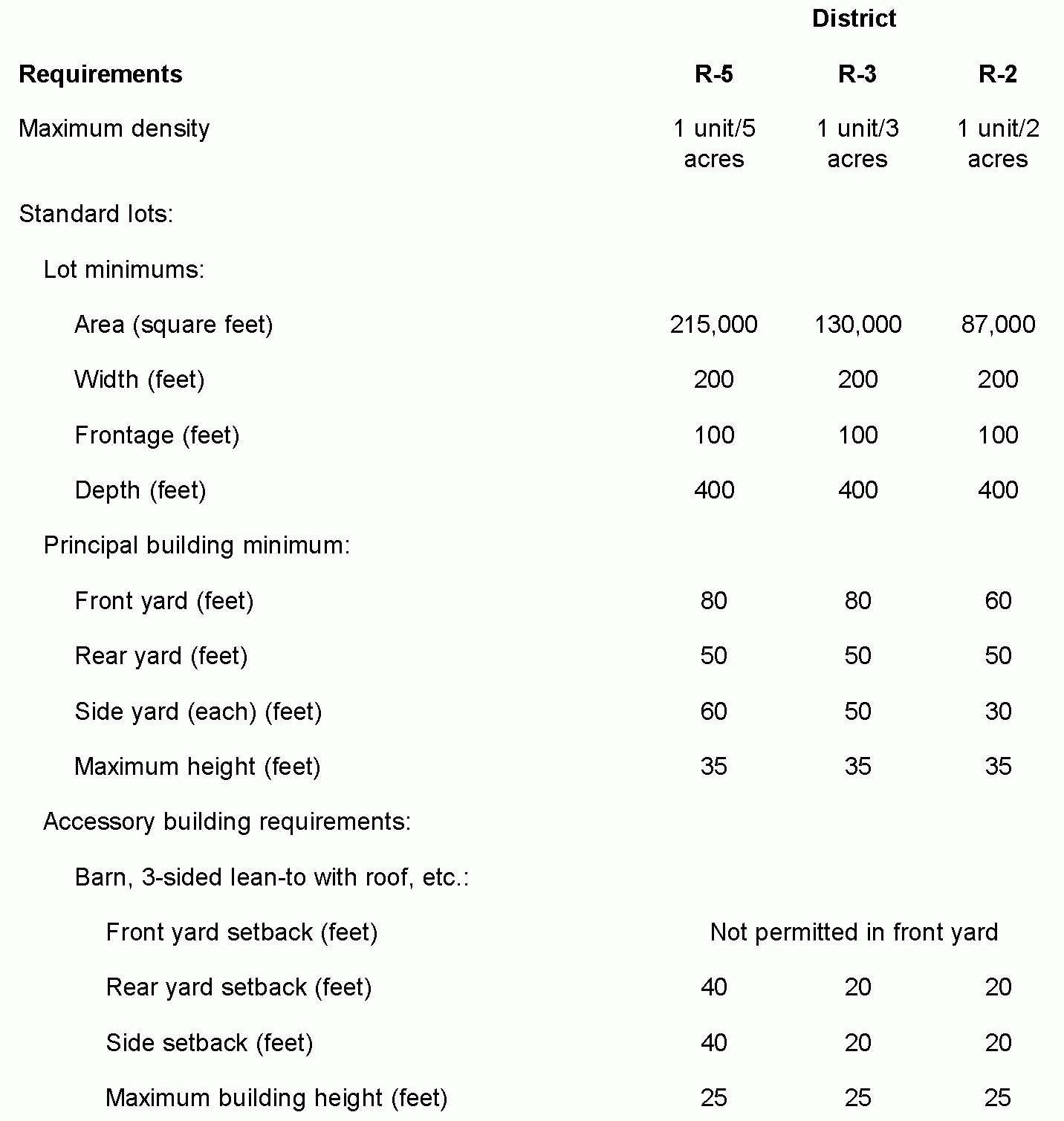
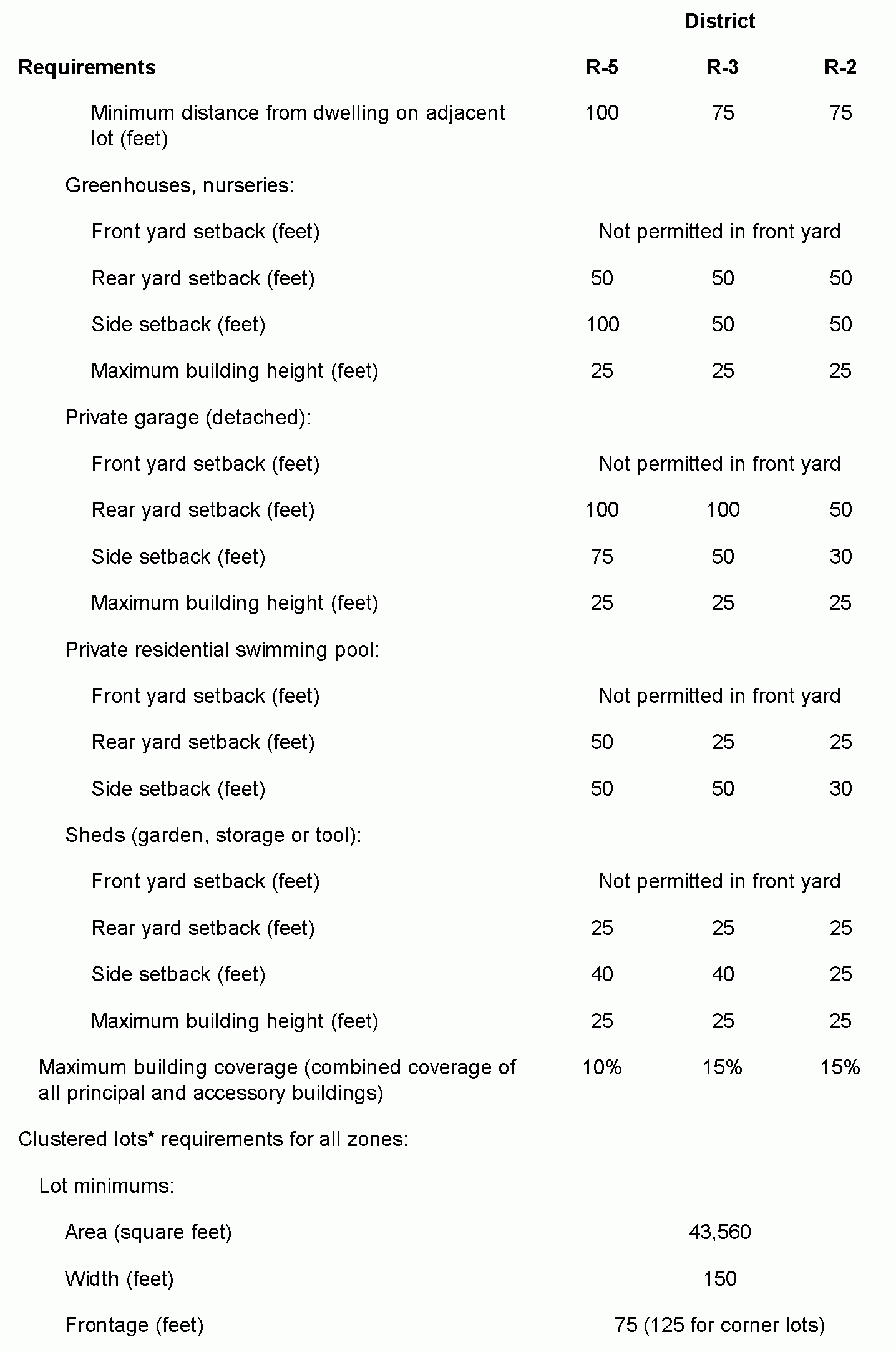
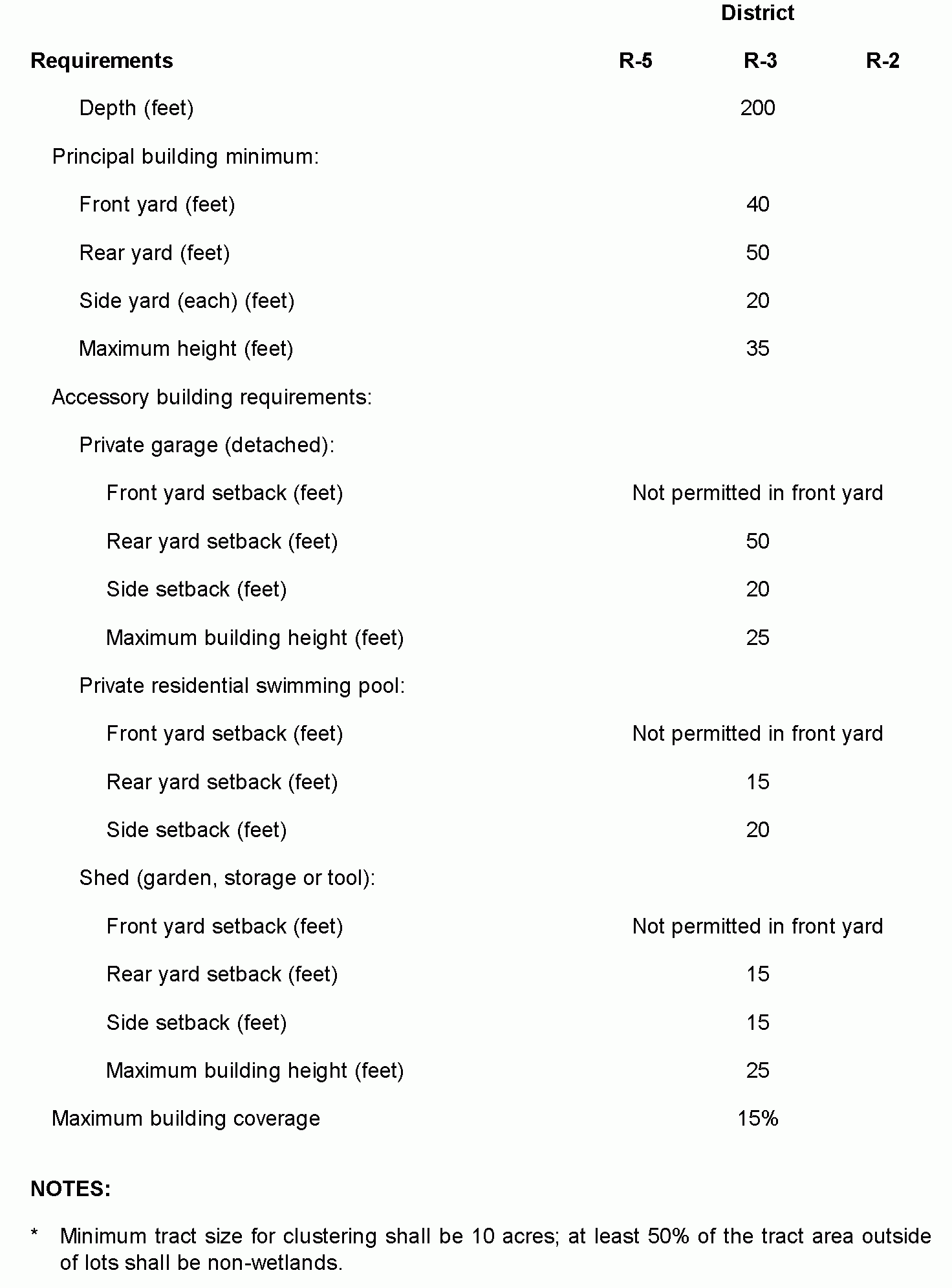
D. Density, area, yard and building minimum requirements are as follows:�
E. Any structure conforming as to use in Zone R-2, R-3 or R-5 that has received a certificate of occupancy or building permit or a structure conforming on a lot that has received preliminary subdivision approval as of the effective date of this chapter shall remain conforming under the regulations existing as of the date of such certificate of occupancy, building permit or approval.�

