
A. Inspection, testing and engineering administration fees. Prior to the signing of any final plat, issuance of a development permit or the start of construction of any improvements required by the provisions of this chapter, the developer shall deposit, by cash or certified check, with the Planning and Zoning Office an amount determined from the appropriate schedule under this chapter. Said amount shall be used to defray the cost of inspection, testing, engineering, administration and other costs and fees paid by the Township in connection with the inspection and acceptance of the installation of the required improvements.�
B. Inspection notice. All required improvements, except those utility improvements which are not the responsibility of the Township, shall be subject to inspection and approval by the Township Engineer, who shall be notified by the developer at least five days prior to the initial start of construction and again 48 hours prior to the resumption of work after any idle period exceeding one working day. All of the utility improvements shall be subject to inspection and approval by the owner of or agency controlling the utility, who shall be notified by the developer in accordance with the utilities requirements. No underground installation shall be covered until it is inspected and approved by the owner of or agency controlling the utility or by the Township Engineer in all other cases.�
C. Modification of improvements. At any time, whether as a result of his inspection of work underway or otherwise, the Township Engineer may recommend that the developer be required to modify the design and extent of the improvements required, notifying the Planning Board of his recommendations. The Planning Board shall, if it considers such modifications to be major or if requested by the developer or Township Engineer, take formal action to approve or disapprove such recommendations; provided, however, that it must first afford the developer an opportunity to be heard. If the Board takes no formal action within 30 days of such recommendations or where the developer has not requested formal Planning Board action, its approval will be assumed. Similarly, the Planning Board may grant or deny the developer permission to effect such modification upon his application and the Township Engineer's approval. In either event, where such modification is to be effected, the appropriate plat must be revised by the developer or his engineer to reflect such modification and sufficient copies thereof submitted to the administrative officer for distribution.�
D. General inspection requirements. All improvements, except as otherwise provided, shall be subject to inspection and approval by the Township Engineer. No underground installation shall be covered until inspected and approved by the Township Engineer or those agencies having jurisdiction over the particular installation. If such installation is covered prior to inspection, it shall be uncovered or other inspection means used, such as a television or other pipeline camera, as may be deemed necessary by the Township Engineer, and charges for such work will be paid for by the developer.�
E. Inspection not acceptance. Inspection of any work by the Township Engineer or his authorized representative shall not be considered to be final approval or rejection of the work but shall only be considered to be a determination of whether or not the specific work involved was being done to Township specifications or other required standards at the time of inspection. Any damage to such work or other unforeseen circumstances, such as the effect of the weather, other construction, changing conditions, settlement, etc., between the time of installation and the time that the developer wishes to be released from his performance guaranty shall be the full responsibility of the developer, and no work shall be considered accepted until release of the performance guaranty.�
F. Procedure on acceptance of public improvements. When the developer has constructed and installed the streets, drainage facilities, curbs, sidewalks, street signs, monuments and other improvements in accordance with Township regulations, standards and specifications and desires the Township to accept said improvements, he shall, in writing, addressed to and in a form approved by the Township Committee, with copies thereof to the Township Engineer, request the Township Engineer to make a semifinal inspection of said improvements. If the improvements have been constructed under a performance guaranty after approval of a final plat, the developer shall submit an as-built plan showing as-built grades, profiles and sections and locations of all subsurface utilities, such as French drains, combination drains, sanitary sewage disposal systems, both public and individual waterlines and control valves, gas lines, telephone conduits, monuments, iron property markers and any other utilities or improvements installed other than as shown on the approved final plat. Said as-built plan shall be certified to by a licensed New Jersey professional engineer. If any improvements are constructed prior to final plat approval, the final plat shall reflect all changes and as-built conditions and be so certified. Said as-built plan(s) shall be submitted on reproducible media.�
A. It shall be the responsibility of the developer to maintain the entire site or subdivision in a safe and orderly condition during construction. Necessary steps shall be taken by the developer to protect occupants of the site or subdivision and the general public from hazardous and unsightly conditions during the entire construction period. These steps shall include but are not limited to the following:�
(1) Open excavations shall be enclosed by fencing or barricades during nonconstruction hours. Movable barricades shall be equipped with yellow flashing hazard markers or other lighting during the hours or darkness.�
(2) The excavation of previously installed sidewalk and pavement areas which provide access to occupied buildings in the site or subdivision shall be clearly marked with signs and barricades. Alternate safe access shall be provided for pedestrians and vehicles to the occupied buildings.�
(3) Materials stored on the site shall be screened from the view of occupants of the subdivision or site and adjoining streets and properties.�
(4) Construction equipment, materials and trucks shall not be stored within 150 feet of occupied buildings in the site or subdivision and adjoining streets and properties during nonconstruction hours.�
(5) Safe vehicular and pedestrian access to occupied buildings in the site or subdivision shall be provided at all times.�
�
(6) Construction activities which create obnoxious and unnecessary dust, fumes, odors, smoke, vibrations or glare noticeable in occupied buildings in the subdivision or site and adjoining properties and streets shall not be permitted.�
(7) Construction activities which will result in damage to trees and landscaping in occupied buildings in the site or subdivision or adjoining properties shall not be permitted.�
(8) All locations and activities in the site or subdivision which present potential hazards shall be marked with signs indicating the potential hazard.�
(9) Unsightly construction debris, including scrap materials, cartons, boxes and wrappings must be removed daily at the end of each working day.�
(10) Whenever construction activities take place within or adjacent to any traveled way or interfere with existing traffic patterns in any manner, suitable warning signs, conforming to the requirements of the Uniform Manual on Traffic Control Devices, shall be erected and maintained by the developer.�
B. Construction trailers.�
(1) Construction trailers shall be permitted on the construction site, provided that they do not interfere with on-site construction, maneuverability of construction equipment, public ingress and egress to the site, site accessibility by emergency vehicles and sight visibility to the traveling public and do not impede the public health, safety and general welfare.�
(2) All construction trailers shall be removed from the site prior to release of the performance guaranty.�
C. Should the developer fail in his obligation to maintain the site or subdivision in a safe and orderly condition, the Township may, on five days' written notice, or immediately in the case of hazard to life, health or property, undertake whatever work may be necessary to return the site or subdivision to a safe and orderly condition and deduct the cost thereof from the 10% cash or certified check portion of the performance guaranty. Upon notice of such deduction, the developer shall, within 10 days, restore the full 10% cash balance, or his performance guaranty will be held to be void, and the Township may take action as if final plat approval had not been obtained.�
D. The Construction Official shall, upon receiving notice from the Township Engineer that a developer is in violation of this section, suspend further issuance of certificates of occupancy and building permits and may order cessation of work on any outstanding permits.�
A. No certificate of occupancy shall be issued for any use or building involving the installation of utilities or street improvements, parking areas, buffer areas, storm drainage facilities, other site improvements, the alteration of the existing grade on a lot or the utilization of a new on-site well or sanitary disposal system unless the Township Engineer or other appropriate authority shall have, where applicable, certified to the following:�
(1) Utilities and drainage. All utilities, including but not limited to water, gas, storm drains, sanitary sewers, electric lines and telephone lines, shall have been properly installed, and service to the lot, building or use from such utilities shall be available.�
(2) Street rights-of-way.�
(a) Grading of street rights-of-way. All street rights-of-way necessary to provide access to the lot in question shall have been completely graded, and all slope retaining devices or slope plantings shall have been installed.�
(b) Street rights-of-way. All street rights-of-way necessary to provide access to the lot, building or use in question shall have been completely graded, and all slope retaining devices or slope plantings shall have been installed.�
(3) Sidewalks. All sidewalks necessary to provide access to the lot, building or use in question shall have been properly installed.�
(4) Streets. Curbing and the bituminous base course of bituminous concrete streets or the curbing and pavement courses for portland cement concrete streets necessary to provide access to the proposed lot, building or use shall have been properly installed.�
(5) Curbing and parking areas. Curbing and the bituminous base course of parking areas necessary to provide access to the required number of parking spaces for the building or use in question shall have been properly installed.�
(6) Obstructions. All exposed obstructions in parking areas, access drives or streets, such as manhole frames, water boxes, gas boxes and the like, shall be protected by building to the top of such exposures with bituminous concrete as directed by the Township Engineer.�
(7) Screening, fences and landscaping. All required screening, fencing and/or landscaping related to the lot, building or use in question shall have been properly installed unless the Township Engineer shall direct the developer to delay the planting of screening and landscaping until the next planting season in order to improve the chances of survival of such plantings.�
(8) Site grading. All site grading necessary to permit proper surface drainage and prevent erosion of soils shall have been completed in accordance with an approved soil erosion and sediment con trol plan.�
(9) On-site wells. All on-site wells shall have been installed, tested and approved by the Ocean Cou nty Board of Health.�
�
(10) On-site sanitary disposal systems. All on-site sanitary disposal systems shall have been inst alled and approved by the Ocean County Board of Health.�
(11) Public water supply. Where the proposed lot, building or use is served by a public water supply, said supply shall have been installed and tested, and all required fire hydrants or fire connections shall have been installed and tested and approved by the Bureau of Fire Prevention.�
(12) Lighting. All outdoor lighting shall have been installed and shall be operational.�
(13) Street signs and traffic control devices. All street signs, paint lining and/or traffic control devices affecting the proposed lot, building or use, and required under the terms of approval of a subdivision or site plan or by federal, state, county or municipal rules, regulations or laws, shall have been installed.�
(14) Stabilized driveway.�
(15) Removal of construction debris.�
(16) Other. Any other conditions established for issuance of a certificate of occupancy by the Planning Board as a condition of final site plan approval shall be complied with.�
B. Prior to issuance of a certificate of occupancy, the applicant shall post a cash guaranty with the Township in an amount equal to the cost, to the Township, of constructing all uncompleted improvements not covered by performance guaranties previously posted.�
[Amended 8-24-2010 by Ord. No. 17-10] A maintenance guaranty shall be furnished by the developer upon release of the performance guaranty, acceptance of public improvements by the Township Committee and/or approval of site improvements by the Township Engineer. The developer may elect to furnish such maintenance guaranty either by maintaining on deposit with the Township the ten-percent cash or certified check portion of the performance guaranty provided in accordance with § 244-32 of this chapter or by a bond issued by a bonding company or surety company, or other type of surety acceptable to and approved by the Township Attorney and Township Council in an amount equal to 15% of the cost of improvement, as established by the Township Engineer. The maintenance guaranty shall begin with the release of the performance guaranty and shall run for a period of two years. The maintenance guaranty shall be to the effect that the applicant, developer, owner or user guaranties the complete maintenance of all improvements for a period of two years from the release of his performance guaranty. Should he fail in his obligation to properly maintain all improvements, the Township may, on 10 days' written notice, or immediately in the case of hazard to life, health or property, proceed with necessary repair or replacement of any unacceptable improvements and charge the cost thereof against the guaranty. At the end of the maintenance guaranty, the cash or certified check on deposit will be returned to the subdivider less any sums, properly documented by the Township, which have been expended to repair or replace any unsatisfactory improvements.�
[Added 2-9-1998 by Ord. No. 5-98; amended 8-14-2000 by Ord. No. 18-00] An applicant shall be required to dedicate proposed stormwater management systems to the Township and shall enter into an agreement with the Township to that end. Such agreement shall be a condition of final approval and shall be fully executed prior to release of performance guaranties, and acceptance of the stormwater management agreement shall require payment of the fee set forth in § 244-12K in consideration of the Township assuming all future maintenance of the stormwater management facilities. The form of agreement shall be approved by the Township Attorney. The agreement, upon execution, shall be recorded by the applicant in the office of the County Clerk. The applicant shall thereafter file a copy of the recorded agreement with the Township. Upon certification by the Township Engineer that the performance guaranty for the project may be released, acceptance of the stormwater management facilities by the Township shall be specifically stated in the resolution authorizing the guaranty release. The Township shall retain from the cash portion of the guaranty a sum equal to the maintenance fee approved as to amount by the Township Engineer in accordance with the formula in Article III of this chapter. In the event that the cash portion of the guaranty is less than the required maintenance fee, the developer shall post the deficit in cash. Any interim performance guaranty reductions authorized by the Township shall not be construed to mean that all or any part of the stormwater management system has been accepted by the Township nor shall any such interim reduction reduce the cash portion of the guaranty to an amount less than the required maintenance fee. It shall be the applicant's responsibility to maintain the stormwater management system during construction.�
[Added 9-9-2002 by Ord. No. 35-02] Except as otherwise provided by federal or state law or any regulations promulgated pursuant thereto, the following buffering standards shall apply on any stream corridor:�
A. Background.�
(1) Whereas, buffers adjacent to stream systems provide numerous environmental protection and resource management benefits which can include the following:�
(a) Storing and maintaining the chemical, physical and biological integrity of the water resources.�
(b) Removing pollutants delivered in urban stormwater.�
(c) Reducing erosion and controlling sedimentation.�
(d) Stabilizing stream banks.�
(e) Providing infiltration of stormwater runoff.�
�
(f) Maintaining base flow of streams.�
(g) Contributing the organic matter that is a source of food and energy for the aquatic ecosystem.�
(h) Providing tree canopy to shade streams and promote desirable aquatic organisms.�
(i) Providing riparian wildlife habitat.�
(j) Furnishing scenic value and recreational opportunity.�
(2) It is the desire of Jackson Township to protect and maintain the native vegetation in riparian and wetland areas by implementing specifications for the establishment, protection and maintenance of vegetation along all stream systems within our jurisdictional authority.�
B. Conflict with other regulations. Where the standards and management requirements of this buffer section are in conflict with other laws, regulations, and policies regarding streams, erodible soils, wetlands, floodplains, timber harvesting, land disturbance activities or other environmental protective measures, the more restrictive shall apply. However, this or section is not intended to, and shall not, supersede federal and state standards and regulations pertaining to the same subject matter that are in effect or adopted subsequent to the effective date of this section, including any and all regulations regarding the Pinelands zones or regarding freshwater wetlands. To the extent the provisions of this section and applicable federal and state regulations are in conflict, the federal and state regulations shall control.�
C. Intent. The purpose of this section is to establish minimal acceptable requirements for the design of buffers to protect the streams, wetlands and floodplains of Jackson Township; to protect the water quality of watercourses, reservoirs, lakes, and other significant water resources within Jackson Township; to protect Jackson Township's riparian and aquatic ecosystems; and to provide for the environmentally sound use of Jackson Township's land resources.�
D. Definitions. As used in this section, the following terms shall have the meanings indicated:�
ACTIVE CHANNEL The area of the stream channel that is subject to flows of at least two weeks' duration annually, and that includes the portion of the channel below where the floodplain flattens.�
BEST MANAGEMENT PRACTICES (BMPS) Conservation practices or management measures which control soil loss and reduce water quality degradation caused by nutrients, animal wastes, toxins, sediment and runoff.�
BUFFER A vegetated area, including trees, shrubs and herbaceous vegetation, which exists or is established to protect a stream system, lake, reservoir or coastal estuarine area. Alteration of this natural area is strictly limited.�
(1) The improvement of property for any purpose involving building;�
(2) Subdivision or the division of a tract or parcel of land into two or more parcels;�
(3) The combination of any two or more lots, tracts, or parcels of property for any purpose;�
(4) The preparation of land for any of the above purposes.�
NONPOINT SOURCE POLLUTION Pollution which is generated by various land use activities rather than from an identifiable or discrete source, and is conveyed to waterways through natural processes, such as rainfall, storm runoff or groundwater seepage rather than direct discharge.�
NONTIDAL WETLAND Those areas not influenced by tidal fluctuations that are inundated or saturated by surface water or groundwater at a frequency and duration sufficient to support, and that under normal circumstances does support, a prevalence of vegetation typically adapted for life in saturated soil conditions.�
ONE-HUNDRED-YEAR FLOODPLAIN The area of land adjacent to a stream that is subject to inundation during a storm event that has a recurrence interval of 100 years.�
POLLUTION Any contamination or alteration of the physical, chemical or biological properties of any waters that will render the waters harmful or detrimental to public health, safety or welfare; domestic, commercial, industrial, agricultural, recreational or other legitimate beneficial uses; livestock, wild animals or birds; fish or other aquatic life.�
STREAM CHANNEL Part of a watercourse either naturally or artificially created which contains an intermittent or perennial base flow of groundwater origin. Base flows of groundwater origin can be distinguished by any of the following physical indicators:�
(1) Hydrophytic vegetation, hydric soil or other hydrologic indicators in the area(s) where groundwater enters the stream channel in the vicinity of the stream headwaters, channel bed or channel banks.�
(2) Flowing water not directly related to a storm event.�
(3) Historical records of a local high groundwater table such as well and stream gauge records.�
STREAM ORDER A classification system for streams based on stream hierarchy. The smaller the stream, the lower its numerical classification. For example, a first order stream does not have tributaries and normally originates from springs and/or seeps. At the confluence of two first order streams, a second order stream begins, and so on.�
STREAMS Perennial and intermittent watercourses identified through site inspection and USGS maps. Perennial streams are those which are depicted on a USGS map with a solid blue line. Intermittent streams are those which are depicted or a USGS map with a dotted blue line.�
STREAM SYSTEM A stream channel, together with one or both of the following:�
�
(1) One-hundred-year floodplain; and/or�
(2) Hydrologically related nontidal wetlands.�
WATER POLLUTION HAZARD A land use or activity that causes a relatively high risk of potential water pollution.�
�
E. Applications.�
(1) This section shall apply to all proposed development except for that development which meets waiver criteria as outlined in Subsection I of this section.�
(2) This section shall apply to all timber harvesting activities, except those timber harvesting operations which are implementing a forest management plan which has been deemed to be in compliance with the regulations of the buffer ordinance and has received approval from the Pinelands Commission.�
(3) This section shall apply to all surface mining operations, except that the design standards shall not apply to active surface mining operations which are operating in compliance with an approved surface mining permit of the Pinelands Commission.�
F. Plan requirements.�
(1) In accordance with Subsection E of this section, a plan approved by the appropriate agency is required for all development, forest harvesting operations, surface mining operations and agricultural operations.�
(2) The plan shall set forth an informative, conceptual and schematic representation of the proposed activity by means of maps, graphs, charts or other written or drawn documents so as to enable the agency an opportunity to make a reasonably informed decision regarding the proposed activity.�
(3) The plan shall contain the following information:�
(a) A location or vicinity map.�
(b) Surveyed streams, springs, seeps, bodies of water and wetlands (include a minimum of 200 feet into adjacent properties).�
(c) Field delineated and surveyed forest buffers.�
(d) Limits of the ultimate one-hundred-year floodplain.�
(e) Soil survey map delineating slight, moderate and severe limitations.�
(f) A narrative of the species and distribution of existing vegetation within the buffer.�
(4) The buffer plan shall be submitted in conjunction with the required grading plan for any development, and the forest buffer should be clearly delineated on the final grading plan.�
(5) Permanent boundary markers shall be installed prior to final approval of the required clearing and grading plan.�
G. Design standards for forest buffers.�
(1) Forest buffer for a stream system shall consist of a forested strip of land extending along both sides of a stream and its adjacent wetlands, floodplains or slopes. The forest buffer width shall be adjusted to include contiguous sensitive areas, such as erodible soils, where development or disturbance may adversely affect water quality, streams, wetlands or other water bodies.�
(2) The forest buffer shall begin at the edge of the stream bank of the active channel.�
(3) The required width for all forest buffers (i.e., the base width) shall be a minimum of 75 feet, with the requirement to expand the buffer depending on stream order, percent slope; one-hundred-year floodplain; and wetlands or critical areas.�
(a) In third order and higher streams, add 25 feet to the base width.�
(b) Forest buffer width shall be modified if there are steep slopes which are within a close proximity to the stream and drain into the stream system. In those cases, the forest buffer width can be adjusted.�
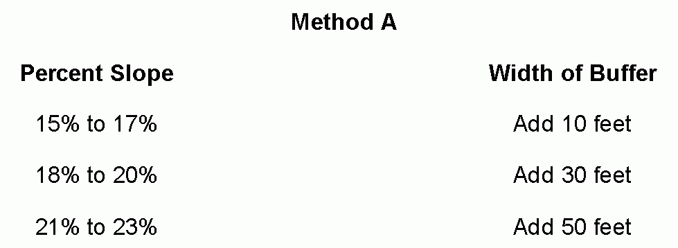
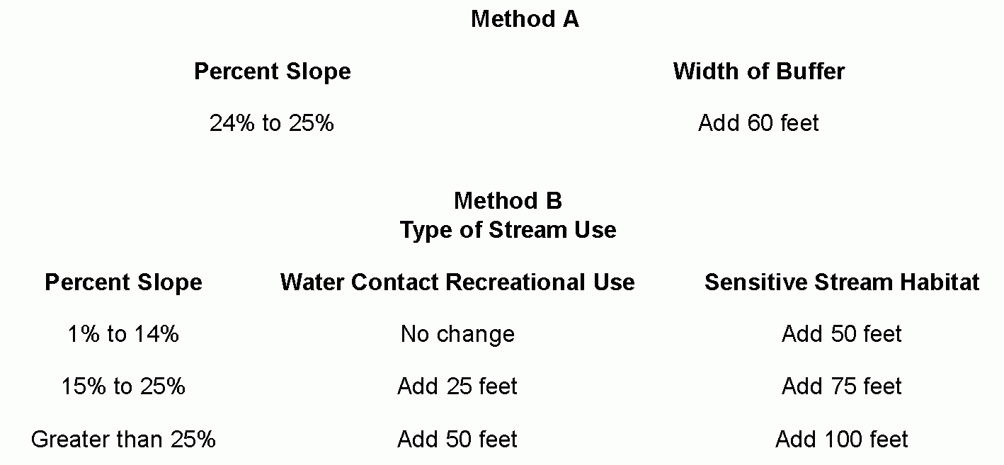
(c) Forest buffers shall be extended to encompass the entire one-hundred-year floodplain and a zone with minimum width of 25 feet beyond the edge of the floodplain.�
(4) Potential water pollution hazards.�
(a) The following land uses and/or activities are designated as potential water pollution hazards and must be set back from any stream or water body by the distance indicated below:�
[1] Storage of hazardous substances: 150 feet.�
�
[2] Above or below ground petroleum storage facilities: 150 feet.�
[3] Drainfields from on-site sewage disposal and treatment system (i.e., septic systems: 100 feet.�
[4] Raised septic systems: 250 feet.�
[5] Solid waste landfills or junkyards: 300 feet.�
[6] Confined animal feedlot operations: 250 feet.�
[7] Subsurface discharges from a wastewater treatment plant: 100 feet.�
[8] Land application of biosolids: 100 feet.�
(b) For development within 4,000 feet of any water supply intake, the setbacks should be doubled.�
(5) The forest buffer shall be composed of three district zones, with each zone having its own set of allowable uses and vegetative targets as specified in this section.�
[1] The function of the Streamside Zone is to protect the physical and ecological integrity of the stream ecosystem.�
[2] The Streamside Zone will begin at the edge of the stream bank of the active channel and extend a minimum of 25 feet from the top of the bank.�
[3] Allowable uses within this zone are restricted to:�
[a] Flood control structures.�
[b] Utility rights-of-way.�
[c] Footpaths.�
[d] Road crossings, where permitted.�
[4] The vegetative target for the Streamside Zone is undisturbed native vegetation.�
[1] The function of the Middle Zone is to protect key components of the stream and to provide distance between upland development and the Streamside Zone.�
�
[2] The Middle Zone will begin at the outer edge of the Streamside Zone and extend a minimum of 50 feet, plus any additional buffer width as specified in Subsection G(5)(c).�
[3] Allowable uses within the Middle Zone are restricted to:�
[a] Biking or hiking paths.�
[b] Stormwater management facilities.�
[c] Recreational uses as approved by the reviewing board.�
[d] Limited tree clearing with approval from reviewing board.�
[4] The vegetative target for the Middle Zone is mature native vegetation adapted to the region.�
[1] The function of the Outer Zone is to prevent encroachment into the forest buffer and to filter runoff from residential and commercial development.�
[2] The Outer Zone will begin at the outward edge of the Middle Zone and provide a minimum width of 25 feet between Zone 2 and the nearest permanent structure.�
[3] There shall be no septic systems, permanent structures or impervious cover, with the exception of paths, within the Outer Zone.�
[4] The vegetative target for the Outer Zone may vary, although the planting of native vegetation should be encouraged to increase the total width of the buffer.�
H. Buffer management and maintenance.�
(1) The forest buffer, including wetlands and floodplains, shall be managed to enhance and maximize the unique value of these resources. Management includes specific limitations on alteration of the natural conditions of these resources. The following practices and activities are restricted within Zones 1 and 2 of the forest buffer, except with approval by the reviewing board.�
(a) Clearing of existing vegetation.�
(b) Soil disturbance by grading, stripping or other practices.�
(c) Filling or dumping.�
(d) Drainage by ditching, underdrains or other systems.�
(e) Use, storage or application of pesticides, except for the spot spraying of noxious weeds or nonnative species.�
(f) Housing, grazing or other maintenance of livestock.�
(g) Storage or operation of motorized vehicles, except for maintenance and emergency use.�
(2) The following structures, practices and activities ate permitted in the forest buffer, with specific design or maintenance features subject to the review of the approving board and the NJDEP.�
(a) Roads, bridges, paths and utilities:�
[1] An analysis needs to be conducted to ensure that no economically feasible alternative is available.�
[2] The right-of-way should be the minimum width needed to allow for maintenance access and installation.�
[3] The angle of the crossing shall be perpendicular to the stream or buffer in order to minimize clearing requirements.�
[4] The minimum number of road crossings should be used within each development.�
[5] Permitted utilities shall include wastewater pumping stations.�
(b) Stormwater management:�
[1] An analysis needs to be conducted to ensure that no economically feasible alternative is available and that the project is either necessary for flood control or significantly improves the water quality or habitat in the stream.�
[2] In new developments, on-site and nonstructural alternatives will be preferred over larger facilities within the stream buffer.�
[3] When constructing stormwater management facilities (i.e., BMPs), the area cleared will be limited to the area required for construction and adequate maintenance access as outlined in the most recent edition.�
[4] Alternative stormwater management facilities shall be considered to encourage the design of facilities that are sufficient to capture a two-year storm event.�
(c) Stream restoration projects, facilities and activities as approved are permitted within the forest buffer.�
(d) Water quality monitoring and stream gauging are permitted within the forest buffer, as approved.�
(e) Individual trees within the forest buffer may be removed which are in danger of falling, causing damage to dwellings or other structures or causing blockage of the stream.�
(3) All plats prepared for recording and all right-of-way plats shall clearly:�
(a) Show the extent of any forest buffer on the subject property by metes and bounds.�
(b) Label the forest buffer.�
(c) Provide a note to reference any forest buffet stating: "There shall be no clearing, grading, construction or disturbance of vegetation except as permitted by the age ncy."�
(d) Provide a note to reference any protective covenants governing all forest buffers areas stating: "Any forest buffer shown hereon is subject to protective covenants which may be found in the land records and which restrict disturbance and use of the se areas.�
(4) All forest buffer areas shall be maintained through a declaration of protective covenant, which is required to be submitted for approval by the board. The covenant shall be recorded in the land records and shall run with the land and continue in perpetuity.�
(5) All lease agreements must contain a notation regarding the presence and location of protective covenants for forest buffer areas and which shall contain information on the management and maintenance requirements for the forest buffer for the new property owner.�
(6) An offer of dedication of a forest buffer area to the agency shall not be interpreted to mean that this automatically conveys to the general public the right of access to this area.�
(7) The Township shall inspect the buffer annually and immediately following severe storms for evidence of sediment deposition, erosion or concentrated flow channels and corrective actions taken to ensure the integrity and functions of the forest buffer.�
(8) Forest buffer areas may be allowed to grow into their vegetative target state naturally, but methods to enhance the successional process such as active reforestation may be used when deemed necessary to ensure the preservation and propagation of the buffer area. Forest buffer areas may also be enhanced through reforestation or other growth techniques as a form of mitigation for achieving buffer preservation requirements.�
I. Waivers.�
(1) This section shall apply to all proposed development except for that development which prior to the effective date of this section:�
(a) Is covered by a valid, unexpired plat in accordance with development regulations.�
(b) Is covered by a current executed public works agreement.�
(c) Is covered by a valid unexpired building permit.�
(d) Has been accepted to apply for a building permit.�
(e) Has been granted a waiver in accordance with current development regulations.�
(2) Waivers may be granted by the reviewing board under the following conditions:�
(a) Those projects or activities where it can be demonstrated that strict compliance with the section would result in practical difficulty.�
(b) Those projects or activities serving a public need where no feasible alternative is available.�
(c) The repair and maintenance of public improvements where avoidance and minimization of adverse impacts to nontidal wetlands and associated aquatic ecosystems have been addressed.�
(d) For those developments which have had buffers applied in conformance with previously issued requirements.�
(e) The buffer width may be relaxed and the buffer permitted to become narrower at some points as long as the average width of the buffer meets the minimum requirement. This averaging of the buffer may be used to allow for the presence of an existing structure or to recover a lost lot, as long as the Streamside Zone (Zone 1) is not disturbed by the narrowing and no new structures are built within the one-hundred-year floodplain.�
(3) The applicant shall submit a written request for a waiver. The application shall include specific reasons justifying the waiver and any other information necessary to evaluate the proposed request. The agency may require an alternatives analysis that clearly demonstrates that no other feasible alternatives exist and that minimal impact will occur as a result of the project or development.�
(a) In granting a request for a variance, the board may require site design, landscape planting, fencing, the placement of signs and the establishment of water quality best management practices in order to reduce adverse impacts on water quality, streams, wetlands and floodplains.�

