
A. Required documents. Prior to issuance of a certificate of completeness or scheduling of a final plat of a major subdivision for public hearing before the Planning Board, the Administrative Officer shall determine that the following has been submitted in proper form:�
(1) (Reserved)�
(2) Application for Final Ocean County Planning Board approval.�
�
(3) Application for final Dover Sewerage Authority approval.�
(4) Application for land disturbance permit.�
(5) Application for Bureau of Fire Prevention approval.�
(6) Application for tree removal permit, where required.�
(7) Traffic Safety Officer's report, where required.�
(8) Application for municipal and/or state wetlands approval, where required.�
(9) Application for floodplain encroachment permit, where required.�
(10) Application for stream encroachment permit, where required.�
(11) Where applicable, a copy of the permit issued or, if the permit has not been issued, the application filed with the New Jersey Department of Environmental Protection, under the Coastal Area Facility Review Act, and copies of the environmental impact statement and any attachments thereto filed in accordance with the provisions of the Act, or, in the alternate, a statement issued by the Department of Environmental Protection that the proposed development is exempt from the Act.�
(12) A certificate of title, which may be in letter form, signed by a member of the New Jersey Bar or by a title officer or authorized agent of a title insurance company licensed to do business in the State of New Jersey, which certificate shall confirm that the owner of the premises in question is the owner as shown on the plat.�
(13) Other submittals that may be required by the Planning Board Engineer, Planning Board or federal, state or local law.�
(14) Unless waived by the Planning Board, a formal request, in appropriate statutory form, requesting that the applicable provisions of Title 39 of the New Jersey Revised Statutes be made applicable to the site in order to permit police regulation of traffic control devices prior to acceptance of streets.�
(15) Required application fees.�
(16) Ten copies of a plat and attachments meeting the requirements set forth below. [Amended 2-9-1982 by Ord. No. 2(168; 5-22-1984 by Ord. No. 2244-84; 9-24-1996 by Ord. No. 3196-96; 12-9-2003 by Ord. No. 3843-03]�
�
B. Plat requirements.�
(I) General requirements. A final plat may, for all or any portion of an approved preliminary plat, be submitted to the Planning Board within three years of the date of approval of the preliminary plat. In general, all requirements set forth in this chapter for tentative plats shall apply to fnal plats with the addition of the specific additional requirements set forth herein.�
(a) A final plat shall be drawn at a scale of not less than 100 feet to the inch, shall conform to the provisions of Chapter 141 of the Laws of 1960 of the State of New Jersey, as amended and supplemented, and shall include or be accompanied by the information specified herein.�
(b) All dimensions, both linear and angular, of the exterior boundaries of the subdivision and all lots and all lands reserved or dedicated for public use shall balance, and their description shall close within a limit of error of not more than one part in 10,000 �
(2) Purpose of final plat. A final plat and supporting drawings and documents for a proposed subdivision constitute the complete and fully detailed and documented development of the subdivision proposal and becomes the basis for the construction of the subdivision and inspection by the Township Engineer, other officials and Planning Board. The portion of the plat intended for filing must be recorded at the County Clerk's office to have legal status.�
(3) Title block. The title block shall appear on all sheets and shall include:�
(a) Title of "Final Plat - Major Subdivision."�
(b) Development name, if any.�
(c) Tax Map sheet, block and lot number(s) of the tract to be subdivided as shown on the latest Township Tax Map, the date of which shall also be shown.�
(d) Date of original and all revisions.�
(e) Names and addresses of owner and subdivider, so designated.�
(f) The name(s), signature(s), address(es) and license number(s) of the engineer and land surveyor who prepared the map. The plat shall bear the embossed seal of said engineer and land surveyor.�
(4) The final plat shall be based on a monumented, current, certified boundary survey. The date of the survey and the name of the person making the same shall be shown on the map. If 12 months or more has passed since the date of (or date of last recertification of) the survey, it shall be recertified and, if necessary, brought up-to-date. Any necessary revisions from the survey used as a base for the tentative plat shall be specifically noted.�
(5) A schedule shall be placed on the map indicating the acreage of the tract, the number of lots, the zone, the dimensions and percentage of recreation acreage provided.�
(6) All design information submissions required by the provisions of the improvements and design standards portions of this chapter shall accompany the final plat.�
(7) A grading plan showing existing and proposed grading contours at one-foot intervals throughout the tract, except that if slopes exceed 5%, a two-foot interval may be used, and if they exceed 10%, a five-foot interval is permissible. Data shall be United States Coast and Geodetic Survey data (MSL=0), and the source of data shall be noted. In addition to proposed grading contours, sufficient additional spot elevations shall be shown to clearly delineate proposed grading, including corner elevations of buildings and first floor and basement elevations.�
(8) The limits of all areas of proposed cuts and fills, exclusive of excavations for basements, shall be clearly designated.�
(9) On-site drainage plan.�
(a) The drainage plan shall be presented in graphic form which shall clearly show the street and lot layout and those items which are pertinent to drainage, including existing and proposed contours as previously required.�
(b) The plan shall outline each area contributing to each inlet.�
(c) All proposed drainage shall be shown with pipe types and sizes, invert and grate or rim elevations, grades and direction of flow. The direction of flow of all surface waters and of all streams shall be shown.�
(d) The drainage plan shall be accompanied by complete drainage calculations made in accordance with standards set forth herein.�
(10) Off-site drainage plan. The final plat shall also be accompanied by an off-site drainage plan prepared in accordance with the following standards:�
(a) The plan shall consist of an outline of the entire drainage basin in which the property to be subdivided is located. The terminus of the basin and existing ground contours or other basis for determining basin limits shall be shown.�
(b) The pertinent off-site existing drainage shall be shown with elevations of inverts and grade to the nearest 0.1 foot.�
(c) To the extent that information is available and may be obtained from the county or municipal engineer(s), any existing plans for drainage improvements shall be shown.�
(d) In the event that a temporary drainage system is proposed, full plans of that system shall be shown.�
(e) The off-site drainage plans shall be accompanied by profiles of all proposed drainage, showing existing and proposed finished grades, channel section details; pipe sizes, types, inverts, crowns and slopes; all proposed structures and connections; and design hydraulic grade lines for all conduits designed to carry 40 or more cubic feet per second. Cross sections at intervals not exceeding 100 feet shall be shown for all open channels.�
(11) Center-line profiles of all proposed streets showing:�
(a) Existing and proposed finished grades and slopes.�
(b) Pipe sizes, slope, type, inverts and grate or rim elevations of drainage and sanitary sewage facilities.�
(12) Where required by the Township Engineer, cross sections of proposed streets to at least 10 feet outside of any grading limit at intervals of at least every 100 feet, of all proposed streets.�
(13) The location, caliper and type of the following may be required to be shown on the plat for a tree removal permit: [Amended 9-14-1982 by Ord. No. 2116]�
(a) Living deciduous trees having a trunk of six-inch diameter or more at breast height.�
(b) All living coniferous trees having a trunk of six-inch or more diameter at breast height.�
(c) All living dogwood (Corpus florida) or American holly (Ilex opaca) trees having a trunk of one-inch or greater diameter at breast height.�
(d) All native laurel (Kalmia latifolia) shrubs having a root crown of three inches or greater measured at the soil or surface level.�
(14) The number, location and species of all proposed shade trees or other plantings.�
(15) Detailed utility layouts, specifications and cross sections (sewers, water, gas, electric, telephone, etc.), showing feasible connections to any existing or proposed utility systems; provided, however, that detailed layouts of gas, electric and telephone lines are not required. An indication of these on a typical road cross section shall be sufficient. Layouts shall include proposed locations of streetlights and fire hydrants. If private utilities are proposed, they shall comply with all local, county and state regulations.�
(16) The tops of the banks and boundaries of the floodways and flood hazard areas of all existing watercourses, where such have been delineated, or the limits of alluvial soils where the boundaries of floodways and flood hazard areas have not been determined, and/or such other information as may assist the Planning Board in the determination of floodway and flood hazard area limits. In cases where all or a portion of a subdivision within the R-800 Zone is located in an unnumbered "A" Zone as shown on the Flood Insurance Rate Maps of the Federal Insurance Administration, the applicant shall undertake and submit such studies as are necessary to determine the base flood elevation.�
(17) Tract boundary lines, right-of-way lines of streets, easements and other rights-of-way; land to, be reserved or dedicated to public use, all lot lines and site easement lines, with accurate dimensions and bearings and radii, tangents, chords, arcs and central angles of all curves and all front, rear and side (or yard) setback lines.�
(18) All monuments in accordance with Chapter 141 of the Laws of 1960 of the State of New Jersey, including all monuments found, monuments set and monuments to be set, and an indication of monumentation found and reset.�
(19) Certificate of engineer or land surveyor as to accuracy of the details of the plat.�
(20) Lot and block numbers shown on the final plat shall conform to the Township Tax Map, or proposed revisions thereof, and shall be obtained by the applicant's engineer from the Township Engineer. Proposed house numbers shall also be obtained from the Township Engineer and shall be shown encircled on the final plat, or one of the attachments thereto. The Township Engineer shall not affix his signature to the final plat unless the applicant has fully complied in this regard.�
(21) Subdivision names and street names shown on the final plat shall not be the same or similar to any name of any existing subdivision or street in the Township of Dover and shall be approved by the Township Engineer.�
(22) The location of areas dedicated for park and recreation facilities or common open space as approved by the Planning Board.�
(23) Unless waived by the Planning Board, a detailed plan setting forth the type and location of all traffic control and regulatory devices. This plan shall have been approved by, or in the opinion of the Township Engineer be likely to be approved by, the New Jersey Department of Transportation. This plan shall be prepared in consultation with the Township Engineer and the Dover Township Police Department and shall provide for all appropriate traffic control measures necessary for the health, safety, convenience and well-being of those occupying, or likely to occupy, the subdivision between final approval and final acceptance.. This plan shall be accompanied by the formal request referred to in § 348-6.11A(14).�
(24) Such other information as the Planning Board and/or Planning Board Engineer may request during review.�
(25) All plats submitted to the Planning Board for final approval shall comply with the provisions of the Map Filing Law (N.J.S.A. 46:23-9.9 et seq.) and shall not contain more than 100 lots. Simultaneous consideration of approval of multiple final sections, each containing not more than 100 lots, may be entertained by the Board.�
(26) Sectionalization of final plats shall be in conformance with the sectionalization and staging plan, if any, approved with the preliminary plat.�
C. Conditions of approval. Any approval of an application for development of a final plat of a major subdivision shall be subject to the following conditions being satisfied within a period of time specified by the Planning Board, prior to the signing of the plat or issuance of a development permit.�
(1) Proof of payment of any outstanding real estate taxes."' [Added 6-11-1985 by Ord. No. 2329-85]�
(2) Submission of additional prints of the plat map and attachments for distribution, if required.�
(3) Publication of a notice of the decision by the applicant.�
(4) Final Ocean County Planning Board approval, if not previously obtained.�
(5) Final Dover Sewerage Authority approval, if not previously obtained.�
(6) Payment of required reproduction fees.�
(7) Issuance of a land disturbance permit.�
(8) Bureau of Fire Prevention approval, if not previously obtained.�
(9) Issuance of a tree removal permit, if not previously obtained.�
(10) Granting of state or municipal wetlands permit, if required.�
(11) Granting of a floodplain permit, if required.�
(12) Certification of approval of plans for drainage or watercourse diversions by the State of New Jersey, Department of Environmental Protection, where required.�
(13) Granting of a Coastal Area Facility Review Act (CAFRA) permit, where required.�
(14) Granting of drainage and/or access permits by the New Jersey Department of Transportation, where required.�
(15) Approval of any required riparian grants or licenses.�
(16) Granting of any required construction permits.�
(17) Posting of required performance guaranties. In the event that the development does not propose the construction of a new roadway, the Planning Board may, upon favorable recommendations of the Township Engineer, permit the installation and approval of, or posting of performance guaranties for the installation of, any improvements required by the Planning Board. [Amended 5-22-1984 by Ord. No. 2244-84]�
(18) Payment of required inspection fees. In the event that the development does not propose the construction of a new roadway, the Planning Board may, upon favorable recommendation of the Township Engineer, reduce the required inspection fees as indicated in
(19) Evidence of a comprehensive general liability insurance policy in an amount not less than $300,000 per occurrence, identifying and saving harmless the Township of Dover and its agencies, employees and agents from any liability for any acts of the subdivider or his agents, contractors or employees in the implementing of the approved subdivision. The insurance policy shall provide for 30 days' notice to the Township prior to cancellation. It shall be a violation of this chapter for any property owner, subdivider or builder to carry on the construction of a subdivision without having current valid evidence of insurance on file. [Amended 5-22-1984 by Ord. No. 2244-84]�
(20) Submission of an agreement from the applicant authorizing proposed roadways to be governed by State Statute Title 39, Subtitle I. [Amended 6-11-1985 by Ord. No. 2329-85]�
(21) Any other conditions which may be imposed by the Planning Board or may be required by federal, state or local law.�
(22) Any final plat major subdivision approval shall expire unless the plat is filed with the county recording officer in compliance with Chapter 141 of the Laws of 1960, as amended and supplemented, within two years of the date of approval or such further time as provided in accordance with § 348-3.1J(7)(d) herein. [Added 5 13-1992 by Ord. No. 2911-921�
�
(23) Proof of filing of a developers agreement in the Ocean County Clerk's Office. Prior to filing, the developer must execute the agreement with the Township governing body to guarantee the installation of improvements. [Added 12-9-2003 by Ord. No. 3843-03]�
D. Certification. In the event that the application for development for a final plat of a major subdivision is approved, a certification to that effect in this form: [Amended 9-24-1996 by Ord. No. 3196-96]�
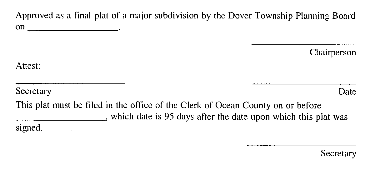
shall be endorsed on the plat, and the original reproducible thereof shall be provided to the Planning Board by the applicant. Said original shall be signed by the Chairperson and Secretary or Assistant Secretary of the Planning Board and the Township Engineer (as to the Map Filing Law certification) after they receive a certification from the Administrative Officer that all conditions of approval have been satisfied. After signature, the plat shall be reproduced as provided for in § 348-6.4 of this chapter, and the signed original shall be returned to the applicant for filing.�
E. Filing of approved plat. If the applicant desires to proceed with a subdivision for which final approval has been granted, he shall file with the county recording officer a plat map drawn in compliance with Chapter 141 of the Laws of 1960, as amended and supplemented, within 95 days from the date upon which the plat was signed by the Planning Board Chairman and Secretary or Assistant Secretary. The applicant shall, within one week after filing the subdivision with the county recording officer, notify, in writing, the Township Engineer of the date of filing of the subdivision with the county recording officer and the case and sheet or page number for the filed map. A duplicate tracing of the filed map indicating thereon the filing date shall be obtained from the county recording officer by the Township Engineer, who shall distribute copies of the filed map to appropriate municipal officials. In the event that the subdivider fails to so file within the period allowed, the approval of the plat shall expire unless such time is extended by the Planning Board in accordance with § 348-3.IJ(6)(b) herein. [Amended 5-13-1992 by Ord. No. 2911-92]�
F. Applicant's rights upon approval. Approval of a final plat shall confer upon the applicant all the rights set forth in N.J.S.A. 40:55D-52 and § 348-3.IJ(7) of this chapter.�
G. Display of final plat. The subdivider or his agent shall keep a clear and legible copy of the approved final plat in plain view in a prominent location in his offices and/or salesrooms from which sales in the approved subdivision are made so that prospective purchasers may have the opportunity to learn the special conditions, if any, under which approval was given.�

