
Where a property borders on more than one (1) street (i.e. corner or through lot) the determination of the lot's frontage shall be at the option of the owner or developer and shall be so designated on all maps and official records For purposes of determining compliance with zone standards, only the designated frontage shall be considered as frontage All driveway and utility connections shall be from this designated frontage, except for corner lots with two (2) conforming frontages which may utilize either frontage for driveway and utility connections. The remaining street right-of-way lines shall be considered lot lines Nothing in this section is intended to in any way modify the definition of front yard (Ord #13-96, 1)
**Webmasters Note: The previous subsection has been amended as per Ordinance No. 8-2000.
a. Statement of Purpose.
1. It is the purpose of this subsection to establish regulations for development within critical areas of steep slopes and to prevent inappropriate development in areas of excessive slopes.
2. These special development controls are provided in recognition of the potentially negative impacts associated with the removal of vegetative cover, the disturbance of the soil by excavation or fill, and the construction of buildings, structures, roadways and associated site disturbances within these areas of steep slopes in the Township of Denville which will cause an increase of surface water runoff, soil erosion and siltation, with the resultant pollution of streams as well as the potential danger of flooding and water damage and thereby having the potential of endangering public and private property and life.
3. Development on the slopes can create additional hazards to the lives and property of those having structures on the slopes and below them.
4. The most appropriate method of alleviating such conditions is through the regulation of the removal of such vegetation and soil disturbance, construction and development.
5. It is determined that the special and immediate public interest in these slopes justifies the regulation of property located thereon as provided in this subsection which is the exercise of the police power of the township for the protection of persons and property of its inhabitants and for the preservation of the public health, safety and general welfare.
6. It is not the purpose of this subsection to establish densities but rather to control development within appropriate areas.
b. Applicability.
1. All applications for development as defined in the Municipal Land Use Law, N.J.S.A. 40:55D-1 et seq., except for activities set forth in subsection b.2. below shall be required to prepare a steep slope map and comply with the restrictions outlined in this section. Approval of the steep slope map shall be granted by the appropriate board as part of a development application and/or prior to the disturbance of any area of steep or excessive slopes.
2. Prior to the issuance of a building permit for a detached one or two dwelling-unit building on a single lot containing steep or excessive slopes, or prior to the disturbance of any soil or vegetation on a single lot containing steep or excessive slopes on which a detached one or two dwelling-unit building is located, [except for re-grading and landscaping], a steep slope map shall be submitted to the Planning Board for its review and recommendation to the construction official. If a variance from the provisions of this subsection 19-5.729 is requested by the applicant in connection with a single lot on which a detached one or two dwelling-unit building is located or proposed to be constructed, the construction official or zoning officer, as the case may be, shall refer the application directly to the Zoning Board of Adjustment.
c. Definitions. For the purpose of this subsection, certain terms are defined and shall be construed as follows:
DEVELOPMENT AREA shall mean that part of the permitted building envelope which is intended to be used for a structure and is so designated for soil disturbance necessary for the development of the lot.
EXCESSIVE SLOPE shall mean any slope which has a grade of twenty-five (25%) percent or more.
MINOR TOPOGRAPHIC VARIATION shall mean that slopes of twenty-five (25%) percent or more shall not occur in more than ten (10%) percent of any area of the lot.
STEEP SLOPE shall mean any slope which has a grade greater than or equal to fifteen (15%) percent but less than twenty-five (25%) percent.
d. Steep Slope Map Details. A steep slope map shall include the following information:
1. A plan shall be drawn by a licensed professional engineer at a scale of. not less than one inch equals thirty feet, (1"=30').
2. Existing and proposed grades represented by contours at two (2') foot intervals when grades are below thirty (30%) percent, at five (5') foot intervals when grades are thirty (30%) percent or more, and by spot elevations when flatness of the plot makes the use of contours impractical., Existing contours shall be shown for a distance of twenty-five (25) feet beyond the plot limits.
3. Slope classification map indicating existing grade categories as follows: 0 to 14.99%; 15% to 19.99%; 20% to 24.99%; 25% to 29.99%; and slopes 30% or more. A table indicating the degree of slope disturbance, pursuant to subsection §19-5.729e.1 of this section shall be provided.
4. Existing and proposed elevations at all plot corners, building corners, centers of swales, disposal bed corners, and at the locations of all changes in direction of storm water flow.
5. Proposed elevations at changes in grade of driveways and walks, as well as the 9 proposed and existing curb, sidewalk, and road elevations at the plot corners and at changes in grades.
6. Location and details of swales and other means for the disposition of all storm water.
7. The location of the proposed dwelling including the location of the garage, all overhangs, the number of stories of the dwelling, and the proposed elevation of all floors, cellar and garage and all setback distances.
8. The location of proposed pedestrian and vehicular facilities including walks, roads, drives or parking areas with both vertical and horizontal alignments properly dimensioned.
9. Type and width of existing pavement and width of right-of-way on road on which plot fronts.
10. Metes and bounds of all property lines, monumentation at all property corners and location of any existing fences, hedges, etc., along the property lines.
12. Drainage study as applicable or required by the Planning Board and/or the Township Engineer.
13. Location of all buildings on adjoining lots within two hundred (200') feet.
14. The proposed elevations of the levels of land above and below retaining walls as well as top of wall elevations.
15. The location of all existing and proposed landscaping including trees having a diameter of 3" or greater as measured at a point one foot above the ground, shrubs and ground covers with type and size of trees or shrubs and specifications for ground covers.
16. The disposition and extent of topsoil to be removed or backfilled.
17. The disposition and extent of all other soil to be removed and backfilled.
18. The plans and specifications for any proposed retaining walls, steps, fences or other protective structures.
e. Steep Slope Map Review Procedures.
1. The procedures applicable to the review of subdivisions, site plans and variance applications shall apply to the review of steep slope maps in connection with site plan and subdivision applications.
2. For all other applications for review of steep slope maps, including applications pursuant to subsection 19-5.729.b.2, the following procedures shall apply:
(a) Fourteen (14) copies of all steep slope maps shall be submitted twenty-one (21) days prior to the regular Board meeting at which they are to be considered together with an application and a fee of forty ($40) dollars per lot.
(b) Copies of the steep slope map shall be forwarded to the Denville Environmental Commission and the Morris County Soil Conservation District for their review and recommendations and no action shall be taken on said application for a period of thirty (30) days or until reports are received from these agencies, whichever is sooner.
(c) Copies of the application and steep slope map shall be forwarded for review and recommendation to certain Township personnel and other experts as may be deemed appropriate by the Board hearing the application. Such reports shall be submitted to the appropriate Board within thirty (30) days of the date of application.
3. Notice of an application for steep slope map review and approval shall not be required unless notice would otherwise be required pursuant to the Municipal Land Use Law.
f. Development Regulations. Within any area of steep or excessive slopes, no soil or vegetation shall be disturbed nor shall any building or structure be erected, constructed or substantially enlarged or lot created unless and until it can be demonstrated by information, plans and studies furnished by the applicant that the following, requirements can be met:
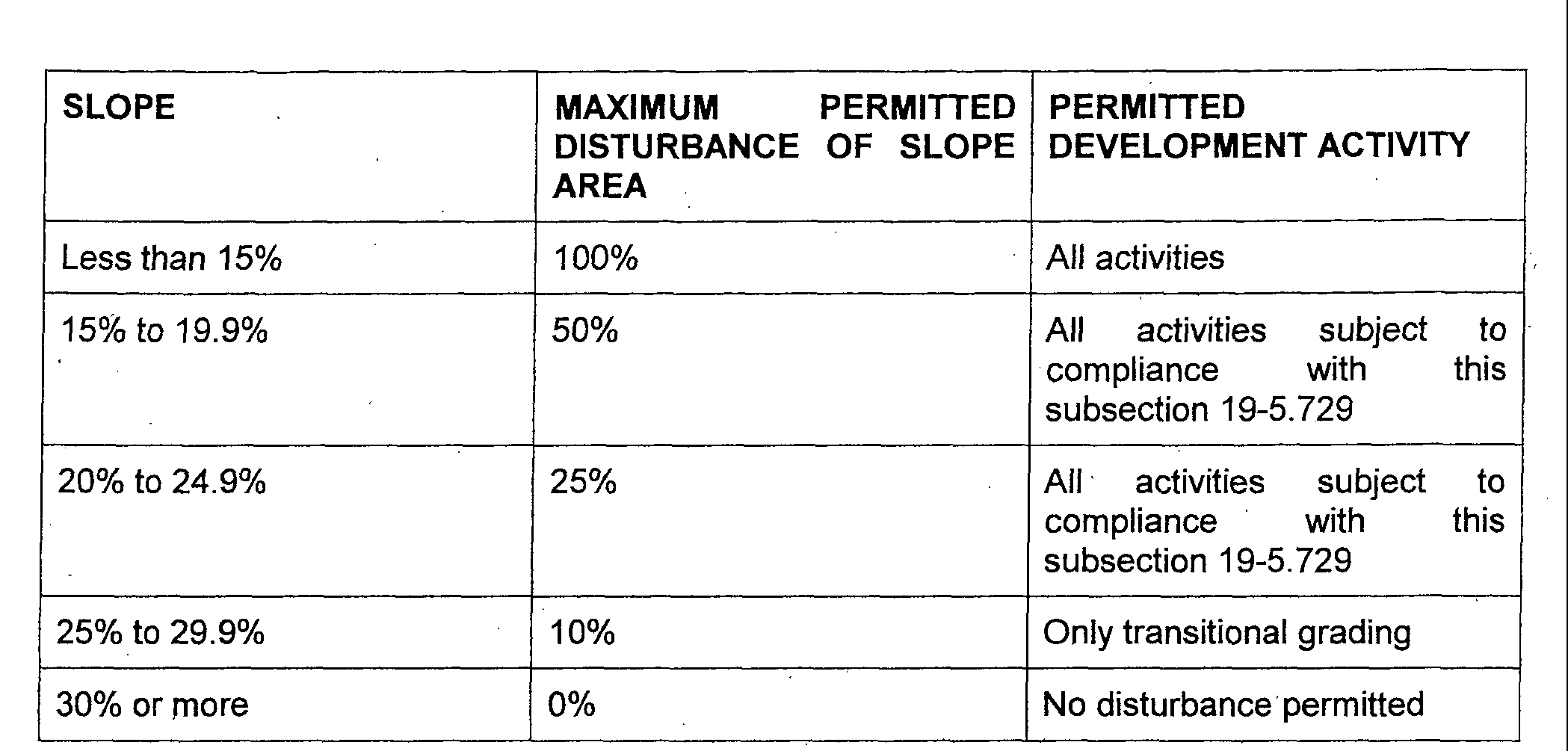
1. Construction control limitations. Disturbance of steep slopes shall be limited to the following based on the indicated slope classifications:
2. No soil shall be excavated, removed, deposited or disturbed within an area of steep or excessive slopes except as a result of and in accordance with the terms of this subsection 19-5.729.
3. Proposed disturbances of soil shall be for purposes consistent with the intent of this subsection and it shall be controlled in a manner that will not cause excessive erosion or other unstable conditions.
4. Provision shall be made for the proper disposition of surface water runoff, both during and post construction, so that it will not create unstable conditions. Appropriate storm drainage facilities shall be constructed as deemed necessary and adequate protective measures shall be provided for downstream properties.
5. Provision shall be made for any structures or protective measures that proposed slopes may require for, the protection of the public safety including but not limited to retaining walls, headwalls and fences.
6. Proper facilities have been or will be provided for a safe water supply and for the disposal of sanitary sewage as approved by the Health Officer.
7. Any proposed building or structure or attendant protective measures will not impede the flow of surface waters through any water course.
8. Any proposed building or structure shall be of sound engineering design with footings designed to extend to stable soil arid/or rock with proper lateral support and that when built may be occupied without peril to the health or safety of the occupants as approved by the Construction Official.
9. Any proposed vehicular facilities including roads, driveways or parking areas shall be so designed that any land disturbances shall not cause excessive erosion. Both the vertical and horizontal alignment of vehicular facilities shall be so designed that hazardous circulation conditions will not be created.
10. All structures shall be constructed in all instances on slopes that do not exceed twenty-five (25%) percent.
11. All public and private streets and roadways shall follow, to the extent possible, the existing natural terrain and slope. Such improvements shall be constructed in all instances on slopes that do not exceed twenty-five (25%) percent.
12. Except for minor topographic variations, driveway grades and the soil cuts/fills in areas of steep slopes are critical concerns of this subsection and shall not be constructed unless the Township Engineer or the Planning Board, as the case may be, is assured that the design achieves the highest standards established by this subsection. The connection of any driveway to a street shall be by a vertical curve of sufficient radius to provide a smooth transition. Said vertical curve and driveway profile shall be designed to accommodate the Master Plan road width. The maximum allowable grade for driveways is fifteen (15%) percent. A maximum grade of 2% shall be required for the first twenty (20) feet of driveway, measured from the curb-line. The horizontal angle of intersection of a driveway with a street shall not be less than sixty (60) degrees.
13. Any fill placed on the lot shall be properly stabilized and, when found necessary depending upon existing slopes and soil types, supported by retaining walls or other appropriate structures as approved by the Township Engineer and subject to the following development conditions:
(a) No retaining wall higher than three (3) feet shall be erected within twenty-five (25) feet of the intersection of any two (2) street right-of ways or within 'any sight easement.
(b) The maximum height of any, retaining wall, measured from any point at ground level, shall be six (feet).
(c) For the purpose of applying height limits, multiple, staggered or tiered walls, and/or wall/fence combinations shall be considered single units unless the horizontal distance between the top of any section or tier shall exceed 10'.
(d) All walls greater than 4' in height shall require certification by a professional engineer that the wall was constructed in accordance with approved plans.
14. All cuts/fills shall be supported by retaining walls or other appropriate retaining structures, when, depending upon the nature of the soil characteristics, such structures are found necessary by the Township Engineer in order to prevent erosion and achieve greater soil stabilization.
g Steep and Excessive Slope Area Regulations Take Precedence. In the event of any conflict between any other provision of Chapter 19 and this ordinance, the provisions of this §19-5.729 shall prevail. In the event of any conflict between any provision of this ordinance and any provision of Chapter 17, Soil and Soil Removal of the Code of the Township of Denville, the provisions of Chapter 17 shall prevail.
**Webmasters Note: The previous section has been added as per Ordinance No. 17-05.

