
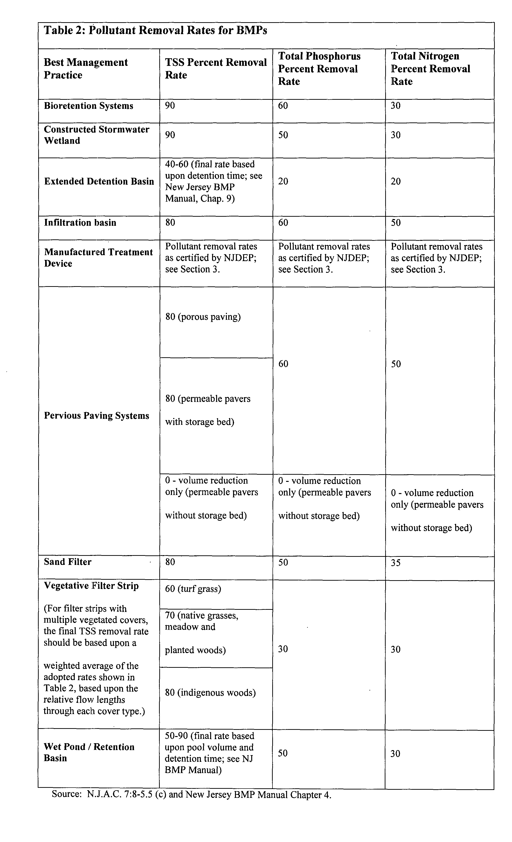
6. Nutrient removal rates for stormwater BMPs. For purposes of post-development nutrient load reduction calculations, Table 2 presents the presumed removal rates for certain BMPs designed in accordance with the New Jersey BMP Manual. If alternative stormwater BMPs are proposed, the applicant shall demonstrate that the selected BMPs will achieve the nutrient removal standard required in Section 4.E.�
C. Methods of Calculating Groundwater Recharge.�
1. In complying with the groundwater recharge requirements in Section 4.C.1.a, the design engineer may calculate groundwater recharge in accordance with the New Jersey Groundwater Recharge Spreadsheet (NJGRS) computer program incorporated herein by reference as amended and supplemented. Information regarding the methodology is available in Section 11.A or from the New Jersey BMP Manual.�
2. Alternative groundwater recharge calculation methods to meet these requirements may be used upon approval by the municipal engineer.�
3. In complying with the groundwater recharge requirements in Section 4.C.1.b, the design engineer shall: �
a) Calculate stormwater runoff volumes in accordance with the USDA Natural Resources Conservation Service (NRCS) methodology, including the NRCS Runoff Equation and Runoff Curve Numbers, as described in the NRCS National Engineering Handbook Part 630 Hydrology and Technical Release 55 Urban Hydrology for Small Watersheds as amended and supplemented; and �
b) Use appropriate 2-year, 24-hour rainfall depths as developed for the project site by the National Oceanic and Atmospheric Administration, available online at http://hdsc.nws.noaa.gov/hdsc/pfds/index.html.�
4. When calculating groundwater recharge or stormwater runoff for pre-developed site conditions, the design engineer shall use the following criteria: �
a)When selecting land covers or calculating Runoff Curve Numbers (CNs) for pre-developed project site conditions, the project site's land cover shall be assumed to be woods. However, another land cover may be used to calculate runoff coefficients if:�
i. Such land cover has existed at the site or portion thereof without interruption for at least five (5) years immediately prior to the time of application; and �
ii. The design engineer can document the character and extent of such land cover through the use of photographs, affidavits, and/or other acceptable land use records. �
b) If more than one land cover, other than woods, has existed on the site during the five (5) years immediately prior to the time of application, the land cover with the lowest runoff potential (including woods) shall be used for the computations. �
c) All pre-developed land covers shall be assumed to be in good hydrologic condition and, if cultivated, shall be assumed to have conservation treatment.�
SECTION 4: STORMWATER MANAGEMENT PERFORMANCE STANDARDS FOR MAJOR DEVELOPMENT.�
A. Nonstructural Stormwater Management Strategies.�
1. To the maximum extent practicable, the performance standards in Section 4 for major development shall be met by incorporating the nine (9) nonstructural strategies identified in Subchapter 5 of the NJ Stormwater Management Rules (N.J.A.C. 7:8-5), and set forth in Section 2.C.4.a, into the design. The applicant shall identify within the Land Use Planning and Source Control Plan required by Section 2.C.4 of this ordinance how each of the nine (9) nonstructural measures will be incorporated into the design of the project to the maximum extent practicable.�
2. If the applicant contends that it is not practical for engineering, environmental or safety reasons to incorporate any of the nine (9) nonstructural strategies into the design of a particular project, the applicant shall provide a detailed rationale establishing a basis for the contention that use of the strategy is not practical on the site. This rationale shall be submitted in accordance with the Checklist Requirements established by Section 2 to Pemberton Township. A Determination by Pemberton Township that this rationale is inadequate or without merit shall result in a denial of the application unless the following conditions are met: �
a) The Land Use Planning and Source Control Plan is amended to include a description of how all nine (9) nonstructural measures will be implemented on the development site, and the amended Plan is approved by Pemberton Township; �
b) The Land Use Planning and Source Control Plan is amended to provide an alternative nonstructural strategy or measure that is not included in the list of nine (9) nonstructural measures, but still meets the performance standards in Section 4, and the amended Plan is approved by Pemberton Township; or �
c) The Land Use Planning and Source Control Plan is amended to provide an adequate rationale for the contention that use of the particular strategy is not practical on the site, and the amended Plan is approved by Pemberton Township.�
3. Existing trees and vegetation to be preserved shall be protected during construction activities in accordance with the "Standard for Tree Protection During Construction" provided in the NJ State Soil Conservation Committee Standards for Soil Erosion and Sediment Control in New Jersey, which is incorporated herein by reference as amended and supplemented.�
4. In addition to all other requirements of this section, each application for major development, and any other application where Pemberton Township otherwise requires a landscaping plan, shall contain a landscaping or revegetation plan in accordance with the Pinelands CMP standards at N.J.A.C. 7:50-6.24(c).�
5. Any land area used as a nonstructural stormwater management measure to meet the performance standards in Section 4 shall be dedicated to a government entity; shall be subjected to a conservation easement filed with the appropriate County Clerk's office; or shall be subjected to an equivalent form of restriction approved by Pemberton Township that ensures that that measure, or equivalent stormwater management measure is maintained in perpetuity, as detailed in Section 6 of this ordinance.�
6. Guidance for nonstructural stormwater management strategies is available in the New Jersey BMP Manual, which may be obtained from the address identified in Section 12.A or found on the NJDEP's website at www.njstormwater.org.�
7. Exception for major development sites. The use of nonstructural strategies to meet the performance standards in Section 4 of this ordinance is not required for major development creating less than one (1) acre of disturbance or for major development creating less than one quarter (1/4) acre of impervious surface. However, the following requirements shall be met: �
a) Each application for major development and any other application where Pemberton Township otherwise requires a landscaping plan shall contain a landscaping or revegetation plan prepared in accordance with the Pinelands CMP standards (N.J.A.C. 7:50-6.24(c)); �
b) Existing trees and vegetation to be preserved shall be protected during construction activities in accordance with the "Standard for Tree Protection During Construction" provided in the NJ State Soil Conservation Committee Standards for Soil Erosion and Sediment Control in New Jersey, which is incorporated herein by reference as amended and supplemented.�
B. Stormwater Runoff Quantity and Rate Standards.�
1. There shall be no direct discharge of stormwater runoff from any point or nonpoint source to any wetland, wetlands transition area or surface waterbody. In addition, stormwater runoff shall not be directed in such a way as to increase the volume and/or rate of discharge into any surface water body from that which existed prior to development of the site.�
2. To the maximum extent practical, there shall be no direct discharge of stormwater runoff onto farm fields so as to protect farm crops from damage due to flooding, 'erosion and long term saturation of cultivated crops and cropland.�
3. For all major developments, the total runoff volume generated from the net increase in impervious surfaces by a ten (10) year, twenty-four (24) hour storm shall be retained and infiltrated onsite.�
4. In addition, the design engineer shall, using the assumptions and factors for stormwater runoff and groundwater recharge calculations contained in Section 3, complete one of the following: �
a) Demonstrate through hydrologic and hydraulic analysis that for stormwater leaving the site, the post-developed stormwater runoff hydrographs from the project site for the 2, 10, and 100-Year storm events do not exceed, at any point in time, the site's pre-developed runoff hydrographs for the same storm events; �
b) Demonstrate through hydrologic and hydraulic analysis that there is no increase, as compared to the pre-construction condition, in the peak runoff rates of stormwater leaving the site for the two, 10 and 100-year storm events and that the increased volume or change in timing of stormwater runoff will not increase flood damage at or downstream of the site. This analysis shall include the analysis of impacts of existing land uses and projected land uses assuming full development under existing zoning and land use ordinances in the drainage area; �
c) Design stormwater management measures so that the peak post-developed stormwater runoff rates from the project site for the two (2), ten (10) and one hundred (100) year storms are fifty, seventy-five and eighty percent (50%, 75% and 80%), respectively, of the site's peak pre-developed stormwater runoff rates for the same storms. Peak outflow rates from onsite stormwater measures for these storms shall be adjusted where necessary to account for the discharge of increased stormwater runoff rates from project site areas not controlled by the onsite measures. These percentages do not have to be applied to those portions of the project site that are not proposed for development at the time of application, provided that such areas are:�
i. Protected from future development by imposition of a conservation easement, deed restriction, or other acceptable legal measures; or �
ii. Would be subject to review under these standards if they were proposed for any degree of development in the future.�
5. In tidal flood hazard areas, a stormwater runoff quantity analysis in accordance with a, b, and c above shall only be applied if the increased volume of stormwater runoff could increase flood damages below the point of discharge.�
6. The standards for stormwater runoff quantity and rate required by this section shall be met using the methods, calculations and assumptions provided in Section 3.�
7. Exceptions �
a) The provisions of Section 4.B.3 shall not apply to major developments that create less than one acre of disturbance or major developments that create less than one-quarter acre of impervious surface.�
C. Groundwater Recharge Standards.�
1. For all major developments, with the exception of those described in Section 4.C.4, below, the design engineer, using the assumptions and factors for stormwater runoff and groundwater recharge calculations contained in Section 3, shall either: �
a) Demonstrate through hydrologic and hydraulic analysis that the postdeveloped project site maintains 100 percent of the site's pre-developed average annual groundwater recharge volume; or �
b) Demonstrate through hydrologic and hydraulic analysis that any increase in the project site's stormwater runoff volume for the two (2) year, twenty four (24) hour storm from pre-developed to post-developed conditions is infiltrated on-site.�
2. The design engineer shall assess the hydraulic impact on the groundwater table and design the project site and all site groundwater recharge measures so as to avoid adverse hydraulic impacts. Adverse hydraulic impacts include, but are not limited to: raising the groundwater table so as to cause surface ponding; flooding of basements and other subsurface structures and areas; preventing a stormwater infiltration basin from completely draining via infiltration within seventy-two (72) hours of a design storm event; and interference with the proper operation of subsurface sewage disposal systems and other surface and subsurface facilities in the vicinity of the groundwater recharge measure.�
3. The standards for groundwater recharge required by this section shall be met using the methods, calculations and assumptions provided in Section 3.�
4. Exceptions. �
a) The preceding groundwater recharge standards shall not apply to major developments that create less than one (1) acre of disturbance or major developments that create less than one quarter (0.25) acre of impervious surface.�
D. Erosion Control Standards. The minimum design and performance standards for erosion control are those established under the Soil Erosion and Sediment Control Act, N.J.S.A. 4:24-39 et seq., and its implementing regulations, N.J.A.C 2:90-1.1 through 1.4.�
E. Stormwater Runoff Quality Standards.�
1. There shall be no direct discharge of stormwater runoff from any point or nonpoint source to any wetland, wetland transition area or surface waterbody.�
2. Stormwater management measures shall be designed to reduce the total suspended solids (TSS) load in the stormwater runoff from the post-developed site by eighty percent (80%) expressed as an annual average.�
3. Stormwater management measures shall also be designed to reduce the nutrient load in the stormwater runoff from the post-developed site by the maximum extent practicable. In achieving this reduction, the design of the development site shall include nonstructural and structural stormwater management measures that optimize nutrient removal while still achieving the groundwater recharge, runoff quantity and rate, and TSS removal standards in this section.�
4. The standards for stormwater runoff quality required by this section shall be met using the methods, calculations, assumptions and pollutant removal rates provided in Section 3.�
5. Exceptions. �
a) The preceding stormwater runoff quality standards shall not apply to major development sites where less than one-quarter (0.25) acre of additional impervious surface is proposed. �
b) The TSS reduction requirement in Section 4.F.2 shall not apply to any stormwater runoff in a discharge regulated under a numeric effluent limitation for TSS imposed under the NJPDES rules (N.J.A.C. 7:14A) or in a discharge specifically exempt under a NJPDES permit from this requirement.�
F. Additional stormwater quality standards for high pollutant loading areas and areas where stormwater runoff is exposed to source material.�
1. This subsection applies to the following areas of a major development as defined in Section 7 of this ordinance: �
a) High pollutant loading areas (HPLAs); and �
b) Areas where stormwater is exposed to "source material."�
2. For a major development in areas described in 1.a or 1.b above, in addition to the infiltration requirements specified in Section 4.B.2 and the groundwater recharge requirements specified in Section 4.C, the applicant shall demonstrate in the Land Use Planning and Source Control Plan required in Section 2.C.4 that the following requirements have been met: �
a) The extent of the areas described in 1.a. and 1.b. above have been minimized on the development site to the maximum extent practicable; �
b) The stormwater runoff from the areas described in 1.a and 1.b above is segregated to the maximum extent practicable from the stormwater runoff generated from the remainder of the site such that co-mingling of the stormwater runoff from the areas described in 1.a and 1.b above and the remainder of the site will be minimized; �
c) The amount of precipitation falling directly on the areas described in 1.a and 1.b above is minimized to the maximum extent practicable by means of a canopy, roof or other similar structure that reduces the generation of stormwater runoff; and �
d) The stormwater runoff from or co-mingled with the areas described in 1.a and 1.b above for the Water Quality Design Storm, defined in Section 3.B. Table 1 shall be subject to pretreatment by one or more of the following stormwater BMPs, designed in accordance with the New Jersey BMP Manual to provide 90 % TSS removal:�
i. Bioretention system; �
ii. Sand filter; �
iii. Wet ponds which shall be hydraulically disconnected by a minimum of 2 feet of vertical separation from the seasonal high water table and shall be designed to achieve a minimum 80% TSS removal rate. �
iv. Constructed stormwater wetlands; and/or�
v. Media filtration system manufactured treatment device with a minimum 80% TSS removal as verified by the New Jersey Corporation for Advanced Technology and as certified by NJDEP.�
e) If the potential for contamination of stormwater runoff by petroleum products exists onsite, prior to being conveyed to the pretreatment BMP required in Section 4.F.2.d above, the stormwater runoff from the areas described in 1.a and 1.b above shall be conveyed through an oil/grease separator or other equivalent manufactured filtering device to remove the petroleum hydrocarbons. The applicant shall provide the reviewing agency with sufficient data to demonstrate acceptable performance of the device.�
G. Threatened and Endangered Species and Associated Habitat Standards. Stormwater management measures shall address the impacts of the development on habitat for threatened and endangered species, in accordance with N.J.A.C. 7:8-5.2(c), N.J.A.C. 7:50-6.27, and 7:50-6.33 and 34.�
H. Exceptions and Mitigation Requirements. �
1. Exceptions from strict compliance from the groundwater recharge, stormwater runoff quantity, and stormwater runoff quality requirements established by this ordinance may be granted, at the discretion of the Pemberton Township, and subject to approval by the Pinelands Commission, provided that all of the following conditions are met: �
a) The exception is consistent with that allowed by Pemberton Township; �
b) Pemberton Township has an adopted and effective municipal stormwater management plan in accordance with N.J.A.C. 7:8-4.4, which includes a mitigation plan in accordance with N.J.A.C. 7:8-4.2(c)11, and is also certified by the Pinelands Commission. The mitigation plan shall identify what measures are necessary to offset the deficit created by granting the exception and the municipality shall submit a written report to the county review agency and the NJDEP describing the exception and the required mitigation. Guidance for developing municipal stormwater management plans, including mitigation plans, is available from the NJDEP, Division of Watershed Management and the New Jersey BMP Manual. �
c)The applicant demonstrates that mitigation, in addition to the requirements of mitigation plan discussed in b) above, will be provided consistent with one of the following options:�
i. Mitigation may be provided off-site, but within the Pinelands Area and within the same drainage area as the development site, and shall meet or exceed the equivalent recharge, quality or quantity performance standard which is lacking on the development site due to the exception; or �
ii. In lieu of the required mitigation, a monetary "in lieu contribution" may be provided by the applicant to Pemberton Township in accordance with the following:�
(a) The amount of the in lieu contribution shall be determined by Pemberton Township, but the maximum in lieu contribution required shall be equivalent to the cost of implementing and maintaining the stormwater management measure(s) for which the exception is granted;�
(b) The in lieu contribution shall be used to fund an off-site stormwater control mitigation project(s) located within the Pinelands Area, within the same drainage area as the development site, and shall meet or exceed the equivalent recharge, quality or quantity performance standards which is lacking on the development site. Such mitigation project shall be identified by Pemberton Township in Pemberton Township's adopted municipal stormwater management plan. The stormwater control project to which the monetary contribution will be applied shall be identified by Pemberton Township at the time the exception is granted. The applicant shall amend the project description and site plan required in Section 2.C.3 to incorporate a description of both the standards for which an on-site exception is being granted and of the selected off-site mitigation project.�
(c) Pemberton Township shall expend the in lieu contribution to implement the selected off-site mitigation project within five (5) years from the date that payment is received. Should Pemberton Township fail to expend the in lieu contribution within the required timeframe, the mitigation option provided in Section 4.H.1.c.iii of this ordinance shall be void and Pemberton Township shall be prohibited from collecting in lieu contributions.�
2. An exception from strict compliance granted in accordance with Hi above shall not constitute a waiver of strict compliance from the requirements of the Pinelands Comprehensive Management Plan at N.J.A.C. 7:50. An applicant should contact the Pinelands Commission to determine whether a waiver of strict compliance is also required in accordance with N.J.A.C. 7:50, Subchapter 4, Part V.�
SECTION 5: DESIGN, CONSTRUCTION, AND SAFETY STANDARDS FOR STRUCTURAL STORMWATER MANAGEMENT MEASURES�
A. General Design and Construction Standards�
1. Structural stormwater management measures shall be designed to meet the standards established in this section. These standards have been developed to protect public safety, conserve natural features, create an aesthetically pleasing site and promote proper onsite stormwater management.�
2. The following structural stormwater management measures may be utilized as part of a stormwater management system at a major land development in the Pinelands, provided that the applicant demonstrates that they are designed, constructed and maintained so as to meet the standards and requirements established by this ordinance. If alternative stormwater management measures are proposed, the applicant shall demonstrate that the selected measures will achieve the standards established by this ordinance. �
a) Bioretention systems; �
b) Constructed stormwater wetlands; �
c) Extended detention basins; �
d) Infiltration basins; �
e) Vegetated filter strips; �
f) Infiltration basins and trenches; �
g) Wet ponds with suitable liners; �
h) Pervious paving systems; and �
i) Manufactured treatment devices, provided their pollutant removal rates are verified by the New Jersey Corporation for Advanced Technology and certified by the NJDEP.�
3. Structural stormwater management measures shall be designed to take into account the existing site conditions, including environmentally critical areas, wetlands, flood-prone areas, slopes, depth to seasonal high water table, soil type, permeability and texture, and drainage area and drainage patterns.�
4. Structural stormwater management measures shall be designed and constructed to be strong, durable, and corrosion resistant (measures that are consistent with the relevant portions of the Residential Site Improvement Standards at N.J.A.C. 5:21- 7.3, 7.4, and 7.8 shall be deemed to meet this requirement); to minimize and facilitate maintenance and repairs; and to ensure proper functioning.�
5. For all stormwater management measures at a development site, each applicant shall submit a detailed Inspection, Maintenance and Repair Plan consistent with the requirements of Section 6 of this ordinance.�
6. To the maximum extent practicable, the design engineer shall design structural stormwater management measures on the development site in a manner that: �
a) Limits site disturbance, maximizes stormwater management efficiencies, and maintains or improves aesthetic conditions; �
b) Utilizes multiple stormwater management measures, smaller in size and distributed spatially throughout the land development site, instead of a single larger structural stormwater management measure; �
c) Incorporates pretreatment measures. Pretreatment can extend the functional life and increase the pollutant removal capability of a structural stormwater management measure. Pretreatment measures may be designed in accordance with the New Jersey BMP Manual or other sources approved by the municipal engineer.�
7. Stormwater management basins shall be designed in a manner that complements and mimics the existing natural landscape, including but not limited to the following design strategies: �
a) Use of natural, non-wetland wooded depressions for stormwater runoff storage; and �
b) Establishment of attractive landscaping in and around the basin that mimics the existing vegetation and incorporates native Pinelands plants, including, but not limited to, the species listed in N.J.A.C. 7:50-6.25 and 6.26.�
8. Stormwater management basins shall be designed with gently sloping sides. The maximum allowable basin side slope shall be three (3) horizontal to one (1) vertical (3:1).�
9. Guidance on the design and construction of structural stormwater management measures may be found in the New Jersey BMP Manual. Other guidance sources may also be used upon approval by the municipal engineer.�
10. After all construction activities and required field testing have been completed on the development site, as-built plans depicting design and as-built elevations of all stormwater management measures shall be prepared by a Licensed Land Surveyor and submitted to the municipal engineer. Based upon the municipal engineer's review of the as-built plans, all corrections or remedial actions deemed by the municipal engineer to be necessary due to the failure to comply with the standards established by this ordinance and/or any reasons of public health or safety shall be completed by the applicant.�
B. Design and Construction Standards for Stormwater Infiltration BMPs.�
1. Stormwater infiltration BMPs, such as bioretention systems with infiltration, dry wells, infiltration basins, pervious paving systems with storage beds, and sand filters with infiltration, shall be designed, constructed and maintained to completely drain the total runoff volume generated by the basin's maximum design storm within seventy-two (72) hours after a storm event. Runoff storage for greater times can render the BMP ineffective and may result in anaerobic conditions, odor and both water quality and mosquito breeding problems.�
2. Stormwater infiltration BMPs shall be designed, constructed and maintained to provide a minimum separation of at least two (2) feet between the elevation of the lowest point of the bottom of the infiltration BMP and the seasonal high water table.�
3. A stormwater infiltration BMP shall be sited in suitable soils verified by fieldtesting to have permeability rates between one (1) and twenty (20) inches per hour. If such site soils do not exist or if the design engineer demonstrates that it is not practical for engineering, environmental or safety reasons to site the stormwater infiltration BMP(s) in such soils, then the stormwater infiltration BMP(s) may be sited in soils verified by field testing to have permeability rates in excess of twenty (20) inches per hour, provided that a bioretention system, designed, installed and maintained in accordance with the New Jersey BMP Manual, is installed to meet one of the following conditions: �
a) The bioretention system is constructed as a separate measure designed to provide pretreatment of stormwater and to convey the pretreated stormwater into the infiltration BMP; or �
b) The bioretention system is integrated into and made part of the infiltration BMP and, as such, does not require an underdrain system. If this option is selected, the infiltration BMP shall be designed and constructed so that the maximum water depth in the bioretention system portion of the BMP during treatment of the stormwater quality design storm is twelve (12) inches in accordance with the New Jersey BMP Manual.�
4. The minimum design permeability rate for the soil within a BMP that relies on infiltration shall be one-half (0.5) inch per hour. A factor of safety of two (2) shall be applied to the soil's field-tested permeability rate to determine the soil's design permeability rate. For example, if the field-tested permeability rate of the soil were four (4) inches per hour, its design permeability rate would be two (2) inches per hour). The minimum design permeability rate for the soil within a stormwater infiltration basin shall also be sufficient to achieve the minimum seventy-two (72) hour drain time described in 1. above. The maximum design permeability shall be ten (10) inches per hour.�
5. A soil's field tested permeability rate shall be determined in accordance with the following: �
a) The pre-development field test permeability rate shall be determined according to the methodologies provided in Section 11.C.3 of this ordinance; �
b) The results of the required field permeability tests shall demonstrate a minimum tested infiltration rate of one (1) inch per hour; �
c)After all construction activities have been completed on the site and the finished grade has been established in the infiltration BMP, post-development field permeability tests shall also be conducted according to the methodologies provided in Section 11.C.3 of this ordinance; �
d) If the results of the post-development field permeability tests fail to achieve the minimum required design permeability rates in 5 above utilizing a factor of safety of two (2), the stormwater infiltration BMP shall be renovated and re-tested until such minimum required design permeability rates are achieved; and �
e) The results of all field permeability tests shall be certified by a Professional Engineer and transmitted to the municipal engineer.�
6. To help ensure maintenance of the design permeability rate over time, a six (6) inch layer of K5 soil shall be placed on the bottom of a stormwater infiltration BMP. This soil layer shall meet the textural and permeability specifications of a K5 soil as provided at N.J.A.C. 7:9A, Appendix A, Figure 6, and be certified to meet these specifications by a Professional Engineer licensed in the State of New Jersey. The depth to the seasonal high water table shall be measured from the bottom of the K5 sand layer.�
7. The design engineer shall assess the hydraulic impact on the groundwater table and design the project site and all stormwater infiltration basins so as to avoid adverse hydraulic impacts. Adverse hydraulic impacts include, but are not limited to: raising the groundwater table so as to cause surface ponding; flooding of basements and other subsurface structures and areas; preventing a stormwater infiltration basin from completely draining via infiltration within seventy-two (72) hours of a design storm event; and interference with the proper operation of subsurface sewage disposal systems and other surface and subsurface structures in the vicinity of the stormwater infiltration basin.�
8. The design engineer shall conduct a groundwater mounding analysis, as defined in Section 7, of all stormwater infiltration BMPs. The mounding analysis shall be conducted in accordance with the requirements in Section 11.C.3.1. Where the mounding analysis identifies adverse impacts, the stormwater infiltration BMP shall be redesigned or relocated as appropriate.�
9. Stormwater infiltration BMPs shall be constructed in accordance with the following: �
a) To avoid sedimentation that may result in clogging and reduce the basin's permeability rate, stormwater infiltration basins shall be constructed according to the following:�
i. Unless the conditions in (ii) below are met, a stormwater infiltration basin shall not be placed into operation until its drainage area is completely stabilized. Instead, upstream runoff shall be diverted around the basin and into separate, temporary stormwater management facilities and sediment basins. Such temporary facilities and basins shall be installed and utilized for stormwater management and sediment control until stabilization is achieved in accordance with the Standards for Soil Erosion and Sediment Control in New Jersey, which is incorporated herein by reference as amended and supplemented. �
ii. If the design engineer determines that, for engineering, environmental or safety reasons, temporary stormwater management facilities and sediment basins cannot be constructed on the site, the stormwater infiltration basin may be placed into operation prior to the complete stabilization of its drainage area provided that the basin's bottom during this period is constructed at a depth at least two (2) feet higher than its final design elevation. All other infiltration BMP construction requirements in this section shall be followed. When the drainage area is completely stabilized, all accumulated sediment shall be removed from the infiltration BMP, which shall then be excavated to its final design elevation in accordance with the construction requirements of this section and the performance standards in Section 4. �
b) To avoid compaction of subgrade soils of BMPs that rely on infiltration, no heavy equipment such as backhoes, dump trucks or bulldozers shall be permitted to operate within the footprint of the BMP. All excavation required to construct a stormwater infiltration BMP shall be performed by equipment placed outside the BMP. If this is not possible, the soils within the excavated area shall be renovated and tilled after construction is completed to reverse the effects of compaction. In addition, post-development soil permeability testing shall be performed in accordance with B.5 of this section. �
c) Earthwork associated with stormwater infiltration BMP construction, including excavation, grading, cutting or filling, shall not be performed when soil moisture content is above the lower plastic limit.�
C. Safety Standards for Structural Stormwater Management Measures �
1. If a structural stormwater management measure has an outlet structure, escape provisions shall be incorporated in or on the structure. Escape provisions means the permanent installation of ladders, steps, rungs, or other features that provide readily accessible means of ingress and egress from the outlet structure.�
2. A trash rack is a device intended to intercept runoff-borne trash and debris that might otherwise block the hydraulic openings in an outlet structure of a structural stormwater management measure. Trash racks shall be installed upstream of such outlet structure openings as necessary to ensure proper functioning of the structural stormwater management measure in accordance with the following: a) The trash rack should be constructed primarily of bars aligned in the direction of flow with one (1) inch spacing between the bars to the elevation of the water quality design storm. For elevations higher than the water quality design storm, the bars shall be spaced no greater than one-third (1/3) the width of the hydraulic opening it is protecting or six inches, whichever is less. Transverse bars aligned perpendicular to flow should be sized and spaced as necessary for rack stability and strength. b) The trash rack shall not adversely affect the hydraulic performance of either the outlet structure opening it is protecting or the overall outlet structure. c) The trash rack shall have sufficient net open area under clean conditions to limit the peak design storm velocity through it to a maximum of 2.5 feet per second. d) The trash rack shall be constructed and installed to be rigid, durable, and corrosion resistant, and shall be designed to withstand a perpendicular live loading of 300 pounds per square foot.�
3. An overflow grate is a device intended to protect the opening in the top of a stormwater management measure outlet structure. If an outlet structure has an overflow grate, such grate shall meet the following requirements: �
a) The overflow grate shall be secured to the outlet structure but removable for emergencies and maintenance; �
b) The overflow grate spacing shall be no more than two (2) inches across the smallest dimension; and �
c)The overflow grate shall be constructed and installed to be rigid, durable, and corrosion resistant, and shall be designed to withstand a perpendicular live loading of three hundred (300) pounds per square foot.�
4. The maximum side slope for an earthen dam, embankment, or berm shall not be steeper than three (3) horizontal to one (1) vertical (3:1).�
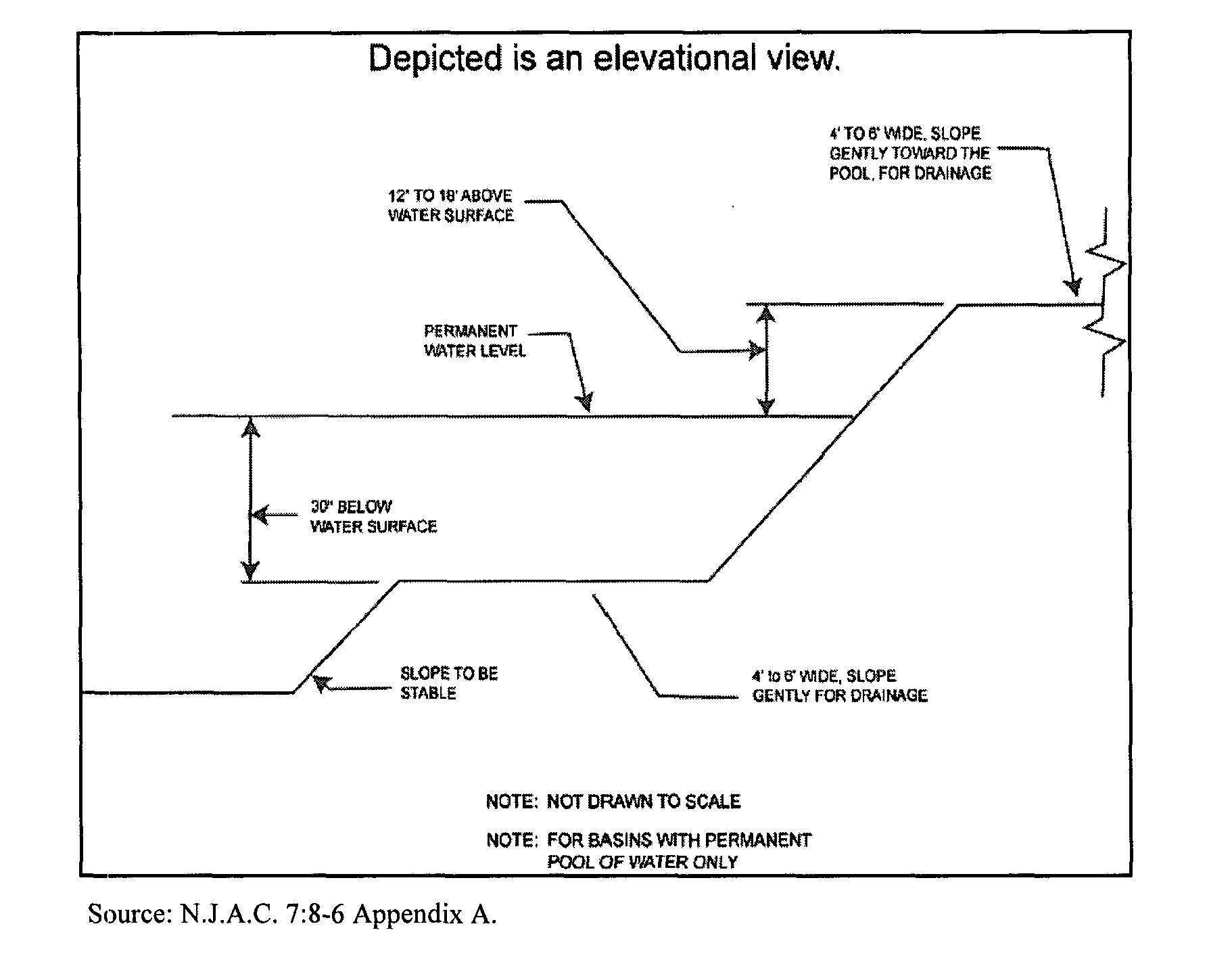
5. Safety ledges shall be constructed on the slopes of all new structural stormwater management measures having a permanent pool of water deeper than two and one-half feet. Such safety ledges shall be comprised of two steps. Each step shall be four (4) to six (6) feet in width. One step shall be located approximately two and one-half (21/2) feet below the permanent water surface, and the second step shall be located one (1) to one and one-half (11/2) feet above the permanent water surface. See a) below, for an illustration of safety ledges in a stormwater management basin. �
a) Illustration of safety ledges.�
SECTION 6: INSPECTION, MAINTENANCE AND REPAIR OF STORMWATER MANAGEMENT MEASURES.�
A. Applicability. Projects subject to review pursuant to Section 1.0 of this ordinance shall comply with the requirements of Sections 6.B and 6.0 below.�
B. General Inspection, Maintenance and Repair Plan.�
1. The design engineer shall prepare an Inspection, Maintenance and Repair Plan for the stormwater management measures, including both structural and nonstructural measures incorporated into the design of a major development. This plan shall be submitted as part of the Checklist Requirements established in Section 2.C. Inspection and maintenance guidelines for stormwater management measures are available in the New Jersey BMP Manual.�
2. The Inspection, Maintenance and Repair Plan shall contain the following: �
a) Accurate and comprehensive drawings of the site's stormwater management measures; �
b) Specific locations of each stormwater management measure identified by means of longitude and latitude as well as block and lot number; �
c) Specific preventative and corrective maintenance tasks and schedules for such tasks for each stormwater BMP; �
d) Cost estimates, including estimated cost of sediment, debris or trash removal; and �
e) The name, address and telephone number of the person or persons responsible for regular inspections and preventative and corrective maintenance (including repair and replacement). If the responsible person or persons is a corporation, company, partnership, firm, association, municipality or political subdivision of this State, the name and telephone number of an appropriate contact person shall also be included.�
3. The person responsible for inspection, maintenance and repair identified under Section 6.B.2 above shall maintain a detailed log of all preventative and corrective maintenance performed for the site's stormwater management measures, including a record of all inspections and copies of all maintenance-related work orders in the Inspection, Maintenance and Repair Plan. Said records and inspection reports shall be retained for a minimum of five (5) years.�
4. If the Inspection, Maintenance and Repair Plan identifies a person other than the developer (for example, a public agency or homeowners' association) as having the responsibility for inspection and maintenance, the plan shall include documentation of such person's agreement to assume this responsibility, or of the developer's obligation to dedicate a stormwater management measure to such person under an applicable ordinance or regulation.�
5. If the person responsible for inspection, maintenance and repair identified under Section 6.B.3 above is not a public agency, the maintenance plan and any future revisions based on Section 6.B.6 below shall be recorded upon the deed of record for each property on which the maintenance described in the maintenance plan shall be undertaken.�
6. The person responsible for inspection, maintenance and repair identified under Section 6.B.2 above shall evaluate the effectiveness of the Inspection, Maintenance and Repair Plan at least once per year and update the plan and the deed as needed.�
7. The person responsible for inspection, maintenance and repair identified under Section 6.B.2 above shall submit the updated Inspection, Maintenance and Repair Plan to Pemberton Township when the Inspection, Maintenance and Repair Plan is updated.�
8. The person responsible for inspection, maintenance and repair identified under Section 6.B.2 above shall retain and make available, upon request by any public entity with administrative, health, environmental or safety authority over the site the Inspection, Maintenance and Repair Plan and the documentation required by Sections 6.B.2 and 6.B.3 above.�
C. Responsibility for inspection, repair and maintenance shall not be assigned or transferred to the owner or tenant of an individual property in a residential development or project, unless such owner or tenant owns or leases the entire residential development or project.�
D. Preventative and corrective maintenance shall be performed to maintain the function of the stormwater management measure, including, but not limited to: repairs or replacement to any associated appurtenance of the measure; removal of sediment, debris, or trash; restoration of eroded areas; snow and ice removal; fence repair or replacement; restoration of vegetation; repair or replacement of linings; and restoration of infiltration function.�
E. Storm water management measure easements shall be provided by the property owner as necessary for facility inspections and maintenance and preservation of stormwater runoff conveyance, infiltration, and detention areas and facilities. The purpose of the easement shall be specified in the maintenance agreement.�
F. In the event that the stormwater management measure becomes a public health nuisance or danger to public safety or public health, or if it is in need of maintenance or repair, Pemberton Township shall so notify the responsible person in writing. Upon receipt of that notice, the responsible person shall have fourteen (14) days to effect maintenance and repair of the facility in a manner that is approved by the municipal engineer or the municipal engineer's designee. Pemberton Township, at its discretion, may extend the time allowed for effecting maintenance and repair for good cause. If the responsible person fails or refuses to perform such maintenance and repair within the allowable time, Pemberton Township may immediately proceed to do so with its own forces and equipment and/or through contractors and shall bill the cost thereof to the responsible person.�
G. Requirements for Inspection, Maintenance and Repair of Stormwater BMPs that rely on infiltration. If a stormwater infiltration BMP is incorporated into the design of a major development, the applicant shall include the following requirements in its Inspection, Maintenance and Repair Plan:�
1. Once per month (if needed): Mow side slopes, remove litter and debris, stabilize eroded banks, repair erosion at inflow structure(s);�
2. After every storm exceeding one (1) inch of rainfall: Ensure that infiltration BMPs drain completely within seventy-two (72) hours after the storm event. If stored water fails to infiltrate seventy-two (72) hours after the end of the storm, corrective measures shall be taken. Raking or tilling by light equipment can assist in maintaining infiltration capacity and break up clogged surfaces;�
3. Four times per year (quarterly): Inspect stormwater infiltration BMPs for clogging and excessive debris and sediment accumulation within the BMP, remove sediment (if needed) when completely dry;�
4. Two times per year: Inspect for signs of damage to structures, repair eroded areas, check for signs of petroleum contamination and remediate;�
5. Once per year: Inspect BMPs for unwanted tree growth and remove if necessary, disc or otherwise aerate bottom of infiltration basin to a minimum depth of six (6) inches; and�
6. After every storm exceeding one (1) inch of rainfall, inspect and, if necessary, remove and replace K5 sand layer and accumulated sediment, to restore original infiltration rate.�
7. Additional guidance for the inspection, maintenance and repair of stormwater infiltration BMPs can be found in the New Jersey BMP Manual.�
H. Maintenance Guarantee.�
1. The applicant shall provide a maintenance guarantee in accordance with N.J.S.A. 40:55D-53 to ensure that all stormwater management measures required under the provisions of this ordinance will be maintained in accordance with the specifications established herein.�
2. Additionally, for those stormwater management measures that are to be inspected, maintained and repaired by a public agency, Pemberton Township shall collect an prepaid fee from the applicant in the amount the Township determines is needed to provide long-term inspection, maintenance and repair of all stormwater management measures.�
This prepaid fee shall be placed in a dedicated cash management account and expended by Pemberton Township for the sole purpose of conducting inspection, maintenance and repair activities for all stormwater management measures required under the applicant's major development application approval. The calculation of the fee shall be based upon the Inspection, Maintenance and Repair Plan (Plan) required to be prepared by the applicant and approved by Pemberton Township.�
�
The Plan shall include an estimate of the present value of the cost to inspect, maintain and repair the stormwater management measure(s) in accordance with the Plan for the useful life of those measure(s). Pemberton Township shall furnish the applicant their published hourly rates as prescribed by their salary ordinance for public works' and other personnel having responsibilities associated with stormwater management.�
Added to this fee shall be an amount mutually determined by Pemberton Township and the applicant to account for the reconstruction/reconditioning of stormwater management measures that are based on the reasonable life expectancies of those facilities. After an agreed number of years, depending on the type of measure(s), the measure(s) will need to be reconstructed/reconditioned. The amount shall be based on the future value of the measure(s) being reconstructed/reconditioned.�
Both inflation rates and bank interest rates shall be based on the ten year average published in the Wall Street Journal or other approved publication. Interest accruing in the account must also be accounted for at an agreed upon interest rate, to arrive at an amount. The costs for reconstructing/reconditioning the measure(s) shall be taken from the engineer's probable cost estimate that is utilized to determine the amount of the required performance guarantee. It is acceptable to attach a percentage of failure to certain line items in the estimate.�
3. Additionally, for those stormwater management measures that are to be inspected, maintained and repaired by a homeowners association, condominium association or some other form of non-public ownership, no fee shall be collected by Pemberton Township. Instead, the ownership entity shall establish and maintain a fund for the annual inspection and testing program, annual maintenance and repair program and annual contribution to a contingency fund for long-term reconstruction/reconditioning.�
The initial costs agreed to for the annual inspection and testing program and annual maintenance and repair program shall be based upon actual itemized proposals offered to the applicant by prospective vendors. The annual cost expended on inspection, testing and maintenance shall be reported to Pemberton Township to verify that maintenance is not being deferred and to inform the Township on the magnitude of those services.�
The contingency fund shall require sufficient funds to be committed for long-term reconstruction/reconditioning of the stormwater management measure(s). Major reconstruction/reconditioning activities will necessitate proper financial planning. After an agreed number of years, depending on the type of measure(s), the measure(s) will need to be reconstructed/reconditioned. The contingency fund in the financial schedule shall be based on the future value of the measure being reconstructed/reconditioned.�
Both inflation rates and bank interest rates shall be based on the ten year average published in the Wall Street Journal or other approved publication. Interest accruing in the account must also be accounted for at an agreed upon interest rate, to arrive at an annual contribution amount.�
SECTION 7: DEFINITIONS.�
Unless specifically defined below, words or phrases used in this ordinance shall be interpreted so as to give them the meaning they have in common usage and to give this ordinance its most reasonable application. When used in this ordinance, the following terms shall have the meanings herein ascribed to them.�
PEMBERTON TOWNSHIP means the Planning Board, Zoning Board of Adjustment or other board, agency or official of Pemberton Township with authority to approve or disapprove subdivisions, site plans, construction permits, building permits or other applications for development approval. For the purposes of reviewing development applications and ensuring compliance with the requirements of this ordinance, Pemberton Township may designate the municipal engineer or other qualified designee to act on behalf of Pemberton Township.�
AQUACULTURE means the propagation, rearing and subsequent harvesting of aquatic organisms in controlled or selected environments, and their subsequent processing, packaging and marketing, including but not limited to, activities to intervene in the rearing process to increase production such as stocking, feeding, transplanting and providing for protection from predators.�
CERTIFICATION means either a written statement signed and sealed by a licensed New Jersey Professional Engineer attesting that a BMP design or stormwater management system conforms to or meets a particular set of standards or to action taken by the Commission pursuant to N.J.A.C. 7:5C)-3, Part II or Part IV. Depending upon the context in which the term is use, the terms "certify" and "certified" shall be construed accordingly.�
COMPACTION means the increase in soil bulk density caused by subjecting soil to greater-than- normal loading. Compaction can also decrease soil infiltration and permeability rates.�
CONSTRUCTION means the construction, erection, reconstruction, alteration, conversion, demolition, removal or equipping of buildings, structures or components of a stormwater management system including but not limited to collection inlets, stormwater piping, swales and all other conveyance systems, and stormwater BMPs.�
COUNTY REVIEW AGENCY means an agency designated by the County Board of Chosen Freeholders to review municipal stormwater management plans and implementing ordinance(s). The county review agency may either be:�
A.county planning agency; or�
A.county water resource association created under N.J.S.A. 58:16A-55.5, if the ordinance or resolution delegates authority to approve, conditionally approve, or disapprove municipal stormwater management plans and implementing ordinances.�
DESIGN ENGINEER means a person professionally qualified and duly licensed in New Jersey to perform engineering services that may include, but not necessarily be limited to, development of project requirements, creation and development of project design and preparation of drawings and specifications.�
DESIGN PERMEABILITY means the tested permeability rate with a factor of safety of two (2) applied to it (e.g., if the tested permeability rate of the soils were four (4) inches per hour, the design rate would be two (2) inches per hour).�
DEVELOPMENT means the change of or enlargement of any use or disturbance of any land, the performance of any building or mining operation, the division of land into two or more parcels, and the creation or termination of rights of access or riparian rights including, but not limited to:�
2. A reconstruction, alteration of the size, or material change in the external appearance of a structure or land;�
3.A material increase in the intensity of use of land, such as an increase in the number of businesses, manufacturing establishments, offices or dwelling units in a structure or on land;�
4. Commencement of resource extraction or drilling or excavation on a parcel of land;�
5. Demolition of a structure or removal of trees;�
6. Commencement of forestry activities;�
7. Deposit of refuse, solid or liquid waste or fill on a parcel of land;�
8. In connection with the use of land, the making of any material change in noise levels, thermal conditions, or emissions of waste material; and�
9. Alteration, either physically or chemically, of a shore, bank, or flood plain, seacoast, river, stream, lake, pond, wetlands or artificial body of water.�
In the case of development on agricultural land, i.e. lands used for an agricultural use or purpose as defined at N.J.A.C. 7:50-2.11, development means: any activity that requires a State permit; any activity reviewed by the County Agricultural Boards (CAB) and the State Agricultural Development Committee (SADC), and municipal review of any activity not exempted by the Right to Farm Act, N.J.S.A. 4:1C-1 et seq.�
DEVELOPMENT, MAJOR means any division of land into five or more lots; any construction or expansion of any housing development of five or more dwelling units; any construction or expansion of any commercial or industrial use or structure on a site of more than three acres; or any "development," grading, clearing or disturbance of an area in excess of five thousand square feet (5,000 ft2). Disturbance for the purpose of this ordinance is the placement of impervious surface or exposure and/or movement of soil or bedrock or clearing, cutting or removing of vegetation.�
DEVELOPMENT, MINOR means all development other than major development.�
�
DRAINAGE AREA means a geographic area within which stormwater, sediments, or dissolved materials drain to a BMP, a stormwater management system, a particular receiving waterbody or a particular point along a receiving waterbody.�
ENVIRONMENTALLY CRITICAL AREA means an area or feature which is of significant environmental value, including but not limited to: stream corridors; natural heritage priority sites; habitat of endangered or threatened animal species; threatened or endangered plants of the Pinelands pursuant to N.J.A.C. 7:5-6.27(a); large areas of contiguous open space or upland forest; steep slopes; and well head protection and groundwater recharge areas. T & E habitat constitutes habitat that is critical for the survival of a local population of threatened and endangered species or habitat that is identified using the Department's Landscape Project as approved by the Department's Endangered and Nongame Species Program, whichever is more inclusive. Threatened and endangered wildlife shall be protected in conformance with N.J.A.C. 7:50-6.33.�
EXCEPTION means the approval by the approving authority of a variance or other material departure from strict compliance with any section, part, phrase or provision of this ordinance. An exception may be granted only under certain specific, narrowly defined conditions described herein and does not constitute a waiver of strict compliance with any section, part, phrase or provision of the Pinelands Comprehensive Management Plan (N.J.A.C. 7:50-1.1 et seq.).�
EXTENDED DETENTION BASIN means a facility constructed through filling and/or excavation that provides temporary storage of stormwater runoff. It has an outlet structure that detains and attenuates runoff inflows and promotes the settlement of pollutants. An extended detention basin is normally designed as a multi-stage facility that provides runoff storage and attenuation for both stormwater quality and quantity management. The term "stormwater detention basin" shall have the same meaning as "extended detention basin."�
FINISHED GRADE means the elevation of the surface of the ground after completion of final grading, either via cutting, filling or a combination thereof.�
GRADING means modification of a land slope by cutting and filling with the native soil or re- distribution of the native soil, which is present at the site.�
GROUNDWATER means water below the land surface in a zone of saturation.�
�
GROUNDWATER MOUNDING ANALYSIS means a test performed to demonstrate that the groundwater below a stormwater infiltration basin will not "mound up," encroach on the unsaturated zone, break the surface of the ground at the infiltration area or downslope, and create an overland flow situation.�
HEAVY EQUIPMENT means equipment, machinery, or vehicles that exert ground pressure in excess of eight (8) pounds per square inch.�
HIGH POLLUTANT LOADING AREA means an area in an industrial or commercial development site: where solvents and/or petroleum products are loaded/unloaded, stored, or applied; where pesticides are loaded/unloaded or stored; where hazardous materials are expected to be present in greater than "reportable quantities" as defined by the United States Environmental Protection Agency (EPA) at 40 CFR 302.4; where recharge would be inconsistent with NJDEP-approved remedial action work plan or landfill closure plan; and/or where a high risk exists for spills of toxic materials, such as gas stations and vehicle maintenance facilities. The term "HPLA" shall have the same meaning as "High Pollutant Loading Area."�
IMPERVIOUS SURFACE means a surface that has been covered with a layer of material so that it is highly resistant to infiltration by water.�
INFILTRATION is the process by which precipitation enters the soil through its surface.�
�
IN LIEU CONTRIBUTION means a monetary fee collected by Pemberton Township in lieu of requiring strict on-site compliance with the groundwater recharge, stormwater runoff quantity and/or stormwater runoff quality standards established in this ordinance.�
INSTALL means to assemble, construct, put in place or connect components of a stormwater management system.�
MITIGATION means acts necessary to prevent, limit, remedy or compensate for conditions that may result from those cases where an applicant has demonstrated the inability or impracticality of strict compliance with the stormwater management requirements set forth in N.J.A.C. 7:8, in an adopted regional stormwater management plan, or in a local ordinance which is as protective as N.J.A.C. 7:8, and an exception from strict compliance is granted by Pemberton Township and the Pinelands Commission.�
NEW JERSEY STORMWATER BEST MANAGEMENT PRACTICES MANUAL means guidance developed by the New Jersey Department of Environmental Protection, in coordination with the New Jersey Department of Agriculture, the New Jersey Department of Community Affairs, the New Jersey Department of Transportation, municipal engineers, county engineers, consulting firms, contractors, and environmental organizations to address the standards in the New Jersey Stormwater Management Rules, N.J.A.C. 7:8. The BMP manual provides examples of ways to meet the standards contained in the rule. An applicant may demonstrate that other proposed management practices will also achieve the standards established in the rules. The manual, and notices regarding future versions of the manual, are available from the Division of Watershed Management., NJDEP, PO Box 418, Trenton, New Jersey 08625; and on the NJDEP's website, www.njstormwater.org. The term "New Jersey BMP Manual" shall have the same meaning as "New Jersey Stormwater Best Management Practices Manual."�
NJDEP means the New Jersey Department of Environmental Protection.�
NJPDES means the New Jersey Pollutant Discharge Elimination System as set forth in N.J.S.A. 58:10A-1 et seq. and in N.J.A.C. 7:14A.�
NJPDES PERMIT means a permit issued by the NJDEP pursuant to the authority of the Water Pollution Control Act, N.J.S.A. 58:10A-1 et seq., and N.J.A.C. 7:14A for a discharge of pollutants.�
NONPOINT SOURCE means:�
�
1. Any human-made or human-induced activity, factor, or condition, other than a point source, from which pollutants are or may be discharged;�
2. Any human-made or human-induced activity, factor, or condition, other than a point source, that may temporarily or permanently change any chemical, physical, biological, or radiological characteristic of waters of the State from what was or is the natural, pristine condition of such waters, or that may increase the degree of such change; or�
3. Any activity, factor, or condition, other than a point source, that contributes or may contribute to water pollution.�
The term "NPS" shall have the same meaning as "nonpoint source."�
NONSTRUCTURAL BMP means a stormwater management measure, strategy or combination of strategies that reduces adverse stormwater runoff impacts through sound site planning and design. Nonstructural BMPs include such practices as minimizing site disturbance, preserving important site features, reducing and disconnecting impervious cover, flattening slopes, utilizing native vegetation, minimizing turf grass lawns, maintaining natural drainage features and characteristics and controlling stormwater runoff and pollutants closer to the source. The term "Low Impact. Development technique" shall have the same meaning as "nonstructural BMP."�
NUTRIENT means a chemical element or compound, such as nitrogen or phosphorus, which is essential to and promotes the development of organisms.�
PERMEABILITY means the rate at which water moves through a saturated unit area of soil or rock material at hydraulic gradient of one, determined as prescribed in N.J.A.C. 7:9A-6.2 (Tube Permeameter Test), N.J.A.C. 6.5 (Pit Bailing Test) or N.J.A.C. 6.6 (Piezometer Test). Alternative permeability test procedures may be accepted by the approving authority provided the test procedure attains saturation of surrounding soils, accounts for hydraulic head effects on infiltration rates, provides a permeability rate with units expressed in inches per hour and is accompanied by a published source reference. Examples of suitable sources include hydrogeology, geotechnical, or engineering text and design manuals, proceedings of American Society for Testing and Materials (ASTM) symposia, or peer-review journals. Neither a Soil Permeability Class Rating Test, as described in N.J.A.C. 7:9A-6.3, nor a Percolation Test, as described in N.J.A.C. 7:9A-6.4, are acceptable tests for establishing permeability values for the purpose of complying with this ordinance.�
PERMEABLE means having a permeability of one (1) inch per hour or faster. The terms "permeable soil," "permeable rock" and "permeable fill" shall be construed accordingly.�
PERSON means any individual, corporation, company, partnership, firm, association, municipality or political subdivision of this State subject to municipal jurisdiction pursuant to the Municipal Land Use Law, N.J.S.A. 40:55D-1 et seq.�
PINELANDS COMMISSION or "Commission" means the Commission created pursuant Section 5 of the Pinelands Protection Act, N.J.S.A. 13:18A-5.�
PINELANDS CMP means the New Jersey Pinelands Comprehensive Management Plan (N.J.A.C. 7:50 1.1 et seq.).�
POINT SOURCE means any discernible, confined, and discrete conveyance, including, but not limited to, any pipe, ditch, channel, tunnel, conduit, well, discrete fissure, container, rolling stock, concentrated animal feeding operation, landfill leachate collection system, vessel, or other floating craft, from which pollutants are or may be discharged. This term does not include return flows from irrigated agriculture.�
POLLUTANT means any dredged spoil, solid waste, incinerator residue, filter backwash, sewage, garbage, refuse, oil, grease, sewage sludge, munitions, chemical wastes, biological materials, medical wastes, radioactive substances (except those regulated under the Atomic Energy Act of 1954, as amended (42 U.S.C. 2011 et seq.), thermal waste, wrecked or discarded equipment, rock, sand, suspended solids, cellar dirt, industrial, municipal, agricultural, and construction waste or runoff, or other residue discharged directly or indirectly to the land, groundwaters or surface waters of the State, or to a domestic treatment works. "Pollutant" includes both hazardous and nonhazardous pollutants.�
PROFESSIONAL ENGINEER means a person licensed to practice Professional Engineering in the State of New Jersey pursuant to N.J.S.A. 48:8-27 et seq.�
RECHARGE means the amount of water from precipitation that infiltrates into the ground and is not evapotranspired.�
REPLICATE means one of two or more soil samples or tests taken at the same location (within five feet of each other) and depth, within the same soil horizon or substratum. In the case of fill material, replicate tests are tests performed on sub-samples of the same bulk sample packed to the same bulk density.�
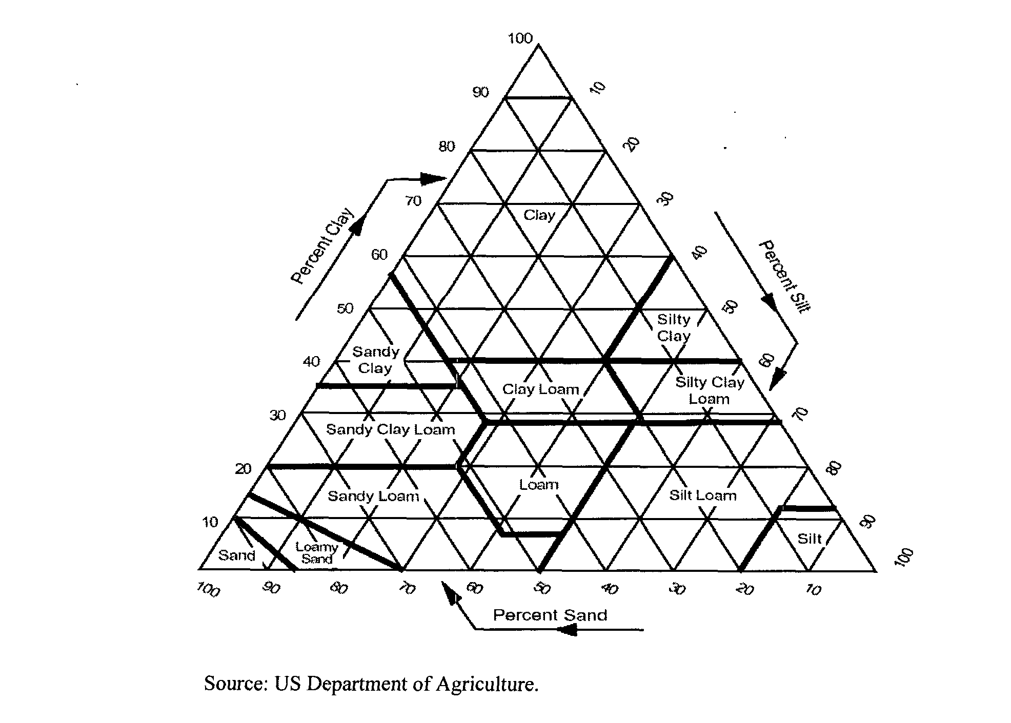
SAND means a particle size category consisting of mineral particles, which are between 0.05 and 2.0 millimeters in equivalent spherical diameter. Also, a soil textural class having 85 percent or more of sand and a content of silt and clay such that the percentage of silt plus 1.5 times the percentage of clay does not exceed 15, as shown in Section 11.C.1 (USDA Soil Textural Triangle).�
SEASONALLY HIGH WATER TABLE means the upper limit of the shallowest zone of saturation which occurs in the soil, identified as prescribed in N.J.A.C. 7:9A-5.8.�
SEDIMENT means solid material, mineral or organic, that is in suspension, is being transported, or has been moved from its site of origin by air, water or gravity as a product of erosion.�
SITE means the lot or lots upon which a major development is to occur or has occurred.�
�
SOIL means all unconsolidated mineral and organic material of any origin, which is not a rock substratum, including sediments below the biologically active and/or weathered zones.�
SOURCE MATERIAL means any material(s) or machinery, located at an industrial facility, which is directly or indirectly related to process, manufacturing or other industrial activities, which could be a source of pollutants in any industrial stormwater discharge to groundwater. Source materials include, but are not limited to, raw materials; intermediate products; final products; waste materials; by-products; industrial machinery and fuels, and lubricants, solvents, and detergents that are related to process, manufacturing, or other industrial activities that are exposed to stormwater.�
STORMWATER means water resulting from precipitation (including rain and snow) that runs off the land's surface, is transmitted to the subsurface, or is captured by separate storm sewers or other sewage or drainage facilities, or conveyed by snow removal equipment.�
STORMWATER INFILTRATION BMP means a basin or other facility constructed within permeable soils that provides temporary storage of stormwater runoff. An infiltration BMP does not normally have a structural outlet to discharge runoff from the stormwater quality design storm. Instead, outflow from an infiltration BMP is through the surrounding soil. The terms "infiltration measure" and "infiltration practice" shall have the same meaning as "stormwater infiltration basin."�
STORMWATER MANAGEMENT MEASURE means any structural or nonstructural strategy, practice, technology, process, program, or other method intended to control or reduce stormwater runoff and associated pollutants, or to induce or control the infiltration or groundwater recharge of stormwater or to eliminate illicit or illegal non-stormwater discharges into stormwater conveyances. This includes, but is not limited to, structural and nonstructural stormwater Best Management Practices described in the New Jersey BMP Manual and designed to meet the standards for stormwater control contained within this ordinance. The terms "stormwater Best Management Practice" and "stormwater BMP" shall have the same meaning as "stormwater management measure."�
STORMWATER RUNOFF means water flow on the surface of the ground or in storm sewers, resulting from precipitation.�
SUITABLE SOIL means unsaturated soil, above the seasonally high water table, which contains less than fifty percent (50%) by volume of coarse fragments and which has a tested permeability rate of between one (1) and twenty (20) inches per hour.�
SURFACE WATER means any waters of the State, which are not groundwater.�
�
TIME OF CONCENTRATION means the time it takes for runoff to travel from the hydraulically most distant point of the drainage area to the point of interest within a watershed.�
TOTAL SUSPENDED SOLIDS means the insoluble solid matter suspended in water and stormwater that is separable by laboratory filtration in accordance with the procedure contained in the "Standard Methods for the Examination of Water and Wastewater" prepared and published jointly by the American Public Health Association, American Water Works Association and the Water Pollution Control Federation. The term "TSS" shall have the same meaning as "Total Suspended Solids."�
TIDAL FLOOD HAZARD AREA means a flood hazard area, which may be influenced by stormwater runoff from inland areas, but which is primarily caused by the Atlantic Ocean.�
WATERS OF THE STATE means the ocean and its estuaries, all springs, streams and bodies of surface and groundwater, whether natural or artificial, within the boundaries of New Jersey or subject to its jurisdiction.�
WATER TABLE means the upper surface of a zone of saturation.�
�
WELL means a bored, drilled or driven shaft, or a dug hole, which extends below the seasonally high water table and which has a depth which is greater than its largest surface dimension.�
WETLANDS mean those lands, which are inundated or saturated by water at a magnitude, duration and frequency sufficient to support the growth of hydrophytes. Wetlands include lands with poorly drained or very poorly drained soils as designated by the National Cooperative Soils Survey of the Soil Conservation Service of the United States Department of Agriculture. Wetlands include coastal wetlands and inland wetlands, including submerged lands. The "New Jersey Pinelands Commission Manual for Identifying and Delineating Pinelands Area Wetlands: A Pinelands Supplement to the Federal Manual for Identifying and Delineating Jurisdictional Wetlands," dated January, 1991, as amended, may be utilized in delineating the extent of wetlands based on the definitions of wetlands and wetlands soils contained in this section, N.J.A.C. 7:50 2.11, 6.4 and 6.5. The term "wetland" shall have the same meaning as "wetlands."�
WET POND means a stormwater facility constructed through filling and/or excavation that provides both permanent and temporary storage of stormwater runoff. It has an outlet structure that creates a permanent pool and detains and attenuates runoff inflows and promotes the settling of pollutants. A stormwater retention basin can also be designed as a multi-stage facility that also provides extended detention for enhanced stormwater quality design storm treatment and runoff storage and attenuation for stormwater quantity management. The term "stormwater retention basin" shall have the same meaning as "wet pond."�
�
SECTION 8: PENALTIES�
Any person who erects, constructs, alters, repairs, converts, maintains, or uses any building, structure or land in violation of this ordinance shall be subject to a fine of not less than one hundred dollars ($100.00) but not more than one thousand dollars ($1,000.00) and/or sentencing to a period of not more than ninety (90) days in jail. Every continuous day that a violation takes place shall be considered a separate occurrence.�
SECTION 9: EFFECTIVE DATE.�
This ordinance shall take effect immediately upon the following:�
A) Certification by the Pinelands Commission in accordance with N.J.A.C. 7:50 Subchapter 3; and�
B) Approval by the county review agency in accordance with N.J.A.0 7:8-4.4.�
SECTION 10: SEVERABILITY.�
If the provisions of any section, subsection, paragraph, subdivision, or clause of this ordinance shall be judged invalid by a court of competent jurisdiction, such order of judgment shall not affect or invalidate the remainder of any section, subsection, paragraph, subdivision or clause of this ordinance.�
SECTION 11: APPENDICES.�
A. Methods for Calculating Groundwater Recharge.�
1. The New Jersey Geological Survey Report GSR-32: A Method for Evaluating Ground-Water Recharge Areas in New Jersey. Available at http://www.njgeology.org/geodata/dgs99-2.htm.�
2. The New Jersey Groundwater Recharge Spreadsheet (NJGRS). Available in the New Jersey BMP Manual, Chapter 6, at http://www.njstormwater.org/bmp_manual2.htm.�
B. NJDEP Nonstructural Stormwater Management Strategies Point System.�
The New Jersey Stormwater Management Rules at N.J.A.C. 7:8-5.2(a), and Section 4.A. of this Ordinance, require nonstructural stormwater management strategies to be incorporated into the site design of a major development. A total of nine strategies are to be used to the maximum extent practical to meet the groundwater recharge, stormwater quality and stormwater quantity requirements of the rules prior to to utilizing structural stormwater management measures. The New Jersey Nonstructural Stormwater Management Strategies Point System(NSPS) provides a tool to assist planners, designers and regulators in determining the strategies have been used to the "maximum extent practical" at a major development as required by the rules. The New Jersey Nonstructural Stormwater Management Strategies Point System (NSPS) User's Guide and Spreadsheet are available at http://www.njstormwater.org.�
C. Soils �
1. USDA Soil Textural Triangle.�
2. Definitions. For the purposes of this appendix, the following terms shall have the meanings herein ascribed to them.�
A-HORIZON means the uppermost mineral horizon in a normal soil profile. The upper part of the A-horizon is characterized by maximum accumulation of finely divided, dark colored organic residues, known as humus, which are intimately mixed with the mineral particles of the soil.�
ARTESIAN ZONE OF SATURATION means a zone of saturation which exists immediately below a hydraulically restrictive horizon, and which has an upper surface, which is at a pressure greater than atmospheric, either seasonally or throughout the year.�
CHROMA means the relative purity or strength of a color, a quantity that decreases with increasing grayness. Chroma is one of the three variables of soil color as defined in the Munsell system of classification.�
CLAY means a particle size category consisting of mineral particles, which are smaller than 0.002 millimeters in equivalent spherical diameter. Also, a soil textural class having more than 40 percent clay, less than 45 percent sand, and less than 40 percent silt, as shown in Section 11.C.1 (USDA Soil Textural Triangle).�
CLAY LOAM means a soil textural class having 27 to 40 percent clay and 20 to 45 percent sand, as shown in Section 11.C.1 (USDA Soil Textural Triangle).�
COARSE FRAGMENT means a rock fragment contained within the soil which is greater than two millimeters in equivalent spherical diameter or which is retained on a two-millimeter sieve.�
COUNTY SOIL SURVEY REPORT means a report prepared by the US Department of Agriculture, Natural Resources Conservation Service which includes maps showing the distribution of soil mapping units throughout a particular county together with narrative descriptions of the soil series shown and other information relating to the uses and properties of the various soil series.�
DIRECT SUPERVISION means control over and direction of work carried out by others with full knowledge of and responsibility for such work.�
EQUIVALENT SPHERICAL DIAMETER of a particle means the diameter of a sphere, which has a volume equal to the volume of the particle.�
EXCESSIVELY COARSE HORIZON means a horizon of limited thickness within the soil profile which provides inadequate removal of pollutants from stormwater due to a high coarse fragment content, excessively coarse texture and/or excessively rapid permeability.�
EXCESSIVELY COARSE SUBSTRATUM means a substratum below the soil profile which extends beyond the depth of soil profile pits and borings and which provides inadequate removal of pollutants from stormwater due to a high coarse fragment content, excessively coarse texture and/or excessively rapid permeability.�
EXTREMELY FIRM CONSISTENCE means a type of soil material whose moist aggregated mass crushes only under very strong pressure; cannot be crushed between the thumb and forefinger and shall be broken apart bit by bit.�
FIRM CONSISTENCE means a type of soil material who's moist aggregated mass crushes under moderate pressure between the thumb and forefinger but resistance is distinctly noticeable.�
HARD CONSISTENCE means a type of soil material whose dry aggregated mass is moderately resistant to pressure; can be broken in the hands without difficulty but is barely breakable between the thumb and forefinger.�
HUE means the dominant spectral color, one of the three variables of soil color defined within the Munsell system of classification.�
HYDRAULICALLY RESTRICTIVE HORIZON means a horizon within the soil profile which slows or prevents the downward or lateral movement of water and which is underlain by permeable soil horizons or substrata. Any soil horizon which has a saturated permeability less than one (1.0) inch per hour is hydraulically restrictive.�
HYDRAULICALLY RESTRICTIVE SUBSTRATUM means a substratum below the soil profile which slows or prevents the downward or lateral movement of water and which extends beyond the depth of profile pits or borings or to a massive substratum. A substratum which has a saturated permeability less than one (1.0) inch per hour is hydraulically restrictive.�
LOAMY SAND means a soil textural class, as shown in Section 11.C.1 (USDA Soil Textural Triangle), that has a maximum of 85 to 90 percent (85-90%) sand with a percentage of silt plus one and a half (1.5) times the percentage of clay not in excess of fifteen (15); or a minimum of 70 to 85 percent (70-85%) sand with a percentage of silt plus one and a half (1.5) times the percentage of clay not in excess of thirty (30).�
LOWER PLASTIC LIMIT means the moisture content corresponding to the transition between the plastic and semi-solid states of soil consistency. This corresponds to the lowest soil moisture content at which the soil can be molded in the fingers to form a rod or wire, one-eighth (1/8) inches in thickness, without crumbling.�
MOTTLING means a color pattern observed in soil consisting of blotches or spots of contrasting color. The term "mottle" refers to an individual blotch or spot. The terms "color variegation," "iron depletion" and "iron concentration" are equivalent to the term "mottling." Mottling due to redoximorphic reactions is an indication of seasonal or periodic and recurrent saturation.�
MUNSELL SYSTEM means a system of classifying soil color consisting of an alpha- numeric designation for hue, value and chroma, such as "7.5 YR 6/2," together with a descriptive color name, such as "strong brown."�
O-HORIZON means a surface horizon, occurring above the A-horizon in some soils, which is composed primarily of undecomposed or partially decomposed plant remains, which have not been incorporated into the mineral soil.�
PERCHED ZONE OF SATURATION means a zone of saturation which occurs immediately above a hydraulically restrictive horizon and which is underlain by permeable horizons or substrata, which are not permanently or seasonally saturated.�
PIEZOMETER means a device consisting of a length of metal or plastic pipe, open at the bottom or perforated within a specified interval, and used for the determination of depth to water, permeability or hydraulic head within a specific soil horizon or substratum.�
PLATY STRUCTURE is characterized by a soil aggregate, which has one axis distinctly shorter than the other two and are oriented with the short axis vertical.�
REGIONAL ZONE OF SATURATION means a zone of saturation, which extends vertically without interruption below the depth of soil borings and profile pits.�
SANDY CLAY means a soil textural class having 35 percent (35%) or more of clay and 45 percent (45%) or more of sand, as shown in Section 11.C.1 (USDA Soil Textural Triangle).�
SANDY LOAM means a soil textural class, as shown in Section 11.C.1 (USDA Soil Textural Triangle), that has a maximum of 20 percent clay, and the percentage of silt plus twice the percentage of clay exceeds 30, and contains 52 percent or more sand; or less than 7 percent clay, less than 50 percent silt, and between 43 and 52 percent sand.�
SILT means a particle size category consisting of mineral particles, which are between 0.002 and 0.05 millimeters in equivalent spherical diameter. It also means a soil textural class having 80 percent or more of silt and 12 percent or less of clay, as shown in Section 11.C.1 (USDA Soil Textural Triangle).�
�
SILT LOAM means a soil textural class having 50 percent or more of silt and 12 to 27 percent of clay; or 50 to 80 percent of silt and less than 12 percent of clay, as shown in Section 11.C.1 (USDA Soil Textural Triangle).�
SILTY CLAY means a soil textural class having 40 percent or more of clay and 40 percent or more of silt, as shown in Section 11.C.1 (USDA Soil Textural Triangle).�
SILTY CLAY LOAM means a soil textural class having 27 to 40 percent of clay and less than 20 percent of sand, as shown in Section 11.C.1 (USDA Soil Textural Triangle).�
SOIL AGGREGATE means a naturally occurring unit of soil structure consisting of particles of sand, silt, clay, organic matter, and coarse fragments held together by the natural cohesion of the soil.�
SOIL COLOR means the soil color name and Munsell color designation determined by comparison of the moist soil with color chips contained in a Munsell soil color book.�
SOIL CONSISTENCE means the resistance of a soil aggregate or clod to being crushed between the fingers or broken by the hands. Terms for describing soil consistence described are in N.J.A.C. 7:9A-5.3(h).�
SOIL HORIZON means a layer within a soil profile differing from layers of soil above and below it in one or more of the soil morphological characteristics including color, texture, coarse fragment content, structure, consistence and mottling.�
SOIL LOG means a description of the soil profile, which includes the depth, thickness, color, texture, coarse fragment content, mottling, structure and consistence of each soil horizon or substratum.�
SOIL MAPPING UNIT means an area outlined on a map in a County Soil Survey Report and marked with a letter symbol designating a soil phase, a complex of two or more soil phases, or some other descriptive term where no soil type has been identified.�
SOIL PHASE means a specific type of soil which is mapped by the Natural Resources Conservation Service and which belongs to a soil series described within the County Soil Survey Report.�
SOIL PROFILE means a vertical cross-section of undisturbed soil showing the characteristic horizontal layers or horizons of the soil, which have formed as a result of the combined effects of parent material, topography, climate, biological activity and time.�
SOIL SERIES means a grouping of soil types possessing a specific range of soil profile characteristics, which are described within the County Soil Survey Report. Each soil series may consist of several "soil phases" which may differ in slope, texture of the surface horizon or stoniness.�
SOIL STRUCTURAL CLASS means one of the shape classes of soil structure described in N.J.A.C. 7:9A-5.3(g).�
SOIL STRUCTURE means the naturally occurring arrangement, within a soil horizon, of sand, silt and clay particles, coarse fragments and organic matter, which are held together in clusters or aggregates of similar shape and size.�
SOIL TEST PIT means an excavation made for the purpose of exposing a soil profile, which is to be described.�
SOIL TEXTURAL CLASS means one of the classes of soil texture defined within the USDA system of classification. (Soil Survey Manual, Agricultural Handbook No. 18, USDA Soil Conservation Service 1962.)�
SOIL TEXTURE means the relative proportions of sand, silt and clay in that portion of the soil, which passes through a sieve with two-millimeter openings.�
STATIC WATER LEVEL means the depth below the ground surface or the elevation with respect to some reference level, of the water level observed within a soil profile pit or boring, or within a piezometer, after this level has stabilized or become relatively constant with the passage of time.�
SUBSTRATUM means a layer of soil or rock material present below the soil profile and extending beyond the depth of soil borings or profile pits.�
�
USDA SYSTEM OF CLASSIFICATION means the system of classifying soil texture used by the United States Department of Agriculture, which defines 12 soil textural classes based upon the weight percentages of sand, silt and clay in that portion of the soil, which passes through a sieve with two-millimeter (2 mm) openings. The soil textural classes are shown graphically on the USDA Soil Textural Triangle, as shown in Section 11.C.1.�
VALUE means the relative lightness or intensity of a color, one of the three variables of soil color defined within the Munsell system of classification.�
VERY FIRM CONSISTENCE is characterized by a moist soil which crushes under strong pressure; barely crushable between thumb and forefinger.�
VERY HARD CONSISTENCE is characterized by a dry soil which is resistant to pressure, can be broken in the hands only with difficulty; not breakable between the thumb and forefinger.�
ZONE OF SATURATION means a layer within or below the soil profile, which is saturated with ground water either seasonally or throughout the year. This includes both regional and perched zones.�
�
3. Methods for Assessing Soil Suitability for Infiltration Stormwater Management BMPs. The results of a subsurface investigation shall serve as the basis for the site selection and design of stormwater infiltration BMPs. The subsurface investigation shall include, but not be limited to, a series of soil test pits and soil permeability tests conducted in accordance with the following: �
a) All soil test pits and soil permeability results shall be performed under the direct supervision of a Professional Engineer. All soil logs and permeability test data shall be accompanied by a certification by a Professional Engineer. The results and location (horizontal and vertical) of all soil test pits and soil permeability tests, both passing and failing, shall be reported to Pemberton Township. �
b) During all subsurface investigations and soil test procedures, adequate safety measures shall be taken to prohibit unauthorized access to the excavations at all times. It is the responsibility of persons performing or witnessing subsurface investigations and soil permeability tests to comply with all applicable Federal, State and local laws and regulations governing occupational safety. �
c) A minimum of two (2) soil test pits shall be excavated within the footprint of any proposed infiltration BMP to determine the suitability and distribution of soil types present at the site. Placement of the test pits shall be within twenty (20) feet of the basin perimeter, located along the longest axis bisecting the BMP. For BMPs larger than ten thousand (10,000) square feet in area, a minimum of one (1) additional soil test pit shall be conducted within each additional area of ten thousand (10,000) square feet. The additional test pit(s) shall be placed approximately equidistant to other test pits, so as to provide adequate characterization of the subsurface material. In all cases, where soil and or groundwater properties vary significantly, additional test pits shall be excavated in order to accurately characterize the subsurface conditions below the proposed infiltration BMP. Soil test pits shall extend to a minimum depth of eight (8) feet below the lowest elevation of the basin bottom or to a depth that is at least two (2) times the maximum potential water depth in the proposed infiltration BMP, whichever is greater. �
d) A soil test pit log shall be prepared for each soil test pit. The test pit log shall, at a minimum, provide the elevation of the existing ground surface, the depth and thickness (in inches) of each soil horizon or substratum, the dominant matrix or background and mottle colors using the Munsell system of classification for hue, value and chroma, the appropriate textural class as shown on the USDA textural triangle, the volume percentage of coarse fragments (larger than two (2) millimeters in diameter), the abundance, size, and contrast of mottles, the soil structure, soil consistence, and soil moisture condition, using standard USDA classification terminology for each of these soil properties. Soil test pit logs shall identify the presence of any soil horizon, substratum or other feature that exhibits an in-place permeability rate less than one (1) inch per hour. �
e) Each soil test pit log shall report the depth to seasonally high water level, either perched or regional, and the static water level based upon the presence of soil mottles or other redoximorphic features, and observed seepage or saturation. Where redoxomorphic features including soil mottles resulting from soil saturation are present, they shall be interpreted to represent the depth to the seasonal high water table unless soil saturation or seepage is observed at a higher level. When the determination of the seasonally high water table shall be made in ground previously disturbed by excavation, direct observation of the static water table during the months of January through April shall be the only method permitted. �
f) Any soil horizon or substratum which exists immediately below a perched zone of saturation shall be deemed by rule to exhibit unacceptable permeability (less than one (1) inch per hour). The perched zone of saturation may be observed directly, inferred based upon soil morphology, or confirmed by performance of a hydraulic head test as defined at N.J.A.C. 7:9A-5.9.�
g) Stormwater infiltration BMPs shall not be installed in soils that exhibit artesian groundwater conditions. A permeability test shall be conducted in all soils that immediately underlie a perched zone of saturation. Any zone of saturation which is present below a soil horizon which exhibits an in-place permeability of less than 0.2 inches per hour shall be considered an artesian zone of saturation unless a minimum one foot thick zone of unsaturated soil, free of mottling or other redoximorphic features and possessing a chroma of four or higher, exists immediately below the unsuitable soil. �
h) A minimum of one (1) permeability test shall be performed at each soil test pit location. The soil permeability rate shall be determined using test methodology as prescribed in N.J.A.C. 7:9A-6.2 (Tube Permeameter Test), 6.5 (Pit Bailing Test) or 6.6 (Piezometer Test). When the tube permeameter test is used, a minimum of two replicate samples shall be taken and tested. Alternative permeability test procedures may be accepted by the approving authority provided the test procedure attains saturation of surrounding soils, accounts for hydraulic head effects on infiltration rates, provides a permeability rate with units expressed in inches per hour and is accompanied by a published source reference. Examples of suitable sources include hydrogeology, geotechnical or engineering text and design manuals, proceedings of American Society for Testing and Materials (ASTM) symposia, or peer-review journals. Neither a Soil Permeability Class Rating Test, as described in N.J.A.C. 7:9A-6.3, nor a Percolation Test, as described in N.J.A.C. 7:9A-6.4, are acceptable tests for establishing permeability values for the purpose of complying with this ordinance. �
i) Soil permeability tests shall be conducted on the most hydraulically restrictive horizon or substratum to be left in place below the basin as follows. Where no soil replacement is proposed, the permeability tests shall be conducted on the most hydraulically restrictive horizon or substratum within four (4) feet of the lowest elevation of the basin bottom or to a depth equal to two (2) times the maximum potential water depth within the basin, whichever is greater. Where soil replacement is proposed, the permeability tests shall be conducted within the soil immediately below the depth of proposed soil replacement or within the most hydraulically restrictive horizon or substratum to a depth equal to two (2) times the maximum potential water depth within the basin, whichever is greater. Permeability tests may be performed on the most hydraulically restrictive soil horizons or substrata at depths greater than those identified above based upon the discretion of the design or testing engineer. The tested infiltration rate should then be divided by two (2) to establish the soil's design permeability, rate. Such division will provide a 100% safety factor to the tested rate. �
j) The minimum acceptable "tested permeability rate" of any soil horizon or substratum shall be one (1) inch per hour. Soil materials that exhibit tested permeability rates slower than one (1) inch per hour shall be considered unsuitable for stormwater infiltration. The maximum reportable "tested permeability rate" of any soil horizon or substratum shall be no greater than twenty (20) inches per hour regardless of the rate attained in the test procedure. �
k) After all construction activities have been completed on the development site and the finished grade has been established in the infiltration BMP, a minimum of one permeability test shall be conducted within the most hydraulically restrictive soil horizon or substratum below the as-built BMP to ensure the performance of the infiltration BMP is as designed. Hand tools and manual permeability test procedures shall be used for the purpose of confirming BMP performance. In addition, the infiltration BMP shall be flooded with water sufficient to demonstrate the performance of the BMP. Test results shall be certified to the municipal engineer.�
l) A groundwater mounding analysis shall be provided for each stormwater infiltration BMP. The groundwater mounding analysis shall calculate the maximum height of the groundwater mound based upon the volume of the maximum design storm. The Professional Engineer conducting the analysis shall provide the municipal engineer with the methodology and supporting documentation for the mounding analysis used and shall certify to Pemberton Township, based upon the analysis, that the groundwater mound will not cause stormwater or groundwater to breakout to the land surface or cause adverse impact to adjacent surface water bodies, wetlands or subsurface structures including but not limited to basements and septic systems. If there is more than one infiltration BMP proposed, the model shall indicate if and how the mounds will interact. The mounding analysis shall be calculated using the most restrictive soil horizon that will remain in place within the explored aquifer thickness unless alternative analyses is authorized by the municipal engineer. The mounding analysis shall be accompanied by a cross section of the infiltration BMP and surrounding topography and the mound analysis shall extend out to the point(s) at which the mound intersects with the preexisting maximum water table elevation. �
m) The applicant shall demonstrate that stormwater infiltration BMPs meet the seventy-two (72) hour drain time requirement established in Section 5.B.1 of this ordinance.�
D. Pretreatment measures for infiltration BMPs. By reducing incoming velocities and capturing coarser sediments, pretreatment can extend the functional life and increase the pollutant removal capability of infiltration measures. Therefore, the installation of pretreatment measures is recommended for all development sites. Pretreatment measures may include, but are not limited to, the following:�
1. Vegetative filter strips;�
2. Bioretention systems. Used in conjunction with a bioretention system, the infiltration basin takes the place of the standard underdrain;�
3. Sand filters;�
4. Grassed swales; and�
5. Detention basins.�
E. Collection and Conveyance.�
1. Bicycle-safe inlet grates. Site development plans that incorporate site design features that help to prevent discharge of trash and debris from drainage systems shall comply with the following standard to control passage of solid and floatable materials through storm drain inlets. For purposes of this paragraph, "solid and floatable materials" means sediment, debris, trash, and other floating, suspended, or settleable solids. �
a) Design engineers shall use either of the following grates whenever they use a grate in pavement or another ground surface to collect stormwater from that surface into a storm drain or surface water body under that grate:�
i. The New Jersey Department of Transportation (NJDOT) bicycle safe grate, which is described in Chapter 2.4 of the NJDOT Bicycle Compatible Roadways and Bikeways Planning and Design Guidelines (April 1996); or �
ii. A different grate, if each individual clear space in that grate has an area of no more than seven (7) square inches, or is no greater than one half (0.5) inch across the smallest dimension. Examples of grates subject to this standard include grates in grate inlets, the grate portion (non-curb-opening portion) of combination inlets, grates on storm sewer manholes, ditch grates, trench grates, and grates of spacer bars in slotted drains. Examples of ground surfaces include surfaces of roads (including bridges), driveways, parking areas, bikeways, plazas, sidewalks, lawns, fields, open channels, and stormwater basin floors. �
b) Whenever design engineers use a curb-opening inlet, the clear space in that curb opening (or each individual clear space, if the curb opening has two or more clear spaces) shall have an area of no more than seven (7) square inches, or be no greater, than two (2) inches across the smallest dimension. �
c) This standard does not apply:�
i. Where the review agency determines that this standard would cause inadequate hydraulic performance that could not practicably be overcome by using additional or larger storm drain inlets that meet these standards; �
ii. Where flows from the water quality design storm as specified in Section 3 are conveyed through any device (e.g., end-of-pipe netting facility, manufactured treatment device, or a catch basin hood) that is designed, at a minimum, to prevent delivery of all solid and floatable materials that could not pass through one of the following:�
(a) A rectangular space four and five-eighths (4 and 5/8) inches long and one and one-half (1.5) inches wide (this option does not apply for outfall netting facilities); or�
(b) A bar screen having a bar spacing of one-half (0.5) inch. �
iii. Where flows are conveyed through a trash rack that has parallel bars with one (1) inch spacing between the bars, to the elevation of the water quality design storm as specified in Section 3 of this ordinance; or �
iv. Where the NJDEP determines, pursuant to the New Jersey Register of Historic Places Rules at N.J.A.C. 7:4-7.2(c), that action to meet this standard is an undertaking that constitutes an encroachment or will damage or destroy the New Jersey Register listed historic property.�
2. Catch basins. Catch basins are storm drain inlets with or without sumps. Catch basins may provide pretreatment for other stormwater BMPs by capturing large sediments. The sediment and pollutant removal efficiency of catch basins depends on the size of the sump and the performance of routine maintenance to retain the available sediment storage space in the sump. Where catch basins with sumps are proposed, the minimum two feet separation between the bottom of the sump and seasonally high water table shall be provided.�
3. Open or perforated conveyance piping. Where adequate separation to the seasonal high water table exists, stormwater from the development site may be conveyed to a stormwater basin via a system of perforated pipes. These pipes may be made of PVC or corrugated polyethylene and are available with perforations of varying size and spacing. Perforated pipe specifications shall be certified by a Professional Engineer. A Professional Engineer shall certify that perforated conveyance piping will not act to intercept the seasonal high water table and convey groundwater to the stormwater basin. All open or perforated stormwater conveyance systems shall be installed with a minimum separation of two (2) feet from the seasonal high water table.�
SECTION 12: ADDITIONAL SOURCES FOR TECHNICAL GUIDANCE.�
A. NJDEP Technical Guidance Sources.�
1. New Jersey BMP Manual. Available from the Division of Watershed Management, New Jersey Department of Environmental Protection, PO Box 418, Trenton, New Jersey 08625; or online at http://www.njstormwater.org.�
2. NJDEP Stormwater Management Facilities Maintenance Manual. Available from the Division of Watershed Management, New Jersey Department of Environmental Protection, PO Box 418, Trenton, New Jersey 08625; or online at http://njedl.rutgers.edu/ftp/PDFs/1188.pdf.�
B. Additional Guidance Sources.�
1. New Jersey Pinelands Commission, PO Box 7, 15 Springfield Road, New Lisbon, New Jersey 08064; Phone: 609-894-7300; Website: http://www.state.nj.us/pinelands.�
2. State Soil Conservation Committee Standards for Soil Erosion and Sediment Control in New Jersey. Available from all State Soil Conservation Districts, including Burlington County Soil Conservation District, Tiffany Square, Suite 100, 1289 Route 38, Hainesport, New Jersey 08036; Phone: 609-267-7410; Fax: 609-267-3347; Website: http://bscd.org.�
3. State Soil Conservation Districts. The local Soil Conservation District is the Burlington County Soil Conservation District, Tiffany Square, Suite 100, 1289 Route 38, Hainesport, New Jersey 08036; Phone: 609-267-7410; Fax: 609-267- 3347; Website: http://bscd.org.�
4. New Jersey Department of Transportation, PO Box 600, Trenton, NJ 08625-0600; Phone: 609-530-3536; Website: http://www.state.nj.us/transportation.�
**Webmasters Note: The previous section has been amended as per Ordinance No. 16-2007.�

