
�
SECTION I: PURPOSE�
�
A. Purpose�
1. It is hereby determined that: �
a) Land development projects and associated disturbance of vegetation and soil and changes in land cover, including increases in impervious cover, alter the hydrologic response of local watersheds and increase stormwater runoff rates and volumes. If inadequately or improperly managed, this stormwater runoff can deplete groundwater resources and increase flooding, stream channel erosion, and sediment transport and deposition. This stormwater runoff can also contribute to increased quantities of waterborne pollutants. �
b) Increases of stormwater runoff, soil erosion and nonpoint source pollutants have occurred in the past as a result of land development, and contribute to the degradation of the water resources of Pemberton Township. �
c) Certain lands of Pemberton Township lie within the Pinelands Area, and therefore, development in this portion of Pemberton Township is subject to the requirements of the Pinelands Protection Act (N.J.S.A. 13:18A-1 et seq.) and the implementing regulations and minimum standards contained in the Pinelands Comprehensive Management Plan (N.J.A.C. 7:50-1.1 et seq.) (CMP). The purpose and intent of these regulations and standards is to promote orderly development of the Pinelands so as to preserve and protect the significant and unique natural, ecological, agricultural, archaeological, historical, scenic, cultural and recreational resources of the Pinelands. �
d) Pinelands Area resources are to be protected in accordance with Pinelands Comprehensive Management Plan at N.J.A.C. 7:50 et seq., New Jersey's Stormwater Management Rules at N.J.A.C. 7:8-1.1 et seq. and New Jersey's surface water quality antidegradation policies contained in the New Jersey Surface Water Quality Standards at N.J.A.C. 7:9B-1.1 et seq. �
e) Increased stormwater rates and volumes and the sediments and pollutants associated with stormwater runoff from future development projects within the Pinelands Area have the potential to adversely affect Pemberton Township's streams and water resources and the streams and water resources of downstream municipalities. �
f) Stormwater runoff, soil erosion and nonpoint source pollution can be controlled and minimized through the regulation of stormwater runoff from development sites. �
�
g) It is in the public interest to regulate the discharge of stormwater runoff from "major development" projects, as defined in Section 7 of this ordinance, conducted within the Pinelands Area, as provided in this ordinance, in order to control and minimize increases in stormwater runoff rates and volumes, to maintain groundwater recharge, and to control and minimize soil erosion, stream channel erosion and nonpoint source pollution associated with stormwater runoff.�
2. Therefore, it is the purpose of this ordinance to establish minimum stormwater management requirements and controls for major development, consistent with the statewide stormwater requirements at N.J.A.C. 7:8, the regulations and standards contained in the Pinelands CMP, and the provisions of the adopted master plan and land use ordinances of Pemberton Township.�
B. Management Techniques.�
1. In order to achieve the goals for stormwater control set forth in the Municipal Stormwater Management Plan, Pemberton Township has identified the following management techniques: �
a) Implementation of multiple stormwater management Best Management Practices (BMPs) may be necessary to achieve the performance standards for stormwater runoff quantity and rate, groundwater recharge, erosion control, and stormwater runoff quality established through this ordinance. �
b) Compliance with the stormwater runoff quantity and rate, groundwater recharge, erosion control, and stormwater runoff quality standards established through N.J.A.C. 7:8-1.1 et seq., and this ordinance, shall be accomplished to the maximum extent practicable through the use of nonstructural BMPs, before relying on structural BMPs. Nonstructural BMPs are also known as Low Impact Development (LID) techniques. �
c) Nonstructural BMPs shall include both environmentally sensitive site design and source controls that prevent pollutants from being placed on the site or from being exposed to stormwater. �
d) Source control plans shall be developed based upon physical site conditions and the origin, nature and the anticipated quantity or amount of potential pollutants. �
e) Structural BMPs, where necessary shall be integrated with nonstructural stormwater management strategies and proper maintenance plans.�
When using structural BMPs, multiple stormwater management measures, smaller in size and distributed spatially throughout the land development site, shall be used wherever possible to achieve the performance standards for water quality, quantity and groundwater recharge established through this ordinance before relying on a single, larger stormwater management measure to achieve these performance standards.�
C. Applicability. �
�
1. This ordinance shall apply to: �
a) All site plans and subdivisions for major developments occurring within the Pinelands Area that require preliminary or final site plan or subdivision review; and �
b) All major development projects undertaken by Pemberton Township.�
D. Procedures. �
In addition to other development review procedures set forth in the Code of Pemberton Township, major developments located within the Pinelands Area shall comply with the stormwater management requirements and specifications set forth in this ordinance. New agricultural development that meets the definition of major development in Section 7 of this ordinance shall be submitted to the appropriate Soil Conservation District for review and approval in accordance with the requirements of N.J.A.C. 7.8-5.4(b).�
E. Compatibility with Other Permit and Ordinance Requirements. �
1. Development approvals issued for subdivisions and site plans pursuant to this ordinance are to be considered an integral part of development approvals under the subdivision and site plan review process and do not relieve the applicant of the responsibility to secure required permits or approvals for activities regulated by any other applicable ordinance, code, rule, regulation, statute, act or other provision of law.�
2. In their interpretation and application, the provisions of this ordinance shall be held to be the minimum requirements for the promotion of the public health, safety, and general welfare. This ordinance is not intended to interfere with, abrogate, or annul any other ordinances, rule or regulation, statute, or other provision of law except that, where any provision of this ordinance imposes restrictions different from those imposed by any other ordinance, rule or regulation, or other provision of law, the more restrictive or stringent provisions or higher standards shall control.�
3. In the event that a regional stormwater management plan(s) is prepared and formally adopted pursuant to N.J.A.C. 7:8-1.1 et seq. for any drainage area(s) or watershed(s) of which Pemberton Township is a part, the stormwater provisions of such a plan(s) shall be adopted by Pemberton Township within one year of the adoption of a Regional Stormwater Management Plan (RSWMP) as an amendment to an Areawide Water Quality Management Plan. Local ordinances proposed to implement the RSWMP shall be submitted to the Commission for certification within six months of the adoption of the RSWMP per N.J.A.C. 7:8 and the Pinelands CMP (N.J.A.C. 7:50.)�
SECTION 2: REQUIREMENTS FOR A SITE DEVELOPMENT STORMWATER PLAN.�
A. Submission of Site Development Stormwater Plan.�
�
1. Whenever an applicant seeks municipal approval of a site development that is subject to this ordinance, the applicant shall submit all of the required components of the Checklist for the Site Development Stormwater Plan at Section 2.0 below as part of the applicant's application for subdivision or site plan approval. These required components are in addition to any other information required under any provisions of Pemberton Township's land use ordinance or by the Pinelands Commission pursuant to N.J.A.C. 7:50-1.1 et seq.�
2. The applicant shall demonstrate that the site development project meets the standards set forth in this ordinance.�
3. The applicant shall submit three (3) paper copies and one copy on compact disk of the materials listed in the checklist for site development stormwater plans in accordance with Section 3.0 of this ordinance.�
B. Site Development Stormwater Plan Approval.�
1. The applicant's site development stormwater plan shall be reviewed as a part of the subdivision or site plan review process by the municipal board or official from whom municipal approval is sought. That municipal board or official shall consult the engineer retained by the Planning and/or Zoning Board (as appropriate) to determine if all of the checklist requirements have been satisfied and to determine if the project meets the standards set forth in this ordinance.�
C. Checklist Requirements. Any application for approval of a major development shall include submission of all required plans and reports in electronic format on compact disk. All required engineering plans shall be submitted to Pemberton Township in CAD Format, AutoCAD Version 15 or higher registered and rectified to NJ State Plane Feet NAD 83 or Shape File Format NJ State Plane Feet NAD 83. Reports shall be submitted in electronic file formats such as pdf, word processing, database or spreadsheet files. Six (6) paper copies and one copy on compact disk of all required plans and reports shall be submitted.�
1. Topographic Base Map. The applicant shall submit a topographic base map of the site which extends a minimum of two hundred (200) feet beyond the limits of the proposed development, at a scale of one (1) inch = two hundred (200) feet or greater, showing one (1) foot contour intervals. The map shall indicate the following: existing surface water drainage, shorelines, steep slopes, soils, highly erodible soils, perennial or intermittent streams that drain into or upstream of any Category One or Pinelands Waters, wetlands and floodplains along with their appropriate buffer strips, marshlands and other wetlands, pervious or vegetative surfaces, existing man-made structures, roads, bearing and distances of property lines, and significant natural and manmade features not otherwise shown. Pemberton Township may require upstream tributary drainage system information for use in evaluation of the application.�
2. Environmental Site Analysis. The applicant shall submit a written description along with the drawings of the natural and man-made features of the site and its environs. This description should include: �
�
a) A discussion of environmentally critical areas, soil conditions, slopes, wetlands, waterways and vegetation on the site. Particular attention should be given to unique, unusual or environmentally sensitive features and to those that provide particular opportunities for or constraints on development; and �
b) Detailed soil and other environmental conditions on the portion of the site proposed for installation of any stormwater BMPs, including, at a minimum: soils report based on onsite soil tests; locations and spot elevations in plan view of test pits and permeability tests; permeability test data and calculations; and any other required soil data (e.g., mounding analyses results) correlated with location and elevation of each test site; cross-section of proposed stormwater BMP with side-by-side depiction of soil profile drawn to scale and seasonal high water table elevation identified; and any other information necessary to demonstrate the suitability of the specific proposed structural and nonstructural stormwater management measures relative to the environmental conditions on the portion(s) of the site proposed for implementation of those measures.�
3. Project description and site plan(s). The applicant shall submit a map (or maps) at the scale of the topographical base map indicating the location of existing and proposed buildings, roads, parking areas, utilities, structural facilities for stormwater management and sediment control, and other permanent structures. The map(s) shall also clearly show areas where alterations will occur in the natural terrain and cover, including lawns and other landscaping, and seasonal high groundwater elevations. A written description of the site plan and justification for proposed changes in natural conditions shall also be provided.�
a) The applicant shall submit a detailed Land Use Planning and Source Control Plan which provides a description of how the site will be developed to meet the erosion control, groundwater recharge and stormwater runoff quantity and quality standards at Section 4 through use of nonstructural or low impact development techniques and source controls to the maximum extent practicable before relying on structural BMPs. The Land Use Planning and Source Control Plan shall include a detailed narrative and associated illustrative maps and/or plans that specifically address how each of the following nine (9) nonstructural strategies identified in Subchapter 5 of the NJDEP Stormwater Management Rules (N.J.A.C. 7:8-5) and set forth below (4.a. i. through ix.) will be implemented to the maximum extent practicable to meet the standards at Section 4 of this ordinance on the site. If one or more of the nine (9) nonstructural strategies will not be implemented on the site, the applicant shall provide a detailed rationale establishing a basis for the contention that use of the strategy is not practicable on the site.�
i. Protect areas that provide water quality benefits or areas particularly susceptible to erosion and sediment loss; �
ii. Minimize impervious surfaces and break up or disconnect the flow of runoff over impervious surfaces; �
�
iii. Maximize the protection of natural drainage features and vegetation; �
iv. Minimize the decrease in the "time of concentration" from predevelopment to post-development;�
v. Minimize land disturbance including clearing and grading; �
vi. Minimize soil compaction; �
vii. Provide low-maintenance landscaping that provides for the retention and planting of native plants and minimizes the use of lawns, fertilizers and pesticides, in accordance with N.J.A.C. 7:50- 6.24; �
viii. Provide vegetated open-channel conveyance systems discharging into and through stable vegetated areas; and �
ix. Provide other source controls to prevent or minimize the use or exposure of pollutants at the site in order to prevent or minimize the release of those pollutants into stormwater runoff. These source controls shall include, but are not limited to:�
(1) Site design features that help to prevent accumulation of trash and debris in drainage systems;�
(2) Site design features that help to prevent discharge of trash and debris from drainage systems;�
(3) Site design features that help to prevent and/or contain spills or other harmful accumulations of pollutants at industrial or commercial developments; and�
(4) Applying fertilizer in accordance with the requirements established under the Soil Erosion and Sediment Control Act, N.J.S.A. 4:24-39 et seq., and implementing rules, when establishing vegetation after land disturbance. �
b) For sites where stormwater will be generated from "high pollutant loading areas" or where stormwater will be exposed to "source material," as defined in Section 7 of this ordinance, the applicant shall also demonstrate in the Land Use Planning and Source Control Plan that the requirements of Section 4 have been met. �
c) The use of nonstructural strategies to meet the performance standards in Section 4 of this ordinance is not required for development sites creating less than one (1) acre of disturbance or for development sites creating less than one-quarter (1/4) acre of impervious surface. However, each application for major development and any other application where Pemberton Township otherwise requires a landscaping plan shall contain a landscaping or revegetation plan in accordance with the CMP standards at N.J.A.C. 7:50-6.24(c).�
5. Stormwater Management Facilities Map. The applicant shall submit a map, at the same scale as the topographic base map, depicting the following information: �
a) The total area to be disturbed, paved and/or built upon, proposed surface contours, land area to be occupied by the stormwater management facilities and the type of vegetation thereon, and details of the proposed plan to manage and dispose of stormwater; and �
b) Details of all stormwater management facility designs, during and after construction, including discharge provisions, discharge capacity for each outlet at different levels of detention (if applicable) and emergency spillway provisions with maximum discharge capacity of each spillway.�
6. Calculations (groundwater recharge and stormwater runoff rate, volume and quality). The applicant shall submit comprehensive hydrologic and hydraulic design calculations for the pre-development and post-development conditions for the design storms specified in Section 3. The standards for groundwater recharge and stormwater runoff rate, volume and quality required by Section 4 shall be met using the methods, calculations and assumptions provided in Section 3.�
7. Inspection, Maintenance and Repair Plan. The applicant shall submit a detailed plan describing how the proposed stormwater management measure(s) shall meet the maintenance and repair requirements of Section 6 of this ordinance. Said plan shall include, at a minimum, the following elements: �
a) The frequency with which inspections will be made; �
b) The specific maintenance tasks and requirements for each proposed structural and nonstructural BMP; �
c) The name, address and telephone number for the entity responsible for implementation of the maintenance plan; �
d) The reporting requirements; and �
e) Copies of the inspection and maintenance reporting sheets.�
8. Exception from submission requirements. An exception may be granted from submission of any of these required components (except 7. above, Inspection, Maintenance, and Repair Plan) if its absence will not materially affect the review process. However, items required pursuant to the application requirements in the Pinelands CMP (N.J.A.C. 7:50-4.2(b) shall be submitted to the NJ Pinelands Commission unless the Executive Director waives or modifies the application requirements.�
SECTION 3: METHODOLOGIES FOR THE CALCULATION OF STORMWATER RUNOFF RATE AND VOLUME, STORMWATER RUNOFF QUALITY, AND GROUNDWATER RECHARGE.�
A. Method of Calculating Stormwater Runoff Rate and Volume.�
�
1. In complying with the Stormwater Runoff Quantity and Rate Standards in Section 4.B, the design engineer shall calculate the stormwater runoff rate and volume using the USDA Natural Resources Conservation Service (NRCS) Runoff Equation, Runoff Curve Numbers, and Dimensionless Unit Hydrograph, as described in the NRCS National Engineering Handbook Part 630 Hydrology and Technical Release 55 Urban Hydrology for Small Watersheds as amended and supplemented. Alternative methods of calculation may be utilized, provided such alternative methods are at least as protective as the NRCS methodology when considered on a regional stormwater management basis.�
2. In calculating stormwater runoff using the NRCS methodology, the design engineer shall separately calculate and then combine the runoff volumes from pervious and directly connected impervious surfaces within a drainage area within the parcel.�
3. Calculation of stormwater runoff from unconnected impervious surfaces shall be based, as applicable, upon the Two-Step method described in the current New Jersey Stormwater Best Management Practices Manual or the NRCS methodology.�
4. In calculating stormwater runoff using the NRCS methodology, the design engineer shall use appropriate 24-hour rainfall depths as developed for the project site by the National Oceanic and Atmospheric Administration, available online at http://hdsc.nws.noaa.gov/hdsc/pfds/index.html.�
5. When calculating stormwater runoff for pre-developed site conditions, the design engineer shall use the following criteria: �
a)When selecting or calculating Runoff Curve Numbers (CNs) for predeveloped project site conditions, the project site's land cover shall be assumed to be woods in good condition. However, another land cover may be used to calculate runoff coefficients if:�
i. Such land cover has existed at the site or portion thereof without interruption for at least five (5) years immediately prior to the time of application; and �
ii. The design engineer can document the character and extent of such land cover through the use of photographs, affidavits, and/or other acceptable land use records.�
b) If more than one land cover has existed on the site during the five (5) years immediately prior to the time of application, the land cover with the lowest runoff potential shall be used for the computations. �
c) All pre-developed land covers shall be assumed to be in good hydrologic condition and, if cultivated, shall be assumed to have conservation treatment. �
d) In calculating pre-developed site stormwater runoff, the design engineer shall include the effects of all land features and structures, such as ponds, wetlands, depressions, hedgerows, and culverts that affect pre-developed site stormwater runoff rates and/or volumes. �
�
e) Where tailwater will affect the hydraulic performance of a stormwater management measure, the design engineer shall include such effects in the measure's design.�
B. Method of Calculating Stormwater Runoff Quality.�
1. In complying with the Stormwater Runoff Quality Standards in Section 4.E, the design engineer shall calculate the stormwater runoff rate and volume using the USDA Natural Resources Conservation Service (NRCS) Runoff Equation, Runoff Curve Numbers, and Dimensionless Unit Hydrograph, as described in the NRCS National Engineering Handbook Part 630 - Hydrology and Technical Release 55 - Urban Hydrology for Small Watersheds, as amended and supplemented.�
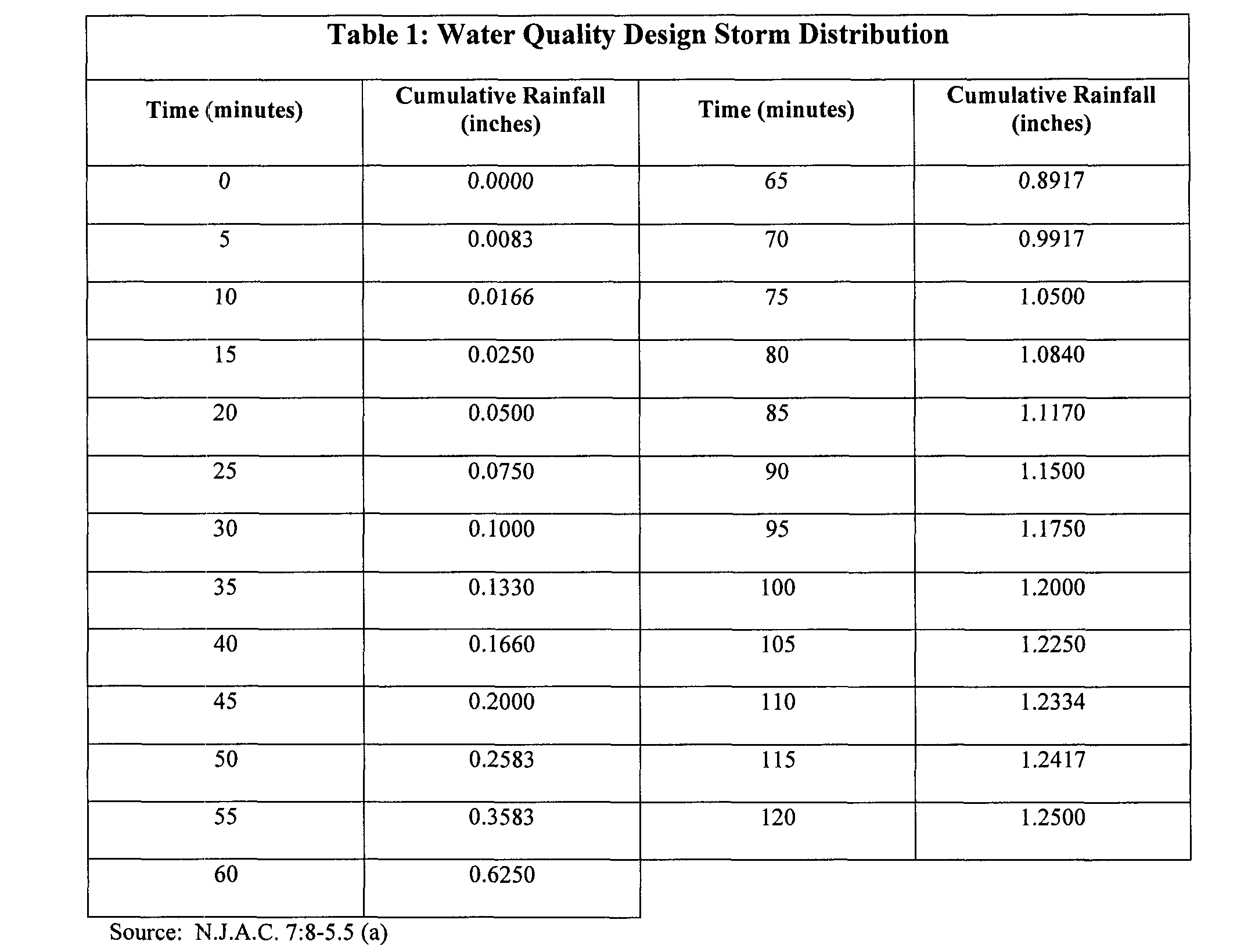
2. The design engineer shall also use the NJDEP Water Quality Design Storm, which is one and one-quarter (1.25) inches of rainfall falling in a nonlinear pattern in two (2) hours. Details of the Water Quality Design Storm are shown in Table 1.�
3. Calculation of runoff volumes, peak rates, and hydrographs for the Water Quality Design Storm may take into account the implementation of nonstructural and structural stormwater management measures.�
4. Total Suspended Solids (TSS) reduction calculations. �
a) If more than one stormwater BMP in series is necessary to achieve the required eighty percent (80%) TSS reduction for a site, the applicant shall utilize the following formula to calculate TSS reduction:�
R.= A + B - (A x B) / 100, where:�
R.= total TSS percent load removal from application of both BMPs;�
A.= the TSS percent removal rate applicable to the first BMP; and�
B.= the TSS percent removal rate applicable to the second BMP. �
b) If there is more than one onsite drainage area, the eighty percent (80%) TSS removal rate shall apply to each drainage area, unless the runoff from the subareas converge on site, in which case the removal rate can be demonstrated through a calculation using a weighted average.�
5. TSS removal rates for stormwater BMPs. �
a) For purposes of TSS reduction calculations, Table 2 presents the presumed removal rates for certain BMPs designed in accordance with the New Jersey BMP Manual. The BMP Manual may be obtained from the address identified in Section 12.A or found on the NJDEP's website at www.njstormwater.org. TSS reduction shall be calculated based on the removal rates for the BMPs in Table 2. �
b) Alternative stormwater management measures, removal rates and methods of calculating removal rates may be used if the design engineer provides documentation demonstrating the capability of these alternative rates and methods to Pemberton Township. Any alternative stormwater management measure, removal rate or method of calculating the removal rate shall be subject to approval by Pemberton Township and a copy shall be provided to the following:�
i. The Division of Watershed Management, New Jersey Department of Environmental Protection, PO Box 418 Trenton, NJ, 086250418; and �
ii. The New Jersey Pinelands Commission, PO Box 7, New Lisbon, NJ, 08064.�

