
This article provides design guidelines, design standards and construction specifications which shall apply to applications for site plan or subdivision approval. Site plans and subdivisions, to the maximum extent practicable, shall be designed to:�
A. be consistent with the Village Master Plan, Official Map and with the zoning regulations, Article X of this chapter;�
�
B. consider County,, regional and State plans for the Village, and to conform to all applicable regulations of the County, State or federal governments, as well as any regional entities having jurisdiction;�
C. minimize negative impacts to the natural and man-made environment, including wetlands, areas prone to flooding, stream corridors, steep slopes, surface and ground water systems, significant stands of vegetation, wildlife, historical structures and sites/ existing structures, neighborhood character and the 'fiscal stability of the' 'Community; and�
D. advance the purposes of this chapter and the Municipal Land Use Law, as applicable.�
A. General. The layout of blocks and lots shall be designed to:�
(1) be compatible with the lot and block patterns established in the neighborhood, as appropriate;�
(2) minimize negative impacts to the natural and man-made environments;�
(3) provide for a well-designed system for circulation and access; and�
(4) provide a suitable amount of land on each lot that will enable appropriate development according to this chapter without undue environmental impact.�
B. Block length. No block shall exceed one thousand (1,000) feet in length, except when a greater length is necessary to implement a conforming dead end street layout as permitted by this chapter.�
C. Block corners at intersections shall be rounded at the property line with a minimum radius of twenty-five (25) feet.�
D. Conformance with zoning. whenever a new lot is formed from a part of any other lot or lots, the assembly or separation shall be effected in such a manner as not to impair any of the requirements of this chapter. No subdivision shall be permitted which results in a change in area, width, or front, side or rear yard that fails to comply in every respect with the required provisions of the district in which it is located.�
E. Lot shape. Lots shall be shaped to enable proper use, maintenance of and access to the lot, and in keeping with the planned future development of the area, as indicated in the Master Plan and zoning regulations. Insofar as is practical, side lot lines shall be at right angles to straight streets and radial to curved streets.�
F. Each lot must front upon an approved street at least fifty (50) feet in width, or such greater width that may be required by the Village master plan, official map or by any other law.�
�
G. Reserve access strips. No subdivision showing reserve strips controlling access to streets shall be approved unless the control and disposal of 'land comprising such strips has been placed in the Village Council under conditions approved by the Board and the Council.�
H. Suitability of lots for development. The Board may, after adequate investigation, withhold approval of any lot which in its opinion is not suitable for its intended use due to factors such as, but not limited to, rock formations, surface or underground mines, flooding, wetlands, soil conditions, presence of hazardous materials, excessive slopes, etc.�
The following standards shall apply for all streets which are within the jurisdiction of the Village of Ridgewood.�
A. General. Streets, driveways, aisles and sidewalks shall be designed to:�
(1) Comply with the proposals in the Village Master Plan and Official Map.�
(2) permit the safe, efficient, and orderly movement of vehicular and pedestrian traffic;�
(3) discourage heavy volumes of through traffic on minor streets and in residential areas;�
(4) provide for anticipated future volumes and speeds of traffic;�
(5) provide for adequate access and movement of emergency and service vehicles, including police and fire-fighting equipment, school buses, street maintenance vehicles'. garbage trucks, delivery vehicles, etc.�
(6) provide access to adjacent properties without unduly interfering with the flow of traffic;�
(7) provide a simple and logical street pattern; and�
(8) provide an attractive streetscape.�
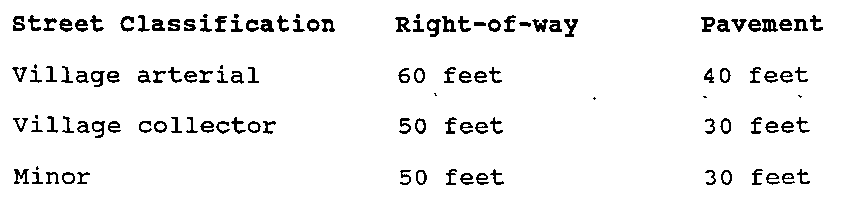
B. Street width. The width of street right-of-way and pavement shall be as set forth below, according to the Master Plan street classifications, unless in a particular situation the Master Plan or Official Map require a greater width, and provided that the Board may require greater width in a particular situation based upon analysis of traffic and street conditions:�
�
(2) Subdivisions which abut existing streets that do not conform to the width standards of this chapter shall dedicate additional width along one (1) or both sides of such street as may be required or permitted by law.�
(3) Half streets. Half streets shall be prohibited except where essential to the reasonable development of the subdivision in conformity with other requirements of this chapter and where the Board finds that it will be practical to require the dedication of the other half of the street when the adjoining property is subdivided. Wherever a half street is adjacent to a tract to be subdivided, the other half the street shall be platted within such tract.�
C. Street grades and grading. Streets shall be graded in accordance with the following standards:�
(1) Minimum grade. All streets shall have a minimum centerline grade of one percent (1%).�
(2) Maximum grade. No street shall have a centerline grade which exceeds ten percent (10%)�
(3) The developer shall be required to grade the full width of the street right-of-way, and to grade abutting property as necessary to comply with the design standards of this chapter for streets. Where required by the Board, the developer shall provide slope-right easements on property abutting the street right-of-way.�
D. Sight easements for horizontal curves. Sight easements shall be provided at horizontal curves when it is determined by the Planning Board and the Village Engineer that same are necessary for proper visibility. The boundaries of the easement shall be determined based upon conditions which exist at the curve.�
E. Street intersections. The following standards shall apply:�
(1) Street intersections shall be as nearly at right angles as possible and in no case shall the angle of intersection be less than sixty degrees (60).�
�
(2) New intersections created with an existing street shall be aligned with any existing or planned streets on the opposite side of the intersecting street and shall minimize jogs and sharp angles.�
(3) Sight easements shall be provided at all intersections, when essential for traffic safety.�
F. Dead end streets. The following standards shall apply to dead end streets:�
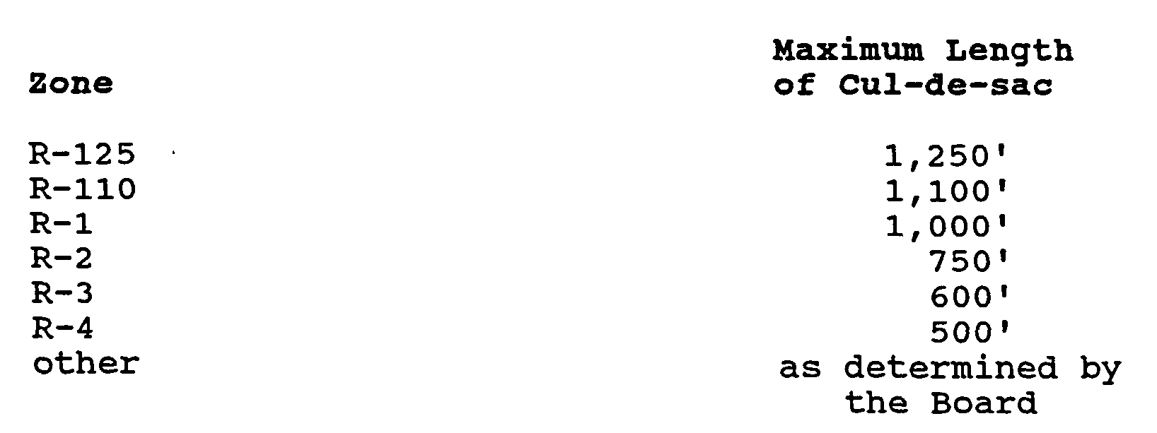
(1) The maximum length of dead end streets shall relate to the district within which the lots fronting on the street are located, in accordance with the following schedule. The length shall be measured along the center line of the street(s) between the extreme dead end of the right-of-way line at the turning circle to the center line of the nearest intersecting through street.�
(2) There shall be a turnaround provided at the end of all dead end streets with a minimum outside curb radius of thirty (30) feet, and a minimum right-of-way radius of forty (40) feet. Whenever possible, the turnaround shall be tangent to the right side of the street as one approaches the turnaround.�
(3) If a dead end street is of a temporary nature, a turnaround shall be provided in accordance with the standards for permanent turnarounds. Provision shall be made for the future extension of the street and the reversion of excess right-of-way to abutting property owners. Removal of the temporary turnaround and installation of permanent improvements, including but not limited to pavement, sidewalks, curbs, topsoil, shade trees, driveway aprons, etc. shall be at the developer's sole expense.�
G. Street pavement. All streets shall be paved in accordance with the street specifications for the Village.�
H. Private streets. Any private street proposed for any development shall follow the same standards required for public streets.�
Streets, parking areas, loading areas, driveways for non-residential and multi-family residential developments, and other paved areas required by the Board shall be bounded by curbs constructed according to the Village street curb standards.�
Sidewalks shall be constructed in accordance with the following standards:�
A. Sidewalks shall be installed on both sides of streets.�
B. Sidewalks shall be at least four (4) feet wide, except where site conditions warrant a greater width.�
C. Provisions are to be made for access by disabled persons, particularly as they relate to entrance ways and ramps, both within new and remodeled buildings and structures.�
Flared driveway aprons shall be provided between the street pavement and the sidewalk, or, when no sidewalk is required, between the street pavement and the right-of-way line, in accordance with the requirements of the Director of Public Works.�
�
A. Purpose.�
It is the purpose of this section to establish minimum stormwater management requirements and controls for "major development" and "minor development" as defined in this section. The standards are intended to:�
�
(1) Minimize the impact of stormwater runoff on water quality and water quantity in receiving water bodies;�
(2) Maintain groundwater recharge;�
(3) Minimize the potential for erosion and sedimentation;�
(4) Prevent degradation of wildlife habitat, including but not limited to stream, swamp, lake and pond habitats;�
(5) Consider the impact of the proposed development on the total watershed area;�
(6) Provide for proper maintenance and repair of stormwater facilities;�
(7) Provide for proper security of stormwater facilities and prevent undue hazards; and�
(8) Ensure that stormwater facilities are esthetically pleasing.�
(9) Require the retrofitting of existing storm drain inlets which are in direct contact with repaving, repairing, reconstruction, or resurfacing or alterations of facilities on private property, to prevent the discharge of solids and floatables (such as plastic bottles, cans, food wrappers and other litter) to the municipal separate storm sewer system(s) operated by the Village of Ridgewood so as to protect public health, safety and welfare.�
**Webmasters Note: The previous subsection has been added as per Ordinance No. 3223.�
B. Applicability, scope, exemptions and waivers.�
This section shall apply to all aspects of development, municipal or private, that are not pre-empted by the Residential Site Improvement Standards at N.J.A.C. 5:21 or by other law. In addition, the following provisions shall govern the application of this section:�
(1) Minimum requirements. In their interpretation and application, the provisions of this section shall be held to be the minimum requirements for the promotion of the public health, safety, and general welfare.�
(2) Other approvals. Development approvals issued pursuant to this section do not relieve the applicant of the responsibility to secure required permits or approvals for activities regulated by any other applicable code, rule, act, or ordinance.�
(3) Effect upon other regulations. This section is not intended to interfere with, abrogate, or annul any other ordinances, rule or regulation, statute, or other provision of law except that, where any provision of this section imposes restrictions different from those imposed by any other ordinance, rule or regulation, or other provision of law, the more restrictive provisions or higher standards shall control.�
�
(4) Exemption in case of regional plan. The standards for major development do not apply to the extent that alternative design and performance standards are applicable under a regional stormwater management plan or Water Quality Management Plan adopted in accordance with Department rules.�
(5) Exemption for certain linear developments. The following linear development projects are exempt from the groundwater recharge, stormwater runoff quantity, and stormwater runoff quality requirements of
(a) The construction of an underground utility line provided that the disturbed areas are revegetated upon completion;�
(b) The construction of an aboveground utility line provided that the existing conditions are maintained to the maximum extent practicable;�
(c) The construction of a public pedestrian access, such as a sidewalk or trail with a maximum width of 14 feet, provided that the access is made of permeable material.�
(6) Agricultural developments.�
Any application for a new agricultural development that meets the definition of major development in
(7) Waivers for widening of certain transportation improvements.�
A.waiver from strict compliance from the groundwater recharge, stormwater runoff quantity, and stormwater runoff quality requirements of
(a) The applicant demonstrates that there is a public need for the project that cannot be accomplished by any other means;�
(b) The applicant demonstrates through an alternatives analysis, that through the use of nonstructural and structural stormwater management strategies and measures, the option selected complies with the requirements of
(c) The applicant demonstrates that, in order to meet the requirements of
(d) The applicant demonstrates that it does not own or have other rights to areas, including the potential to obtain through condemnation lands not falling under (7)(c) above within the upstream drainage area of the receiving stream, that would provide additional opportunities to mitigate the requirements of
(8) Exceptions; required mitigation.�
The municipal reviewing agency may grant an exception from the design and performance standards set forth in
C. Definitions.�
Unless specifically defined below, words or phrases used in this section shall be interpreted so as to give them the meaning they have in common usage and to give this section its most reasonable application. The definitions below are the same as or based on the corresponding definitions in the Stormwater Management Rules at N.J.A.C. 7:8-1.2.�
" BMP " or "Best Management Practice"�
�
�
" COUNTY REVIEW AGENCY " means an agency designated by the County Board of Chosen Freeholders to review municipal stormwater management plans and implementing ordinance(s). The county review agency may either be:�
A.county planning agency; or�
A.county water resource association created under N.J.S.A 58:16A-55.5, if the ordinance or resolution delegates authority to approve, conditionally approve, or disapprove municipal stormwater management plans and implementing ordinances.�
" DEPARTMENT " means the New Jersey Department of Environmental Protection.�
�
" DESIGN ENGINEER " means a person professionally qualified and duly licensed in New Jersey to perform engineering services that may include, but not necessarily be limited to, development of project requirements, creation and development of project design and preparation of drawings and specifications.�
" DEVELOPMENT " means the division of a parcel of land into two or more parcels, the construction, reconstruction, conversion, structural alteration, relocation or enlargement of any building or structure, any mining excavation or landfill, and any use or change in the use of any building or other structure, or land or extension of use of land, by any person, for which permission is required under the Municipal Land Use Law, N.J.S.A. 40:55D-1 et seq. In the case of development of agricultural lands, development means: any activity that requires a State permit; any activity reviewed by the County Agricultural Board (CAB) and the State Agricultural Development Committee (SADC), and municipal review of any activity not exempted by the Right to Farm Act, N.J.S.A 4:1 C-1 et seq.�
" DRAINAGE AREA " means a geographic area within which stormwater, sediments, or dissolved materials drain to a particular receiving water body or to a particular point along a receiving water body.�
" ENVIRONMENTALLY CRITICAL AREAS " means an area or feature which is of significant environmental value, including but not limited to: stream corridors; natural heritage priority sites; habitat of endangered or threatened species; large areas of contiguous open space or upland forest; steep slopes; and well head protection and groundwater recharge areas. Habitats of endangered or threatened species are identified using the Department's Landscape Project as approved by the Department's Endangered and Nongame Species Program.�
" EROSION " means the detachment and movement of soil or rock fragments by water, wind, ice or gravity.�
" IMPERVIOUS SURFACE " means a surface that has been covered with a layer of material so that it is highly resistant to infiltration by water.�
" INFILTRATION " is the process by which water seeps into the soil from precipitation.�
�
" MAJOR DEVELOPMENT " means any development that provides for ultimately disturbing one or more acres of land. Disturbance for the purpose of this rule is the placement of impervious surface or exposure and/or movement of soil or bedrock or clearing, cutting, or removing of vegetation.�
" MINOR DEVELOPMENT " means any development other than major development.�
MUNICIPAL SEPARATE STORM SEWER SYSTEM (MS4) A conveyance or system of conveyance, including roads with drainage systems, municipal streets, catch basins, curbs, gutters, ditches, manmade channels, or storm drains, that is owned or operated by the Village of Ridgewood or other public body, and is designed and used for collecting and conveying stormwater.�
**Webmasters Note: The previous definition has been added as per Ordinance No. 3223.�
" MUNICIPALITY " means any city, borough, town, township, or village.�
�
" NUTRIENT " means a chemical element or compound, such as nitrogen or phosphorus, which is essential to and promotes the development of organisms.�
" PERSON " means any individual, corporation, company, partnership, firm, association, Village of Ridgewood, or political subdivision of this State subject to municipal jurisdiction pursuant to the Municipal Land Use Law, N.J.S.A. 40:55D-1 et seq.�
" POLLUTANT " means any dredged spoil, solid waste, incinerator residue, filter backwash, sewage, garbage, refuse, oil, grease, sewage sludge, munitions, chemical wastes, biological materials, medical wastes, radioactive substance (except those regulated under the Atomic Energy Act of 1954, as amended (42 U.S.C. 2011 et seq.), thermal waste, wrecked or discarded equipment, rock, sand, cellar dirt, industrial, municipal, agricultural, and construction waste or runoff, or other residue discharged directly or indirectly to the land, ground waters or surface waters of the State, or to a domestic treatment works. "Pollutant" includes both hazardous and nonhazardous pollutants.�
" RECHARGE " means the amount of water from precipitation that infiltrates into the ground and is not evapotranspired.�
" SEDIMENT " means solid material, mineral or organic, that is in suspension, is being transported, or has been moved from its site of origin by air, water or gravity as a product of erosion.�
" SITE " means the lot or lots upon which a development is to occur or has occurred.�
�
" SOIL " means all unconsolidated mineral and organic material of any origin.�
�
STORM DRAIN INLET An opening in a storm drain used to collect stormwater runoff and includes, but is not limited to, a grate inlet, curb opening inlet, slotted inlet and combination inlet.�
**Webmasters Note: The previous definition has been added as per Ordinance No. 3223.�
" STORMWATER " means water resulting from precipitation (including rain and snow) that runs off the land's surface, is transmitted to the subsurface, or is captured by separate storm sewers or other sewage or drainage facilities, or; conveyed by snow removal equipment.�
�
" STORMWATER RUNOFF " means water flow on the surface of the ground or in storm sewers, resulting from precipitation.�
" STORMWATER MANAGEMENT BASIN " means an excavation or embankment and related areas designed to retain stormwater runoff. A stormwater management basin may either be normally dry (that is, a detention basin or infiltration basin), retain water in a permanent pool (a retention basin), or be planted mainly with wetland vegetation (most constructed stormwater wetlands).�
" STORMWATER MANAGEMENT MEASURE " means any structural or nonstructural strategy, practice, technology, process, program, or other method intended to control or reduce stormwater runoff and associated pollutants, or to induce or control the infiltration or groundwater recharge of stormwater or to eliminate illicit or illegal non-stormwater discharges into stormwater conveyances.�
WATERS OF THE STATE The ocean and its estuaries, all springs, streams and bodies of surface water or ground water, whether natural or artificial, within the boundaries of the State of New Jersey or subject to its jurisdiction.�
**Webmasters Note: The previous definition has been amended as per Ordinance No. 3223.�
" WETLANDS" OR "WETLAND " means an area that is inundated or saturated by surface water or ground water at a frequency and duration sufficient to support, and that under normal circumstances does support, a prevalence of vegetation typically adapted for life in saturated soil conditions, commonly. known as hydrophytic vegetation.�
�
D. Requirements for major development.�
Major development, as defined by this section, shall be subject to the following requirements:�
(1) General.�
(a) All major development shall comply with the design and performance standards for erosion control, groundwater recharge, stormwater runoff quantity control, maintenance and other requirements contained in this subsection.�
(b) In addition to all other applicable requirements, major development that results in an additional acre of total impervious surface on a development site shall comply with the standards for stormwater runoff quality control.�
(c) To the maximum extent practicable, these standards shall be met by incorporating nonstructural stormwater management strategies into the design. Nonstructural strategies include both environmentally sensitive site design and source controls that prevent pollutants from being placed on the site or from being exposed to stormwater. If these strategies alone are not sufficient to meet these standards, structural stormwater management measures necessary to meet these standards shall be incorporated into the design.�
(d) Structural BMPs should be integrated with nonstructural stormwater management strategies and proper maintenance plans.�
(e) Source control plans should be developed based upon physical site conditions and the origin, nature, and the anticipated quantity or amount of potential pollutants.�
(f) Multiple stormwater management BMPs may be necessary to achieve the established performance standards for water quality, quantity, and groundwater recharge.�
(g) Development applications and approvals shall incorporate a maintenance plan for the stormwater management measures incorporated into the design of the development in accordance with
(h) Stormwater management measures shall avoid adverse impacts of concentrated flow on habitat for threatened and endangered species as documented in the Department' Landscape Project or Natural Heritage Database established under N.J.S.A. 13:1 B-15.147 through 15.150, particularly Helonias bullata (swamp pink) and/or Clemmys muhlnebergi bog turtle).�
(2) Nonstructural stormwater management strategies�
(a) Strategy prioritization. To the maximum extent practicable, the standards in
(b) Strategy objectives. Nonstructural stormwater management strategies incorporated into site design shall:�
[1] Protect areas that provide water quality benefits or areas particularly susceptible to erosion and sediment loss;�
[2] Minimize impervious surfaces and break up or disconnect the flow of runoff over impervious surfaces;�
[3] Maximize the protection of natural drainage features and vegetation;�
[4] Minimize the decrease in the "time of concentration" from preconstruction to post construction. "Time of concentration" is defined as the time it takes for runoff to travel from the hydraulically most distant point of the watershed to the point of interest within a watershed;�
[5] Minimize land disturbance including clearing and grading;�
[6] Minimize soil compaction;�
[7] Provide low-maintenance landscaping that encourages retention and planting of native vegetation and minimizes the use of lawns, fertilizers and pesticides;�
[8] Provide vegetated open-channel conveyance systems discharging into and through stable vegetated areas;�
[9] Provide other source controls to prevent or minimize the use or exposure of pollutants at the site, in order to prevent or minimize the release of those pollutants into stormwater runoff. Such source controls include, but are not limited to:�
[a] Site design features that help to prevent accumulation of trash and debris in drainage systems, including features that satisfy
[b] Site design features that help to prevent discharge of trash and debris from drainage systems;�
[c] Site design features that help to prevent and/or contain spills or other harmful accumulations of pollutants at industrial or commercial developments;�
[d] When establishing vegetation after land disturbance, applying fertilizer in accordance with the requirements established under the Soil Erosion and Sediment Control Act, N.J.S.A. 4:24-39 et seq., and implementing rules.�
(c) Perpetual maintenance.�
Any land area used as a nonstructural stormwater management measure to meet the performance standards in
(d) Technical guidance.�
Guidance for nonstructural stormwater management strategies is available in the New Jersey Stormwater Best Management Practices Manual. The BMP Manual may be obtained from the address identified in Subsection G below, or found on the Department's website at www.njstormwater.org.�
(3) Erosion control standards.�
�
The minimum design and performance standards for erosion control are those established under the Soil Erosion and Sediment Control Act, N.J.S.A. 4:24-39 et seq. and implementing rules.�
(4) Groundwater recharge standards.�
The minimum design and performance standards for groundwater recharge are as follows:�
(a) Recharge volume. The design engineer' shall, using the assumptions and factors for stormwater runoff and groundwater recharge calculations at
[1] Demonstrate through hydrologic and hydraulic analysis that the site and its stormwater management measures maintain 100 percent of the average annual pre-construction groundwater recharge volume for the site; or�
[2] Demonstrate through hydrologic and hydraulic analysis that the increase of stormwater runoff volume from pre-construction to post-construction for the 2-year storm is infiltrated.�
(b) Calculations.�
Groundwater recharge may be calculated in accordance with the New Jersey Geological Survey Report GSR-32, A Method for Evaluating Ground-Water Recharge Areas in New Jersey, incorporated herein by reference as amended and supplemented. Information regarding the methodology is available from the New Jersey Stormwater Best Management Practices Manual; at http://www.state.nj.us/dep/njgs/; or at New Jersey Geological Survey, 29 Arctic Parkway, P.O. Box 427 Trenton, New Jersey 08625-0427; (609) 984-6587.�
(c) Prohibited recharge. The following types of stormwater shall not be recharged:�
[1] Stormwater from areas of high pollutant loading. High pollutant loading areas are areas in industrial and commercial developments where solvents and/or petroleum products are loaded/unloaded, stored, or applied, areas where pesticides are loaded/unloaded or stored; areas where hazardous materials are expected to be present in greater than "reportable quantities" as defined by the United States Environmental Protection Agency (EPA) at 40 CFR 302.4; areas where recharge would be inconsistent with Department approved remedial action work plan or landfill closure plan and areas with high risks for spills of toxic materials, such as gas stations and vehicle maintenance facilities; and�
[2] Industrial stormwater exposed to "source material." "Source material" means any material(s) or machinery, located at an industrial facility that is directly or indirectly related to process, manufacturing or other industrial activities, which could be a source of pollutants in any industrial stormwater discharge to groundwater. Source materials include, but are not limited to, raw materials; intermediate products; final products; waste materials; by-products; industrial machinery and fuels, and lubricants, solvents, and detergents that are related to process, manufacturing, or other industrial activities that are exposed to stormwater.�
(d) The design engineer shall assess the hydraulic impact on the groundwater table and design the site so as to avoid adverse hydraulic impacts. Potential adverse hydraulic impacts include, but are not limited to, exacerbating a naturally or seasonally high water table so as to cause surficial ponding, flooding of basements, or interference with the proper operation of subsurface sewage disposal systems and other subsurface structures in the vicinity or down gradient of the groundwater recharge area.�
(5) Runoff quantity standards.�
(a) Pre-construction runoff rates to be maintained. In order to control stormwater runoff quantity impacts, the design engineer shall, using the assumptions and factors for stormwater runoff calculations at
[1] Demonstrate through hydrologic and hydraulic analysis that for stormwater leaving the site, post-construction runoff hydrographs for the 2, 10, and 100-year storm events do not exceed, at any point in time, the pre-construction runoff hydrographs for the same storm events;�
[2] Demonstrate through hydrologic and hydraulic analysis that there is no increase, as compared to the pre-construction condition, in the peak runoff rates of stormwater leaving the site for the 2, 10, and 100-year storm events and that the increased volume or change in timing of stormwater runoff will not increase flood damage at or downstream of the site. This analysis shall include the analysis of impacts of existing land uses and projected land uses assuming full development under existing zoning and land use ordinances in, the drainage area; or�
[3] Design stormwater management measures so that the postconstruction peak runoff rates for the 2, 10 and 100 year storm events are 50, 75 and 80 percent, respectively, of the preconstruction peak runoff rates. The percentages apply only to the post-construction stormwater runoff that is attributable to the portion of the site on which the proposed development or project is to be constructed. The percentages shall not be applied to post-construction stormwater runoff into tidal flood hazard areas if the increased volume of stormwater runoff will not increase flood damages below the point of discharge.�
(b) Calculation methodology. Stormwater runoff shall be calculated in accordance with the following:�
[1] The design engineer shall calculate runoff using one of the following methods:�
[a] The USDA Natural Resources Conservation Service (NRCS) methodology, including the NRCS Runoff Equation and Dimensionless Unit Hydrograph, as described in the NRCS National Engineering Handbook Section 4 - Hydrology and Technical Release 55 - Urban Hydrology for Small Watersheds; or�
�
[b] The Rational Method for peak flow and the Modified Rational Method for hydrograph computations.�
�
[2] For the purpose of calculating runoff coefficients and groundwater recharge, there is a presumption that the preconstruction condition of a site or portion thereof is a wooded land use with good hydrologic condition. The term "runoff coefficient" applies to both the NRCS methodology at
[3] In computing pre-construction stormwater runoff, the design engineer shall account for all significant land features and structures, such as ponds, wetlands, depressions, hedgerows, or culverts that may reduce pre-construction stormwater runoff rates and volumes.�
[4] In computing stormwater runoff from all design storms, the design engineer shall consider the relative stormwater runoff rates and/or volumes of pervious and impervious surfaces separately to accurately compute the rates and volume of stormwater runoff from the site. To calculate runoff from unconnected impervious cover, urban impervious area modifications as described in the NRCS Technical Release 55 Urban Hydrology for Small Watersheds and other methods may be employed.�
[5] If the invert of the outlet structure of a stormwater management measure is below the flood hazard design flood elevation as defined at N.J.A.C. 7:13, the design engineer shall take into account the effects of tailwater in the design of structural stormwater management measures. The Village Engineer may also require that the outfall pipe be equipped with a backflow prevention measure such as tide gate.�
(6) Runoff quality standards.�
Stormwater management measures shall only be required for water quality control if an additional 1/4 acre (10,890 square feet) or more of impervious surface is being proposed on a development site. Such measures shall comply with the following requirements:�
(a) Suspended solids. Stormwater management measures shall be designed to reduce the post-construction load of total suspended solids (TSS) in stormwater runoff by 80 percent of the anticipated load from the developed site, expressed as an annual average. The requirement to reduce TSS does not apply to any stormwater runoff in a discharge regulated under a numeric effluent limitation for TSS imposed under the New Jersey Pollution Discharge Elimination System (NJPDES) rules, N.J.A.C. 7:14A, or in a discharge specifically exempt under a NJPDES permit from this requirement.�
�
[1] The water quality design storm is 1.25 inches of rainfall in two hours. Water quality calculations shall take into account the distribution of rain from the water quality design storm, as reflected in Table 1. The calculation of the volume of runoff may take into account the implementation of non-structural and structural stormwater management measures.�

