
[Amended by Ord. No. 248; Ord. No. 254; Ord. No. 292; Ord. No. 318]�
A. Districts Established. For purposes of this Chapter, the Borough of Alpine is divided into the following districts:�
R-R District�
R-A District�
R-AA District�
R-1 District�
R-2 District�
R-2A District�
R-2B District�
R-2C District�
R-3 District�
R-4 District�
P.District�
B.(Buffer) District�
COAH-1�
COAH-2�
**Webmasters Note: The previous subsection has been amended as per Ordinance No. 632.�
B. Boundaries The boundaries of the above created districts are hereby established as shown on the Zoning Map dated April 23, 1979, and as amended by Ordinance No 300, dated May 19, 1980, and as amended April 26, 1982, and as amended by Ordinance No 434, dated January 22, 1990, which Map is hereby made a part of this chapter [Amended by Ord. No. 434; Ord. No. 450; Ord. No. 473; Ord. No. 513]�
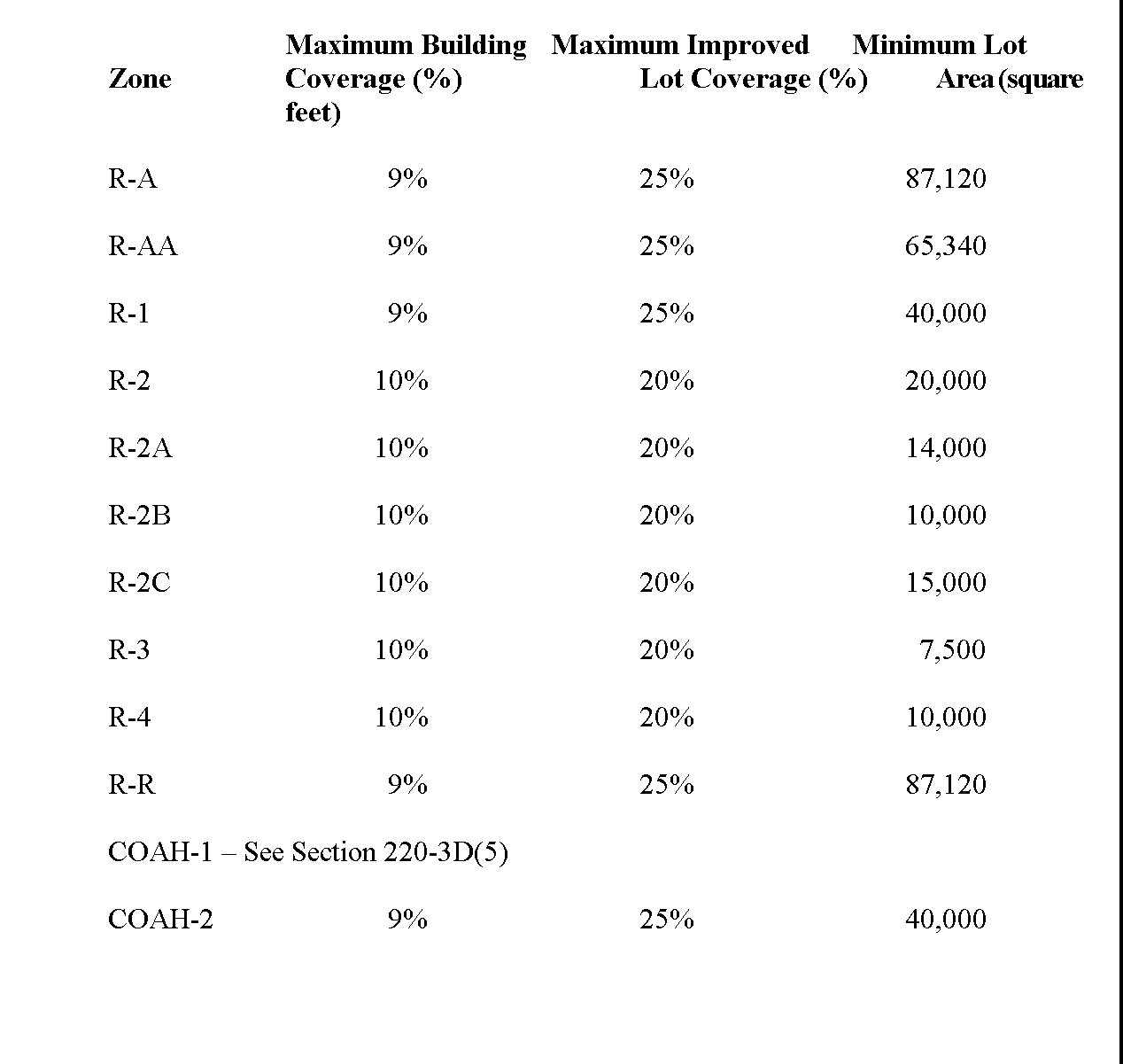
C. Limiting Schedule�
D. Limitation of coverage on land [Amended 10-25-2002 by Ord. No. 578; 5-23-2001 by Ord. No. 567]�
(1) All properties located in the Borough shall be subject to the following maximum building coverage and maximum improved lot coverage:�
**Webmasters Note: The previous subsection has been amended as per Ordinance No. 632.�
(2) Building coverage shall mean that portion of a lot which is occupied by the principal building�
(3) Improved lot coverage shall mean the part of the site that is covered by buildings, parking areas, driveways, pools, walkways or paved ancillary surfaces such as decks, patios, tennis courts and similar improvements and any other impervious surface�
(4) Impervious coverage shall mean any surface that has been compacted or covered with a layer of material so that it is highly resistant to infiltration by water�
**Webmasters Note: Subsection (5) has been deleted and the following subsection renumbered as per Ordinance No. 609.�
�
(5) In the COAH-1 District, the minimum distance between buildings shall be 30 feet and the minimum building setback to internal streets and driveways shall be 18 feet In the COAH-1 District the maximum improved lot coverage may be 30% of the total land owned by such person or corporation erecting buildings in said District In the COAH-2 District the maximum improved lot coverage shall comply with the limitation of coverage on land requirements set forth in Subsection D�
E. Steep slopes [Added 5-28-1997 by Ord. No. 532]�
(1) Statement of purpose�
(a) It is the express purpose of this subsection to provide for special qualitative and quantitative development controls for all lands located within the Borough of Alpine which have present within their boundaries topographical conditions hereinafter defined as "steep slopes " These special development controls are provided in recognition of the potentially negative impacts of construction in steep slope areas in the form of erosion, siltation, excessive removal of vegetation and soil, flooding, soil slippage, water runoff and destruction of unique land forms and predominant views It is further the purpose of this subsection to encourage good land use planning and design and to maximize the best use of the natural terrain and to maintain the critical land forms intact to the extent reasonably possible and desirable�
(b) Effective and reasonable application of these regulations will protect the health, safety, and welfare of the citizens of the Borough of Alpine, and the following purposes of the Municipal Land Use Law are advanced (N.J.S.A 40 5513-2) by these regulations�
To secure safety from fire, flood, panic and other natural and man-made disasters,�
To provide sufficient space in appropriate locations for a variety of agricultural, residential, recreational, commercial and industrial uses and open space, both public and private, according to their respective environmental requirements in order to meet the needs of all New Jersey citizens,�
To promote a desirable visual environment through creative development techniques and good civic design and arrangements,�
To promote the conservation of historic sites and districts and districts open space, energy resources and valuable natural resources in the state and to prevent urban sprawl and degradation of the environment through improper use of land,�
(c) The 1994 Borough of Alpine Master Plan Update recommended identification of steep slope areas and the Statement of Objectives and Principles contained the following�
To encourage good design, existing natural settings and preservation of trees which will be compatible with surrounding properties and with the high quality of residences in Alpine�
Furthermore, the 2002 Borough of Alpine Master Plan reiterated the Borough's concern with protection of environmentally sensitive features by including the following goal and associated policy statement:�
Goal: To ensure that any prospective development is responsive to the borough's environmental features, and is designed to preserve the community's physical characteristics.�
Policy Statement: The Borough of Alpine seeks to limit development to that which is sensitive to the community's particular physical characteristics, and preserves the borough's sensitive environmental features. In particular, the borough seeks to limit development to that which preserves steeply sloped areas (defined to include any slope of minimally fifteen percent grade), wetlands, and flood plains, and retains existing vegetation (particularly trees of a caliper of six inches or more and clusters of trees which may be of lesser caliper if determined appropriate). With respect to these areas of concerns: (1) The borough should require restitution for all illegally removed trees. (2) Borough policy seeks to encourage the conservation of sites with particular environmental sensitivity, especially those properties along Route 9W. (3) It is specifically noted with respect to steep slopes that slope zoning regulations should be applied to each individual building lot in a development application. (4) The borough takes cognizance of the fact that there are numerous sites in the municipality that are typified by extensive environmentally sensitive features and therefore may not be able to accommodate its full zoned development potential.�
**Webmasters Note: The previous subsection has been amended as per Ordinance No. 609.�
(d) This subsection is further promulgated to provide a functional land use design and control mechanism which will augment the basic land use controls of this chapter and the administrative implementing devices contained within the Borough's site plan and subdivision ordinance 3�
(2) Applicability The requirements, guidelines, and controls promulgated under this subsection shall be applicable to all properties within all zone districts situated in the Borough of Alpine in their existing physical state or condition as of the date of the passage of this subsection Said applicability shall apply only to new construction where said properties fall within 15% or greater slope area, except as provided for in Subsection E(5) This subsection shall further apply to building reconstruction where over 50% of any structure on a property or parcel of land is destroyed by fire or other natural occurrence or as a result of redevelopment and the entire footprint of said structure falls within a 15% or greater slope area�
(3) Definitions As used in this subsection, the following terms shall have the meanings indicated�
**Webmasters Note: The definition for Adjusted Density has been deleted as per Ordinance No. 609.�
DISTURBANCE CONTROL CRITERIA - Those criteria set forth in Subsection E(5) of this section�
**Webmasters Note: The previous definition has been amended as per Ordinance No. 609.�
DISTURBANCE - Any physical activity which results in removal of vegetation, modification of topography by cutting or filling, stripping of topsoil, and/or placing of physical structures or improvements thereon�
GRADE - The contour or surface of the ground�
�
(a) ORIGINAL GRADE - The natural contour or surface of the ground before any disturbance�
(b) FINISHED GRADE - The contour or surface of the ground at the completion of a project after any disturbance�
GRADING - Any disturbance of the original grade by stripping, cutting, filling, stockpiling, or any combination thereof�
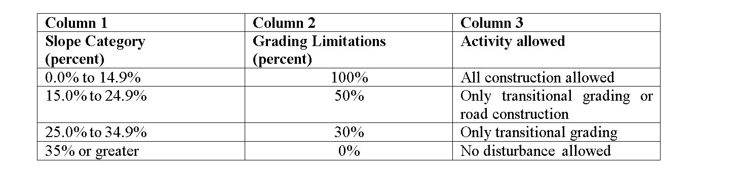
GRADING LIMITATIONS - The extent of the disturbance allowed in Subsection E(6), Construction control limitation, Column 2, of this section�
**Webmasters Note: The definition for Permitted Density has been deleted as per Ordinance No. 609.�
SLOPE MEASUREMENT CRITERIA - The following slope measurement criteria shall serve as the basic means of identifying and categorizing steep slopes as further regulated under this subsection�
(a) Vertical measurement Vertical measurement shall be determined utilizing two foot contours as documented and determined by on-site survey or the use of photogrammetric aerial topography�
(b) Horizontal measurement Horizontal measurement shall be determined by use of an appropriate scale as required by Borough site plan or subdivision ordinance measuring a minimum horizontal section 30 feet in length�
(c) Application of vertical and horizontal measurements The vertical and horizontal measurements are utilized to determine the slope by measuring the vertical rise on the basis of two-foot contours in a thirty-foot horizontal length�
STEEP SLOPE - Includes slopes in excess of 15% in gradient as measured and documented in accordance with the "slope measurement criteria" definition�
TRANSITIONAL GRADING - The disturbance in that area of land between the original grade and the finished grade to accommodate roads, parking areas, structures and other like improvements�
�
(4) Application procedure For all subdivision plats, site plans and applications for building permits, the following information shall be submitted to the Borough Engineer for review�
�
(a) Topography map showing existing contours at two-foot intervals�
(b) Areas clearly identified showing the following slopes as measured in a thirty-foot horizontal length pursuant to the definition of "slope measurement criteria" in Subsection E(3)�
35% or greater�
25.0% to 34.9%�
15.0% to 24.9%�
0.0% to 14. 9%�
(c) Calculations, in square footage and areas, of amount of area in the various slope categories listed above�
**Webmasters Note: Subsection (5) has been deleted and the following subsections renumbered as per Ordinance No. 609.�
(5) Disturbance Control Criteria. To meet the purposes, goals and standards set forth in this subsection only the following disturbance and physical development activities shall be permitted:�
**Webmasters Note: The previous subsection has been added as per Ordinance No. 609.�
(6) Exemptions All existing developed structures shall be exempt from this subsection, except as provided for in Subsection E(2)�
(7) Soil moving Nothing herein shall be construed to affect the provisions of Chapter 185, Soil Fill and Soil Removal�
(8) Planning Board jurisdiction and variances Nothing in this subsection shall be construed to limit the jurisdiction of the Planning Board or Zoning Board of Adjustment over site plan approval or to grant variances or waivers in accordance with the Municipal Land Use Law, as amended�
[Amended by Ord. No. 378]�
A. Continuation of use Any lawful nonconforming use, or structure containing a lawful nonconforming use, existing on August 25, 1986, may be continued upon the lot or in the structure so occupied, and any such structure may be restored or repaired in the event of partial destruction�
B. Expansion or change of use A nonconforming use on the premises in existence on August 25, 1986, shall not be expanded, increased or enlarged and shall not be permitted to be changed to any use other than a conforming use�
C. Maintenance of structure Normal maintenance of a nonconforming structure, or of a structure containing a nonconforming use, is permitted, including necessary repairs and incidental alterations, provided that such repairs and alterations shall not increase the degree of nonconformity of the structure nor extend the nonconforming use�
D. Alteration of structure A structure containing a nonconforming use may not be reconstructed or structurally altered unless such structure is changed to be conforming�
E. Reconstruction of structure A building permit for the reconstruction of any nonconforming use must be applied for within six months from the time of partial destruction�
F. Cessation of use In the event there is a cessation of operation of any nonconforming use, an intent to terminate is manifested or the nonconforming use has been discontinued for a period of one year, the same shall be deemed to be an abandonment of such nonconforming use Any subsequent exercise of abandoned nonconforming use shall be deemed a violation of the terms of this section 6�
A. [Amended by Ord. No. 249; Ord. No. 254; Ord. No. 292] Permitted uses Within the RA, R-AA, R-1, R-2, R-2A, R-2B, R-3 or R-4 Zones, no building or lot shall be used for any purpose except the following�
(1) A one-family detached dwelling with no boarders or roomers�
(2) A public park, public playground, public athletic field, public museum, public library, firehouse or municipal building, in each case owned or operated by the Borough�
(3) Agricultural and horticultural land uses and the buildings incidental to residence, provided that no accessory buildings or runs for poultry or animals, no outdoor storage of fertilizer and manure and no greenhouse heating plant be within 30 feet of any lot line�
B. Accessory uses [Amended by Ord. No. 252]�
(1) Private garage, emergency shelters, customary recreational facilities, including family swimming pool, tennis courts, paddle courts, subject to § 220-13�
(2) Recreational equipment shall be deemed to be such as does not have any structure and being movable�
(3) Other accessory uses�
�
(4) No residence building shall be rented to or occupied by more than two unrelated persons�
C. Drainage control in the R-A, R-AA, R-1 and R-R Zone Districts Because of the slope and rocky soil condition of the land in the R-A, R-AA, R-1 and R-R Zone Districts, and the liability caused thereby of serious flooding, erosion and sedimentation when new buildings are constructed unless special remedial and protective measures are taken, the submission of a drainage plan and plan for control of erosion and sedimentation and a stormwater management system prepared by a design engineer in accordance with the provisions of N J A C 5 21-7, et seq shall be submitted to the Building Inspector with each application for a building permit for a new construction or addition to existing buildings Such plans shall be reviewed by the Borough Engineer and approved only if adequate provisions are found to be made to accommodate a fifty-year design storm [Amended by Ord. No. 272; Ord. No. 278; 4-25-2001 by Ord. No. 587]�
D. Illumination of tennis courts, basketball courts, platform tennis courts and similar areas of recreation [Amended by Ord. No. 276; Ord. No. 408]�
(1) Lighting standards Lighting fixtures for tennis courts and similar areas of recreation must comply with the following regulations�
(a) Height Light standards inclusive of fixtures shall not exceed 25 feet in height above ground level, nor shall any light fixture be installed more than 25 feet above ground level�
(b) Glare�
[1] "Glare" is the sensation produced by brightness within the visual field that is sufficiently greater than the illumination to which the eyes are adapted to cause annoyance, discomfort or loss in visual performance and visibility "Direct glare" is a glare resulting from insufficiently shielded light sources in the field of view No direct glare shall be permitted If required, the lights shall be shielded by louvers, baffles or visors to restrict the maximum apex angle of the cone of illumination to 135 The upper apex of the apex angle shall not exceed 75 from the horizontal Shielding on one side of the light may also be required�
[2] At any point on any adjoining property the total direct and indirect glare measured at a height of three feet above ground level shall not exceed 0 2 of a footcandle over the combined illumination of all other lighting on the premises and lighting from any natural light source The readings shall be made with a direct reading, portable light meter held toward the source of light which meter shall have been tested and calibrated by an independent commercial photometric laboratory or the manufacturer of such meters within one year prior to the date of use as attested by a certificate issued by such laboratory or manufacturer�
(c) Setback Lighting fixtures must comply with the setback requirements for accessory buildings, as set forth in § 220-13F�
(d) Hours Lighting of a tennis court, basketball court, platform tennis court or similar area of recreation is prohibited between 10 00 p in and 7 00 a in the next day, local time, except on Friday and Saturday when such lighting shall be prohibited from 11 00 p in to 7 00 a in the next day, local time�
(2) Application requirements�
(a) To whom made All applications for lighting of tennis courts, basketball courts, platform tennis courts and similar areas of recreation must be made to the Zoning Officer�
(b) Fees and deposits Any person making an application shall pay a nonreturnable fee of $200 accompanying such application In addition, the application shall be accompanied by a deposit of $2,000 to cover the cost of review services provided by the Borough Engineer, planning consultant, Borough Attorney, Zoning Board of Adjustment attorney and other borough personnel, the publication of notices and other required expenses The Borough Clerk shall place the deposit in a trust account in the name of the applicant and shall charge thereto all disbursements to professional consultants and borough personnel for review services Any unused portion of the deposit shall be returned to the applicant If the cost of review services exceeds the amount of deposit, sufficient additional funds shall be deposited before any final approved plan is returned to the applicant�
(c) Lighting plan The application shall be accompanied by a lighting plan duly certified by a licensed engineer which sets forth the location and height of the lighting fixtures, and footcandles on adjoining properties at three-foot heights, the location of the measurement of the footcandles and the calculations utilized for the measurement of the footcandles�
(d) Review by Zoning Officer The Zoning Officer of the borough shall review the application, make the necessary inspections and may retain an expert to assist the Zoning Officer in making a determination as to compliance with all the requirements of this subsection�
(3) Permits The Zoning Officer shall issue a building permit when all fees have been paid or deposited and the plans and intended uses indicate that the designed improvements will conform to all of the requirements of this subsection No certificate of occupancy shall be issued until all improvements have been constructed and installed in complete compliance with this subsection�
E. Conditional uses Houses of worship in the R-A, R-AA, R-1, R-2, R-2A and R-2B Residence Zones, subject to the provision of § 220-10. [Amended by Ord. No. 501]�

