

3. Uses and Building Requirements �
a. General Zone�
There shall exist a General Zone within the Watershed Protection District which shall consist of all land located beyond four hundred (400) feet horizontally from the annual mean high water mark of Lake Cochichewick and all wetland resource areas (as defined in M.G.L. Chapter 131, Section 40, and the Town Wetland Bylaw) located within the Watershed.�
i. Allowed uses: The following uses shall be allowed in the General Zone of the Watershed Protection District as itemized below:�
(1) All permitted uses allowed in Section 4.121 "Permitted Uses Residence 1.2, and 3 District" of the Zoning Bylaw.�
(2) All uses associated with municipal water supply/treatment and public sewer provided by the Town of North Andover.�
(3) The Division of Public Works may conduct routine maintenance of any existing use of property, including the maintenance and improvements of existing roadways and drainage systems.�
(4) Maintenance of fire access lanes by the Fire Department.�
(5) All agricultural uses, providing that such uses exercise Best Management Practices and be undertaken in such a manner as to prevent erosion and siltation of adjacent water bodies and wetlands. �
ii. Uses Allowed by Special Permit: The following uses may be allowed in the General Zone of the Watershed Protection District by the granting of a Special Permit issued pursuant of Section 4 of the Watershed Protection District Bylaw.�
(1) Golf courses, public or private with Best Management Practices.�
(2) Any other uses not provided for elsewhere in this Section.�
(3) A commercial kitchen on public sewer. �
iii. Prohibited Uses: The following uses are specifically prohibited within the General Zone of the Watershed Protection District:�
(1) Any solid waste facility as defined my M.G.L. Chapter 111, Section 150A.�
(2) Municipal sewage treatment facility, not including sewer lines, pump stations and other accessory sewer system equipment used to transport sewage to a treatment facility located outside of the District.�
(3) Privately owned waste water treatment plants.�
(4) Road salt or other deicing stockpiles.�
(5) Underground tanks or collection pits for storage of fuel or hazardous materials including any tanks or collection pits partially below mean ground elevation but excluding any tanks located completely within a building otherwise permitted under this section.�
(6) Dumping of snow from outside the District.�
(7) Motor vehicle salvage operations and junk yards.�
(8) Car washes.�
(9) Self-service laundries, unless connected to public sewer.�
(10) Airplanes, boat, or motor vehicle service and repair establishments (including auto body shops).�
(11) Metal plating, finishing or polishing.�
(12) Chemical and bacteriological laboratories.�
(13) Electronic circuit assembly.�
(14) Hotels, or motels, unless connected to public sewer.�
(15) Painting, wood preserving and furniture stripping establishments.�
(16) Photographic processing establishments.�
(17) Printing establishments.�
(18) Dry Cleaning establishments.�
(19) Storage of herbicides, pesticides or fertilizers, other than in amounts normally associated with household or existing agricultural use.�
(20) Commercial cabinet or furniture making.�
(21) Commercial storage or sale of petroleum or other refined petroleum.�
(22) Commercial manufacture, storage, use, transportation or disposal of any substance of each physical, chemical or infectious characteristics as to pose a significant, actual or potential, hazard to water supplies, or other hazard to human health if such substance or mixture were discharged onto land or waters of this Town, including but not limited to organic chemicals, petroleum products, heavy metals, radioactive or infectious waste, acids, and alkalis, and all substances defined as Toxic or Hazardous under M.G.L. Chapter 21C and Chapter 21 E and the regulations promulgated there under, and also including pesticides, herbicides, solvents and thinners.�
(23) Restaurants unless connected to public sewer.�
(24) Commercial kitchens unless connected to public sewer. iv. Building Requirements: All construction in the Watershed Protection District shall comply with best management practices for erosion, siltation, and stormwater control in order to preserve the purity of the ground water and the lake, to maintain the ground water table; and to maintain the filtration and purification functions of the land.�
b. Non-Discharge Buffer Zone�
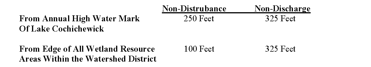
There shall exist a Non-Discharge Buffer Zone within the Watershed Protection District which shall consist of all land areas located between two hundred fifty (250) feet and four hundred (400) feet horizontally from the annual mean high water mark of Lake Cochichewick and between one hundred fifty (150) feet and four hundred (400) feet horizontally from the edge of all wetland resource areas (as defined in M.G.L. Chapter 131, Section 40, and the Town Wetland Bylaw) located within the Watershed.�
i. Allowed Uses: All of the Allowed Uses listed in Section 3 (a)(i) of this Watershed Protection District Bylaw are allowed in the Non-Discharge Buffer Zone except as noted below: �
ii. Uses Allowed by Special Permit: The following activities may be allowed within the Non-Discharge Buffer Zone only by the granting of a Special Permit issued pursuant of Section 4 of this Watershed Protection District Bylaw:�
(1) Any surface or sub-surface discharge, including but not limited to, storm water runoff; drainage or any roadway that is maintained by the Division of Public Works or any private association; outlets of all drainage swales; outlets of all detention ponds. All storm water management systems shall employ Best Management Practices. �
iii. Prohibited Uses: The following uses are specifically prohibited within the Non-Discharge Buffer Zone.�
(1) All of the Prohibited Use listed in Section 3(c)(iii) of this Watershed Protection District Bylaw are prohibited in the Non-Discharge Zone.�
(2) The use, or method of application of, any lawn care or garden product (fertilizer, pesticide, herbicide) that may contribute to the degradation of the public water supply. (3) The used of lawn care or garden products that are not organic or slow-release nitrogen. �
iv. Building Requirements: All construction in the Watershed Protection District shall comply with the best management practices for erosion, siltation, and storm water control in order to preserve the purity of the ground water and the lake; to maintain the ground water table; and to maintain the filtration and purification functions of the land.�
c. Non-Disturbance Buffer Zone �
There shall exist a Non-Disturbance Buffer Zone within the Watershed Protection District which shall consist of all land areas located between one hundred fifty (150) feet and two hundred fifty (250) feet horizontally from the annual mean high water mark of Lake Cochichewick, and between seventy five (75) feet and one hundred fifty (150) feet horizontally from the edge of all wetland resource areas (as defined in M.G.L. Chapter 131, Section 40, and the Town Wetland Bylaw) located within the Watershed.�
�
i. Allowed Uses: All of the Allowed Uses listed in Section 3 (a)(i) of this Watershed Protection District Bylaw are allowed in the Non-Disturbance Zone except as noted. �
ii. Uses allowed by Special Permit: The following uses shall be allowed within the Non-Disturbance Buffer Zone only by Special Permit issued pursuant to Section 4 of this Watershed Protection district Bylaw:�
(1) Any activities which cause a change in topography or grade.�
(2) Vegetation removal or cutting, other than in connection with agricultural uses or maintenance of a landscape area.�
(3) Construction of a new permanent structure only after a variance has been granted by the Zoning Board if Appeals.�
(4) Replacement of any permanent structure.�
(5) Any surface or sub-surface discharge, including but not limited to, storm water runoff; drainage of any roadway that is maintained by the Division of Public Works or any private association; outlets of all drainage swales; outlets of all detention ponds.�
(6) Construction of any accessory structure or expansion of any existing structure by less than twenty five (25) percent of the gross floor if the existing structure exceeds 2,500 square feet. (2006/41)�
(7) Construction of any accessory structure or expansion of any existing structure by less than fifty (50) percent of the gross floor area of the existing primary structure is less then 2,500 square feet and the primary structure will be connected to municipal sewer upon completion of the project. (2006/41) �
iii. Prohibited Uses: The following uses are specifically prohibited within the Non-Disturbance Buffer Zone:�
(1) All of the Prohibited Uses listed in Section 3(c)(iii) of this Watershed Protection District bylaw are prohibited in the Non-Discharge Zone.�
(2) Construction of any septic system.�
(3) Construction of any new permanent structure, or expansion of an existing structure except as allowed by Special Permit per Section 3.c.ii.�
(4) The use, or method of application of, any lawn care or garden product (fertilizer, pesticide, herbicide) that may contribute to the degradation of the public water supply. �
(5) The use of lawn care or garden products that are not organic or slow-release nitrogen. �
iv. Building Requirements: all construction in the Watershed Protection District shall comply with best management practices for erosion, siltation, and storm water control in order to preserve the purity of the ground water and the lake; to maintain the ground water table; and to maintain the filtration and purification functions of the land.�
d. Conservation Zone �
There shall exist a Conservation Zone within the Watershed Protection District which shall consist of all land areas located within one hundred fifty (150) feet horizontally from the annual mean high water mark of Lake Cochichewick, and within seventy five (75) feet horizontally from the edge of all wetland resource areas (as defined in M.G.L. Chapter 131, Section 40, and the town Wetland Bylaw located within the Watershed.�
i. Allowed Uses: The following uses shall be allowed in the conservation Zone of the Watershed Protection District except as noted below:�
(1) All uses associated with municipal water supply/treatment and public sewer provided by the Town of North Andover.�
(2) The Division of Public Works may conduct routine maintenance of any existing use of property, including the maintenance and improvements of existing roadways and drainage systems.�
(3) Maintenance of fire access lanes by the fire Department. �
ii. Uses Allowed by Special Permit: No Special Permits will be granted in the Conservation Zone. �
iii. Prohibited Uses: The following uses are specifically prohibited within the conservation Zone:�
(1) All of the Prohibited Uses listed in Section 3(c)(iii) of this Watershed Protection district bylaw are prohibited in the Non-Discharge Zone.�
(2) Any activities which cause a change in topography or grade;�
(3) Vegetation removal or cutting, other than in connection with existing agricultural uses or maintenance of an existing landscape area;�
(4) Construction or placement of any new permanent structures;�
(5) Any surface or subsurface drainage, including, but not limited to, storm water runoff;�
(6) Animal feedlots or the storage of manure;�
(7) Construction of any septic system.�
(8) Construction of any accessory structure or expansion of any existing structure by twenty-five (25) percent or more of the gross floor area of the existing structure.�
(9) The use, or method of application of, any lawn care or garden product (fertilizer, pesticide, herbicide) that may contribute to the degradation of the public water supply.�
(10) The use of lawn care or garden products that are not organic or slow-release nitrogen.�
The above prohibitions shall not apply to any activities undertaken by the Division of Public Works within its authority or to work completed in conjunction with the construction of the municipal sewer system. (1994/ISTM)�
4. Special Permit Requirements�
a. Nine (9) copies of an application for a Special Permit under this Section shall be filed with the SPGA. Special Permits shall be granted if the SPGA determines that the intent of the Bylaw, as well as its specific criteria, are met. In making such determination the SPGA shall give consideration to simplicity, reliability, and feasibility of the control measures proposed and the degree of threat to water quality which would result if the control measures failed.�
b. Upon receipt of a Special Permit Application, the SPGA shall transmit one (1) copy of each to the Division of Public Works, Fire Chief, Title III Committee, Division of Planning and Community Development, Conservation Commission, the Board of Health, and the Watershed Council for their written recommendations. Failure to respond in writing within thirty (30) days shall indicate approval or no desire to comment by said agency.�
c. An application for a Special Permit under this Section shall include the following information:�
i. Application Form for a Special Permit from the Planning Board. �
ii. Map on a scale of one (1) inch equals forty (40) feet prepared by a Registered Professional Engineer or Surveyor showing:�
(1) the annual mean high water mark of Lake Cochichewick (if annual mean high water mark is within four hundred (400) feet of any proposed activity,�
(2) the edge of all wetland resource areas, as confirmed by the Conservation Commission (if edge of wetland resource area is within four hundred (400) feet of any proposed activity),�
(3) the conservation zone,�
(4) the non-disturbance zone,�
(5) the non-discharge zone,�
�
(6) the edge of vegetation clearing (edge of work). �
iii. Written certification by a Registered Professional Engineer, or other scientist educated in and possessing extensive experience in the science of hydrology and hydrogeology, stating that there will not be any significant degradation of the quality or quantity of water in or entering Lake Cochichewick. �
iv. Proof that there is no reasonable alternative location outside the Non-Disturbance and/or Non-Discharge Buffer Zones, whichever is applicable, for any discharge, structure, or activity, associated with the proposed use to occur. (1994/38)�
v. Evidence of approval by the Mass. Dept. of Environmental Protection (DEP) of any industrial wastewater treatment or disposal system or any wastewater treatment of system fifteen thousand (15,000) gallons per day capacity. �
vi. Evidence that all on-site operations including, but not limited to, construction, waste water disposal, fertilizer applications and septic systems will not create concentrations of Nitrogen in groundwater, greater than the Federal limit at the down gradient property boundary. �
vii. Projections of down gradient concentrations of nitrogen, phosphorus and other relevant chemicals at property boundaries and other locations deemed pertinent by the SPGA.�
d. The SPGA may also require that supporting materials be prepared by other professionals including, but not limited to, a registered architect, registered landscape architect, registered land surveyor, registered sanitarian, biologist, geologist or hydrologist when in its judgment the complexity of the proposed work warrants the relevant specified expertise.�
e. Special Permits under this Section shall be granted only if the SPGA determines, after the time of comment by other Town agencies as specified above has elapsed, that, as a result of the proposed use in conjunction with other uses nearby, there will not be any significant degradation of the quality or quantity of water in or entering Lake Cochichewick.�
f. Any Special Permit issued under this Section for a new permanent structure (other than an accessory structure or expansion that is less than twenty five (25%) of the gross floor area of a structure) or a septic system shall require that such structure or system be constructed outside the Non-Disturbance Buffer Zone.�
g. Within the Non-Disturbance Zone and Non-Discharge Buffer Zone, any runoff from impervious surfaces shall, to the extent possible, be recharged on site and diverted toward areas covered with vegetation for surface infiltration. Where on site recharge is not feasible due to soil or other natural conditions, other mitigating measures such as sedimentation ponds, filter berms, or restoring wetlands, shall be used only where other methods are not feasible and after approval by the Board of Health, Building Inspector and the Division of Public Works to assure that the methods used for on site infiltration and/or other measures sh all remain effective.�
�
h. Provisions shall be made to protect against toxic or hazardous material discharge or loss resulting from corrosion, accidental damage, spillage or vandalism through measures such as spill control provisions in the vicinity of chemical or fuel delivery points; secured storage areas for toxic or hazardous materials, and indoor storage provisions for corrodible or dissolved materials. For operations which allow the evaporation of toxic materials into the interior of any structure a closed vapor system shall be provided for each structure to prevent discharge or contaminated condensate into the groundwater.�
i. For any toxic or hazardous waste to be produced in quantities greater than those associated with normal household use, the applicant must demonstrate the availability and feasibility of disposal methods which are in conformance with M.G.L. Chapter 21C.�
5. Emergencies�
a. The Planning Board may issue an emergency special permit, subject to the subsequent consideration and determination by the Planning Board and upon the following findings: �
i) the work proposed is deemed necessary for the protection of the quantity of quality of the water in or entering Lake Cochichewick, and �
ii) the proposed work must be undertaken before the regular special permit application processed could be completed.�
b. A request for an emergency special permit shall be made in writing to the Planning Board and shall include the following: �
i) a statement as to why the emergency work is necessary to protect the quality and/or quantity of water in and/or entering Lake Cochichewick, and,�
ii) a statement as to why the emergency work must be undertaken before the completion of the regular special permit application process, and �
iii) a statement describing in detail the proposed work to remedy the emergency situation.�
c. All information required by Section 4/136(4) Special Permit Requirements must also be submitted with the application; provided however, that if all the required information or documents are not available due to the emergency nature of the situation, the applicant may request a waiver or delay regarding the submittal of the unavailable information or documents.�
d. Authorized emergency work must be performed within 60 days of the issuance of the emergency special permit. Any work, which is not completed within this 60-day period requires compliance with the regular special permit application procedures set forth in section 4.136.4 and renumbering Violations 4.136(6) and Severability 4.136(7).�
6. Violations �
Written Notice of any violation of this Bylaw shall be provided by the SPGA agent to the owner of the premises specifying the nature of the violation. The agent of the SPGA shall request of the violator a schedule of compliance, including cleanup of spilled materials. Such schedule shall allow for the immediate corrective action to take place. This compliance schedule must be reasonable in relation to the public health hazard involved and the difficulty of compliance. In no event shall more than thirty (30) days be allowed for either compliance or finalization of a plan for longer term of compliance. Said schedule of compliance shall be submitted to the SPGA for approval subsequent to the violation. Said agent of the SPGA shall notify the Building Inspector of any violations of the Schedule of compliance or of any failure to satisfy the requirements of this paragraph. (1998/25).�
7. Severability �
In any portion, sentence, clause or phase of this regulation shall be held invalid for any reason, the remainder of this Bylaw shall continue in full force.�
8. Waiver of Watershed Protection District Special Permit�
1) When any construction proposed on an existing structure within the Watershed Protection District will not expand the existing footprint of a structure, and will not disturb existing topography, and is a proposal on town sewer, the Planning Board may determine, without a public hearing, that submission of a watershed protection district special permit is not required. However, in order to obtain such a waiver, an applicant must schedule and agree in writing for the Town Planner to perform a minimum of two inspections during the construction process to ensure proper erosion control is established during construction; the applicant must also agree in writing that the Town Planner can stop construction if the proper erosion control is not in place. For all proposals on septic, this section will not apply, and all applicants should refer to Sections 4.136(3)(a)(b)(c) and (d) of the Town of North Andover Zoning Bylaw.�
2) The applicant must request a waiver from obtaining a Watershed Protection District Special Permit in writing and may be required to submit supporting documentation, including, but not limited to, proposed plans and correspondence depicting the proposal. The waiver request will be discussed at a regular meeting of the Planning Board. (Section 4.136 rewritten and reorganized at the May 1, 1995 Annual Town Meeting, Article 38) 4.137Flood Plain District (1993/39)�
4.137 Floodplain District�
1. STATEMENT OF PURPOSE �
The purpose of the floodplain District is to:�
a. Ensure public safety through reducing the threats to life and personal injury.�
b. Eliminate new hazards to emergency response officials;�
�
c. Prevent the occurrence of public emergencies resulting from water quality, contamination, and pollution due to flooding.�
d. Avoid the loss of utility services which if damaged by flooding would disrupt or shut down the utility network and impact regions of the community beyond the site of flooding;�
e. Eliminate costs associated with the response and cleanup of flooding conditions;�
f. Reduce damage to public and private property resulting from flooding waters.�
2. FLOODPLAIN DISTRICT BOUNDARIES AND BASE FLOOD EVALUATION AND FLOODWAY DATA �
The Floodplain District is herein established as an overlay district. The underlying permitted uses are allowed provided that they meet the Massachusetts State Building Code, Section 3107, "Flood Resistant Construction" and any other applicable local, state or federal requirements. The District includes all special flood hazard areas designated on the North Andover Flood Insurance Rate Map (FIRM) issued by the Federal Emergency Management Agency (FEMA) for the administration of the NEIP dated June 2, 1993 as Zone A, AE, AH, AO, A99, and the FEMA Flood Boundary & Floodway Map dated June 2, 1993, both maps which indicate the 100 year regulatory floodplain. The exact boundaries of the District may be defined by the 100-year base flood evaluations shown on the FIRM and further defined by the Flood Insurance study booklet dated June 2, 1993. The FIRM, Floodway Maps and Flood Insurance Study booklet are incorporated herein by reference and are on file with the Town Clerk, Planning Board, Building Official, and Conservation Commission.�
3. BASE FLOOD ELEVATION AND FLOODWAY DATA�
a. Floodway Data. In Zone A, AH, A99 and AE, along watercourses that have not had a regulatory floodway designated, the best available Federal, State, local or other floodway data as determined by the Building Inspector, in consultation with the Director of the Division of Public Works, shall be used to prohibit encroachments in floodways which would result in any increase in flood levels within the community during the occurrence of the base flood discharge.�
b. Base Flood Elevation Date. Base flood elevation data is required for subdivision proposals or other developments greater than 50 lots or 5 acres, whichever is the lesser, within unnumbered A zones.�
c. Areas designated as flood plain on the North Andover Flood Insurance Rate Maps may be determined to be outside the flood plain district by the Building Inspector, in consultation with the Director of the Division of Public Works, if an accurate topographic and property line survey of the area conducted by a registered professional engineer or land surveyor shows that the flood plain contour elevation does not occur in any area of proposed buildings, structures, improvements, excavation, filling, paving, or other work activity. The person requesting the determination shall provide any other information deemed necessary by the Building Inspector, in consultation with the Director of Division of Public Works to make that determination. If the Building Inspector, in consultation with the Director of the Division of Public Works, determines that the Flood Insurance Rate Maps are in error, the subject area shall not be regulated as occurring within the Flood Plain District, and any such determination shall be noted on the Flood Insurance Rate Maps. Nothing in this section shall prohibit the Conservation Commission, Board of Health, or other Town officials or Board from making non-zoning determinations of the flood plain or performing their official duties.�
4. NOTIFICATION OF WATERCOURSE ALTERATION �
If a landowner or project proponent proposes to alter or relocate any watercourse, that person shall notify the following parties and provide evidence of such notification to every town board or official who has jurisdiction over such alteration or relocation prior to or at the time of applying for any approval that is required to perform such alteration of relocation:�
a. Notify in a riverine situation, the following of any alteration or relocation of a watercourse:�
1. Adjacent Communities�
2. Bordering States�
3. NFIP State Coordinator�
Massachusetts Office of Water Resources�
251 Causeway Street Suite 600-700�
Boston, MA 02114-2104�
4. NFIP Program Specialist �
FEMA Region I, Rm. 462 �
J.W. McCormick Post Office & Courthouse�
Boston, MA 02109�
5. REFERENCE TO EXISTING REGULATIONS �
The Floodplain District is established as an overlay district to all other districts. All development in the district, including structural and non-structural activities, whether permitted by right or by special permit must be in compliance with Chapter 131, Section 40 of the Massachusetts General Laws and with the following:�
a. Section of the Massachusetts State Building Code which addresses Floodplain and coastal high hazard areas (currently 780 CMR 3107.0 "Flood Resistant Construction");�
b. Wetlands Protection Regulations, Department of Environmental Protection (DEP) (currently 310 CMR 10.00);�
c. Inland Wetlands Restriction, DEP (currently 302 CMR 6.00);�
d. Coastal Wetlands Restriction, DEP (currently 302 CMR 4.00);�
e. Minimum Requirements for the Subsurface Disposal of Sanitary Sewage, DEP (currently 310 CMR 15, Title 5);�
f. Any variances from the provisions and requirements of the above referenced state regulations may only be granted in accordance with the required variance procedures of these state regulations.�
6. OTHER USE/DEVELOPMENT REGULATIONS �
a. Within zones AH and AO on the FIRM, adequate drainage paths are required around structures on slopes, to guide floodwaters around and away from proposed structures.�
b. Within Zones A1-30 and AE, along watercourses that have a regulatory floodway designated on the North Andover FIRM of Flood Boundary & Floodway Map dated June 2, 1993; encroachments are prohibited in the regulatory floodway which would result in any increase in flood levels within the community during the occurrence of the base flood discharge. However, a registered professional engineer may provide proof and certification to the Building Commissioner, in conjunction with the Director of the Division of Public Works, demonstrating that such encroachments shall not increase flood levels during the occurrence of the 100 year flood, and if both the Building Commissioner, in conjunction with the Director of the Division Public Works approve this certification, such encroachments shall not be deemed to be prohibited.�
c. All subdivision proposals filed in accordance with M.G.L. Chapter 41, Section 81S and 81T [or any revisions to the subdivision control law referencing the submission of preliminary or definitive subdivision plans], respectively shall be designed so that:�
1. such proposals minimize flood damage;�
2. all public utilities and facilities are located and constructed to minimize or eliminate flood damage; and�
3. adequate drainage is provided to reduce exposure to flood hazards.�
4. Existing contour intervals of site and elevations of existing structures must be included on plan proposal;�
5. The applicant shall circulate or transmit one copy of the development plan to the Conservation Commission, Planning Board, Board of Health, Town Engineer, and Building Commissioner for comments which will be considered by the appropriate permitting board prior to issuing applicable permits.�
7. PERMITTED USES �
The following uses of low flood damage potential and causing no obstruction to flood flows are encouraged provided they are permitted in the underlying district and they do not require structures, fill or storage of materials or equipment:�
a. Agricultural uses such as farming, grazing, truck farming, horticulture, etc.�
b. Forestry and nursery uses.�
c. Outdoor recreational uses, including fishing, boating, play areas, etc.�
d. Conservation of water, plants, wildlife.�
e. Wildlife management areas, foot, bicycle, and/or horse paths.�
f. Temporary non-residential structures used in connection with fishing, growing, harvesting, storage, or sale of crops raised on the premises.�
g. Buildings lawfully existing prior to the adoption of these provisions.�
8. DEFINITIONS: The following definitions are taken from the NFIP regulations and the Massachusetts State Building Code, Section 3107.�
a. AREA OF SPECIAL FLOOD HAZZARD is the land in the floodplain within a community subject to a one percent or greater chance of flooding in any given year. The area may be designated as Zone A, AO, AH, A1-30, AE, A99 V1-30, VE, or V.�
b. BASE FLOOD means the flood having one percent chance of being equaled or exceeded in any given year.�
c. COASTAL HIGH HAZARD AREA means the area subject to high velocity waters, including but not limited to hurricane wave wash or tsunamis. The area is designated on a FIRM as ZONE V, V1 -3 0, and VE.�
d. DEVELOPMENT means any manmade change to improved or unimproved real estate, including but not limited to building or other structures, mining, dredging, filling, grading, paving, excavation or drilling operations.�
e. DISTRICT means floodplain district.�
f. EXISTING MANUFACTURED HOME PARK OR SUBDIVISION means a manufactured home park or subdivision for which the construction of facilities for servicing the lots on which the manufactured homes are to be affixed (including at a minimum, the installation of utilities, the construction of streets, and either final site grading or the pouring of concrete pads) and is completed before the effective date of the floodplain management regulations adopted by a community.�
g. EXPANSION TO AN EXISTING MANUFACTURED HOME PARK OR SUBDIVISION means the preparation of additional sites by the construction of facilities for servicing the lots on which the manufactured homes are to be affixed (including the installation of utilities, the construction of streets, and either final site grading or the pouring of concrete pads).�
h. FEDERAL EMERGENCY MANAGEMENT AGENCY (FEMA) means the agency that administers the National Flood Insurance Program. FEMA provides a nationwide flood hazard area mapping study program for communities as well as regulatory standards for development in the flood hazard areas.�
i. FLOOD BOUNDARY AND FLOODWAY MAP means an official map of a community issued by FEMA that depicts, based on detailed analyses, the boundaries of the 100-year and 500-year floods and the 100-year floodway. (For maps done in 1987 and later, the floodway designation is included on the FIRM.)�
j. FLOOD HAZARD BOUNDARY MAP (FHBM) means an official map of a community issued by FEMA where the boundaries of the flood and related erosion areas having special hazards have been designated as Zone A or E.�
k. FLOOD INSURANCE RATE MAP (FIRM) means an official map of a community on which FEMA has delineated both the areas of special flood hazard and the risk premium zones applicable to the community.�
l. FLOOD INSURANCE STUDY (FIS) means an examination, evaluation, and determination of flood hazards, and, if appropriate, corresponding water surface elevations, or an examination, evaluation and determination of flood-related erosion hazards.�
m. FLOODWAY means the channel of a river or other watercourse and the adjacent land areas that must be reserved in order to discharge the base flood without cumulatively increasing the water surface elevation.�
n. LOWEST FLOOR means the lowest floor of the lowest enclosed area (including basement or cellar). An unfinished or flood resistant enclosure, usable solely for parking of vehicles, building access or storage in an area other than a basement area is not considered a building's lowest floor, PROVIDED that such enclosure is not built so as to render the structure in violation of the applicable non-elevation design requirements of NFIP Regulations 60.3.�
�
o. MANUFACTURED HOME means a structure, transportable in one or more sections, which is built on a permanent chassis and is designed for use with or without a permanent foundation when connected to the required utilities. For floodplain management purposes the term "manufactured home" also includes park trailers, travel trailers, and other similar vehicles placed on a site for greater than 180 consecutive days. For insurance purposes, the term "manufactured home" does not include park trailers, travel trailers, and other similar vehicles.�
p. MANUFACTURED HOME PARK OR SUBDIVISION means a parcel (or contiguous parcels) of land divided into two or more manufactured home lots for rent or sale.�
q. NEW CONSTRUCTION means, for floodplain management purposes, structures for which the "start of construction" commenced on or after the effective date of a floodplain management regulation adopted by a community. For the purpose of determining insurance rates, NEW CONSTRUCTION means structures for which the "start of construction" commenced on or after the effective date of an initial FIRM or after December 31, 1974, whichever is later.�
r. NEW MANUFACTURED HOME PARK OR SUBDIVISION means a manufactured home park or subdivision for which the construction of facilities for servicing the lots on which the manufactured homes are to be affixed (including, at a minimum, the installation of utilities, the construction of streets, and either final site grading or the pouring of concrete pads) is completed on or after the effective date of the floodplain management regulations adopted by a community.�
s. ONE-HUNDRED-YEAR FLOOD - see BASE FLOOD.�
�
t. REGULATORY FLOODWAY - see FLOODWAY�
�
u. SPECIAL FLOOD HAZARD AREA means an area having special flood and/or flood related erosion hazards, and shown on an FHBM or FIRM as Zone A, AO, A1-30, AE, A99, AH, V, V1-30, VE.�
v. START OF CONSTRUCTION includes substantial improvement, and means the date the building permit was issued, provided the actual start of construction, repair, reconstruction, rehabilitation, addition, placement, or other improvement was within 180 days of the permit date. The actual start means either the first placement of permanent construction of a structure on site, such as the pouring of slab or footings, the installation of piles, the construction of columns, or any work beyond the stage of excavations; of the placement of a manufactured home on a foundation. For a substantial improvement, the actual start of construction means the first alteration of any wall, ceiling, or floor or other structural part of the building, whether or not that alteration affects the external dimensions of the building.�
w. STRUCTURE means, for floodplain management purposes, a walled and roofed building, including a gas or liquid storage tank that is principally above ground, as well as a manufactured home. STRUCTURE, for insurance coverage purposes, means a walled and roofed building, other than a gas or liquid storage tank that is principally above ground and affixed to a permanent site, as well as a manufactured home on foundation. For the latter purpose, the term includes a building while in the course of construction, alteration, or repair, but does not include building materials or supplies intended for use in such construction, alteration, or repair, unless such materials or supplies are within an enclosed building on the premises.�
x. SUBSTANTIAL DAMAGE means damage of any origin sustained by a structure whereby the cost of restoring the structure to its before damaged condition would equal or exceed 50 percent of the market value of the structure before the damage occurred.�
y. SUBSTANTIAL IMPROVEMENT means reconstruction, rehabilitation, addition or other improvement of a structure, the cost of which equals or exceeds 50 percent of the market value of the structure before "start of construction" of the improvement. This term includes structures, which have incurred "substantial damage", regardless of the actual repair work performed.�
z. ZONE A means the 100-year floodplain area where the base flood elevation (BFE) has not been determined. To determine the BFE, use the best available federal, state, local, or other data. �
aa. ZONE A1 - A30 and ZONE AE (for new and revised maps) means the 100-year floodplain where the base flood elevation has been determined. �
bb. ZONE AH AND ZONE AO means the 100-year floodplain with flood depths of 1 to 3 feet. �
�
cc. ZONE A99 means areas to be protected from the 100-year flood by federal flood protection system under construction. Base flood elevations have not been determined. �
dd. ZONES B, C, AND X are areas identified in the community Flood Insurance Study as areas of moderate or minimal flood hazard. Zone X replaces Zones B and C on new and revised maps. �
ee. ZONE V means a special flood hazard area along a coast subject to inundation by the 100- year flood with the additional hazards associated with storm waves. Base flood elevations have not been determined. �
ff. ZONE V1-30 AND ZONE VE (for new and revised maps) means a special flood hazard area along a coast subject to inundation by the 100-year flood with additional hazards due to velocity (wave action). Base flood elevations have been determined.�
�

