
[Added 8-23-2005 by L.L. No. 30-2005]
It is the intention of the Huntington Town Board to protect and safeguard scenic landscapes and the vegetative features of steeply-sloped lands throughout the Town of Huntington. The Board recognizes that development in hillside areas disrupts the aesthetic and scenic qualities of these sites and adversely impacts surrounding properties by disrupting the surrounding natural vegetation and wildlife habitat, increasing the risk of stormwater runoff, flooding, surface erosion, sudden slope failure and soil movement. This legislation seeks to establish specific regulations for development and density outside conventional zoning controls by which the adverse impacts to adjoining properties and steep slopes will be ameliorated to the greatest extent possible not only during development of these sites but thereafter. It also seeks to safeguard the lives and welfare of the public by providing for a safe means of ingress and egress for vehicular and pedestrian travel and by providing adequate and safe access for fire district vehicles and other emergency personnel.
A. No building permit shall be issued and no site plan or subdivision shall be approved by any town department, agency or board for the development of land in a R-80, R-40, R-20, R-15, R-10, R-7, R-5, R-3M, R-RM, C-1, C-3, C-4 and C-8 zoning district, if any portion of the property is a Hillside Area until the provisions of this Article have been applied.
B. This Article shall apply to residential development in all zoning districts pursuant to a special use permit, use variance, area variance or other town-issued land-use approval.
C. This Article applies to any zoning district created after August 31, 2005 if the district permits (a) residential development as a principal use, (b) multi-family structures, or (c) mixed-uses when it includes residential development.
D. This Article applies to the resubdivision of any lot included in a subdivision map or site plan approved by the Planning Board before August 31, 2005.
E. This Article shall apply to new development on vacant lots and for new buildings which replace existing buildings on lots containing Hillside Areas.
F. This Article applies to the issuance of a building permit for additions to an existing buildings if the building footprint is increased by fifty (50%) percent or more, and any portion of the construction is or will be located within a Hillside Area.
G. Exemptions.
(1) Hillside Areas included in a site plan approved by the Planning Board shall not be referred back to the Planning Board for further review under 5198-64 when an application for a permit is filed, except that Planning Board review is required if the plan submitted with the application deviates from the plan originally approved by the Board.
(2) The lot yield of subdivision maps which have received conditional final approval from the Planning Board before August 31, 2005 shall be exempt from further review by the Planning Board except as required under § 198-64 for the development of each particular lot.
(3) If all construction, clearing and grading activities are outside of a Hillside Area, the building permit application does not have to be reviewed by the Planning Department or Planning Board.
(4) Emergency situations, as determined by the Director of Engineering Services, where the disturbance of steep slopes is required to protect persons, wildlife and property from imminent danger.
For the purpose of this Article the following terms shall have the meanings indicated:
BUILDING FOOTPRINT -- The amount of land covered, or proposed to be covered, on a lot by a principal building and attached accessory structures. A principal building shall be measured along the plane of its outermost boundaries, whether or not such boundaries are located on, below or above the ground on pilings, on a slab, or any combination thereof. For the purpose of this article, an attached garage or other structure attached to the principal building, including but not limited to carports, porches, pergolas, greenrooms, sunrooms and any habitable space shall be considered part of the footprint. The eaves of a roof that project beyond a principal building; patios; decks and arbors shall not be considered part of the footprint.
CONSTRUCTION OR DEVELOPMENT -- Activities which include clearing and/or grading of land.
GARAGE -- A structure, whether or not attached to the principal building, which is designed or used for the storage of a motor vehicle(s).
HILLSIDE AREA (STEEP SLOPE) -- A geographical area, whether natural or manmade and whether on one or more lots, having an average slope of 10% or greater. For the purpose of this Article, a slope of 10% shall be equivalent to a vertical rise of 10 feet in a horizontal distance of 100 feet.
The average slope of a Hillside Area shall be calculated by measuring the rise (vertical) in elevation between consecutive contour lines that shall be shown at two-foot intervals on the map, and averaging the measurements taken at each twenty-five foot horizontal interval (run), or any remaining portion of an interval as needed to reach the property boundary. The measurements shall be taken perpendicular to the lower contour lines. The total rise (vertical measurements) shall be divided by the total run (horizontal measurements) to reach the resulting average slope percentage. The average slope percentage shall be stated to two decimal points or hundredths (e.g. 18.25). If this calculation is generated by the applicant on a computer using computer aided design software (CAD), proof shall be submitted in digital format that is readable in the software program used by the Town. Such calculation shall be subject to review and approval by the Director of Planning and Environment.
A. The number of lots for that portion of a subdivision which is not a Hillside Area shall be determined by the Planning Board in accordance with current zoning requirements and subdivision regulations for the zoning district in which the property is located.
B. In no event shall property subject to the provisions of this article contain an area less than the minimum required by the zoning district in which the property is located, except in the case of a modified subdivision approved by the Planning Board pursuant to the town code and § 278 of the Town Law or any successor law.
C. Lot yield. The number of lots permitted in a Hillside Area shall be determined by calculating the average slope percentage and applying the lot yield factor shown in the following table. The Planning Board shall make the final determination of the number of lots permitted in Hillside Areas.
Lot Yield for Hillside Areas
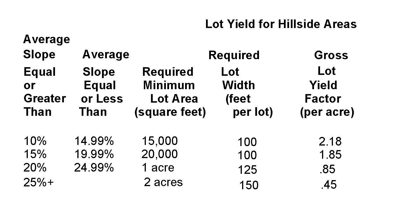
D. The number of lots to be permitted in the subdivision shall be the total yield from the Hillside Area and the flat area, if a flat area is determined to exist. If there is no flat area, then the total number of lots shall be those yielded from the Hillside Area. The yield calculation for the Hillside Area shall be rounded from the hundredths position to the nearest whole number (e.g., 1.50 requires 2 large lots; 1.49 requires 1 large lot).
E. Lot yield alternative. At the applicant's discretion, as an alternative to the lot yield method provided in (C) and (D) above, lot yield may be determined by deducting Hillside Areas from the yield of the property in their entirety. Lots in the flat portion(s) of the property shall meet the zoning requirements for the district in which they are located without using any area(s) within the Hillside Area. As a condition of approval, if this alternative is utilized no portion of the Hillside Area(s) shall be built upon or developed. Covenants and restrictions establishing a conservation area which preserves the Hillside Area(s) in their natural state in perpetuity shall be submitted to the Town Attorney for approval as to form and content. Upon approval by the Town Attorney, the applicant shall record the document in the Office of the Suffolk County Clerk at his or her own cost and expense and provide the Town Attorney and Department of Planning and Environment with a copy of the recorded instrument. The liber and page of each instrument recorded shall be shown on the final subdivision map submitted to the Director of Planning before the final map will be signed by the Director.
F. Any oversized lot that is created pursuant to (C) above shall be considered to be Bally yielded and is not to be further subdivided. The applicant shall submit covenants and restrictions explaining the reason(s) the lot was created and prohibiting further subdivision of the newly created lot in perpetuity to the Town Attorney for approval as to form and content. Upon approval of the Town Attorney, the applicant shall record the document in the Office of the Suffolk County Clerk at his or her own cost and expense and provide the Town Attorney and Department of Planning and Environment with a copy of the recorded instrument. The liber and page of each instrument recorded shall be shown on the final subdivision map submitted to the Director of Planning before the final map will be signed by the Director.
G. Park set-aside requirements: In all cases, the requirement for parkland set-aside shall be determined from the portion of land used to calculate lot yield.
A. No building permit to construct, clear or grade land for residential development on individual building lots containing Hillside Area(s) shall be issued until the provisions of this article have been applied.
B. Procedure. All building permit applications filed in the Department of Engineering Services shall include photographs of the property from the street and photographs of the areas of the lot affected by the proposed construction, clearing and/or grading. A sworn and notarized affidavit signed by the property owner shall be submitted with the application attesting that the parcel has no Hillside Areas; or if it does, that no part of the proposed work, clearing and/or grading will occur in such areas. In addition to an affidavit from the property owner, the Director of Engineering Services may, at his discretion, request a sworn and notarized affidavit by a licensed surveyor or professional engineer bearing the original seal and attesting that the parcel has no Hillside Areas or that the proposed construction, clearing and/or grading will not be performed in such areas. The Director may also require a topographical survey showing elevations at two (2) foot intervals. If a field inspection determines that a false statement or misrepresentation has been made, a stopwork order shall be issued and the permit revoked. The applicant will be required to file a new building permit application, pay the requisite fees, and go through the review provided by this Article. In all cases, a topographical survey will be required for construction, clearing or grading in Hillside Areas.
C. The Department of Engineering Services shall forward all building permit applications not exempted by this article including topographical surveys to the Director of Planning and Environment for review prior to issuing building permits. The Director of Planning and Environment shall make the final determination of the average slope percentage and such determination shall control further review of the application for a building permit.
D. Review. If the average slope percentage is 10% or greater, the Department of Planning and Environment will review applications for compliance with this Article. The review will take into consideration the degree of slope and size of the sloped area affected by construction; the attempt by the applicant to minimize or mitigate development on steep slopes: the locations of proposed and/or existing buildings, accessory buildings and structures: the location of driveways and lawn areas; soil classifications; flora and fauna; unique environmental features; neighborhood impacts and other factors deemed necessary by the Department.
E. The Department of Planning and Environment shall submit its written findings and recommendations to the Planning Board. No building permit shall be issued for construction on any portion of a Hillside Area without the review and approval of the Planning Board. The Planning Board can require changes to a site plan in order to protect steep slopes and the environment, and may require such conditions and restrictions as deemed necessary to assure compliance with all applicable laws, rules and standards. The Planning Board will confine development to the least-sloped portion of the property whenever appropriate, taking into account the degree of slope, the suitability of the location for construction, attempts to mitigate clearing and grading, the environmental features of the lot, and compliance with the intent of this article.
F. Compliance with conditions. If the Planning Board requires that covenants and restrictions be filed as a condition of receiving a building permit for work in a Hillside Area, the applicant shall submit the covenants and restrictions to the Town Attorney for approval as to form and content. Upon approval by the Town Attorney, the applicant shall record the document in the Office of the Suffolk County Clerk at his or her own cost and expense and provide the Town Attorney, the Department of Planning and Environment, and the Department of Engineering Services with a copy of the recorded instrument before any permits can be issued by the Department of Engineering Services. Any permit issued before the covenants are filed and all other conditions are met shall be null and void.
G. Building Footprint. If any portion of the building footprint is in a Hillside Area, the building footprint shall be subject to the maximum ground floor area shown in the following chart:
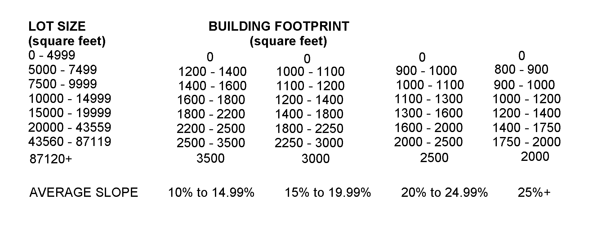
H. Method of calculating the building footprint. The maximum building footprint permitted by this Article shall be calculated as follows:

(1) Begin with the actual square footage of the lot and deduct from such footage the minimum lot size shown for the applicable category, For example, a 12,000 square foot lot with an average slope of 23% would result in the following: 12,000-10,000 or 2,000. The resulting number (2,000) is divided by the difference between the maximum lot size and the minimum lot size shown for such category (i.e., 14,999 - 10,000 or 4,999). The calculation would result in a final number of .40 (i.e., 2,000 ,999),
(2) Multiply that number (.40) by the difference between the maximum building footprint and the minimum building footprint shown for the category (i.e., 1,300 - 1,100 = 200, so .40 x 200 = 80). Add to that number (80) the minimum building footprint to find the maximum building footprint permitted for the particular lot size (80 + 1,100 = 1,180).
(3) If the building footprint permitted by this Article is shown on the chart as a single number, then all lots falling within the lot size category to which it applies shall be subject to the same building footprint.
I. A lot modified by the Planning Board pursuant to Town Law § 278 shall be subject to the building footprint limits which would have applied had no modification taken place.
J. Accessory structures. In no event shall the ground floor area exceed the following designated limits:
(1) Detached garages shall not exceed 650 square feet if construction, clearing or grading will occur on average slopes of between 10% to 19.99%, and 400 square feet if construction, clearing or grading will occur on average slopes of 20% or more. If. however, the building footprint is less than the maximum ground floor area permitted by this article, then the remaining floor area may be allocated to a detached garage. Said additional allocation shall reduce the potential building footprint.
(2) If built outside of Hillside Areas, the lot coverage of decks and patios (whether or not building permits are required) shall not be greater than permitted for the zoning district where the property is located. If any portion is built on an average slope in excess of or equal to 20%, lot coverage shall not exceed 200 square feet or as permitted in the zoning district, whichever is less, and the grade of the land on which the deck or patio is to be located cannot be altered for their construction. If any portion is built on average slopes of 10% to 19.99%, lot coverage shall not exceed 400 square feet or as permitted in the zoning district, whichever is less, and the grade of the land on which the deck or patio is to be located cannot be altered for their construction.
(3) Shed or other structures over 200 square feet, tennis courts and other recreational courts/structures shall be prohibited in any portion of a Hillside Area. Sheds and other structures over 100 square feet and all pools shall be prohibited on average slopes equal to or greater than to 20%.
(4) The grade of land on which fences and non-structural walls are to be located cannot be altered for their construction.

