For the purpose of limiting and restricting to specified districts, and regulating therein buildings and structures according to their construction and the nature and extent of their use, and the nature and extent of the use of land, and to regulate and restrict the height, number of stories, and size of buildings and other structures, the percentage of lot that may be occupied, the size of yards, courts and other open spaces, the density of population, and the location and use and extent of use of buildings and structures and land, for trade, industry, residence or other purposes excluding municipally owned and operated or municipally operated buildings and related premises used for governmental purposes, the City of Newark is hereby divided into districts, of which there shall be twelve (12) in number, known as:�
�
First Residence District�
Second Residence District�
Third Residence District�
Fourth Residence District�
First Business District�
Second Business District�
Third Business District�
Fourth Business District�
First Industrial District�
Second Industrial District�
Third Industrial District�
Hospital District�
(R.O. 1966 C.S. § 27:2-1; Ord. 6 S+FU, 3-6-96)�
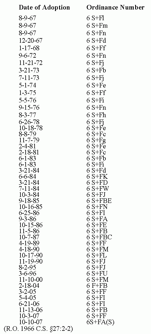
Editor's Note: The "Zoning District Map" was further amended and changed by the following ordinances:�

The boundaries of the districts set forth in Section 40:2-1 shall be as shown and delineated on the "Zoning District Map" of the City, which map accompanies and is declared to be part of this Zoning Chapter.�
a. "Zoning District Map" shall be amended on sheet 10 so that properties designated on the Tax Map as City Tax Block 1869, 1870 and 1871 in their entirety and the vacated portion of South Ninth Street between Ninth Avenue and West Market Street, shall be removed from the Third Residence District and become the Hospital District.�
b. Sheets 1, 2, 3, 4, 5, 6, 10, 11, 12, 13, 14, 15, 16, 17, 19, 21, 22, 23 and 26 of the Zoning District Map, City of Newark as described in Section 40:2-2 and declared part of Title 40, Zoning Regulations of the Revised Ordinances of the City of Newark, New Jersey, 2000, as amended and supplemented, be further amended in accordance with the attachment labeled "Exhibit A, Areas to be converted from Second Industrial District to First Industrial District," such that all shaded areas be redesignated as First Industrial District areas.�
c. Sheets 9 and 10 of the Zoning District Map, City of Newark as described in Section 40:2-2 and declared part of Title 40, Zoning Regulations of the Revised Ordinance of the City of Newark, New Jersey, 2000, as amended and supplemented, be further amended in accordance with the attachment labeled "Exhibit A: Areas to be converted to First Industrial District" such that all shaded areas be redesignated as First Industrial District areas.�
d. Sheet 26 of the Zoning District Map of Title 40, Zoning of the Revised Ordinances of the City of Newark, New Jersey, 2000, as amended and supplemented to rezone blocks 5092.02, 5092.03, and 5092.04 in their entirety from the First Industrial District Designation to the Second Residential District Designation. Exhibit A attached denotes the area to be rezoned on said Sheet 26 of the Zoning District Map of Title 40, Zoning of the Revised General Ordinances of the City of Newark, New Jersey, 2000, as amended and supplemented.�
e. The overlay zones for the City Historic Districts of James Street, Four Corners, Military Park Commons, Forest Hill, Weequahic Park, Lincoln Park and North Broad Street, denoted in the attached Exhibit "A" are hereby added to the Zoning District Map of Title 40, Zoning of the Revised Ordinances of the City of Newark, New Jersey, 2007, as amended and supplemented.�
(R.O. 1966 C.S. §27:2-2; Ord. 6 S+FU, 3-6-96 §1; Ord. 6 S+FF, 3-2-05 §1; Ord. 6 S+FT, 5-4-05 §1; Ord. 6 S+FI, 6-21-06; Ord. 6 S+FB, 11-13-06 §1; Ord. 6 S+FF, 10-307 §1; Ord. 6S+FA(S), 10-10-07 §1)�
Editor's Note: Exhibit A, referred to herein, may be found on file in the office of the City Clerk.�
Where uncertainty exists with respect to the boundaries of the various districts as shown on the map accompanying and made a part of this Title, the following rules shall apply:�
a. Where the district boundaries are either streets or alleys, unless otherwise shown, and where the districts designated on the map accompanying and made a part of this Title are bounded approximately by streets or alley lines, the center line of the street or alley shall be construed to be the boundary of such district.�
b. The district boundaries are, unless otherwise indicated, either street lines or lines drawn parallel to and one hundred (100) feet back from one (1) or more of the street lines bounding a block. Where two (2) or more district designations are shown within a block two hundred (200) feet or less in width, the boundaries of the less restricted district shall be deemed one hundred (100) feet back from its street line. Where two (2) or more district designations are shown within a block more than two hundred (200) feet in width, the boundaries of the more restricted district shall be deemed one hundred (100) feet back from its street line.�
(R.O. 1966 C.S. §27:2-3)�
Whenever lands or territory shall hereafter be acquired by annexation, the lands or territory shall be deemed to be zoned as it was prior to annexation in the municipality from which it was acquired. (R.O. 1966 C.S. §27:2-4)�