
A. Sketch plats and preliminary site plans, in order to be acted upon by the Board at its next regularly scheduled meeting, shall be filed with the Planning Board Secretary 30 days prior to the regular meeting of the Planning Board. At the time of application, the developer shall pay all fees and submit required copies of the application, maps and other documents as required by this chapter. Furthermore, any application for development located within the CAFRA review zone shall be accompanied by a memorandum of record from the division, all as set forth in the rules and regulations under the Coastal Area Facility Review Act, N.J.S.A. 13:19-1 et sec. [Amended 6-11-1980 by Ord. No. 15-1980]�
B. Classification; minor subdivisions.�
(1) The Planning Board or designated Subdivision Committee shall classify the application. If classified as a minor subdivision, the minor subdivision shall be approved or denied within 45 days of the date of submission of a complete application to the administrative officer or within such further time as may be consented to by the applicant. Failure of the Planning Board to act within the period prescribed shall constitute minor subdivision approval, and a certificate of the administrative officer as to the failure of the Planning Board to act shall be issued on request of the applicant; and it shall be sufficient in lieu of the written endorsement or other evidence of approval herein required and shall be so accepted by the County Recording Officer for purposes of filing subdivision plats.�
(2) Whenever review or approval of the application by the County Planning Board is required by Section 5 of P.L. 1968, c. 285 (N.J.S.A. 40:27-6.3), the Municipal Planning Board shall condition any approval that it grants upon timely receipt of a favorable report on the application by the County Planning Board or approval by the County Planning Board by its failure to report thereon within the required time period.�
(3) Approval of a minor subdivision shall expire 190 days from the date of municipal approval unless within such period a plat in conformity with such approval and the provisions of the Map Filing Law, P.L. 1960, c. 141 (N.J.S.A. 46:23-9.9 et sec.), or a deed clearly describing the approved minor subdivision is filed by the developer with the County Recording Officer, the Municipal Engineer and the Municipal Tax Assessor. Any such plat or deed accepted for such filing shall have been signed by the Chairman and Secretary of the Planning Board.�
(4) The zoning requirements and general terms and conditions, whether conditional or otherwise, upon which minor subdivision approval was granted shall not be changed for a period of two years after the date of minor subdivision approval, provided that the approved minor subdivision shall have been duly recorded as provided in this section.�
(5) Before the Planning Board Secretary returns any approved sketch plat to the subdivider, the subdivider, at his own expense, shall have sufficient copies made to furnish one copy to the Township Clerk.�
(6) If the plat is classified as a major subdivision, a notation to that effect shall be made on the plat, which will be returned to the subdivider for compliance with the procedures in 198-6 and 198-7 of this chapter.�
C. Preliminary site plan.�
(1) The developer shall submit to the Planning Board Secretary a site plan and such other information as required herein. If an application for site plan is found to be incomplete, the developer shall be notified by the Planning Board Secretary within 45 days of the submission of such application, or it shall be deemed to be properly submitted.�
(2) If the Planning Board requires any substantial amendment in the layout of improvements proposed by the developer that have been the subject of a hearing, an amended application for development shall be submitted and proceeded upon, as in the case of the original application for development. The Planning Board shall, if the proposed development complies with the chapter and this Act, grant preliminary site plan approval. �
(3) Upon the submission to the Planning Board Secretary of a complete application for a site plan for 10 acres of land or less, the Planning Board shall grant or deny preliminary approval within 45 days of the date of submission or within such further time as may be consented to by the developer. Upon the submission of a complete application for a site plan of more than 10 acres, the Planning Board shall grant or deny preliminary approval within 95 days of the date of such submission or within such further time as may be consented to by the developer. Otherwise, the Planning Board shall be deemed to have granted preliminary approval of the site plan.�
A. At least 10 black-on-white prints of the preliminary plat, together with two completed application forms for preliminary approval, shall be submitted to the Planning Board Secretary 30 days prior to the Planning Board meeting at which consideration is desired. At the time of filing, fees in accordance with
B. The developer shall submit to the Planning Board Secretary plats and such other information as is required in
C. If the Planning Board requires any substantial amendment in the layout of improvements proposed by the developer that have been the subject of a hearing, an amended application shall be submitted and proceeded upon as in the case of the original application for development. The Planning Board shall, if the proposed subdivision complies with this chapter and this Act, grant preliminary approval to the subdivision.�
D. Upon the submission to the Planning Board Secretary of a complete application for a subdivision of 10 or fewer lots, the Planning Board shall grant or deny preliminary approval within 45 days of the date of such submission or within such further time as may be consented to by the developer. Upon the submission of a complete application for a subdivision of more than 10 lots, the Planning Board shall grant or deny preliminary approval within 95 days of the date of such submission or within such further time as may be consented to by the developer. Otherwise, the Planning Board shall be deemed to have granted preliminary approval to the subdivision.�
E. Notification.�
(1) The developer shall notify by registered mail or certified mail, at least 10 days prior to the hearing, all property owners within 200 feet of the extreme limits of the subdivision as their names appear on the municipal tax record. Furthermore, the developer shall comply with all provisions of N.J.S.A. 40:55D 12a through g, as applicable.�
(2) Said notice shall state the time and place of hearing, a brief description of the subdivision and that a copy of said subdivision has been filed with the Planning Board Secretary for public inspection. The applicant shall also cause notice of the hearing to be published in the official newspaper or a newspaper of general circulation in the municipality at least 10 days prior to the hearing.�
F. Copies of the preliminary plat shall be forwarded by the Secretary of the Planning Board prior to the hearing to the following:�
(1) County Planning Board. �
(2) Planning consultant. �
(3) Township Engineer. �
(4) County Board of Health. �
(5) Such other municipal, county or state officials as directed by the Planning Board.�
G. If the Planning Board acts favorably on a preliminary plat, a notation to that effect shall be made on the plat.�
H. Effect of preliminary approval. �
Preliminary approval of a major subdivision pursuant to this chapter or of a site plan, except as provided in Subsection D of this section, confer upon the applicant the following rights for a three-year period from the date of the preliminary approval.�
(1) That the general terms and conditions on which preliminary approval was granted shall not be changed, including but not limited to use requirements; layout and design standards for streets, curbs and sidewalks; lot size; yard dimension and off-tract improvements; and, in the case of a site plan, any requirements peculiar to site plan approval, except that nothing herein shall be construed to prevent the municipality from modifying by ordinance such general terms and conditions of preliminary approval as relate to public health and safety.�
(2) That the applicant shall submit for final approval on or before the expiration date of preliminary approval the whole or a section or sections of the preliminary subdivision plat or site plan, as the case may be.�
(3) That the applicant may apply for and the Planning Board may grant extensions on such preliminary approval for additional periods of at least one year but not to exceed a total extension of two years, provided that, if the design standards have been revised by ordinance, such revised standards may govern.�
(4) In the case of a subdivision or of a site plan for an area of 50 acres or more, the Planning Board may grant the rights referred to in Subsection H(1), (2) and (3) above for such period of time, longer than three years, as shall be determined by the Planning Board to be reasonable, taking into consideration the number of dwelling units and nonresidential floor area permissible under preliminary approval, economic conditions and the comprehensiveness of the development. The applicant may apply for thereafter and the Planning Board may thereafter grant an extension to preliminary approval for such additional period of time as shall be determined by the Planning Board to be reasonable taking into consideration the number of dwelling units and nonresidential floor area permissible under preliminary approval, the potential number of dwelling units and nonresidential floor area of the section or sections awaiting final approval, economic conditions and the comprehensiveness of the development, provided that if the design standards have been revised, such revised standards may govern.�
A. Time limits.�
(1) The final plat shall be submitted to the Planning Board Secretary for forwarding to the Planning Board for final approval within three years from the date of preliminary approval. The Planning Board shall act upon the final plat within 45 days after the date of submission for final approval. Failure of the Planning Board to act within the period prescribed shall constitute final approval, and a certificate of the administrative officer as to the failure of the Planning Board to act shall be issued on request of the applicant, and it shall be sufficient in lieu of the written endorsement or other evidence of approval herein required and shall be so accepted by the County Recording Officer for purposes of filing subdivision plats.�
(2) Whenever review or approval of the application by the County Planning Board is required by Section 5 of P.L. 1968, c. 285 (N.J.S.A. 40:27-6.3), in the case of a subdivision, or Section 8 of P.L. 1968, c. 285 (N.J.S.A. 40:27-6.6), in the case of a site plan, the Municipal Planning Board shall condition any approval that it grants upon timely receipt of a favorable report on the application by the County Planning Board or approval by the County Planning Board by its failure to report thereon within the required time period.�
B. The applicant shall submit one reproducible Mylar copy, 10 black-on-white prints and two copies of the application form for final approval to the Secretary of the Planning Board at least 30 days prior to the date of the regular Planning Board meeting. Unless the preliminary plat is approved without changes, the final plat shall have incorporated all changes or modifications by the Planning Board.�
C. The final plat shall be accompanied by a statement by the Township Engineer that he is in receipt of a map showing all utilities or extensions thereof in exact location and elevation, identifying those portions already installed and those to be installed, and that the subdivider has complied with one or both of the following:�
(1) Installed all improvements in accordance with the requirements of these regulations.�
(2) A performance guaranty has been posted with the Township insufficient amount to assure the completion of all required improvements.�
D. Upon final approval, copies of the final plat shall be filed by the Planning Board with the following:�
[Amended 10-10-1979 by Ord. No. 28-1979]�
(1) Township Clerk (subdivision plats only). �
(2) Township Engineer. �
(3) Construction Official. �
(4) Tax Assessor. �
(5) County Planning Board (subdivision plats only). �
(6) Official issuing certificate for approved lots. �
(7) Township Road Superintendent.�
E. The final plat, after final approval, shall be filed by the subdivider with the County Recording Officer within 95 days from the date of such approval. If any final plat is not filed within this period, the approval shall expire. The Planning Board may, for good cause, extend the period for recording for an additional period not to exceed 190 days from the date of signing of the plat.�
F. No plat shall be accepted for filing by the County Recording Officer unless it has been duly approved by the Planning Board of the Township of Egg Harbor and signed by the Chairman and Secretary of the Board.�
[Amended 6-11-1980 by Ord. No. 15-1980; 9-9-1981 by Ord. No. 25-1981; 4-131983 by Ord. No. 10-1983; 4-25-1984 by Ord. No. 11-1984; 3-13-1985 by Ord. No. 12-1985; 9-14-1988 by Ord. No. 34-1988; 9-9-1992 by Ord. No. 42-1992; 5-28-1997 by Ord. No. 19-1997]�
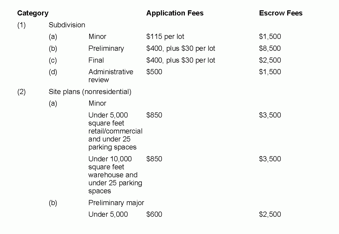
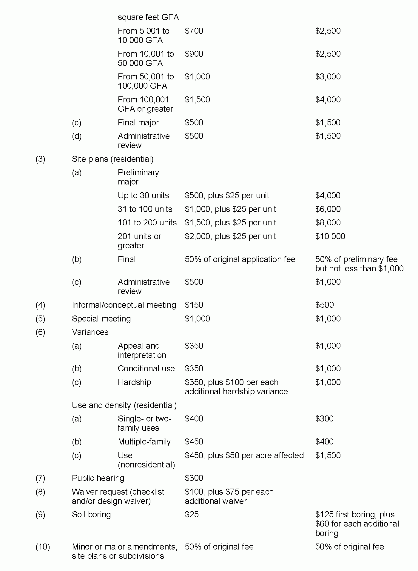
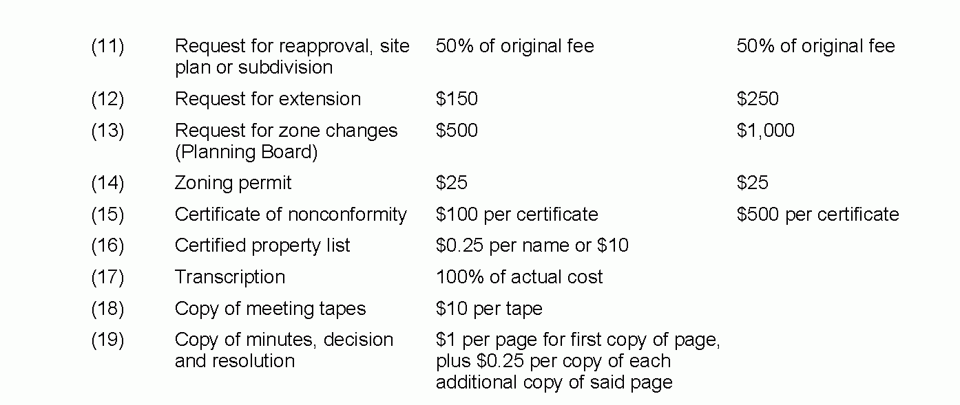
A. The schedule of fees shall be as follows: [Amended 10-22-1997 by Ord. No. 46-1997; 10-9-2002 by Ord. No. 60-2002]�
B. Application of escrow fees. [Amended 10-9-2002 by Ord. No. 60-2002]�
(1) The application fees and escrow fees recited hereinabove are minimums which must accompany the application. An application shall not proceed until the application fee and escrow fee required have been paid. The Land Use Administrator shall exercise his/her discretion in establishing the figure required for the escrow fund, in the event the project will require more time for review than has been provided for by the figures recited hereinabove, or the project is of a nature that is not expressly included in one of the aforementioned categories.�
(2) Application fees and escrow must be submitted in separate checks payable to Egg Harbor Township. The escrow fee shall be forwarded by the Land Use Administrator to the Treasurer of Egg Harbor Township for deposit into a developer's escrow account. The application fees shall be deposited into the general account of Egg Harbor Township.�
(3) Funds shall be applied to professional costs charged to the Township by professional consultants (planner, engineer, attorney, and any other consultant or specialist retained by the Board) for services or review regarding the development application. Additional funds may be required when the original amount is depleted by 50% and the development application is still in progress. The amount of additional funds needed shall be determined by the Land Use Administrator.�
(4) All escrow amounts not actually used shall be refunded pursuant to those requirements listed within N. J. S. A. 40:55D-53.2d.�
C. Exemption from the payment of any fee charged in connection with any application for development which promotes accessibility by a disabled person to their own living unit. In accordance with N.J.S.A. 40:55D-8e, a disabled person, or a parent or sibling of a disabled person, shall be exempt from the payment of any fee charged in connection with any application for development which promotes accessibility to his own living unit. [Added 11-24-1998 by Ord. No. 37-1998]�
A. The Planning Board, when acting upon applications for preliminary or minor subdivision approval, shall have the power to grant such exceptions from the requirements for subdivision approval as may be reasonable and within the general purpose and intent of the provisions for subdivision review if the literal enforcement of one or more provisions of this chapter is impracticable or will exact undue hardship because of peculiar conditions pertaining to the land in question.�
B. The Planning Board when acting upon applications for preliminary site plan approval shall have the power to grant such exceptions from the requirements for site plan approval as may be reasonable and within the general purpose and intent of the provisions for site plan review if the literal enforcement of one or more provisions of this chapter is impracticable or will exact undue hardship because of peculiar conditions pertaining to the land in question.�
A. The following checklist is designed to assist applicants in preparing plans for Planning Board/Zoning Board of Adjustment review. The applicant should check off each item and submit the checklist with the application to ensure that the information is included on the plan. Items omitted will delay consideration by the Board.�
The subdivision/sketch plan shall show the following information and be drawn according to all relevant standards set forth in this Chapter 198, Subdivision of Land and Site Plan Review, and in Chapter § 225, Zoning, of the Township Code. One or more of the following informational items may not be applicable in all cases. The person preparing the plan should indicate, in writing, on the plan those items not applicable.�
Items A(26), (27) and (29) are applicable in all cases and cannot be waived. [Amended 2-14-1979 by Ord. No. 2-1979; 6-11-1980 by Ord. No. 15-1980; 7-22-1981 by Ord. No. 15-1981; 11-18-1992 by Ord. No. 51 1992; 2-24-1993 by Ord. No. 8-1993]�
(1) The plans shall be submitted on one of the following sheet sizes: 15 inches by 21 inches, 24 inches by 36 inches, 30 inches by 42 inches. No other size will be accepted.�
(2) The plan shall be drawn or reproduced at a scale of not less than one inch equals 50 feet.�
(3) A key map at a scale of either one inch equals 1,000 feet or one inch equals 2,000 feet, showing the entire subdivision and its relation to surrounding areas within 2,000 feet. Such map shall show all existing land uses within 200 feet of the land being subdivided.�
(4) The tract name, Tax Map sheet, block and lot numbers, zoning district and zoning requirements, North arrow, scale, date of preparation and all revisions. [Amended 7-14-1993 by Ord. No. 30-1993]�
(5) Existing topography at two-foot intervals within the subject property and extending 50 feet from the property lines. [Amended 7-14-1993 by Ord. No. 30-1993]�
(6) The name and address of owner and subdivider and owners of land within 200 feet of the outer boundary of lands to be subdivided, as disclosed by the most recent municipal tax records.�
(7) The name, address and signature of person preparing the plan. The plan shall be prepared, signed and sealed by a licensed New Jersey land surveyor, engineer, planner or architect as required by state regulation.�
�
(8) The map must include provisions for signatures of the Planning Board or Zoning Board Chairman and Secretary.�
(9) A survey of the property prepared by a New Jersey licensed land surveyor, with bearings and distances provided for all property lines.�
(10) The acreage of the tract to be subdivided, to the nearest 1/10 of an acre, and the proposed number of lots, including the area and dimensions of each proposed lot.�
(11) Locations of all existing structures, showing existing and proposed front, rear and side yard setback distances, and an indication of whether the existing structures and uses will be retained or removed.�
(12) The names, locations and dimensions (cartway and right-of-way widths) of all streets.�
(13) Sight triangles, the radii of curbline and street sign locations shall be clearly indicated at all intersections.�
(14) Site characteristics maps showing the location of existing and proposed property lines, streets, street names, buildings, watercourses, railroads, bridges, culverts, easements, rights-of-way and any natural features, such as wooded areas, streams or wetlands. All historically, cultural and/or archaeological significant structures or resources shall be shown.�
(15) The location of all wetland areas and required wetland transition areas or buffers within the proposed development as required pursuant to the New Jersey Freshwater Wetlands Protection Act or the Comprehensive Management Plan, and a letter from either the New Jersey Department of Environmental Protection and Energy (NJDEPE) or the Pinelands Commission indicating that the proposed subdivision does not require a wetlands delineation.�
(16) A copy of the any existing and/or proposed protective covenants or deed restrictions applying to the land being subdivided shall be submitted with the preliminary plat, if applicable.�
(17) Soil boring information as required in 94-44 of the Township Code.�
(18) When on-site septic systems are proposed in areas under CAFRA jurisdiction, soils borings, permeability test results and the approximate location of the intended septic disposal field in accordance with 94-24P of the Township Code.�
(19) Proposed connections to existing water supply and sanitary sewer systems, or alternative means of providing these services noted.�
(20) Areas in which construction is precluded due to the presence of stream corridors and/or steep slopes.�
(21) The location of temporary stakes to enable the Planning Board to find and appraise features of the sketch plat or minor subdivision in the field.�
(22) The location of existing wells and septic systems.�
(23) The location of all monuments, corners and other points established in the field, whether set or to be set. The material of which the monuments, corners or other points are made shall be noted at the representation thereof or by legend. The legend for metal monuments shall indicate the kind of metal, the diameter, length and weight per linear foot of the monuments.�
(24) The purpose of any proposed easement of land reserved or dedicated to public or common use shall be designated and the proposed use of site other than residential shall be noted.�
(25) The plan/project shall be designed in compliance with the subdivision and zoning ordinances of the Township and other applicable standards of the state, county and local agencies.�
(26) All applicable fees must be paid with the submission.�
(27) No application will be deemed complete until all taxes and sewer assessments are paid up-to-date.�
(28) In the Pinelands Area, no application shall be deemed complete until a certificate of filing from the Pinelands Commission or other evidence of Pinelands Commission review in accordance with Chapter
(29) The maps for submission must be folded and have the title block clearly visible.�
B. Purpose. �
The purpose of this section is to discourage development on lots unsuitable for conventional septic system use due to environmental constraints and to require larger minimum lot sizes dependent upon the depth of the seasonal high-water table and percolation rate. [Added 11-9-1988 by Ord. No. 39-1988] �
C. Percolation data. [Added 11-9-1988 by Ord. No. 39-1988]�
(1) When a public sewage disposal system is not available, results of percolation tests witnessed by the Township Engineer or Atlantic County Health Department shall be submitted for each unimproved lot. The results shall include the following information:�
(a) Date of test. �
(b) Soil log to a minimum depth of 10 feet, plotted to scale. �
�
(c) Depth at which groundwater was encountered. �
(d) An evaluation of depth to seasonal high- groundwater level. �
(e) Location of test. �
(f) Name of the witness of the test. �
(g) Rate of percolation in minutes per inch.�
(h) Depth at which the percolation test was taken.�
(2) Where a topographic survey is required by other portions of this section, the application must show surface elevations at each boring location.�

