
1. In addition to the performance standards and design criteria requirements of §§19-402 and 19-403 and §§19-405 through 19-407 of this Chapter, the applicant shall comply with the following water quality requirements unless otherwise exempted by provisions of this Chapter.�
A. The applicant shall first provide infiltration facilities in areas where soils are suitable for infiltration and shall direct the runoff from impervious surfaces into those infiltration facilities. The volume of storage to be provided shall be no less than the net increase in runoff from the 2-year storm event, or 1 inch of runoff from the total area draining to the infiltration facility, whichever is Beater.�
B. If a perennial or intermittent stream passes through the site, the applicant shall create a riparian buffer extending a minimum of 75 feet to either side of the top of the bank of the channel. The buffer area shall be maintained with appropriate native vegetation (see list of technical references in Appendix C of this Chapter). If the applicable rear or side yard setback is less than 75, the buffer width may be reduced to 25% of the setback to a minimum of 10 feet upon approval of the Board of Supervisors. If an existing buffer is legally prescribed (e.g., deed covenant, easement, etc.) and it exceeds the requirement of this Chapter, the existing buffer shall be maintained.�
C. Detain the 2-year, 24-hour design storm runoff based on using the SCS Type II distribution. Provisions shall be made so that the detained runoff takes a minimum of 24 hours to drain from the facility from a point where the maximum volume of water is captured (i.e., the maximum water surface elevation is achieved in the facility). Release of water can begin at the start of the storm (i.e., the invert of the water quality orifice is at the invert of the facility). The design of the facility shall consider and minimize the chances of clogging and sedimentation potential. The applicant may also utilize infiltration facilities in lieu of extended detention. The volume of infiltration provided for the contributing area may be deducted from the volume requirement for extended detention.�
2. The applicant shall submit designs for water quality facilities to the Township Engineer for review and approval. Such designs may achieve the water quality objectives through a combination of BMPs.�
�
3. In selecting the appropriate BMPs or combinations thereof, the applicant shall consider the following:�
A. Total contributing area.�
B. Permeability and infiltration rate of the site soils.�
C. Slope and depth to bedrock.�
D. Seasonal high water table.�
E. Proximity to building foundations and well heads.�
F. Erodibility of soils.�
G. Land availability and configuration of the topography.�
H. Consistency with approved watershed and stormwater management plans or regulations.�
4. The following additional factors should be considered when evaluating the suitability of BMPs used to control water quality at a given development site:�
A. Peak discharge and required volume control.�
B. Streambank erosion.�
C. Efficiency of the BMPs to mitigate potential water quality problems.�
D. The volume of runoff that will be effectively treated.�
E. The nature of the pollutant being removed.�
F. Maintenance requirements.�
G. Creation/protection of aquatic and wildlife habitat.�
H. Recreational value.�
I. Enhancement of aesthetic and property value.�
(Ord. 4-2004, 6/2/2004, §404)�
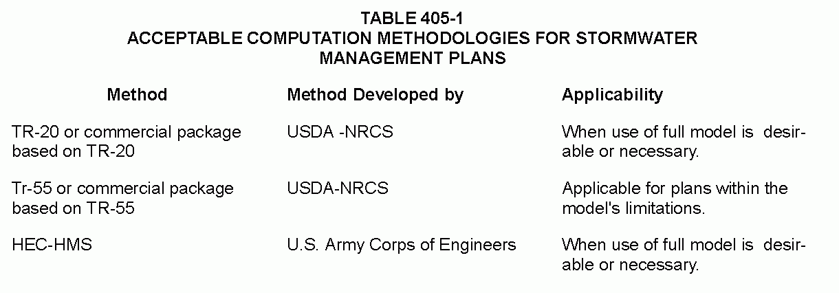
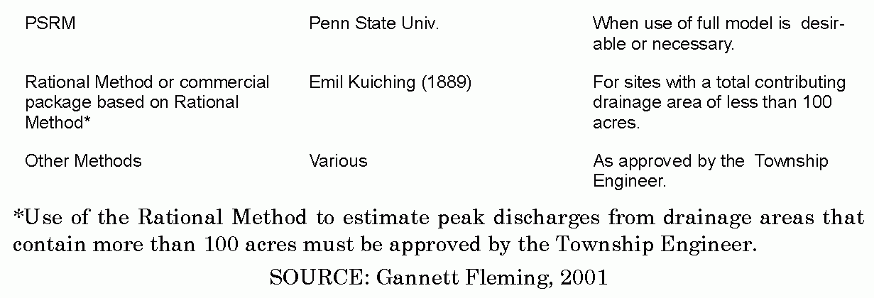
1. Any stormwater runoff calculations involving drainage areas greater than 200 acres, including on-and off-site areas, shall use a generally accepted calculation technique that is based on the NRCS soil-cover complex method. Table 405-1 summarizes acceptable computation methods. It is assumed that all methods will be selected by the design professional based on the individual limitations and suitability of each method for a particular site.�
2. All calculations consistent with this Chapter using the soil-cover complex method shall use the appropriate design rainfall depths for the various return period storms presented in Table B-1 in Appendix B of this Chapter. If a hydrologic computer model such as PSRM or HEC-1 is used for stormwater runoff calculations, then the duration of rainfall shall be 24 hours. The NRCS "S "curve shown in Figure B-1, Appendix B of this Chapter shall be used for the rainfall distribution.�
3. Flow Rate Calculations.�
A. For the purposes of pre-development flow rate determination in the Chester Creek Watershed, undeveloped land shall be considered as "meadow" good condition, type 13"soils, (RCN = 58, Rational "t;"= 0.12) unless the natural Mound cover generates a lower curve number or Rational "C" value (i.e., forest). If a proposed development meets the definition of redevelopment as defined in Article 2 of this Chapter, the applicant may adjust the pre-development RCN or "C" value based on the curves presented in Figure B-3.�
B. For the purposes of pre-development flow rate determined in the Ridley Creek watershed, computations should assume actual existing soil and land use conditions on the side as of the date of adoption of the Ridley Creek Act 167 Plan or its most recent update.�
4. All calculations using the Rational Method shall use rainfall intensities consistent with appropriate times of concentration for overland flow and return periods from the design storm curves from Pennsylvania Department of Transportation Design Rainfall Curves (1986) (Figure B-2). Times of concentration for overland flow shall be calculated using the methodology presented in Chapter 3 of Urban Hydrology for Small Watersheds, NRCS, TR-55 (as amended or replaced from time to time by NRCS). Times of concentration for channel and pipe flow shall be computed using Manning's Equation.�
5. RCNs for both existing and proposed conditions to be used in the soil-cover complex method shall be obtained from Table B-2 in Appendix B of this Chapter.�
6. Runoff coefficients (C) for both existing and proposed conditions for use in the Rational Method shall be obtained from Table B-3 in Appendix B of this Chapter.�
7. Runoff characteristics of off-site areas that drain through a proposed development shall be based on actual existing conditions, not RCN=58 or C=0.12, and shall be assumed to not have any controls implemented on future development (i.e., no release rate restrictions).�
8. Where uniform flow is anticipated, the Manning equation shall be used for hydraulic computations and to determine the capacity of open channels, pipes, and storm sewers. Values for Manning's roughness coefficient (n) shall be consistent with Table B-4 in Appendix B of this Chapter.�
9. Outlet structures for stormwater management facilities shall be designed to meet the performance standards of this Chapter using any generally accepted hydraulic analysis technique or method. Acceptable methods are presented in Handbook of Hydraulics, by King and Brater (McGraw Hill). In addition, application of computer programs such as HY-8 (Federal Highway Administration) or FlowMaster (Haestad Methods) will also be accepted.�
10. The design of any stormwater detention facilities intended to meet the performance standards of this Chapter shall be verified by routing the design storm hydrograph through these facilities using the storage-indication method. For drainage areas greater than 20 acres in size, the design storm hydrograph shall be computed using a calculation method that produces a full hydrograph. The Township may approve the use of any generally accepted full hydrograph approximation technique that uses a total runoff volume that is consistent with the volume from a method that produces a full hydrograph.�
11. The Township has the authority to require that computed existing runoff rates be reconciled with field observations and conditions. If the designer can substantiate through actual physical calibration that more appropriate runoff and time of concentration values should be utilized at a particular site, then appropriate variations may be made upon review and recommendation of the Township Engineer. Calibration shall require detailed gauge and rainfall data for the particular site in question.�
(Ord. 4-2004, 6/2/2004, §405)�

