
A. All measures for soil erosion control and sedimentation control shall be equal to or exceed the Standards for Soil Erosion and Sediment Control in New Jersey, promulgated by the New Jersey State Soil Conservation Committee and the Warren County Soil Conservation District, and Standards and Specifications for Soil Erosion and Sediment Control in Urbanizing Areas, prepared by the United States Department of Agriculture, Soil Conservation Service, Somerset, New Jersey.�
B. Disturbance shall be done in a manner which will minimize soil erosion.�
D. Natural vegetation should be retained and protected.�
E. The area and duration of the disturbance should be minimized.�
F. Temporary seeding, mulching or other suitable stabilization measures shall be used to protect exposed erodible areas during disturbance.�
G. Drainage devices shall accommodate all increased runoff resulting from modification of soil and surface conditions during and after development or disturbance.�
�
H. Soil erosion and sedimentation control measures shall be installed prior to other land disturbance.�
I. The applicant shall bear the full and final responsibility for the installation and construction of all required soil erosion and sediment control measures.�
J. In reviewing the soil erosion and sediment control plan, the Planning Board shall consider the suitability and effectiveness of the applicant's proposed plan; the existing topography, present vegetation and soil conditions of the tract; the critical and environmentally sensitive areas of the tract; applicable environmental or resource protection ordinances, statutes or regulations; and the health, safety and welfare of the public.�
A. The peak rate of runoff from a site during or after development should not exceed the predevelopment peak rate of runoff. [Amended 8-7-89 by Ord. No. 6-89]�
B. Runoff within a site should ultimately leave the site in the same watershed in which it originated.�
C. The use of cluster development and conservation easements should be considered to reduce the rate or volume of surface water runoff, to reduce the total area of impervious surfaces and to preserve open space and topographic features critical to surface water management�
D. Maximum use should be made of presently existing surface water runoff control measures, including but not limited to berms, terraces, grassed waterways, swamps, swales, ditches, woodlands, floodplains, favorable hydrologic soils or watercourses.�
E. Runoff control measures shall be used both to retard or reduce runoff and to increase recharge.�
F. Runoff control measures listed in Urban Hydrology for Small Watersheds (TR 55), United States Department of Agriculture, Soil Conservation Service (on file in the office of the Township Engineer), should be employed.�
G. Runoff values shall be calculated by the rational method (Q=CIA), the Soil Conservation Service method or by other engineering methods acceptable to the Township Engineer. Either the Warren County Engineering Department standards for the coefficient of runoff or other generally accepted engineering standards should be used.�
H. Stormwater retarding structures should control all storms occurring more frequently than once in one hundred (100) years, and discharge should not exceed the amount that would have resulted from a storm of the same frequency under predevelopment conditions.�
I. All water-carrying structures and/or retention areas should be completed and stabilized prior to diversion of water to them.�
J. In reviewing a surface water runoff plan, the Planning Board should consider its suitability or effectiveness; the existing topography, vegetation, hydrologic factors and soil conditions; the groundwater supply, groundwater recharge and discharge areas, wet soils and seasonable high-water table; the natural drainage flow and pattern; the design storm; critical and environmentally sensitive areas of the site; and land uses in both the immediate vicinity of the site and the surrounding drainage region.�
A. General. The subdivider shall observe the following requirements and principles of land subdivision in the design of each subdivision or portion thereof:�
(1) Development pattern. The subdivision plat shall conform to design standards that will encourage the most appropriate development pattern within the municipality.�
(2) Conformance to Master Plan and Official Map. Where either or both an Official Map or Master Plan has been or have been adopted, the subdivision shall conform to the proposals and conditions shown thereon. The streets, drainage rights-of-way, school sites, public parks and playgrounds shown on an officially adopted Master Plan or Official Map shall be shown on all subdivision plats and shall be considered in approval of subdivision plats.�
B. Streets. The arrangement of streets not shown on the Master Plan or Official Map shall be such as to provide for the appropriate extension of existing streets and where necessary in order to promote orderly flow of traffic, safety and welfare of the public and shall be such as to provide for appropriate extension to adjoining properties for future streets.�
(1) Classification of streets. For any subdivision, it shall be the duty of the Planning Board to classify proposed streets according to their function in providing circulation and access in the community. In making a determination as to the classification of a particular street, the Planning Board shall take into consideration the provisions of the Master Plan, the existing and proposed conditions within the subdivision and the area and potential development in proximity thereto.�
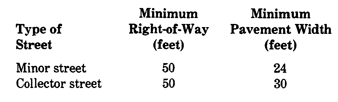
(2) Public street right-of-way widths. The street right-of way width shall be measured from abutting lot line to abutting lot line and shall be as follows:�
(3) Street pattern. Major subdivisions shall be designed so as to provide a street pattern which is curvilinear in design. The design of residential street patterns shall be based upon a local residential street pattern connected to a residential collector street system. The Planning Board, on review of subdivision applications, may limit access on existing collector roads (Quenby Mountain Road, Danville Mountain Road, Free Union Road, Mountain Lake Road, Marble Hill Road and Shades of Death Road) and onto major roads (New Jersey State Highway Route 46 and Hope-Great Meadows Road) and may require reverse frontage or construction of a local service road with a buffer strip or island as a means to separate through and local traffic.�
(4) Widening existing streets. Subdivisions that adjoin or include existing streets that do not conform to widths as shown on the Master Plan or Official Map or street width requirements of this chapter shall dedicate additional width along either one (1) or both sides of said road. If the subdivision is along one (1) side only, one-half (1/2) of the required extra width shall be dedicated. The Planning Board and Township Committee may require the developer to make improvements within the widened street area.�
(5) Dead-end streets (culs-de-sac).�
(a) No more than fifteen (15) lots shall be permitted on any cul-de-sac, which cul-de-sac shall provide a turnaround at the end with a radius of not less than fifty (50) feet, with a tangent, whenever practicable, to the right side of the street. [Amended 8-7-89 by Ord. No. 6-89]�
(b) If a dead-end street is of a temporary nature, a similar turnaround shall be provided, and provisions shall be made for future extension of the street and reversion of the excess right-of-way to the adjoining properties.�
(6) Reserve strips. No subdivision showing reserve strips controlling access to streets shall be approved, except where the control and disposal of land comprising such strips has been placed in the governing body under conditions approved by the Planning Board.�
(7) Street intersections.�
(a) Angle of intersections. No more than two (2) streets shall cross the same point. Street intersections shall be at right angles wherever possible, and intersections of less than sixty degrees (60'), measured at the center line of streets, shall not be permitted. The block corners at intersections shall be rounded at the curbline with a curve having a radius of not less than twenty-five (25) feet.�
(b) Approaches. Approaches of any collector street to any intersection of another collector street or a major street (New Jersey State Highway Route 46 and Hope- Great Meadows Road) shall follow a straight line course within one hundred (100) feet of the intersection.�
(c) [Amended 8-7-89 by Ord. No. 6-89] Sight triangles. In addition to right-of-way widths required for full lengths of streets, easements for sight rights at intersections in the shape of triangles shall be dedicated to cover the area bounded by the right-of way lines and a straight line connecting sight points on streets' center 'lines which are the following distances from the intersection of the center lines. No object of a height in excess of thirty (30) inches shall be permitted within a sight triangle. This may be further reduced depending on the topography.�
[1] Where a minor street intersects another minor street: ninety (90) feet.�
[2] Where a minor street intersects a collector street: ninety (90) feet on the minor street and two hundred (200) feet on the collector street.�
�
[3] Where a minor street or a collector street intersects a major street: ninety (90) feet on the minor street or collector street and three hundred (300) feet on the major street.�
(d) Curb radius at intersections. Curb radii at intersections shall be designed to permit turning movements of vehicles without encroachment into the opposing lanes of traffic. The minimum curb radius shall be not less than twenty (20) feet.�
(e) All points of access shall provide safe sight distances as published by the American Association of State Highway and Transportation Officials publication, Geometric Design of Highways and Streets. [Added 6-3-1991 by Ord. No. 8-91]�
(8) Property access. Unless necessary to provide access to a lot in separate ownership existing before the adoption of this chapter, no driveway access to property or additional street intersection may be permitted within the sight triangles as specified above.�
(9) Reverse curves. A tangent of at least one hundred (100) feet shall be introduced between reverse curves on collector streets.�
(10) Connecting streets. When connecting street lines deflect from each other at any one (1) point by more than ten degrees (100) and not more than forty-five degrees (450), they shall be connected by a curve with a radius of not less than one hundred (100) feet for minor streets and three hundred (300) feet for collector streets.�
(11) Street jogs. Street jogs with center-line offsets of less than one hundred twenty-flve (125) feet shall be avoided.�
(12) Grades.�
(a) Maximum grades of streets shall be as follows:�
[1] Minor streets: twelve percent (12%). [Amended 8-7-1989 by Ord. No. 6-89]�
[2] Collector streets: twelve percent (12%).�
[3] Culs-de-sac: five percent (5%). [Added 8-7-1989 by Ord. No. 6-89]�
(b) No streets shall have a minimum grade of less than one-half of one percent (1/2 of 1%). Within fifty (50) feet of the intersection of any street with a collector street or major street, the maximum grade shall be limited to two percent (2%).�
(13) Grade changes. All changes in grades in excess of one percent (1%) shall be connected by a vertical curve to provide a smooth transition and proper sight distance acceptable to the Township Engineer.�
(14) Street names.�
(a) Street names and subdivision names shall not duplicate or nearly duplicate the names of existing streets or subdivisions in the township or in surrounding communities and shall be subject to the approval of the Planning Board. The continuation of an existing street shall have the same name.�
(b) No street in the municipality shall be named so that it is the same name as any other street within the municipality. In the event of any such similarity, whether existing or in the future, the name shall be immediately changed by the Committee to sufficiently distinguish such street from any other street so that emergency, delivery, postal or other service can be accomplished expeditiously and without confusion. [Added 5-1-1995 by Ord. No. 10-95]�
C. Blocks. The lengths, widths and shapes of blocks shall be determined with due regard to:�
(1) Provision of adequate building sites suitable to the special needs of the type of use contemplated.�
(2) Zoning requirements as to lot sizes and dimensions.�
(3) Needs for convenient access, circulation, control and safety of street traffic.�
(4) Limitations and opportunities of topography.�
(5) For uses other than single-family residential, block sizes shall be sufficient to meet all area, yard and parking requirements of such particular use.�
(6) In blocks over one thousand (1,000) feet long, pedestrian walkways may be required in locations deemed necessary by the Planning Board. Such walkways shall be not less than four (4) feet wide.�
D. Lots.�
(1) Lot dimensions, front, side and rear yards and total area in square feet shall not be less than the requirements of the Zoning Ordinance.�
(2) Lots shall provide adequate size and building sites suitable to the special needs of the type of use contemplated.�
(3) Lots, houses and driveways shall be designed and laid out so that cars can be turned on the lot and shall not be backed onto any street.�
(4) Side lot lines. Insofar as is practical, side lot lines shall be at right angles to straight streets and radial to curved streets.�
(5) Lots for single-family dwellings shall provide two parking spaces improved to standards set forth in the Liberty Township Driveway Ordinance for driveways.�
(6) Unsuitable lots. All lots shall be adaptable for the purpose for which they are intended to be used without danger to health or peril from flood, fire, erosion or other menace. Where there is a question as to the suitability of a lot or lots for their intended use due to factors such as rock formations, flood conditions or similar circumstances, the Planning Board may, after adequate investigation, withhold approval of such lots.�
(7) Lot drainage. Lots shall be graded to secure proper drainage to prevent the collecting of stormwater in pools. Grading shall be performed in a manner which will -minimize the damage to or destruction of trees growing on the land.�
(8) Topsoil protection. Topsoil moved during the course of construction shall be redistributed so as to provide at least four inches of cover to all areas of the subdivision not covered by an impervious surface and may be stabilized by seeding or planting on slopes of less than 12% as shown on the final grading plan, if one is required, and shall be stabilized by sodding on slopes of 12% or over as shown on the final grading plan. No topsoil shall be removed from the site or used as spoil unless it exceeds the requirements of the preceding sentence.�
(9) Lot numbers shall be obtained from the Tax Assessor. House numbers may be secured through the post office with advice from the Tax Assessor. (Amended 8-7-1989 by Ord. No. 6-89]�
(10) Structure location and driveways. All lots shall be such that a structure conforming to the intended use and setback requirements of the Zoning Ordinance' can be constructed in an area of the lot that is:�
(a) Not within the one-hundred-year floodplain or within any wetlands or any wetlands transition area unless specifically permitted by the New Jersey Department of Environmental Protection. [Amended 8-7-1989 by Ord. No. 6-89; 10-6-1997 by Ord. No. 97-14]�
(b) At an elevation of more than five feet above mean water level of an adjacent stream or drainage course.�
(c) Otherwise in conformity with the provisions of the Zoning Ordinance' and all other ordinances or regulations of the township and any other governmental authority. Any structure must be accessible by means of an improved driveway in compliance with the Liberty Township Driveway Ordinance.�
(11) Plan. A plan and profile of any proposed driveway shall be submitted as part of site plan and/or subdivision application. Said driveway design shall, if the development be approved, be made part of said approval. Any deviation from said driveway design, unless deemed by the Township Engineer to be deminimus and properly a field change shall be returned to the reviewing board for considerations. [Added 10-6-1997 by Ord. No. 97-14]�
E. Easements.�
�
(1) Easements shall generally be located along property lines whenever practicable in order to minimize loss of private usable property land area, Easements shall be at least 20 feet wide and of sufficient width to permit installation and maintenance of facilities without encroachments on adjacent private property and shall be located in consultation with the companies or municipal departments concerned.�
(2) Where a subdivision is traversed by a watercourse, drainageway, channel or stream, there shall be provided a stormwater easement or drainage right of-way conforming substantially to the lines of such watercourse and such further width for construction and maintenance as will be adequate for the purpose.�
(3) All easement% shall be described by a metes and bounds description, and a right-of-way shall be granted to the municipality or agency which exercises jurisdiction and control of the easement area prior to any final subdivision approval. Natural features, such as trees, brooks, hilltops and views, shall be preserved, whenever possible, in designing any subdivision containing such features.�
F. Areas for public use.�
(1) Any land shown on the Master Plan as intended for parks, playgrounds, school sites or other public use shall be designated and reserved for such use. The Planning Board shall be permitted to reserve any such land for public use in accordance with the provisions of N.J.S.A. 40:55D-44. [Amended 7-6-87]�
(2) Wherever possible, subdividers shall preserve trees, groves, waterways, scenic points, historic spots and other community assets and landmarks based upon recommendation by the Shade Tree and/or Environmental Commissions.�
(3) Walkways should be provided to eliminate crossing private property. [Amended 8-7-89 by Ord. No. 6-89]�
G. Buffer areas. If a subdivision abuts an area zoned for a use different from the use permitted in the area of the subdivision, the Planning Board shall require a separation to promote the public safety and general welfare of the township and, where feasible, shall require that the lots within such a subdivision are so laid out that the rear yards of the lots abut any area zoned other than for residential use. [Amended 8-7-1989 by Ord. No. 6-89; 6-3-1991 by Ord. No. 8-91]�
H. Constraints. Constraints, delineations and calculations, as outlined in § 90-8F(8). [Added 8-7-89 by Ord. No. 6-89]�
I. [Added 8-7-89 by Ord. No. 6-89] Environmental impact statement. An environmental impact report shall be submitted with all subdivisions and site plans, except as provided below:�
(1) General provisions.�
�
(a) The term "Board" shall apply to Planning Board and the Zoning Board of Adjustment, as appropriate, throughout the remainder of this subsection.�
(b) The environmental impact generated by land developed projects necessitates a comprehensive analysis of the variety of problems. This constitutes an environmental impact statement. In evaluating environmental impact, the Planning Board and Zoning Board of Adjustment shall not approve any submission until they find and determine that the proposed development:�
[1] Will not result in appreciable harmful effects to both the natural and aesthetic environments.�
[2] Has been designed and conceived with a view toward the protection of the regional resources and energy-saving techniques.�
[3] Will not place a disproportionate or excessive demand upon the total resources available for such proposal.�
(c) In order to accomplish these goals, the Board shall condition any approval upon the agreement to implement performance controls deemed necessary to assure the protection of the environment. Any approval shall also be conditioned upon the receipt of licenses, permits or other approvals required by law. Those factors outlined in Subsection I(4)(e) below, along with supplemental requirements adopted by the Board, shall be used to determine the environmental performance controls that are necessary.�
(2) General requirements. It is further recognized that the level of detail required for various types of applications will vary depending on the size of the proposal, the nature of the site and the location of the project. Therefore, having determined that some flexibility is needed in preparing the environmental impact statement (a revised environmental impact statement may be required if significant changes to the site plan as determined by the Planning Board prior to final approval were done since original submission), the requirements for such a document are listed as follows:�
(a) Plot plan applications for a single- or two-family dwelling on an existing lot of record are specifically exempt from the environmental impact statement requirements. In addition, minor subdivisions shall, in general, be exempt unless required by the Board due to specific sensitive environmental situations. Finally, all agricultural operations are exempt that are conducted in accordance with a plan approved by the Soil Conservation District, and all silviculture operations are exempt that are conducted in accordance with a plan prepared by a professional forester or the New Jersey Division of Parks and Forests.�
(b) A preapplication conference may be held with the Township Planner and/or the Planning Board Chairman, or his designee, to determine the content of the environmental impact statement as outlined in Subsection I(4), along with any supplemental guidelines adopted by the Board. Waivers of specific environmental impact statement requirements shall be granted by the Planning Board with input from the Township Planner and Engineer.�
�
(c) When the environmental impact statement is prepared by an individual other than the applicant, the credentials and expertise of that individual shall be submitted with the environmental impact statement. All applicable material on file in the Liberty Township Municipal Building pertinent to local conditions shall be consulted. Any additional material pertinent to evaluation of potential regional impacts shall also be considered. Furthermore, as much original research as necessary shall be conducted to develop a comprehensive environmental impact statement.�
(d) The environmental impact statement shall consist of written and graphic materials which will clearly present the information that is required. The scale of all maps shall be one (1) inch equals fifty (50) feet, unless the Planner and/or Planning Board agree to another scale. Contours, when required, shall be provided at two-foot intervals for slopes of less than fifteen percent (15%) or five-foot intervals if greater than fifteen percent (15%).�
(e) Upon receipt of the environmental impact statement, the Planner shall determine within forty-five (45) days if it is complete or incomplete. If it is incomplete, it shall be returned to the applicant with recommendations regarding the additions, deletions and/or corrections which are needed.�
(f) In preparing the environmental impact statement, the applicant shall make himself aware of the requirements specified in other sections of the land development ordinances so that unnecessary duplication of effort is avoided.�
(3) Application types.�
(a) All major subdivision applications, preliminary and final site plan applications consisting of more than ten (10) acres and those minor subdivision sites lying within sensitive environmental areas shall be accompanied by an environmental impact assessment except as set forth herein. The information required shall be presented in a concise report unless environmentally sensitive areas are involved. When environmentally sensitive areas are involved, the report shall be supplemented with additional graphic and explanatory material as required during Subsection RM). Environmentally sensitive areas in Liberty Township include but are not limited to:�
[1] Stream corridors and floodplains.�
[2] Streams and water bodies.�
[3] Wetlands.�
[4] Slopes greater than fifteen percent (15%).�
[5] Erodible soils.�
[6] Mature forests of sugar maple or hemlock.�
�
[7] Aquifer recharge areas.�
[8] Aquifer discharge areas.�
[9] Unique natural features and habitats.�
[10] Residence of protected flora and fauna species.�
(b) Any use variance application not involving a site plan or subdivision application may be required, at the discretion of the Zoning Board of Adjustment, to be accompanied by an environmental impact statement. The information to be required shall be determined by the Zoning Board in consultation with the Planner.�
(4) Format. When an environmental impact statement is required, the following format shall be utilized, and the information requested shall be provided:�
(a) Project description: Indicate the purpose and scope of the proposed project. Enumerate the benefits to the public, if any, which will result from the proposed project and describe the suitability of the site for the intended use. A description of the proposed project shall be presented to indicate the extent to which the site must be altered, the kinds of facilities to be constructed, how they are to be constructed and the uses intended. The resident population, working population and visitor population shall be estimated. The compatibility or incompatibility of the proposed project shall be described in relation to the following:�
[1] The Township Master Plan, especially the land use and open space elements.�
[2] Master Plans of adjacent municipalities.�
[3] The Warren County Master Plan.�
[4] Regional and state planning guides.�
[5] Other pertinent planning documents.�
(b) Site description inventory: Provide a description of environmental conditions on the site, which shall include but not be limited to the following items:�
[1] Types of soil: a list and description of each soil type located on the site. Percolation data and soil analysis as required by the Warren County Health Department shall be provided. Where the proposed area of land disturbance will involve soils with moderate or severe limitations as per the Warren County Soil Conservation District, a complete mapping of all soil types on the site shall be required, indicating where those moderate and severe limitations exist�
[2] Topography- a description of the topographic conditions within the site and extending two hundred (200) feet beyond the property lines. When fifteen percent (15%) or more of the proposed area of land disturbance encompasses slopes in excess of fifteen percent (15%), the following slope ranges shall be mapped for the entire site:�
[a] Zero percent to fifteen percent (0% to 15%);�
[b] Sixteen percent to twenty-five percent (16% to 25%); and�
[c] Twenty-five percent (25%) and up.�
[3] Geology: a description of the geologic formations and features associated with the site as well as depth to bedrock conditions; delineation of those areas where bedrock is in close proximity to the surface, i.e., within four (4) feet of the surface, as well as major bedrock outcroppings.�
[4] Vegetation: a description of the existing vegetation on the site. When required, sketch the location of major vegetation groupings such as woodland, open field and wetland. Where woodlands are delineated, the forest type shall be indicated. It should include unique features and protected species, i.e., dogwood, black walnut trees, etc.�
[5] Surface weather: a description of existing watercourses and water bodies that are partially or totally on the site and their relationship to the area of land disturbance. Existing surface runoff from the site shall be calculated using the methods contained in Soil Conservation Survey Manual No. 55. When the natural drainage pattern will be significantly altered or sewage effluent added to a watercourse or body, an analysis shall be conducted which will investigate flow, depth, capacity and water quality of receiving waters. When required, floodplain areas shall be mapped in consultation with the Department of Environmental Protection. Existing drainage structures shall be mapped, and the capacity of the drainage network shall be determined.�
[6] Subsurface water: a description of subsurface water conditions on the site, both in terms of depth to groundwater and water supply capabilities of the site. Detailed information regarding existing wells within five hundred (500) feet of the site relative to depth, capacity and water quality shall be provided. The water supply capabilities of the adjacent areas and the recharge capabilities of the site shall be discussed.�
[7] Unique, scenic and/or historic features: a description and map of those portions of the site that have unique, scenic and/or historic qualities.�
[8] Existing development features, a description of any existing features on the site that are not considered to be part of the natural environment. This may include but not necessarily be limited to roads, housing units, accessory structures and utility lines.�
[9] Miscellaneous: An analysis shall be conducted of existing air quality and noise levels.�
[10] Energy conservation features: siting for solar access and maximum energy efficiency with respect to land features.�
�
(c) Area and regional description: A description of the surrounding area shall be provided, including existing land use patterns. The existing infrastructure, with respect to the drainage and transportation network, as well as any central sewerage and water supply facilities, shall be described in detail. An appropriate regional analysis relative to the proposed project shall be included.�
(d) Impact: Discuss the negative and the positive on-site and off-site impacts as they affect the items listed in Subsection I(4)(b)(3] and [4] above. Indicate those resources affected by the proposal which will be irretrievably lost and those resources which are renewable. The specific concerns that shall -be considered include but are not limited to the following:�
[1] Soil erosion and sedimentation resulting from surface runoff.�
[2] Flooding and floodplain disruption.�
[3] Degradation of surface water quality.�
[4] Groundwater pollution.�
[5] Reduction of groundwater capabilities.�
[6] Sewage disposal.�
[7] Solid waste disposal.�
[8] Vegetation destruction.�
[9] Disruption of wildlife habitats.�
[10] Destruction of scenic and historic features.�
[11] Air quality degradation.�
[12] Noise levels.�
[13] Energy utilization.�
[14] Neighborhood deterioration.�
[15] Effect on public services, such as schools, fire and police.�
[16] Traffic congestion.�
[17] Health, safety and welfare of existing residents.�
�
[18] Regional development policies.�
(e) Recommendations to mitigate adverse environmental impact: Describe in detail what measures will be employed during the planning, construction and operation phases which will or eliminate negative impacts on-site and off-site that could result from the proposed project. Of specific interest are:�
[1] Drainage plans, which shall include but not be limited to soil erosion and sedimentation controls. Every effort shall be made to limit off-site peak runoff to predevelopment levels.�
[2] Water supply and water conservation proposals.�
[3] Sewage disposal techniques,�
[4] Site design techniques sensitive to the natural environment, which should include innovative landscape, building and circulation design/solar access siting.�
[5] Energy conservation measures.�
[6] Noise reduction technique.�
[7] Construction schedule.�
[8] Miscellaneous on-site and off-site public improvements.�
(f) Alternatives: Discuss what alternatives were considered both in terms of building design, site design and project location. Indicate why an alternative was rejected if it would have resulted in a lesser negative impact than the subject proposal.�
(g) Licenses, permits and other approvals required by law: The applicant shall list all known licenses, permits and other forms of approval required by law for the construction and operation of the proposed project. This list shall include but will not be limited to approval required by the township as well as agencies of the county, state and federal governments. Where approvals have been granted, copies of such approvals shall be attached. Where approvals are pending, a note shall be made to that effect.�
(h) Documentation: All publications, reports, manuscripts or other written sources of information related to the project, the project site and the township which were consulted and employed in compilation of the environmental impact statement shall be listed. A list of agencies and individuals from whom pertinent information was obtained orally or by letter shall be listed separately. Dates and locations of all meetings shall be specified. A revised environmental impact statement may be required if significant changes to the site plan, as determined by the Planning Board prior to final approval, were done since original submission.�
J. Fire protection standards. [Added 6-1-1992 by Ord. No. 14-92]�
(1) [Amended 7-10-1995 by Ord. No. 14-95; 6-10-1996 by Ord. No. 96-11] All subdivisions of four (4) lots or more and all site plans shall provide a central fire protection system meeting the following minimum requirements:�
(a) All central fire protection systems shall conform to all applicable standards of the National Fire Code, American Water Works Association (AWWA), N.J.A.C. 7:10-1 through 7:10-11.13 (commonly known as the 'Safe Drinking Water Act Regulations') and any revisions or amendments thereto.�
(b) Total fire-fighting water supply shall be no less than two thousand (2,000) gallons per dwelling unit. The maximum volume of fire-fighting water supply required for residential-type units shall be fifty thousand (50,000) gallons.�
(c) Water storage facilities for fire-fighting water shall be designed to automatically maintain the required capacity for fire protection purposes.�
(d) The maximum distance from each dwelling unit to the nearest fire hydrant shall not exceed five hundred (500) feet�
(e) Each fire hydrant shall be capable of supplying a minimum flow of at least seven hundred fifty (750) gallons per minute at no less than seventy (70) pounds per square inch residual system pressure.�
(2) All nonresidential occupancies shall conform to the National Fire Code for minimum water supply requirements for fire protection purposes.�
(3) All developments must be designed to allow for the access of emergency vehicles, including fire apparatus, ambulances and police cars. Fire lanes shall be provided for commercial- and industrial type developments to provide access to fire protection facilities.�
(4) Prior to obtaining final approval of any major subdivision or site plan requiring a central fare protection system, the applicant/developer shall conduct any and all tests necessary to ensure that the system meets the fire-fighting requirements of the Fire Chief. Certification by a hydraulic engineer or other proof acceptable to the Fire Chief that the stream, well, hydrant, pond or other source of water is capable of meeting the minimum criteria contained in this code shall be provided. No certificate of occupancy shall be issued for any premises until compliance with this section is certified. [Amended 7-10-1995 by Ord. No. 14-95; amended 6-10- 1996 by Ord. No. 96-11]�
(5) Any subdivision of land that expands a previously approved subdivision that did not require a central fire protection system at the time of its creation due to the number of lots involved, to the point where a central fire protection system is required based on the total number of proposed lots and previously approved lots, shall, unless otherwise provided, install a central fire protection system capable of protecting both the proposed subdivision and the previously approved subdivision in accordance with the requirements for fire protection system standards as outlined herein.�
(6) Existing nonresidential occupancies shall be required to conform to the requirements of the National Fire Code whenever an application for site plan approval is submitted, to provide at least the minimum water supply requirements for fire protection purposes for the entire site.�
(7) [Amended 7-10-1995 by Ord. No. 14-95; 6-10-1996 by Ord. No. 96-111 Where, in the opinion of the Planning Board and after recommendation by the Township Fire Department, on-site storage facilities are necessary for subdivisions of fewer than four (4) lots or where in any subdivision or site plan a central fire suppression system is not practical, the following alternatives may be considered:�
(a) Underground water storage consisting of three or more ten-thousand-gallon water storage tanks. These should be located such that no dwelling is more than 1,000 feet from any ten thousand-gallon storage site and no more than 1,000 feet from any storage site. The tank shall include a lockable access manhole, an inspection port to inspect the water level, venting for a discharge of 1,500 gallons per minute, suction piping (six-inch minimum) connected from the bottom of the tank to a six inch suction hydrant with six-inch N.H. threads with tamper proof caps, located at an elevation no higher than 12 feet above the bottom of the tank, with adequate impact protection for the hydrant and an access road to the hydrant suitable for all- weather use. The access pipe shall be accessible not less than eight feet from the curbline or edge of road, whichever is most distant. Height to the suction cap shall be 24 inches. This pipe shall slope back into the tank in order that the pipe itself drains once use has been discontinued. All such installations shall conform to the requirements of the Township Engineer and Chief of the Mountain Lake Fire Department.�
(b) Fire ponds and/or retention basins. For fire ponds and/or retention basins, an adequate volume of water shall be defined as a minimum of 20,000 gallons, provided that:�
[1] The fire pond or the lower section of retention basins used for fire storage are at least five (5) feet deep;�
[2] The twenty-thousand-gallon volume excludes the bottom on-foot depth and the top two (2) feet of depth;�
[3] The pond has an impervious bottom; and�
[4] The pond has an adequate flow of water during drought conditions. The pond/basin shall be equipped with a standard suction point with strainer to a suction hydrant and a suitable access road to the hydrant.�
(c) Lakes or streams or equivalent alternate acceptable to the Planning Board. Lakes and streams may be used subject to the subdivider's demonstrating that the lake or stream meets the criteria set forth above for fire ponds. All installations of underground tank and suction hydrants shall be in accordance with the National Fire Code.�
(d) It shall be the duty and responsibility of the developer to initially fill any water supply system having tanks, troughs or other holding areas not naturally filled by the natural movement of water.�
(e) Said systems shall be placed on property which shall be dedicated to the township or upon which an irrevocable easement and right-of-way shall be granted to the township for purposes of securing access to the source of water for purposes of fire fighting, refilling or pumping from the sources provided without undue delay or the need for unreasonably long lengths of hose.�
(f) In the event of a fire or other need to utilize the water in the aforesaid water receptacles, it shall be the responsibility of the party, persons or companies for whom said water is used to replenish the water in that system unless the system is one which naturally replenishes itself by the natural flow of water.�
(g) In the event that water is used and no replenishment is immediately made for whatever reason, the responsibility to replenish the water in the system shall be that of the Fire Department of the Township of Liberty. The Fire Department may prepare and serve a bill to the beneficiary of said water for the replenishing of the system insofar as it is deemed to be in the public interest of the township from a fire safety perspective to immediately replenish any tanks or receptacles in the event of any subsequent fires.�
(h) Any system installed for fire protection purposes shall be placed on property which shall be dedicated to the township or upon an irrevocable easement and right-of-way which shall be granted to the township for purposes of securing access to the source of water for the purposes of fire fighting, refilling and general maintenance. All maintenance shall be the responsibility of the township or its duly appointed agents.�
(i) The developer shall provide a means whereby water is readily available to fill any tanks used in conjunction with a system, either by installation of a well or such other provision which may be acceptable to the Planning Board. Such tanks shall be refilled not more than twenty four (24) hours following their use for Fire Department purposes.�
(j) If the source of water supplied to the tank is property not owned, dedicated or granted to the municipality, the developer shall provide irrevocable easements to and from said source of water which shall provide sufficient access so as to permit all necessary and usual fire pumping and fire-fighting equipment to receive water from the sources provided without undue delay or the need for unusual lengths of hose. Additionally, provisions shall be made for maintenance of the easements so as to assure adequate access in all weather conditions, which shall be the responsibility of the developer, unless otherwise agreed to by the municipality.�
(k) In the event of a fire or other need to utilize the water in the before-noted water storage facilities, it shall be the responsibility of the party, persons or companies, for whom said water is used to replenish the water in that system unless the system is one which, within a twenty-four- hour period, naturally replenishes itself.�
�
(l) In the event that the water is used and no replenishment is immediately made for whatever reason, the responsibility to replenish the water in the system shall be that of the Fire Department of the Township of Liberty. The Fire Department may prepare and serve' a bill to the beneficiary of said water for the replenishing of the system insofar as it is deemed to be in the public interest of the township from a fire safety perspective to immediately replenish any tanks or receptacles.�

