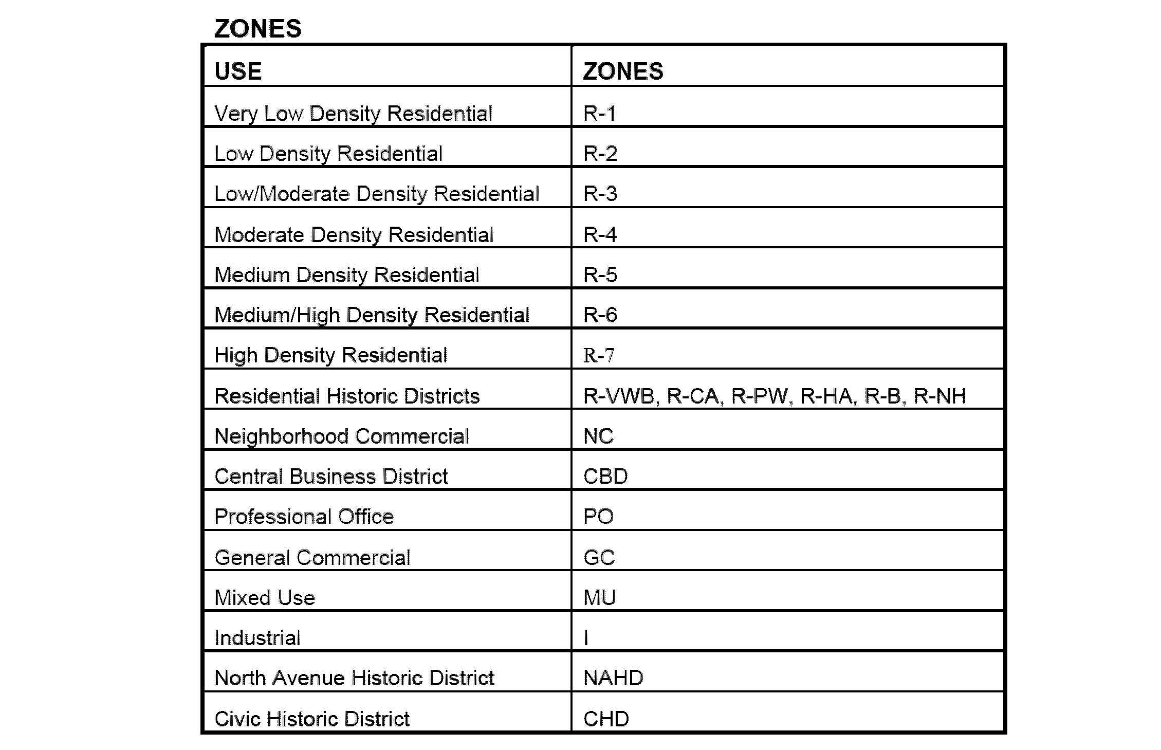
For the purposes of this ordinance, the City of Plainfield is hereby divided into zones differentiated as to use and bulk regulations and to be designated as follows:�
The location and boundaries of each of the above zone districts are hereby established as shown on a map entitled "Zoning Map, City of Plainfield, New Jersey", which map accompanies and is hereby made a part of this ordinance.�
The zone district boundary lines are generally intended to follow street center lines, lot lines as they exist on lots of record at the time of enactment of this ordinance, railroad right of way lines, and stream corridor lines and the like as indicated on the Zoning Map unless otherwise indicated by dimensions of the zoning map. In case of uncertainty or disagreement as to the true location of any zone district boundary line, the determination thereof shall lie with the Board of Adjustment. Any use or structure, including signage, awnings, canopies, newspaper stands or other physical entity proposed within a public right of way requires the approval of City Council.�
Zoning affects all land, structures and uses thereof. Zoning standards, controls and designations apply equally to every lot, structure, and use within each district and the district lines vertically in both directions from ground level. No land or premises may be used and no structure can be erected, raised, moved, enlarged, extended, altered or used for any purpose other than a purpose permitted by this ordinance for the zone district in which the land and structure(s) are located, and all uses and construction shall be in conformity with the regulations provided for the zone district in which such land or structure(s) are located. Any use not expressly permitted is prohibited.�
�
This article establishes the use, bulk requirements and other regulations governing zone districts within the City of Plainfield. Site plan and subdivision design and performance standards set forth in Article XI provide the basis for physical development and redevelopment of land within the zoning classifications.�
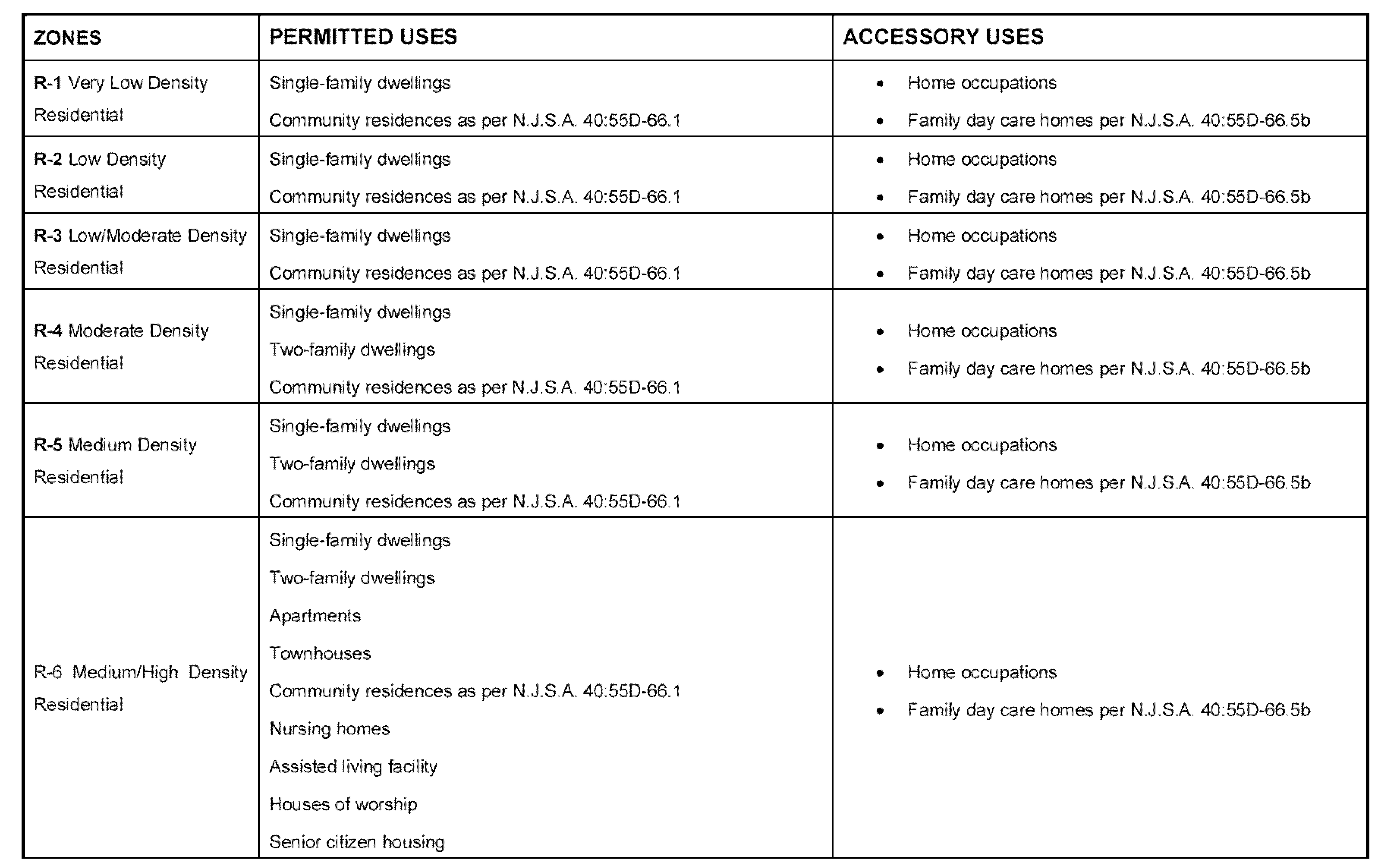
A. Purpose This zone is designed for single family development at a density not to exceed 1.0 dwelling unit per acre.�
B. Permitted uses See Schedule A.�
C. Accessory uses See Schedule A.�
D. Bulk requirements See Schedule B.�
A. Purpose This zone is designed for single family development at a density not to exceed 2.0 dwelling units per acre.�
B. Permitted uses See Schedule A.�
C. Accessory uses See Schedule A.�
D. Bulk requirements See Schedule B.�
A. Purpose This zone is designed for single family development at a density not to exceed 3.5 dwelling units per acre.�
B. Permitted uses See Schedule A.�
C. Accessory uses See Schedule A.�
D. Bulk requirements See Schedule B.�
A. Purpose This zone is designed for single family and two family development at a density set forth in Schedule B not to exceed 5.8 dwelling units per acre for single family dwelling units and 8.7 dwelling units per acre for two family dwelling units.�
B. Permitted uses See Schedule A. �
C. Accessory uses See Schedule A.�
D. Bulk requirements See Schedule B.�
A. Purpose This zone is designed for single family and two family development at a density not to exceed 7.2 dwelling units per acre for single family dwelling units and 8.7 dwelling units per acre for two family dwelling units.�
B. Permitted uses See Schedule A.�
C. Accessory uses See Schedule A.�
D. Bulk requirements See Schedule B.�
A. Purpose This zone is designed for single family, two-family, townhouse and apartment development at a density not to exceed 7.2 dwelling units per acre for single family dwelling units, 8.7 dwelling units per acre for two family dwelling units, 12 dwelling units per acre for apartments and 10 dwelling units per acre for townhouses. at densities set forth in Schedule B�
B. Permitted uses See Schedule A.�
C. Accessory uses See Schedule A.�
D. Bulk requirements See Schedule B.�
A. Purpose This zone is designed for single family, two-family, apartment and townhouse development at a density not to exceed 8.7 dwelling units per acre for single family dwelling units, 11.6 dwelling units per acre for two family dwelling units, 18 dwelling units per acre for apartments and 10 dwelling units per acre for townhouses. at densities set forth in Schedule B�
B. Permitted uses See Schedule A.�
C. Accessory uses See Schedule A.�
D. Bulk requirements See Schedule B.�
A. Purpose This zone is intended to include commercial areas that serve the specific surrounding neighborhoods. The scale and intensity of development should not intrude into but complement the character of the residential neighborhoods they serve.�
B. Permitted uses See Schedule A.�
C. Accessory uses See Schedule A.�
D. Bulk requirements See Schedule B.�
A. Purpose This zone is intended to serve the downtown retail center, as well as a broader, regional population.�
B. Permitted uses See Schedule A.�
C. Accessory uses See Schedule A.�
D. Bulk requirements See Schedule B.�
A. Purpose This zone serves to recognize the existing land use pattern resulting from the conversion of residential housing to professional office space, and to provide standards for professional office development.�
B. Permitted uses See Schedule A.�
C. Accessory uses See Schedule A.�
D. Bulk requirements See Schedule B.�
A. Purpose This zone is intended to include commercial development traditionally associated with high-volume roadways.�
B. Permitted uses See Schedule A.�
C. Accessory uses See Schedule A.�
D. Bulk requirements See Schedule B.�
�
A. Purpose This zone is intended to recognize areas within the City that are developed with retail/commercial uses on the first floor with apartment units above. It is also includes many transition areas within the City, and aims to foster redevelopment by permitting a broad palette of compatible uses. This Zone will also serve as a buffer between commercial districts and lower density residential neighborhoods.�
B. Permitted uses See Schedule A.�
C. Accessory uses See Schedule A.�
D. Bulk requirements See Schedule B.�
A. Purpose This zone calls for industrial and economic development activities.�
B. Permitted uses See Schedule A.�
C. Accessory uses See Schedule A.�
D. Bulk requirements See Schedule B.�
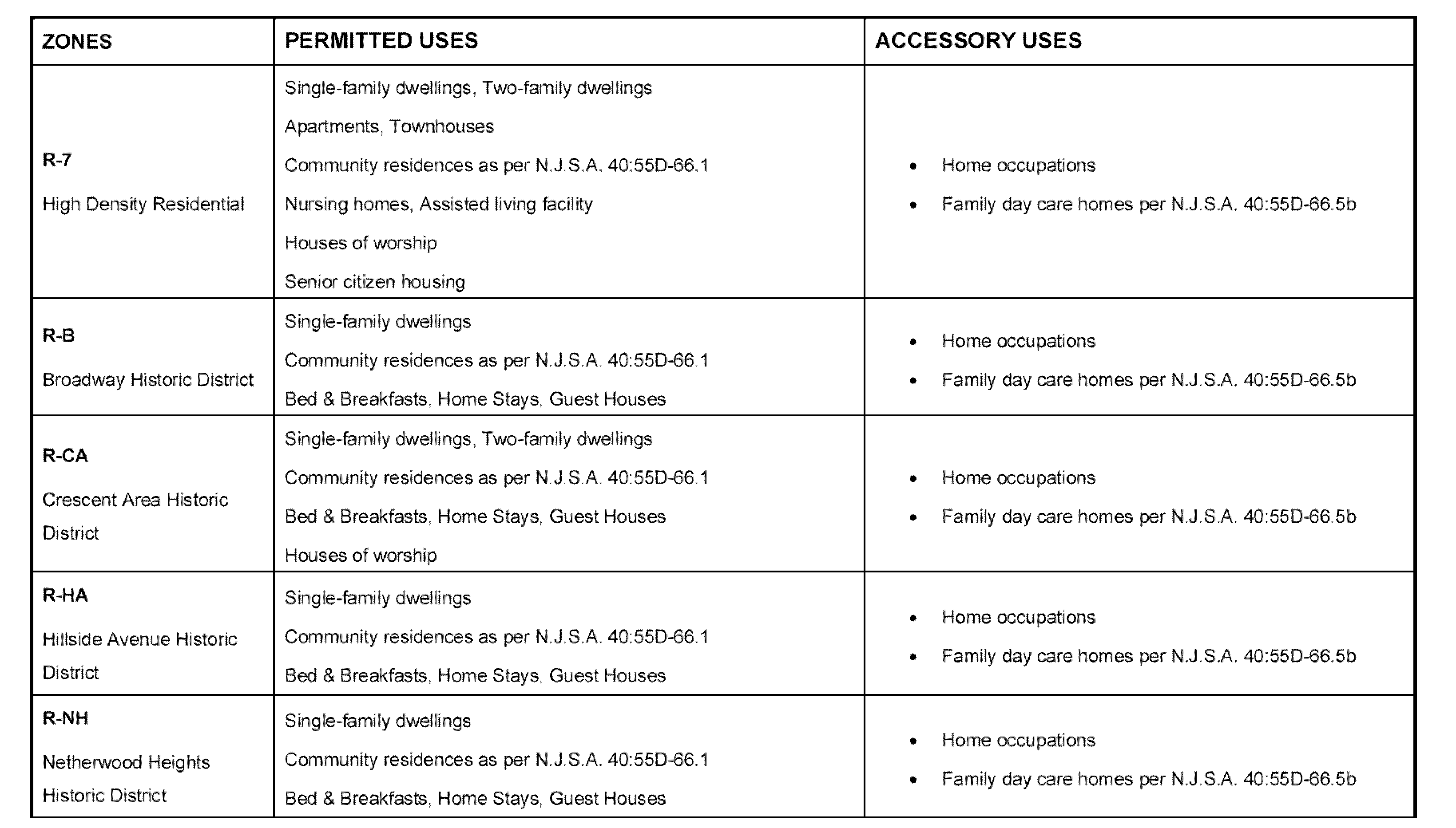
A. Purpose The purpose of the Historic Zone Districts is to recognize and preserve the unique architectural and neighborhood elements present within specific designated historic areas, and to support the preservation of historic structures and design features at densities consistent with historic patterns of development.�
B. Permitted uses See Schedule A. �
C. Accessory uses See Schedule A.�
Bulk requirements See Schedule B.�