
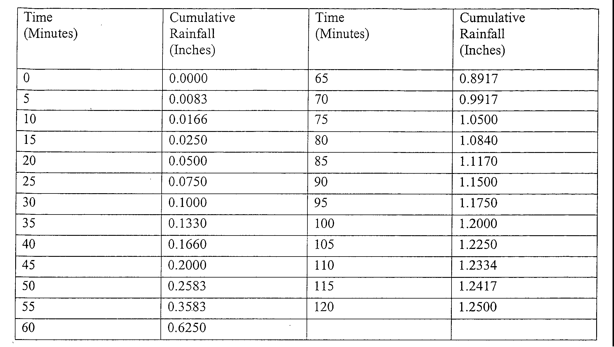
2. For purposes of TSS reduction calculations, Table 2 below presents tile presumed removal rates for certain BMPs designed in accordance with the New Jersey Stormwater Best Management Practices Manual. The BMP Manual may be obtained from the address identified hi § 106-1343, or found on the Department's website at www.njstormwater.org. The EMP Manual and other sources of technical guidance are listed in § 159-7. TSS reduction shall be calculated based on the removal rates for the BMPs hi Table 2 below. Alternative removal rates and methods of calculating removal rates may he used if the design engineer provides documentation demonstrating the capability of these alternative rates and methods in the review agency. A copy of any approved alternative rate or method of calculating the removal rate shall be provided to the Department at the following address: Division of Watershed Management. New Jersey Department of Environmental Protection, PO Box 418 Trenton, New Jersey. 08625-0418.�
3. If more than one BMP in series is necessary to achieve the required 80 percent TSS reduction for a site, the applicant shall utilize the following formula to calculate TSS reduction:�
R.A +/- B - (AXB)/100 �
Where �
R.= total TSS percent load removal from application of both BMPs, and �
A.= the TSS percent removal rate applicable to the first BMP �
B.= the TSS percent removal rate applicable to the second BMP�

4. If there is more than one onsite drainage area, the 80 percent TSS removal rate shall apply to each drainage area, unless the runoff from the subareas converge on site in which case tile removal rate can be demonstrated through a calculation using a weighted average.�
5. Stormwater management measures shall also be designed to reduce, to the maximum extent feasible, the post-construction nutrient load, of the anticipated load from the developed site in stormwater runoff generated from the water quality design storm. In achieving reduction of nutrients to the maximum extent feasible, the design of the site shall include nonstructural strategies and structural measures that optimize nutrient removal while still achieving the performance standards in § 106-134.4.17 and 4.G.�
6. Additional information and examples are contained in the New Jersey Stormwater Best Management Practices Manual, which may he obtained from the address identified in § 159-7.�
7. In accordance with the definition of FW1 at N.J.A.C. 7:93-] .4, stormwater management measures shall be designed to prevent any increase in stormwater runoff to waters classified as FW1.�
8. Special water resource protection areas shall he established along all waters designated Category One at N.J.A.C. 7:9B, and perennial or intermittent streams that drain into or upstream of the Category One waters as shown on the USGS Quadrangle Maps or in the County Soil Surveys, within the associated HUC 14 drainage area. These areas shall he established for the protection of water quality, aesthetic value, exceptional, ecological significance, exceptional recreational significance, exceptional water supply significance, and exceptional fisheries significance of those established Category One waters. These areas shall he designated and protected as follows:�
a. The applicant shall preserve and maintain a. special water resource protection area in accordance with one of the following:�
(1) A 300-foot special water resource protection area shall he provided on eachside of the waterway, measured perpendicular to the waterway from the top of the bank outwards or from the centerline of the waterway where the hank is not defined, consisting of existing vegetation or vegetation allowed to follow natural succession is provided. �
(2) Encroachment within the designated special water resource protection area under Subsection (1) above shah only be allowed where previous development or disturbance has occurred (for example, active agricultural use, parking area or maintained lawn area). The encroachment shall only he allowed where applicant demonstrates that the functional value and overall condition of the special water resource protection area will he maintained to the maximum extent practicable. In no case shall the remaining special water resource protection area be reduced to less than 150 feet as measured perpendicular to the top of batik of the waterway or centerline of the waterway where the bank is undefined. All encroachments proposed under this subparagraph shall he subject to review and approval by the Department.�
b. All stormwater shall be discharged outside of and flow through the special water resource protection area and shall comply with the Standard for Off-Site Stability in the "Standards For Soil Erosion and Sediment Control in New Jersey," established under the Soil Erosion and Sediment Control Act, N.J.S.A. 4:24-39 et seq.�
c. If stormwater discharged outside of and flowing through the special water resource protection area cannot comply with the Standard For Off-Site Stability in the "Standards for Soil Erosion and Sediment Control in New Jersey," established Under the Soil Erosion and Sediment Control Act, N.J.S.A. 4:24-39 et seq., then the stabilization measures in accordance with the requirements of the above standards may he placed within the special water resource protection area, provided that:�
(1) Stabilization measures shall not be placed within 150 feet of the Category One waterway;�
(2) Stormwater associated with discharges allowed by this section shall achieve a 95 percent TSS post-construction removal rate;�
(3) Temperature shall be addressed to ensure no impact on the receiving waterway;�
(4) The encroachment shall only he allowed where the applicant demonstrates that the functional value and overall condition of the special water resource protection area will he maintained to the maximum extent practicable;�
(5) A conceptual project design meeting shall he held with the appropriate Department staff and Soil Conservation District staff to identify necessary stabilization measures; and�
(6) All encroachments proposed under this section shall he subject to review and. approval by the Department.�
d. A stream corridor protection plan may he developed, by a regional stormwater management planning committee as an element of a regional stormwater management plan, or by a municipality through an adopted municipal stormwater management plan. If a stream corridor protection plan for a waterway subject to § 159-4.4G(8) has been approved by the Department of Environmental Protection, then the provisions of the plan shall he the applicable special water resource protection area requirements for that waterway. A stream corridor protection plan for a waterway subject to G-S shall maintain or enhance the current functional value and overall condition of the special water resource protection area as defined in G.8.a. (1) above. In no case shall a stream corridor protection plan allow the reduction of the Special Water Resource Protection Area to less than 150 feet as measured perpendicular to the waterway subject to this subsection.�
e. Paragraph G.8 does not apply to the construction of one individual single family dwelling that is not part of a larger development on a lot receiving preliminary or final subdivision approval on or before February 2, 2004, provided that the construction begins on or before February 2, 2009.�
A. Stormwater runoff shall be calculated in accordance with the following:�
1. The design engineer shall calculate runoff using one of the following methods:�
a. The USDA Natural Resources Conservation Service (MRCS) methodology, including the NRCS Runoff Equation and Dimensionless Unit Hydrograph, as described in the NRCS National Engineering Handbook Section 4 - Hydrology and Technical Release 55 - Urban Hydrology for Small Watersheds; or�
b. The Rational Method for peak flow and. the Modified Rational Method for hydrograph computations.�
2. For the purpose of calculating runoff coefficients and groundwater recharge, there is a presumption that the pre-construction condition of a site or portion thereof is a wooded land use with good hydrologic condition. The term "runoff coefficient" applies to both the NRC'S methodology at § 159-5.A. La and the Rational and Modified Rational Methods at § 159-5.A.1.b. A runoff coefficient or a groundwater recharge land cover for an existing condition may he used on all or a portion of the site if the design engineer verifies that the hydrologic condition has existed on the site or portion of the site for at least five years without interruption prior to the time of application. If more than one land cover have existed on the site during the five years immediately prior to the time of application, the landcover with the lowest runoff potential shall be used for the computations. In addition, there is the presumption that the site is in good hydrologic condition (if the land use type is pasture, lawn, or park), with goad cover (if the land use type is woods), or with good hydrologic condition and conservation treatment (if the land use type is cultivation).�
3. In computing pre-construction stormwater runoff, the design engineer shall account for all significant land features and structures, such as ponds, wetlands, depressions, hedgerows, or culverts that may reduce pre-construction stormwater runoff rates and volumes.�
4. In computing stormwater runoff from all design storms, the design engineer shall consider the relative stormwater runoff rates and/or volumes of pervious and impervious surfaces separately to accurately compute the rates and volume of stormwater runoff from the site. To calculate runoff from unconnected impervious cover, urban impervious area modifications as described in the NRCS Technical Release 55 Urban Hydrology for Small Watersheds and other methods may he employed.�
5. If the invert of the outlet structure of a. stormwater management measure is below the flood hazard design flood elevation as defined at. 7:13, the design engineer shall take into account the effects of tailwater in the design of structural stormwater management measures.�
�
B. Groundwater recharge may he calculated iii accordance with the following:�
1. The New Jersey Geological Survey Report GSR-32A Method for Evaluating Ground Water Recharge Areas in New Jersey incorporated herein by reference as amended and supplemented. Information regarding the methodology is available from the New Jersey Stormwater Best Management Practices Manual; at http://www.state.nj.us/dep/njgs/; or at New Jersey Geological Survey, 29 Arctic Parkway, P.O. Box 427 Trenton, New Jersey 08625-0427; (609) 984-6587.�
A. Standards for structural stormwater management measures are as follows:�
1. Structural stormwater management measures shall he designed to take into account the existing site conditions, including, for example, environmentally critical areas, wetlands; flood-prone areas; slopes; depth to seasonal high water table; soil type, permeability and texture; drainage area and drainage patterns; and the presence of solution-prone carbonate rocks (limestone).�
2. Structural stormwater management measures shall he designed to minimize maintenance, facilitate maintenance and repairs, and ensure proper functioning. Trash racks shall heinstalled at the intake to the outlet structure as appropriate, and shall have parallel bars with one-inch (1") spacing between the bars to the elevation of the water quality design storm. For elevations higher than the water quality design storm, the parallel bars at the outlet structure shall he spaced no greater than one-third (1/3) the width of the diameter of the orifice or one-third (1/3) the width of the weir, with a minimum spacing between bars of one-inch and a maximum spacing between bars of six inches. In addition, the design of trash racks must comply with the requirements of § 106-134.81).�
3. Structural stormwater management measures shall be designed constructed, and installed to be strong; durable, and corrosion resistant. Measures that are consistent with the relevant portions of the Residential Site Improvement Standards at N.J.A.C. 5:21-73, 74, and 7.5 shall be deemed to meet this requirement.�
4.At the intake to the outlet from the stormwater management basin, the orifice size shall he a minimum of two and one-half inches in diameter.�
5.Stormwater management basins shall he designed to meet the minimum, safety standards for stormwater management basins at § 159-8.�
B. Stormwater management measure guidelines are available in the New Jersey Stormwater Best Management Practices Manual. Other stormwater management measures may he utilized provided the design engineer demonstrates that the proposed measure and its design will accomplish the required water quantity, groundwater recharge and water quality design and performance standards established by § 159-4 of this ordinance.�
�
C. Manufactured treatment devices may be used to meet the requirements of § 159-4 of this ordinance, provided the pollutant removal rates are verified by the New Jersey Corporation for Advanced Technology and certified by the Department.�
A. Technical guidance for stormwater management measures can he found in the documents listed at 1 and 2 below, which are available from Maps and Publications, New Jersey Department of Environmental Protection, 428 East State Street, P.O. Box 420, Trenton, New Jersey, 08625; telephone (609) 777-1038.�
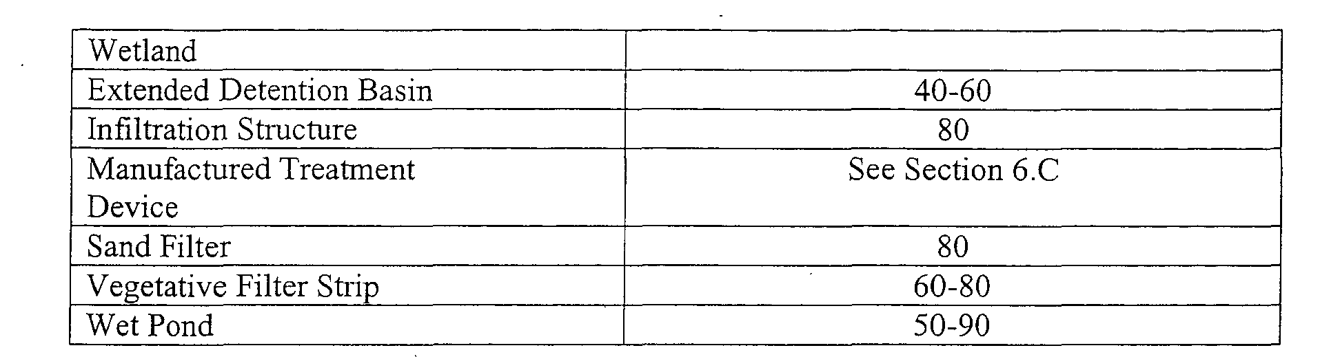
1. Guidelines for stormwater management measures are contained in the New Jersey Stormwater Best Management Practices Manual, as amended information is provided on stormwater management measures such as: bioretention systems, constructed stormwater wetlands, dry wells, extended detention, basins, infiltration structures, manufactured treatment devices, pervious paving, sand filters, vegetative filter strips, and wet ponds.�
2. The New Jersey Department of Environmental Protection Stormwater Management Facilities Maintenance Manual, as amended.�
B. Additional technical guidance for stormwater management measures can he obtained from the following:�
1. The "Standards for Soil Erosion and Sediment Control in New Jersey" promulgated by the State Soil Conservation Committee and incorporated into N.J.A.C. 2:90. Copies of these standards may be obtained by contacting the State Soil Conservation Committee or any of the Soil Conservation Districts listed in N.J.A.C. 2:90-1.3(a)4. The location, address, and telephone number of each Soil Conservation District may he obtained from tile State Soil Conservation Committee, P.O. Box 330, Trenton New Jersey 08625; (609) 292-5540;�
2. The Rutgers Cooperative Extension Service, 732-932-9306; and�
3. The Soil Conservation Districts listed in N.J.A.C. 2:90-1.3(a)4. The location, address, and telephone number of each Soil Conservation District may he obtained from the State Soil Conservation Committee. P.O. Box 330. Trenton, New Jersey 08625, (609) 292-5540.�
A. This section sets forth requirements to protect public safety through the proper design and operation of stormwater management basins. This section applies to any new stormwater management basin.�
B. Requirements for Trash Racks, Overflow Grates and Escape Provisions.�
1. A hash rack is a device designed to catch trash and debris and prevent the clogging of outlet structures. Trash racks shall he installed at the intake to the outlet from the stormwater management basin to ensure proper functioning of the basin outlets in accordance with the following:�
a. The trash rack shall have parallel bars, with no greater than six inch spacing between the bars.�
b. The trash rack shall he designed so as not to adversely affect the hydraulic performance of the outlet pipe or structure.�
c. The average velocity of flow through a clean trash rack is not to exceed 2.5 feet per second under the full range of stage and discharge. Velocity is to be computed on the basis of the net area of opening through the rack.�
d. The trash, rack shall he constructed and installed to be rigid, durable, and corrosion resistant, and shall be designed to withstand a perpendicular live loading of 300 lbs/ft sq.�
2. An overflow grate is designed to prevent obstruction of the overflow structure, if an outlet structure has an overflow grate, such grate shall meet the following requirements:�
a. The overflow grate shall be secured to the outlet structure but removable for emergencies and maintenance.�
b. The overflow grate spacing shall be no less than two inches across the smallest dimension.�
c. The overflow grate shall be constructed and installed to he rigid, durable, and corrosion resistant, and shall he designed to withstand a perpendicular live loading of 300 lbs./ft sq.�
3. For purposes of this paragraph 3, escape provisions means the permanent installation of ladders, steps, rungs, or other features that provide easily accessible means of egress from stormwater management basins. Stormwater management basins shall include escape provisions as follows:�
a. If a stormwater management basin has an outlet structure, escape provisions shall be incorporated in or on the structure. With the prior approval of the reviewing agency identified in § 159-7 a free-standing outlet structure may be exempted from this requirement.�
b. Safety ledges shall he constructed on the slopes of all new stormwater management basins having a permanent pool of water deeper than two and one-half feet. Such safety ledges shall he comprised of two steps. Each step shall be four to six feet in width. One step shall be located approximately two and one-half feet below the permanent water surface, and. the second step shall he located one to one and one-half feet above the permanent water surface. See § 159-8.D for an illustration of safety ledges in a stormwater management basin.�
c. In new stormwater management basins, the maximum interior slope for an earthen dam, embankment, or berm shall not he steeper than 3 horizontal to 1 vertical.�
C. Variance or Exemption from Safety Standards.�
1. A variance or exemption from the safety standards for stormwater management basins may be granted only upon a written finding by the appropriate reviewing agency (municipality, county or Department) that the variance or exemption will not constitute a. threat to public safety.�
D. Illustration of Safety Ledges in a New Stormwater Management Basin.�
A. Submission of Site Development Stormwater Plan.�
1. Whenever an applicant seeks municipal approval of a development subject to this ordinance, the applicant shall submit all of the required components of the Checklist for the Site Development Stormwater Plan at § 159-9c.below as part of the submission of the applicant's application for subdivision or site plan approval.�
2. The applicant shall demonstrate that the project meets the standards set forth in this ordinance.�
3. The applicant shall, submit the number of copies required under § 159-9.c of the materials listed in the checklist for site development stormwater plans in accordance with § 159-9.C of this ordinance.�
B. Site Development Stormwater Plan Approval.�
The applicant's Site Development project shall, he reviewed as a part of the subdivision or site plan review process by the municipal hoard or official front which municipal approval is sought. That municipal board or official shall consult the engineer retained by the Planning and/or Zoning Board (as appropriate) to determine if all of the checklist requirements have been satisfied and to determine if the project, meets the standards set forth in this ordinance.�
C. Checklist Requirements.�
The following information shall he required:�
1. Topographic Base Map.�
The reviewing engineer may require upstream tributary drainage system information as necessary. It is recommended that the topographic base map of the site he submitted which extends a minimum of 200 feet beyond the limits of the proposed development, at a scale of 1" = 200' or greater, showing 2-foot contour intervals. The map as appropriate may indicate the following: existing surface water drainage, shorelines, steel) slopes, soils, erodible soils, perennial or intermittent streams that drain into or upstream of the Category One waters, wetlands and flood plains along with their appropriate buffer strips, marshlands and other wetlands, pervious or vegetative surfaces existing man-made structures, roads, hearing and distances of property lines, and significant natural and manmade features not otherwise shown.�
2. Environmental Site Analysis.�
A.written and graphic description of the natural and man-made features of the site and its environs. This description should include a discussion of soil conditions, slopes, wetlands, waterways and vegetation on the site. Particular attention should. he given to `unique unusual, or environmentally sensitive Features and to those that provide particular opportunities or constraints for development.�
3. Project Description and Site Plan(s).�
A.map (or maps) at the scale of the topographical base map indicating the location of existing and proposed buildings, roads, parking areas, utilities, structural facilities for stormwater management and sediment control, and other permanent structures. The map(s) shall also clearly show areas where alterations occur in the natural terrain and cover, including lawns and other landscaping, and seasonal high ground water elevations. A written description of the site plan and justification of proposed changes in natural conditions may also be provided.�
This plan shall provide a demonstration of how the goals and standards of Sections 3 through 6 are being met. The focus of this plan shall be to describe how the site is being developed to meet the objective of controlling groundwater recharge, stormwater quality and stormwater quantity problems at the source by land management and source controls whenever possible.�
5. Stormwater Management Facilities Map.�
The following information, illustrated on a map of the same scale as the topographic base map, shall be included:�
a. Total area to be paved or built upon, proposed surface contours, land area to be occupied by the stormwater management facilities and the type of vegetation thereon, and details of the proposed plan to control and dispose of stormwater.�
b. Details of all stormwater management facility designs, during and after construction, including discharge provisions, discharge capacity for each outlet at different levels of detention and emergency spillway provisions with maximum discharge capacity of each spillway.�
6.Calculations.�
a. Comprehensive hydrologic and hydraulic design calculations for the predevelopment and post-development conditions for the design storms specified in 106-134.4 of this ordinance.�
b. When the proposed stormwater management control measures (e.g., infiltration basins) depends on the hydrologic properties of soils, then a soils report shall be submitted. The soils report shall be based on onsite boring logs or soil pit profiles. The number and location of required soil borings or soil pits shall he determined based on what is needed to determine the suitability and distribution of soils present at the location of the control measure.�
7. Maintenance and Repair Plan.�
The design and planning of the stormwater management facility shall meet the maintenance requirements of § 159-10.�
8. Waiver from Submission Requirements.�
The municipal official or hoard reviewing an application under this ordinance may, in consultation with the municipal engineer, waive submission of any of the requirements in §106-134.9C.1 through 9.C.6 of this ordinance when it can he demonstrated that the information requested is impossible to obtain or it would create a hardship on the applicant to obtain and its absence will not materially affect the review process.�

