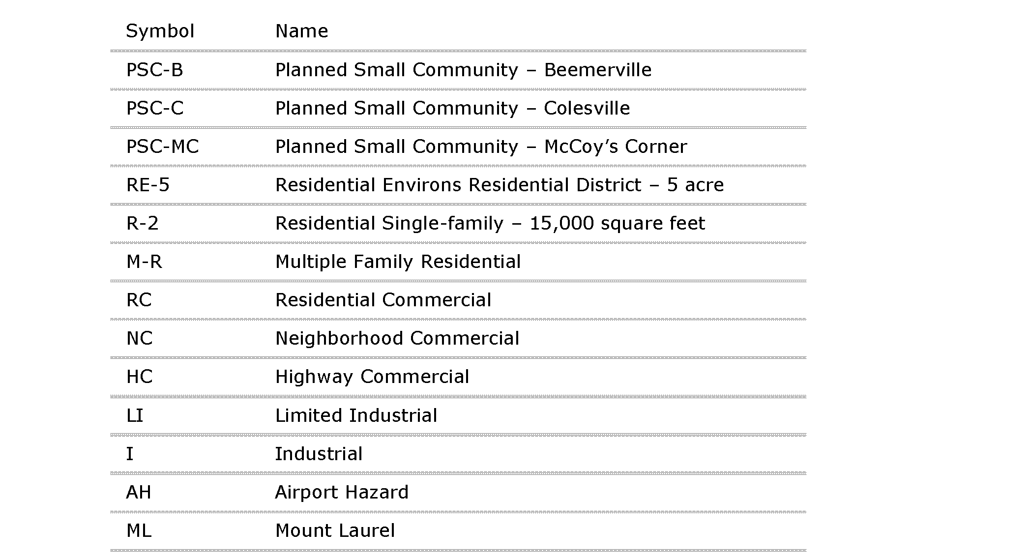
For the purpose of this chapter Wantage Township is hereby divided into use districts as follows:

**Webmasters Note: The previous section has been amended as per Ordinance No. 2006-09.
a The boundaries of the Zone Districts described in section13-3.1 are hereby established as shown on a map entitled ''Zoning Map of the Township of Wantage'' last revised ____________ prepared by Harold E. Pellow & Associates of Augusta New Jersey and dated _____________, which map accompanied and was declared to be part of this ordinance as amended from time to time by ordinance and now the attached ___ 2006 revision to said map is herewith made a part of this section.
**Webmasters Note: The previous subsection has been amended as per Ordinance No. 2006-
09.
b Amendments to zoning map Beginning at art iron pipe found at the common back corner of Tax Lots 10 and 11 Block 14 as shown on the current Wantage Township Tax Map Said won pipe is at an angle point in the zone line between the highway commercial zone and the residential zone as shown on the Wantage Township Zoning Map
Said iron pipe also marks the sixth corner of a 43, 628 acre tract of land conveyed by Helen E Sprague and others to Robert J Mankovich and Shirley Mankovich, his wife by deed dated November 7, 1969 and recorded in the Sussex County Clerks Office in Deed Book 86 1, Page 899 etc
Thence running from said beginning along a new division line through lands of said Mankovich north 35 degrees, 54 minutes 30 seconds west 544 59 feet to a point in the division line between lands of said Mankovich and lands of Theodore Holbert said point being distant 367 11 feet on a bearing of south 28 degrees, 27 minutes. 30 seconds west from the common front corner of Tax Lots 13A and 15, Block 14 as shown on the current Wantage Township Tax Map
It is intended that all lands owned by said Mankovich lying on the southeasterly side of the above described line become a part of the highway commercial zone
The municipal clerk is hereby directed to give notice at least ten days prior to the hearing and adoption of this ordinance to the county planning board and all others entitled thereto pursuant to the provisions of N J S A 40 55D- 15 Upon adoption of this ordinance after public hearing thereon the municipal clerk is further directed to publish notice of the passage thereof and file a copy of this ordinance as finally adopted with the Sussex County planning Board as required by NJ S A 40 55D- 16
c pursuant to the Air Safety and Hazardous Zoning Act of 1983 P L 1983, c 260, N J SA 6 1-80 et seq. and N J A C 16 62-1 1 et seq. there is hereby established an airport hazard zone district on the zoning map of the Township of Wantage The airport hazard district consists of a runway subzone and two runway end zones The shape of this zone district and the subzones are shown on the zoning map of the Township of Wantage
d Along the westerly side of State Route 23 from its intersection with Cemetery Road to County Route 565 for a depth of feet in a westerly direction from the westerly right of way line of State Route 23
e Lots 2 and 4 01 all in Block 53, and situate between Smith Road and Sherman. Ridge Road currently designated highway commercial shall be changed to R- 1
District boundary lines are intended to follow street center lines and lot or property lines as they exist on January 1979 unless otherwise indicted by dimensions on the zoning map The exact location of any disputed district boundary line shall be determined by the board of adjustment
Where a vacated right-of-way is bounded on either side by more than one district the former center line of such right-of-way shall become the new district line