A. VALIDITY
Each clause, section, paragraph, subdivision or article of this Ordinance shall be deemed a separate provision to the intent that if any such clause, section, paragraph, subdivision or article should be declared invalid, the remainder of this Ordinance shall not be affected.
B. CONTINUANCE OF EXISTING APPLICATIONS FOR DEVELOPMENT
All applications for development filed prior to the effective date of this ordinance shall be continued, but any appeals arising from decisions made on any such application shall be governed by this ordinance.
C. COPY TO BE FILED WITH COUNTY PLANNING BOARD
Immediately upon adoption of this ordinance, the Township Clerk shall file a copy of this ordinance with the County Planning Board as required by law. the Township Clerk shall also file with the said County Planning board copies of all other ordinances of the municipality relating to land use.
D. REPEAL OF INCONSISTENT ORDINANCES
All ordinances or parts of ordinances, including An Ordinance to limit and restrict to specified districts or zones or to regulate therein, buildings and structures, according to their construction and the nature and extent of their use in Franklin Township, Somerset County, New Jersey, originally adopted August 8, 1940, all amendments and supplements thereto, and An ordinance establishing rules, regulations and standards governing the subdivision of land within the Township of Franklin pursuant to the authority set forth in C. 40:55D-1 et seq, and amendments and supplements thereof: setting forth the procedure to be following by the Planning Board in apply and administering these rules, regulations and standards; and providing penalties for the violation thereof,, which are inconsistent with this ordinance are hereby repealed.
E. EFFECTIVE DATE
This ordinance shall take effect immediately upon adoption and publication according to law, and filing with the County Planning Board in accordance with C. 40:55D-1 et seq.
A. PAYMENT TO ADMINISTRATIVE OFFICER; PRE-REQUISITION TO APPROVAL
(1) All fees as hereinafter required shall be payable to the administrative officer at the time of filing any application for development, provided however, that fees required for matters relating to the Township Council shall be payable to the Township Clerk.
(2) All permits, determinations, resolutions or certificates of approval are subject to the payment of all fees provided for in this chapter, and no approvals shall be given by the Planning Board or Board of Adjustment until proof has been submitted to them that the requisite fees have, in fact, been paid to the administrative officer.
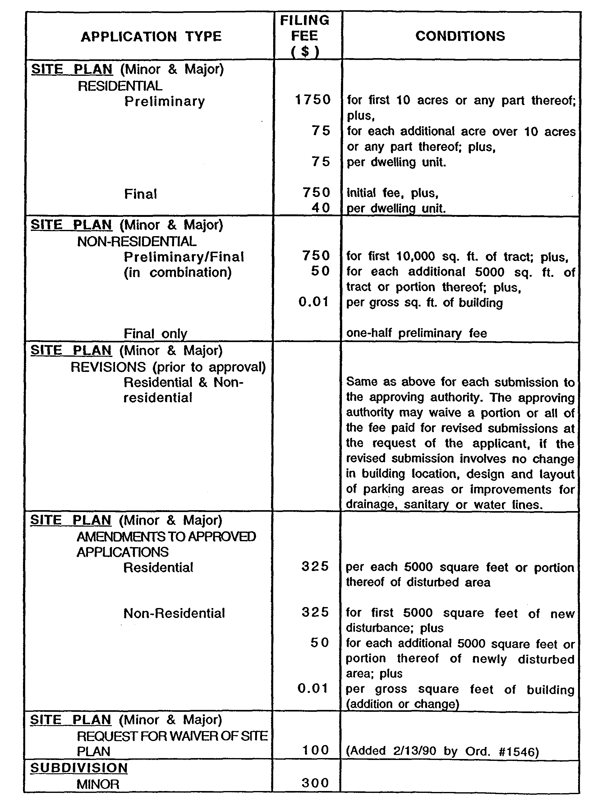
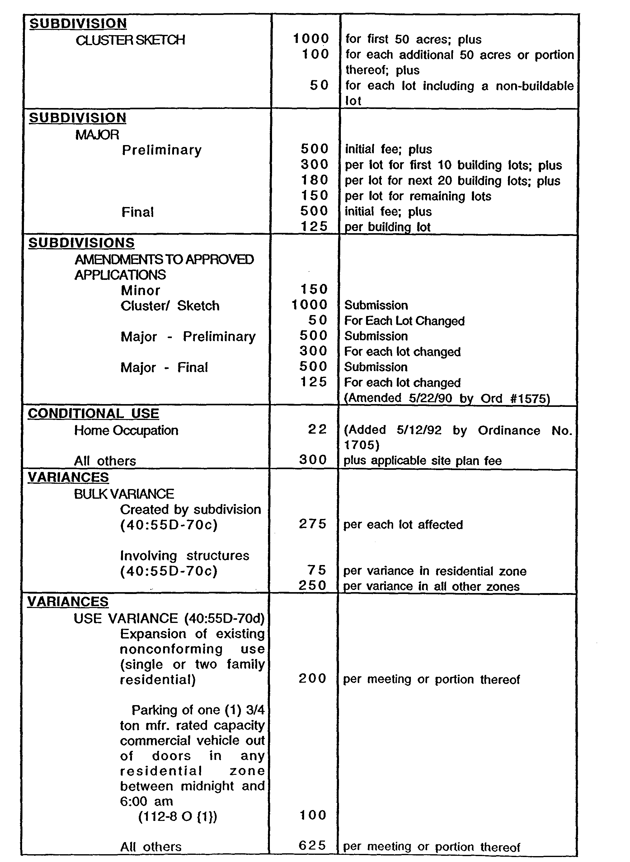
B. SCHEDULE OF FEES
All developers or appellants to the Planning Board, Board of Adjustment, Construction Official, Township Engineer or Township Council shall pay the applicable fees in accordance with Schedule VI.
C. WAIVER OF FEES
Fees required pursuant to Section 112-38B shall be waived for all nonprofit organizations.
D. TAX MAP AND GEOGRAPHIC INFORMATION SYSTEM (GIS) MAINTENANCE, FEES.
1. The following fees shall be paid by the applicant at the time of adoption of a resolution of subdivision or site plan approval by the Municipal Planning Board or the Board of Adjustment if Franklin Township for the cost of making upgrades and modifications to the tax mane and geographic information system (GIS) of Franklin Township relating to said applications. These fees are subject to modification ac needed by adoption of a Resolution of the Township Council.
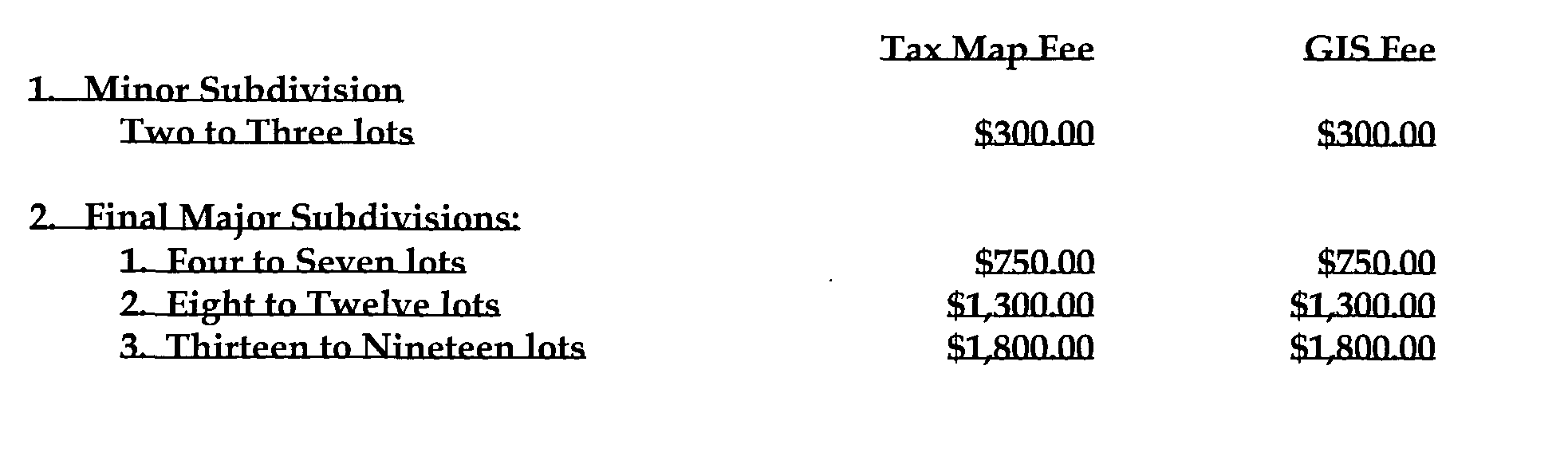
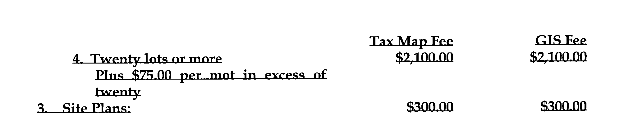
2. Payments by escrow fees required hereunder shall be an expressed condition of any subdivision or cite plan approval granted by the Franklin Township Municipal Planning Board or Board of Adjustment.
3. At the time the Final Plat is submitted for signature of the Municipal Official Applicant shall submit a CAD-generated data file(s) prepared by a New Jersey Licensed Land Surveyor, directly translatable into an identical image of the File Map. The file shall be transmitted on a standard 3.5," floppy click or standard compact disk.
4. The format shall be either
A. A CADD drawing or
B. An ASCII Drawing Interchange File (i.e. a "DXF" Extension file) compatible with AutoCAD release 13 or later.
5. All required information shall appear on separate layers of the drawing
6. Text shall also appear on a separate layer of the drawing
7. The file most he drawn at its real New Jersey Plan Coordinates NAD93 (or the most current State Plane coordinate system) position and the view must he unrotated so that the NJPCS North points orthographically up (vertical) in the screen. The drawing shall identify at a minimum? three (3) monument markers distributed around the corners of the tract. These monument markers shall hp identified in US Survey Feet.
8. The information required in the data file(s) shall be:
A. All required information submitted on the final plat shall appear state layers of the drawing.
B. The location of all existing and proposed signage and catch basins, to be given as a layer in the CADD drawing.
C. The location of all existing and proposed culverts., given as the center of the structure at the centerline of the roadway to be given as a layer in the CADD drawing.
D. The data file(s) shall contain any site description information as required by the Franklin Township Municipal Planning Board or Board of Adjustment. This data includes site description information shown on the Preliminary Plan and/or Site Plan and any data given by the Applicant after initial plans are submitted. Site description information shall include the following information as deemed applicable by the Franklin Township Municipal Planning Board:
Wetlands
Marshes, ponds, lakes
Vegetated areas
Endangered species habitats
Steep slopes
Flood plains
Conservation Easement and Open Space
Streams and stream corridors
Distinctive scenic and/or historic features
9. At the discretion of the Applicant, the Municipal Surveyor who maintains the Tax Map can be requested to do the required conversion to CAS based on those hourly fees listed in the Surveyor's Annual Professional Services Agreement.
**Webmasters Note: The previous section has been added as per Ordinance No. 3560.