The foregoing sites could be in various stages of property remediation. Examination of the case files is necessary. Environmental Assessments of other existing and former commercial and industrial properties are necessary to determine the potential for contamination on such properties.
5. Area Development Projects
Several of the development projects recommended in the 1995 plan for the Renaissance 2000 area are currently being implemented, either through design or construction. The projects are as follows:
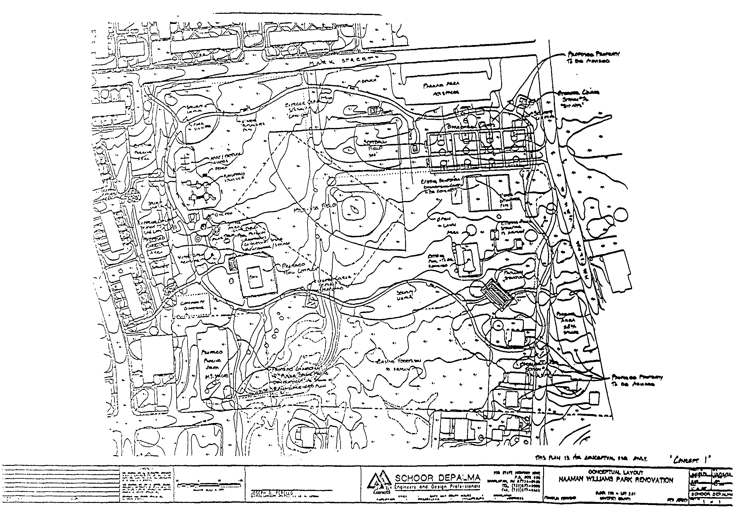
a. Naaman Williams Park Improvements
It has been an on-going recommendation of Renaissance 2000 to upgrade and expand Williams Park to meet changing community needs. The Township is currently pursuing the recommendations and has retained a consultant to prepare a concept plan for the redesign of the park. A preferred concept plan (see Concept 1) has been selected, and will be modified to contain an expanded pavilion and tennis courts. The concept plan includes the following:
(1) the provision of off-street parking for the adjacent Park-side community,
(2) upgrade of the community pool
(3) multi-use and softball fields
(4) basketball and tennis courts
(5) a fitness circuit path and tot lot
b. First Baptist Church Expansion
Another recommendation of Renaissance 2000 was the expansion of the First Baptist Church and parking area. The expansion is currently underway and will increase the capacity of the church and the parking area.
C. Parkside Street Realignment
d. Other Projects
The Plan is sensitive to current revitalization efforts in the Area and supports any current efforts that are consistent with the goals and standards of this Plan. One development application has been identified as having either Board approval or is under construction in or adjacent to the Area:
(1) Jumab Pharmacy - A proposed pharmacy on Block, 130, Lots 5-11 received final site plan approval from the Franklin Township Planning Board in April 1997 and is currently under construction. The principal structure will have 3,560 square feet of gross floor area, will be one (1) story in height, and will access Fuller Street. The property dedicate eight (8) feet of its Franklin Boulevard owner will I frontage to Somerset County for right-of-way purposes.
(2) Utilities Infrastructure
The Redevelopment Area is highly suitable for development due to its location along Route 27 and its existing roadway and utilities infrastructure. Utilities available in the Redevelopment Area include public water and stormwater infrastructure, public sewerage, subsurface gas, and aboveground electricity, telephone, and television cable service. The water and sewerage lines are owned and maintained by Franklin Township. Gas and electric service is provided by PSE&G, telephone service by Bell Atlantic-NJ and television cable by TKR Cable. These utilities are located in the roadway right-of-way. According to Township officials, the water, stormwater and sewerage lines are adequate to meet the needs of future commercial operations. Eight-inch diameter water mains are located along Route 27 and Frank-tin Boulevard in the area. Six-inch water distribution lines service the adjacent streets. Domestic water is provided by the Elizabethtown Water Co., and sanitary wastes are collected by the Middlesex County Utilities Authority.
(3) Roadway Infrastructure
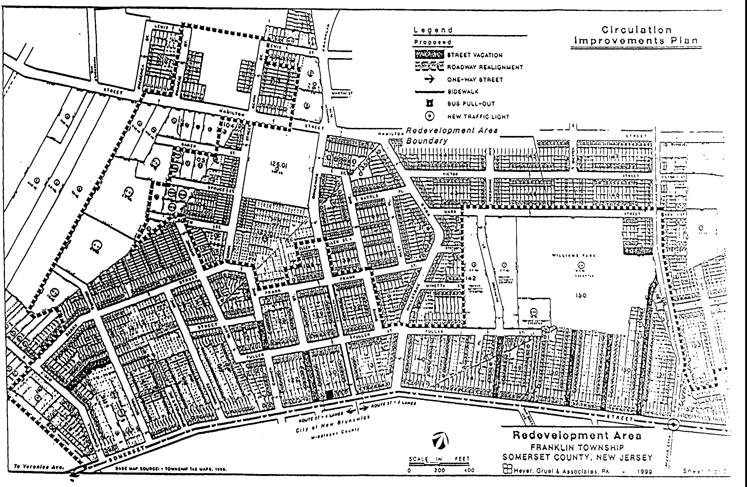
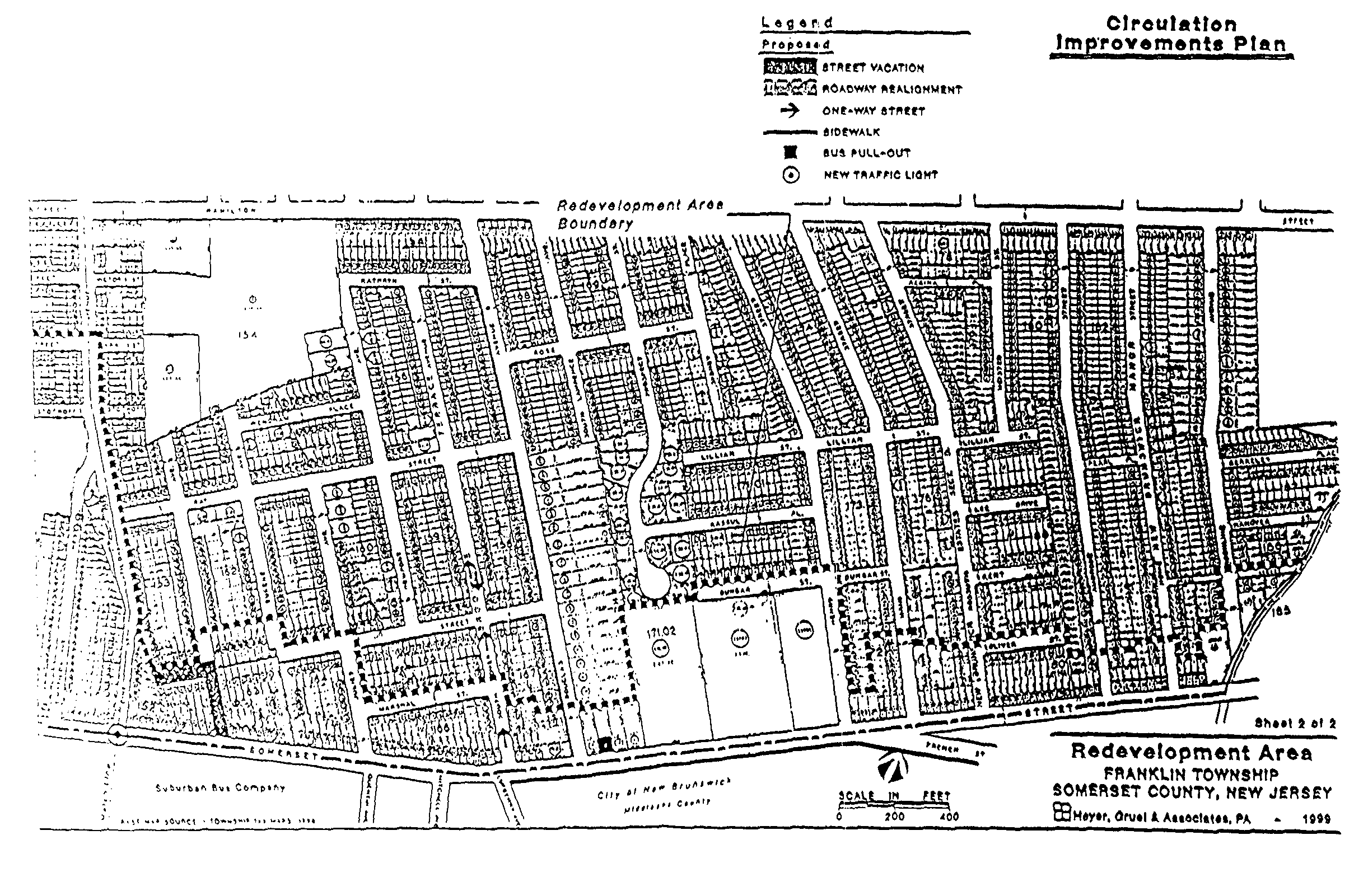
Route 27/Renaissance 2000 Corridor Study Route 27 is an undivided four-lane State highway with no shoulders that has sidewalks on either side for the majority of its length in the Area. Route 27 is characterized by heavy traffic volumes, particularly in the southern portion of the roadway in Franklin and New Brunswick and is the host of above-average accident, specifically pedestrian, levels. In the Renaissance 2000 area, Route 27 is heavily traveled and is perceived to be pedestrian unfriendly at best. Traffic volumes during the evening peak hour have been recorded at 2,250 vehicles at the intersection of Route 27 and Franklin Boulevard, which increases as one moves southward to 2,864 vehicles at the intersection of Route 27 and Veronica Avenue and decreases as one moves northward to 1,595 vehicles at the intersection of Route 27 and French Street in New Brunswick. NJDOT recently sponsored a study of the Route 27 corridor in and around the Renaissance 2000 area which recommends functional, safety and aesthetic improvements throughout the area. Conceptual recommendations were presented and discussed with stakeholders in the Renaissance 2000 area, including representatives of Franklin Township. The stakeholders support the recommendations as presented (see Resolution from Township Council in Appendix A). The goal of the study recommendations is: To improve the ability of Renaissance 2000 area residents to safely travel within the area and access destinations outside the area; to improve access to commercial and work destinations within the Route 27 corridor; and to maintain regional mobility for thorough traffic, while preventing such traffic from impairing the quality of life for Renaissance 2000 residents. (Route 27/Renaissance 2000 Corridor Study, May 1999) The study recommends both aesthetic and circulation improvements, including the promotion of pedestrian and bicyclist safety and increased linkages with the existing bus lines and bus station on Route 27. The following improvements are recommended:
(4) Roadway Improvements:
From French Street to Franklin Boulevard - 2 travel lanes with a center turning lane (instead of four travel lanes) is proposed. The right-of-way will accommodate a 4-foot wide sidewalk and a 5-foot wide panel for grass and/or shade tree plantings. A 4.5-foot wide shoulder/bike lane will be provided on both-sides of the street. There is also the opportunity for special paving at left-turn locations and along pedestrian crosswalks.
From Franklin Boulevard to How Lane - 4 travel lanes with a center shared left turn lane are proposed. Driving lanes will be gradually increased between Irving Street and Franklin Boulevard so that 4 lanes are achieved west of Franklin Boulevard. The right-of-way will accommodate a 4-foot wide sidewalk and a 3-foot wide panel for grass planting. A 3-foot wide shade tree easement will be obtained on the outside of the sidewalk area for shade tree plantings. A 5-foot wide shoulder/bike lane will be provided on both sides of the street.
Public Transportation Improvements: Locations for bus pull-out areas (areas recessed into the roadway right-of-way) have been identified in Franklin at the Franklin Boulevard and Route 27 intersection and at the Douglas Avenue and Route 27 intersection In the Redevelopment Area.
Pedestrian Improvements:
Sidewalk construction is proposed for the following roadways in the Redevelopment Area:
Both sides of Franklin Boulevard from Route 27 to Frank Street
Both sides of the new Matilda Avenue From Route 27 to Hamilton Street
The west side of Douglas Avenue from Route 27 to Kathryn Street
The concept plan proposes installing a pedestrian light at the intersection of new Matilda Avenue and Route 27 to connect the senior housing site in Franklin with the Suburban Bus Lines bus station in New Brunswick.
The City of New Brunswick has indicated that it will receive grant money to install sidewalks along Route 27 in the vicinity of St. Peter's Cemetery.
The study recommends that the 'intersection of French Street and Route 27 be studied in greater detail to determine potential safety improvements in that area.
County
Franklin Boulevard (CR 617) Is a four-lane roadway with a 50-foot right-of-way in the Redevelopment Area, which connects Route 27 with Easton Avenue in (lie Township. width is currently 44 feet the Redevelopment
Pavement
Area. No sidewalk is currently provided along this roadway in the Redevelopment Area. The installation of sidewalks along this roadway from Route 27 to Frank Street is recommended in the Route 27/Renaissance 2000 Corridor Study prepared for NJDOT. Somerset County currently has no plans to alter/improve this road in the Redevelopment Area.
Hamilton Street (CR 514) is a four-lane roadway with a 66-foot right-of-way in the Redevelopment Area. Sidewalks are in place on the northern side of Hamilton Street in the Area.
Local Roadway
The local roadways in the Redevelopment Area have 50 foot-wide right-of-ways with 27+ feet of pavement width. These local roadways are generally not striped or curbed and do not contain sidewalks in most locations. The 1995 Renaissance 2000 plan proposed several local street closures to decrease turning movements onto Route 27 and to discourage residential through-traffic. In most cases, the effect of the closures can be achieved through more efficient measures, as will be detailed in the Circulation Plan section of the Plan.
Additionally, there are Several paper streets within the Redevelopment Area that are indicated on the Township tax maps but are currently unimproved. They are:
Myrtle Avenue
Marshal Street
Gurley Street
F. PLAN GOALS
In general, the Plan attempts to improve the Redevelopment Area by providing locations and design standards for uses that are currently in demand that will increase job and housing opportunities and community pride in the Area. The specific goals of the Plan, in a non-prioritized order, are as follows:
1. To promote the effective use of all the Redevelopment Area property and to improve property values within the area to increase local revenues.
2. To direct redevelopment to promote neighborhood pride and activism through job opportunities and aesthetic improvements.
3. To improve utilization of land in the Redevelopment Area, which, by virtue of its proximity to transportation and major employment and population centers, could be more effectively employed for the community benefit.
4. To foster existing partnerships and to establish new ones, where appropriate.
5. To acknowledge the significance of State Route 27 to the area, and to capitalize on its presence while not exceeding the capacity of local roads within or beyond the Redevelopment Area.
6. To improve circulation on Route 27 and local or County roadways white providing for enhanced, safe pedestrian and bicycle circulation.
7. To improve the appearance of the Route 27 corridor to provide a positive community identity
8. To coordinate design standards with the City of New Brunswick-portion of the Renaissance 2000 area to create a consistent aesthetic appearance throughout the Renaissance 2000 area.
9. To create a circulation pattern that will serve the planned uses in the area and that will protect cohesive residential areas from through-traffic.
10. To improve the public elements of the streetscape through landscaping, street furniture, paving, lighting and pedestrian linkages.
11. To provide a variety of housing types for all age groups that will be affordable to those living in the area.
12. To preserve and upgrade existing, stable residential areas.
13. To improve Naaman Williams Park to serve a broader range of age groups with a variety of facilities and programs sponsored by public schools, churches, other human services agencies and local residential organizations.
14. To incorporate the goals and plans of the property owners to the greatest extent possible in a manner consistent with the Plan.
15. To create Special Improvement Districts or Business Improvement Districts In appropriate locations.
16. To promote the creation of high-quality in the Township that will provide opportunities for both existing residents and as well as for others in the region.
17.To improve local entrepreneurial opportunities through promotion of new and diverse economic activities.
18.To maximize the leveraging of public and private funds to accomplish comprehensive redevelopment of the area.
19.To redevelop land occupied by obsolete structures or uses.
G. DEVELOPMENT OPPORTUNITIES
The Redevelopment Area in Franklin Township presents many development opportunities due to its location, the resident population base, the high volumes of through-traffic and most importantly due to the united efforts of residents, property owners, business owners, community-based groups and governmental entities.
The Plan calls for the following elements:
1. Opportunity for independent, affordable Senior Housing, an affordable Assisted-Living Facility, a day care center and generation of associated job opportunities.
2. Improvement of Naaman Williams Park to contain more parking and recreation features in a safer environment.
3. Increased local retail and office entrepreneurial opportunities through the construction of new retail and office space.
4. Infill of existing, stable residential areas with new residential uses.
5. Infill of existing commercial and light industrial areas with new uses and implementation of new design standards.
6. Improvement of the physical appearance of the Area through new design standards, the implementation of new uses and Streetscape requirements.
7. Public street improvements to upgrade the road network's safety and circulation for pedestrians and bicyclists as well as automobiles.
H. CIRCULATION PLAN
In order to meet the goals of the Plan and to accommodate planned development, improvements to the existing roadway network in the Redevelopment Area are required (see Circulation Improvements Plan).
1. Route 27
The recommendations of the Route 27/Renaissance 2000 Corridor Study have been endorsed by the Renaissance Neighborhood Association and the 1999 Franklin Township Council, and are endorsed by this Plan. At this time, they include:
Lane reconfiguration changes north and south of Franklin Boulevard
Pavement markings or other measures including, cross walks to promote safety and aesthetics along Route 27
Installation of a stop light with pedestrian timing at the intersection of newly aligned Matilda Street (Pine Street) and Route 27
Installation of bus pull-outs and bus shelters along Route 27
Addition of shoulders as shared bicycle lanes
Provision of right-of-way or casement for street tree plantings
Further study of the French Street/Route 27 Intersection in terms of pedestrian safety
2. Realignment of Irving Street
As an alternative to the realignment of Parkside Street to Van Dyke Avenue in New Brunswick, it was recommended by FBCDC that the realignment of Irving Street to Van Dyke Avenue may be a more beneficial alignment in terms of lesser neighborhood impacts and In terms of engineering. This alternative is recommended for further study, and is part of the grant monies sought from Somerset County alternative to the Parkside Street realignment.