
6.acres and larger - in accordance with A standards.
F. PRESERVATION AREA
(1) No less than forty (40%) percent of the entire tract shall be designated as Preservation Area.
(2) The Preservation Area shall have a minimum contiguous lot area of not less than 15 acres and no portion thereof shall be less than 500 feet in width except, however, the Planning Board may allow the creation of a Preservation area less than 15 acres or less than 500 feet in width as may be reasonable and within the general purpose and intent of the ordinance if the literal enforcement of the provisions of this subsection is impractical or will exact undue hardship because of peculiar conditions pertaining to the land in question.
(3) Preservation Areas shall first be made available for the benefit of all residents of the Township, and accordingly shall be offered for dedication to the Township or its designee. The applicant shall deed all Preservation Areas to the Township upon final approval and prior to the commencement of any construction or the issuance of any building permits by the Township for work on the site. Prior to the dedication to the township or its designee, the lands shall be improved by the Developer in accordance with Township requirements. Improvements to the property may include but are not limited to development of the site for its natural and scenic qualities, including the removal of all debris by the applicant, the establishment of trails or other means to view the site, or to connect the site to other Preservation Areas or similar areas, landscaping or other measures to improve the environmental characteristics of the property. The Environmental Commission shall provide a list of all recommended improvements, all or any of which may be incorporated into any preliminary and final approvals at the discretion of the Planning Board. Improvements to the site may also include recreational facilities, provided they are approved by the Township Council upon a recommendation from the Planning Board and/or as recommended in the Township Master Plan. [Amended 6/12/01 by Ord No. 3223]
(4) If all or a portion of the property designated a Preservation Area is not accepted to public use, or if the approving agency shall determine only a portion thereof be accepted to public use, said areas not so accepted to public use shall be protected by legal arrangements, satisfactory to the Planning Board, sufficient to assure its maintenance and preservation for its intended purpose. Covenants and other legal arrangements shall specify ownership of the area; method of maintenance; responsibility for maintenance; maintenance taxes and insurance; compulsory membership and compulsory assessment provisions; guarantees that any association formed to own and maintain said area will not be dissolved without the consent of the Planning Board; and any other specifications deemed necessary by the Planning Board. [Amended 6/12/01 by Ord. No. 3223]
(5) Preservation Areas shall not be approved to include facilities necessary for approval of construction of the developed portion of the property including but not limited to drainage basins. [Added 6/12/01 by Ord. No. 3223]
(6) All tracts of land deeded to the Township designated as a Preservation Area shall be deed restricted and contain specific notation reflecting that the property was acquired for preservation and is subject to all conditions and restrictions of such designation. No building, real property or interest therein acquired as part of the NRPC Ordinance shall be sold, conveyed, leased or otherwise alienated from Township ownership, unless it has been approved by the Township Council after review by and comment from the Planning Board' Agricultural Advisory Committee, Environmental Commission and Open Space Advisory Committee. [Added 6/12/01 by Ord. No. 32231
G. FINDINGS [Amended 6/2/01 by Ord. No. 3223]
The Planning Board shall determine, at a minimum, the following findings with respect to the proposed NRPC application:
(1) The development provides for a total environment better than that which could be achieved under conventional subdivision.
(2) The application conforms to the Comprehensive Plan of the township.
(3) The application is designed to produce an environment of stable and desirable character, consistent with the intent and purpose of the cluster development regulations. to promote public health, safety and general welfare, and not out of harmony with its surrounding neighborhood.
(4) The property would be used for purposes and in a manner permitted in the. existing district except for lot size, and site of dwellings in the zone.
(5) The Conservation Plan has been submitted to the Agricultural Advisory Committee, Environmental Commission, the Shade Tree Commission and the Open Space Advisory Committee for review and comment and is in accordance with the standards set forth in the ordinance. [Added 6/12/01 by Ord. No. 3223]
H. APPLICATION
(1) An applicant proposing to develop lands in accordance with the above conditions shall first submit a sketch subdivision plat to the Planning Board in accordance with standards enumerated in Section 112-12 et seq of this Ordinance. After approval of the plat by the Planning Board, the applicant may then submit a plan in accordance with the standards and conditions of Section 112-91) and Section 112-10 et seq.
(2) An NPRC application accompanied by a Sketch Plat in conformity with Section 112-12C shall further contain the following:
(a) A designation of those portions of the combined tract intended for residential cluster development and the development densities proposed (the "Development Areas");
(b) Projects in excess of 500 acres shall not be required to designate lot layouts on the sketch plat.
(3) In addition, the Applicant shall also submit a Conservation Plan in accordance with the following standards:
(a) A Conservation Plan for all Preservation Areas within the total project shall be provided. Such a Conservation Plan shall include the location, size, nature and topography of all Preservation Areas.
(b) The Conservation Plan shall describe in a written report any irreplaceable natural resource features located on the tract, such as but not limited to stream corridors, headwaters of streams, wetlands, ponds or lakes; wildlife habitats; forests, significant stands of trees, hedgerows and individual trees of significant size; farmland; significant viewsheds and ridgelines; rock outcroppings, including the bluffs or cliffs along Canal road and the Delaware & Raritan Canal State Park. These irreplaceable natural features shall be included within Preservation Areas to the maximum extent practicable. All trees or forests with trees greater than 18 inches in diameter shall be separately identified on the Conservation Plan. [Amended 6/12/01 by Ord. No. 32231
(c) If any Preservation Areas within the Conservation Plan are slated for preservation because of scenic value and purposes, their suitability shall be determined by visibility from a roadway and/or visibility to a significant number of people.
(d) The Conservation Plan shall describe existing structures or sites having significant historic or social value to the Township. Such historic structures and sites shall be preserved to the maximum extent practicable.
(e) The Conservation Plan shall describe how Preservation Areas are protective of the environment and wildlife and shall demonstrate how Preservation Areas support the goals and intent of the Comprehensive Plan of the Township and of this ordinance.
(f) All Preservation Areas within the Conservation Plan shall be designed to be compatible with the submitted Cluster Development proposal, as well as with existing development in the immediate area.
(g) The applicant shall meet with the Environmental Commission and provide a copy of the Conservation Plan prior to any preliminary approvals by the Planning Board. The Environmental Commission shall review the Conservation Plan and make any proposed changes to it which will enhance the public's ability to enjoy the property. The Planning Board shall review the comments of the Environmental Commission and may incorporate these changes into the approved Conservation Plan if it determines the proposed changes are in the best interests of the public. [Added 6/12/01 by Ord. No. 3223]
(h) The Planning Board with the assistance of the Environmental Commission and the Open Space Advisory Committee shall rank the land proposed for preservation to determine if the best land available to the township has been offered. A criteria-ranking system for preservation areas shall be established by the Environmental Commission. [Added 6/12/01 by Ord. No. 3223]
**Webmasters Note: The previous Section 112-31 has been amended as per the 2001 Supplement.
**Webmaster's Note: The previous schedule has been amended as per a supplement dated 1998.
(Added 10/27//87 by Ordinance #1366)
A. STATEMENT OF PURPOSE
Development under this provision is optional and is intended to:
(1) Maintain the gross density of the tract in compliance with the Master Plan.
(2) Permit a reduction in lot size within the developed portion of the agricultural cluster to compensate for the 50% open space set aside.
(3) Provide a density bonus to encourage the continued practice of agriculture and horticulture.
(4) Encourage development outside the A Zone in zones which have been planned for medium to high density development and accordingly planned for utility extensions.
(5) Recognize the requirement for a minimum size tract of 200 acres to provide a minimum 50% set aside for a 100 acre farm.
B. PERMITTED USES
The uses permitted in the AC option shall be those uses and accessory uses permitted in the district in which the cluster is located and cluster open space.
C. CRITERIA FOR DEVELOPMENT
The AC Option may be permitted in the A and RR3/RR5, R40 or C-R districts provided the requirements set forth below are met:
(1) The tract of land must contain lots which are all contiguous as defined in the Farmland Assessment Act.
(2) The tract must contain lands in both the A Zone and either the RR3/RR5, R-40 or C-R Zone.
(3) A minimum of 33% of the tract must be within the RR3/RR5, R-40 or C-R Zone.
(4) The minimum tract size shall be 200 acres, except that agricultural cluster developments that are found by the Planning Board to be a logical extension of an existing or approved agricultural cluster development may contain fewer acres to be approved by the Planning Board.
(5) The total number of dwelling units permitted in the cluster subdivision shall be determined by dividing the total land area in the A Zone by 2.3 and adding that to the number of units permitted on lands in the RR3/RR5, R-40, or C-R Zone to be determined by dividing the total land area by the minimum lot size.
(6) The subdivision shall be served by public sewer and water.
D. DEVELOPMENT STANDARDS
The minimum lot standards set forth in Schedule II, Lot and Yard Requirements, may be reduced to not less than the standards specified hereafter:
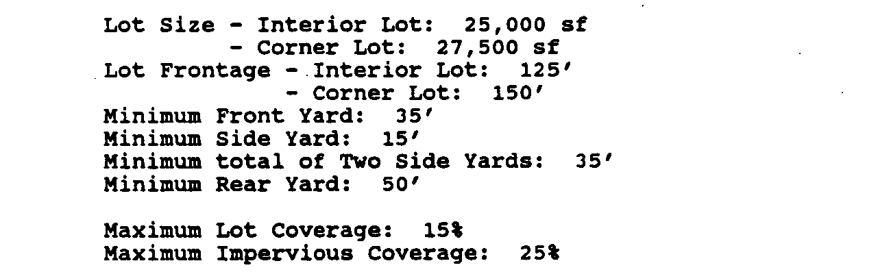
(1) The required frontage shall be met on each frontage of a corner or through lot.
(3) Yards abutting the boundaries of the entire development shall not be less than the minimum requirements for the RR3/RR5, R-40 or C-R Zone in which the tract is located under conventional zoning, provided that this requirement shall not apply if there is proposed common open space of a minimum 100 foot depth at the edge of the cluster development. C-1992
E. CLUSTER OPEN SPACE
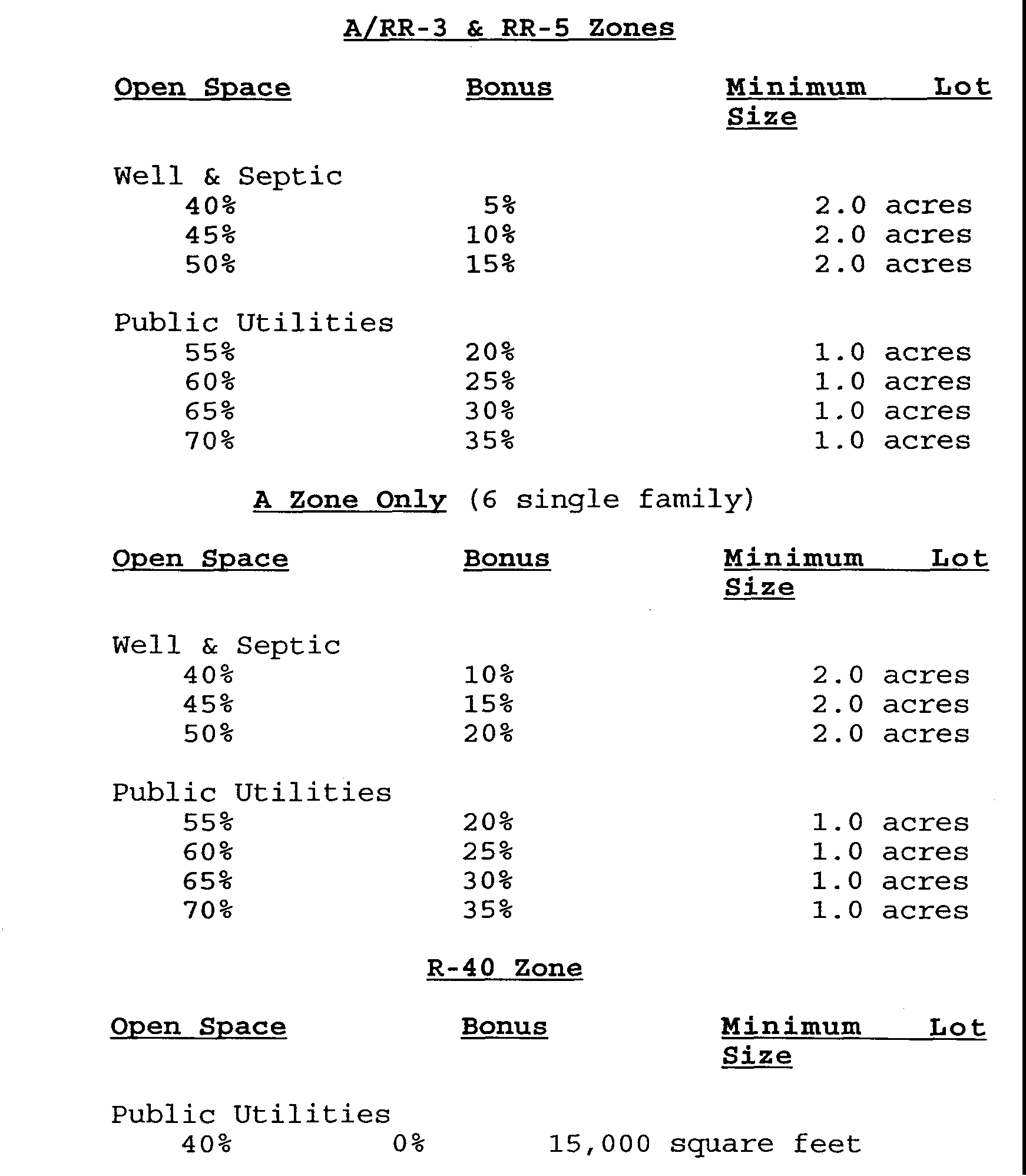
(1) Not less than 50% of the entire parcel shall be designated as cluster open space. A minimum of 33% of the cluster open space shall be in active agricultural or horticultural use at the time of filing the application for development.
(2) A plan shall be presented to the Planning Board pursuant to subsection (4) herein designed to insure continued active devotion to an agricultural or horticultural use for a period of not less than 20 years.
(3) No credit for cluster open space shall be given for land within the 100 year floodplain. Except, however, where the tract exceeds 500 acres in area, land in the 100 year floodplain shall receive credit for cluster open space provided that in no event shall such floodplain lands comprise more than twenty percent (20%) of the cluster open space.
(4) Cluster open space shall first be made available to the Township. Prior to dedication to the Township, the lands shall be improved by the Developer in accordance with Township requirements.
(5) If cluster open space is not accepted to public use, it shall be protected by legal arrangements, satisfactory to the Planning Board, sufficient to assure its maintenance and preservation in perpetuity for its intended purpose. Covenants or other legal arrangements shall specify ownership of the cluster open space; method of maintenance; responsibility for maintenance; maintenance taxes and insurance; compulsory membership and compulsory assessment provisions; guarantees that any association formed to own and maintain cluster open space will not be dissolved without the consent of the Planning Board; and any other specifications deemed necessary by the Planning Board.
(6) Lands designated as cluster open space may be incorporated into private lots which conform to this ordinance upon approval by the Planning Board that such land will be permanently protected from development, and that the proposal conforms to the intent of the cluster open space requirement.
F. APPROVAL
An applicant proposing to develop lands in accordance with the above conditions shall first submit a sketch subdivision plan to the Planning Board in accordance with standards enumerated in Section 112-12A of this ordinance. After approval of the plat by the Planning Board, the applicant may then submit a plan in accordance with the standards and conditions of Section 112-9D and Section 112-10 et. seq.
G. FINDINGS
The Planning Board shall determine, at a minimum, the following findings with respect to the proposed cluster development:
(1) The development provides for a total environment better than that which could be achieved under conventional subdivision.
(2) The application conforms to the Comprehensive Plan of the Township.
(3) The application is designed to produce an environment of stable and desirable character, consistent with the intent and purpose of the cluster development regulations to promote public health, safety and general welfare, and not out of harmony with its surrounding neighborhood.
(4) The property would be used for purposes and in a manner permitted in the existing district except for lot size and siting of dwellings.
(5) The location, size, nature and topography of the cluster open space areas make them suitable for agricultural and horticultural uses or use as common areas for park, recreational purposes and buffer areas between groups of dwellings.
(6) Cluster Open space shall include irreplaceable natural features located in the tract, such as but not limited to stream beds, significant stands of trees, individual trees of significant size and rock outcroppings; and shall also attempt to preserve existing structures of features having historic or social value to the township.
(7) If open space is intended to be improved and utilized for active recreational or active public use, it shall be easily accessible to pedestrians and designed to meet the needs of the handicapped and elderly.
(8) If open space is intended for scenic value and purposes, the suitability shall be determined by its visibility from a significant number of units or length of streets.
(9) Diversity and originality in lot layout and individual building design shall be encouraged to achieve the best possible relationship between development and the land.
(10) Property in the vicinity of the area included in the plan shall not be adversely affected by the cluster subdivision proposal.
(11) If the cluster open space is intended to be devoted to an agricultural or horticultural use, it shall be designed to be compatible with the overall development including that of the immediate area, and sufficient arrangements made in accordance with Section G5 herein to insure the maintenance and continuance of the use.

