
(Added S/26/87 by Ordinance #l339) (Repealed and Replaced 6/11/91 by Ordinance #1643)
A. OBJECTIVE
Preservation areas for perennial and intermittent streams are proposed to protect property from flooding, to reduce land development impacts on stream water quality and flows, and to provide recreation and wildlife migration corridors. This ordinance regulates development by protecting stream corridors from the type and intensity of development which would be destructive to their special environmental importance, harmful to the health and welfare of the general public, , and harmful to properties downstream. All new lots in major and minor subdivisions and all building locations in site plans shall be designed to provide sufficient areas outside of Stream Corridor Preservation Areas and within required setbacks to accommodate a structure for which it is being created as well as any normal accessory uses appurtenant thereto which would require disturbance. The requirements of this ordinance section shall not be applicable to that, portion of streams where the presence of wetlands has been verified by the New Jersey Department of Environmental Protection and where the state wetlands legislation has been ruled applicable. Where wetlands have been verified, the buffers determined by the New Jersey Department of Environmental Protection shall take precedence. On portions of streams where there are no verified wetlands, the stream corridor established by this ordinance shall be delineated.
B. STREAM CORRIDORS DEFINED
Stream corridors include four components: stream channels, flood plains, contiguous slopes of 12 percent or greater, and associated preservation areas. These components are defined as follows:
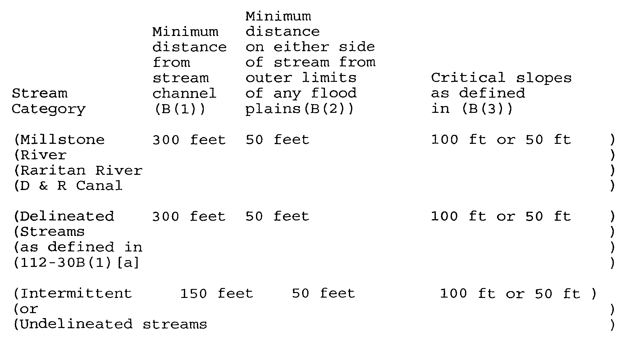
(1) STREAM CHANNELS: Stream channels for both permanent and intermittent watercourses of either delineated or nondelineated streams consist of the bed and banks of a stream within which is conveyed the normal flow of the stream, as identified on any one or more of the following:
[a] Flood Boundary and Floodway Map and Flood Insurance Rate Map. prepared by the Federal Emergency Management Agency for the National Flood Insurance Program, at a scale of one inch equals 1,000 feet, dated May 15, 1980.
[b] Soil maps from the Soil Survey of Somerset County, New Jersey, at a scale of one inch equals 1,230 feet, prepared by the U.S. Department of Agriculture Soil Conservation Service in cooperation with the New Jersey Agricultural Experiment Station, January 1972.
[c] An alignment survey, including profile and cross-sections, prepared by a licensed New Jersey Engineer and/or Land Surveyor.
[d] Such other maps as the Township may adopt. For purposes of delineation, the center line of the stream shall constitute the stream channel for all watercourses other than the Raritan River, Millstone River, and Delaware and Raritan Canal. For the three specified watercourses, the outer edge of the actual stream bed and banks shall be the stream channel from which setbacks shall be measured.
(2) FLOOD PLAINS: Flood plains are delineated in (1)(a] above, and include the flood way and the New Jersey Flood Hazard Area, and the encroachment lines of nondelineated streams. If both a 100 Year Flood Limit Line and a Stream Encroachment Line have been established, the flood plain shall be delineated by the area encompassed within both lines.
(3) CRITICAL SLOPES: Land whose slope exhibits a change in elevation greater than 12% for a horizontal distance of 10 feet or greater, and where the toe of the slope lies within 50 feet of the stream channel bank or flood plain shall be deemed critical slopes. The protection area for critical slopes shall be the lesser of:
[a] A slope distance of 100 feet from the toe of slopes having a consistently average slope of 12% or greater.
[b] A slope distance of 50 feet beyond the first point at which the slope is less than 12%.
(4) PRESERVATION AREAS: The Stream Corridor Preservation Area is required to be delineated as the most restrictive limit of any of the three distances established in accordance with the following schedule: [Amended 3/14/00 by Ord. No. 3112]
C. RELATIONSHIP TO FLOOD HAZARD MITIGATION REQUIREMENTS
Except in limited cases, the stream corridor requirements of this ordinance do not permit structures within the stream corridor which, by definition, includes the flood hazard areas. The flood mitigation requirements of Ordinance #994 apply only in those limited cases where structures or substantial improvements to structures are permitted.
D. PROHIBITED USES AND ACTIVITIES
Prohibited uses and activities shall include but not necessarily be limited to the following:
(1) New construction or replacement of free standing structures, buildings, and retaining walls not in the public interest.
EXCEPTIONS
Additions and/or landscaping, bridges and driveways to principal single family structures existing as of the date of this ordinance (5/26/87) on lots or portions of lots located within the stream corridor meeting the below listed criteria:
CRITERIA 1 - Addition and or landscaping shall not affect natural drainage as determined by the Township Engineer.
CRITERIA 2 - Addition and or landscaping will not encroach into the flood hazard area.
CRITERIA 3 - Addition shall not exceed 33% of the gross floor area.
(2) New construction of on-site sewerage disposal systems.
(3) Any solid or liquid waste or refuse disposal including sanitary landfills, dumps, transfer stations, and wastewater lagoons.
(4) Junk yards, commercial and industrial storage facilities and the open storage of vehicles and materials.
**Webmasters Note: The previous subsections, B(3) through D(4), have been amended as per the 2000 Supplement.
(5) Barns, stables, feedlots, barnyards, dry lots, poultry buildings, and farm waste disposal facilities.
(6) Facilities for the storage of hazardous or toxic materials.
(7) Altering of watercourses (realigning, straightening, widening, or grading of the streambed).
(8) Regrading of natural contours.
(9) Filling.
(10) Removal of fill.
(11) Detention or retention basins and other stormwater management facilities, excluding outflow structures if designed to minimize impact on the stream corridor.
(12) Cutting and clearing of trees.
(13) Temporary or permanent construction easements.
E. CONDITIONAL USES AND ACTIVITIES
The following uses and activities may be permitted upon a finding of fact that the proposal is not significantly contrary to the objectives of this ordinance:
(1) Recreational use, whether open to the public or restricted to private membership, not to include enclosed structures, but permitting piers, docks, floats, or unenclosed shelters usually found in developed outdoor recreational areas.
(2) Installation or replacement of sewerage treatment plants, sewage pumping stations, or sanitary or other utility lines within or across the stream corridor in periods of low flow.
(3) Private or public water supply wells provided With a sanitary seal, flood proofed water treatment facilities or pumping facilities, when approved by the Township Engineer, the Township Health officer, and the New Jersey Department of Environmental Protection.
(4) Culverts, bridges, road or driveway crossings, other than, those exempted in 112-30D(a) above.
(5) Fences of wood, 'wire or other material which will not impede the flow of floodwaters and passage of debris. No fence shall be erected which will prevent the passage of recreational craft.
(6) Maintenance or renovation of existing on-site waste disposal facilities that cannot be relocated outside the stream corridor.
(7) Restoration of watercourses in cases where restoration to their former natural channels after diversion by floods is demonstrated to be necessary to protect individual property or is in the public interest.
(8) Rebuilding of pre-existing structures outside of the floodway, provided the requirements of Ordinance 994 regulating flood hazard areas are met.
(9) Ponds and lakes if flow of feeder stream(s) can be demonstrated to be sufficient to sustain volume.
(10) Cutting and clearing of trees where necessary in connection with the above conditional uses and activities or where replacements are approved by the Township Engineer.
(11) Pasture and controlled grazing of animals.
(12) Wildlife sanctuary and/or woodland preserve, exclusive of structures.
(13) Hunting and fishing reserves operated for the protection and propagation of wildlife, exclusive of structures.
F. APPLICATIONS FOR STREAK CORRIDOR DEVELOPMENT
Any development or use requiring approval under Section 112-30E of this ordinance shall require either site plan review or subdivision review pursuant to Sections 112-10 et. seq, and 112-15 et. seq. of the Township of Franklin Development ordinance. The procedures and standards of review prescribed in 112-10 et. seq. and 112-15 et. seq. shall be applicable and shall be in addition to the requirements for submission listed in Section 112-30G. Nothing in this section shall relieve an applicant from complying with other requirements that are applicable to the development.
G. STREAM CORRIDOR PLAN REQUIREMENTS
The following information shall be supplied for any development within a stream corridor. Such information shall be in addition to information required by Section 112-10 et. seq. and 112-15 et. seq., Subdivision and Site Plan:
(1) Delineation of the flood hazard area and floodway as identified in Section 112-30B(l) and (2). When base flood elevation data have not been provided in accordance with this requirement, the Township Engineer shall obtain, review, and reasonably utilize any base flood elevation data available in order to administer the standards of this ordinance.
(2) Delineation of stream corridors as defined in 112-30B.
(3) Detailed Hydrologic engineering studies of a detail satisfactory to the Township Engineer which indicate the effects on drainage and streams on all adjacent properties as well as the property in question, including the necessary data to determine whether the boundaries of the stream corridor would be affected if the application were granted.
(4) A plan indicating the disposition of any fill materials proposed to be deposited by the grading or regrading of land.
(5) The designation of how suitable techniques, including erosion and soil stabilization measures, sediment traps and nutrient control by vegetation filters or other mechanisms will be incorporated to protect the stream.
(6) A demonstration that the use or activity cannot be located outside the stream corridor.
H. STREAM CORRIDOR CONSERVATION EASEMENTS
An approved application for development or use on a lot which contains a stream corridor or portion of a stream corridor shall provide a conservation easement delineated by metes and bounds for the continued protection of the stream corridor. Conservation easements shall be established by deed if no subdivision map is being filed, or by plat filed with the County Recording officer in compliance with the Map Filing Law.
1. MONUMENTS
Appropriate monuments shall be set by the licensed land surveyor. Such markers shall be set at each conservation easement corner not previously marked by a monument. All boundary markers shall be described on the survey provided to show their relation to the property or corner or, if appropriate, to the boundary lines.

