
**Webmasters Note: The previous schedule has been amended as per Ordinance No. 3386.
J. QUARRYING REQUIREMENTS
(1) BASIS FOR THIS SECTION
The Township of Franklin has deposits of natural materials that have the potential for productive economic exploitation. It is the declared policy of the Township to encourage the proper utilization of such natural resources through the establishment of this zone,. which limits such activity to ensure that it does not adversely affect adjoining lands.
(2) NEED FOR A SITE PLAN
Prior to the issuance of a building permit or a certificate of occupancy for any use in the M-3 Mining and Manufacturing zone, a site plan shall be submitted to the Township Planning Board in accordance with the governing site development plan procedure, and other applicable requirements of Township ordinances.
(3) GENERAL REQUIREMENTS FOR SITE PLANS
Where mining operations and their accessory uses are involved, the site plan submitted shall include the site layout, plan of construction, topographic details and such other information and material as may be required to indicate the full scope of the operation. The site plan and any supporting plans shall be drawn accurately and to scale.
(4) SITE PLAN SPECIFICATIONS
The site plan and supporting documentation must include the following:
(a) The name and address of the applicant, if an individual: the name, residence and business address of each partner, if a partnership; or if a corporation, the name, date and state in which it was incorporated, whether authorized to do business in New Jersey and the names of directors, principal officers and local representatives, their residence and business address.
(b) Information showing ownership of the tract involved and the written consent of the owner thereof, if the applicant is not the owner.
(c) Topographic detail adequate to show existing and proposed grading of the land.
(d) Plans showing the places on the tract where quarrying and. , accessory uses. shall be conducted. All entrances or exits and fences or gates erected or to be erected must be shown.
(e) Plans for the rehabilitation of the property in question, showing how it may be restored to a productive use after mining operations have been completed, in keeping with the Master Plan adopted for the Township.
(f) The hours during which the various operations of the quarry will be operated.
(5) SPECIFICATIONS FOR THE SITE REHABILITATION PLAN
Such plans shall indicate measures to be taken during the course of the operation which will lead to rehabilitation of the site as well as showing a plan for the ultimate rehabilitation. These plans shall include the following provisions:
(a) Provision shall be made for the restoring of all slopes to a grade not to exceed 30 degrees, except however where slopes exist as of the date of this ordinance which are of such degree that it is impractical to rehabilitate the same to a grade not in excess of 30 degrees. The rehabilitation plan may provide for such slopes to remain as they are, provided that adequate safety and erosion controls are incorporated into said plan.
(b) Where topsoil is removed, provisions shall be made for the setting aside and retention on the premises of sufficient arable soil to be redistributed over the premises to a depth capable of supporting vegetation. Where the final contour is of such slope to make impractical the replacement of topsoil, such slopes shall be planted with rootable plant material in sufficient number and of sufficient size to minimize erosion.
(c) Provisions shall be made for reasonable portions of initial or existing quarrying operations to. be. rehabilitated prior to the opening of new areas. To the extent practicable, the rehabilitation plan shall make provision for simultaneous quarrying and rehabilitation.
(d) The foregoing provisions shall also apply to the rehabilitation and restoration of other areas where the quarrying of rock is in process or has been terminated or where stone or other material is being or has been removed such as, but not limited to, the case in any road realignment program.
(e) Provisions shall be made for performance guarantees by the applicant sufficient to insure. the completion of the rehabilitation plan or parts or stages thereof in such form as may be approved by the Township Attorney and in such amount as may be approved by the Township Council.
(f) When approving plans for rehabilitation and reclamation submitted in accordance herewith, the Planning Board shall specify a time limit within which such reclamation shall be commenced and terminated as to the entire rehabilitation/ reclamation plan or any stage or part thereof. Periodic inspections shall be made by representatives of the Township Engineer and/or Health office or other proper Township officials to evaluate the performance of the applicant with respect to rehabilitation/reclamation procedures.
(g) In order to evaluate the foregoing, the Planning Board and/or the Township Council may solicit information from the Township Health Officer, Township Environmental Commission and other relevant municipal employees and/or consultants.
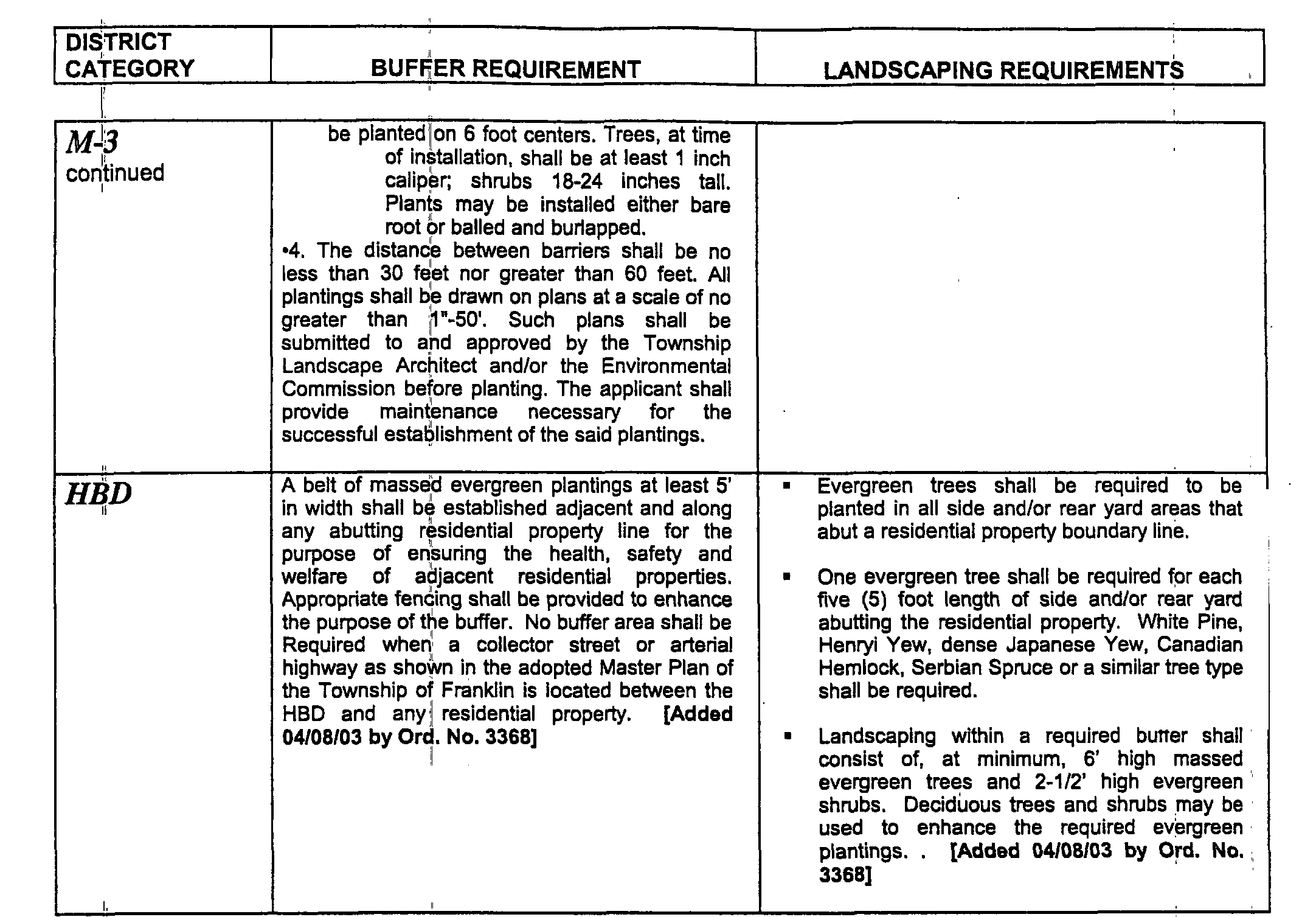
(6) HOURS OF OPERATION
(a) Mining and related activities are prohibited on Sunday.
(b) Mining operations including but not limited to stripping and drilling are restricted to the hours of 5:00 a.m. to 8:00 p.m.
(c) Igniting of explosives, commonly known as blasting, is restricted to the hours of 8:00 a.m. to 5:00 p.m.
(d) Primary crushing operations, including in-plant hauling and loading are restricted to the hours of 5:30 a.m. to 10:30 p.m. Secondary crushing operations, including in-plant hauling and loading, are restricted to the hours of 5:00 a.m. to 11:00 p.m.
(e) Operations of accessory uses, including but not limited to bituminous concrete and portland cement concrete production, are restricted to the hours of 5:00 a.m. to 8:00 p.m. except when a written contract or sub-contract with federal, state, county or municipal government or public authority specifically requires delivery at other times.
(f) The transporting of materials produced or processed on premises in the M-3 Zone by vehicles entering and leaving said premises is restricted to the hours of 5:00 a.m. to 8:00 p.m. except when a written contract of sub-contract with federal, state, county or municipal government or public authority specifically requires delivery at other times.
(7) CONTROLLING ROAD DUST
The roads or rights-of way within the quarry premises which do hot have permanent pavement shall be treated as is determined to be necessary by the Township Engineer. Those roads or rights-of-way which are permanently paved shall be wetted down periodically to sufficiently control dust or spillage.
(8) WASTE DISPOSAL
Stone or other products of quarrying shall not be deposited as waste, spillage or storage in any manner on adjacent properties or on roads of the Township. Provisions shall be made for the disposal of any waste products resulting from any of the mining operations on the premises thereof, and a landfill cover method shall be employed periodically to accomplish that objective.
(9) FENCES FOR SAFETY
(10) USE OF EXPLOSIVES
All explosives must be handled strictly in accordance with state regulations.
(11) MATERIAL STOCKPILES
Where conveyors discharge material, the average size which is less than three-eighths (3/8) of an inch in diameter, onto stockpiles of such materials, the following shall be adhered to:
(a) The free fall of the material being stockpiled from the conveyor to the highest point of the stockpile shall not exceed a distance of six (6) feet.
(b) A high pressure mist water spray shall be directed on said material as it falls from the conveyor to the stockpile so as to reduce possibilities of dust.
(c) Where screenings are stockpiled, same shall be enclosed within a building or structure.
(12) SAFETY PROCEDURES
Processing areas shall be maintained in the safest practicable conditions at all times. In no case shall permitted processing menace the physical safety of persons or property on public streets or adjoining property.
(13) AIR POLLUTION CONTROL
Dust and smoke from processing operations shall be minimized by the installation and use of appropriate mechanical and electrical devices. Anything to the contrary not withstanding, all mining operations, principal and accessory, shall comply with the requirements of the New Jersey State Department of Health.
K. CANAL PRESERVATION DISTRICT (Added 4/25/89 by Ordinance #1481)
(1) AREA AND YARD REQUIREMENTS
The following area and yard requirements shall apply to single family dwellings in the Canal Preservation District:
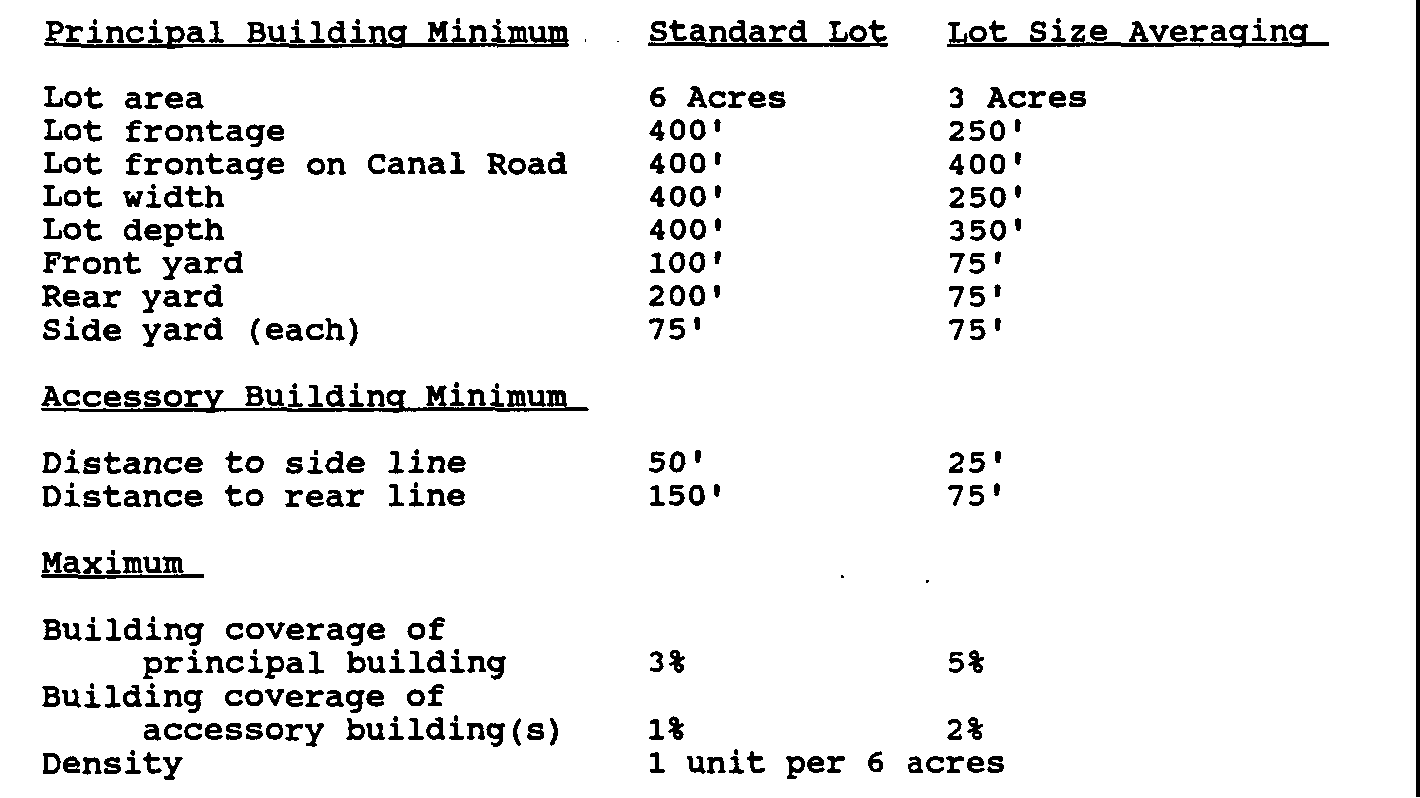
(2) LOT SIZE AVERAGING
The minimum lot size may be reduced to three (3) acres provided that the average lot size throughout the development shall be at least six (6) acres. Any lots larger than six (6) acres shall be permanently deed restricted from further subdivision and development in the future other than use for either agriculture or a combination of agriculture and one dwelling unit. In addition, any land area in excess of the minimum lot size may be donated or transferred to the Township or its designee for the purposes outlined in Section 112-6D and provided further that the Township shall have the right of first refusal for any such land that is offered. The proposed lots shall meet all requirements for safe septic system operation established by applicable Township, County, and State regulations.
(3) GENERAL REQUIREMENTS
The following general requirements shall apply to all structures, in the Canal Preservation District.
(a) Setbacks. The following minimum setbacks shall be maintained for all structures:
[1] 250' from the D & R Canal Park
[2] Exceptions to the above setbacks may only be granted upon a demonstration that existing, adjacent development is within the required setback areas and the proposed development is architecturally consistent with the 19th Century architecture that is prevalent in the area, as approved by the Historic Preservation Commission. No development may be any closer to the Canal and Canal Road than the average setback of development on the adjoining lots.
(b) Street alignment. The following standards shall apply to the construction of new streets in the Canal Preservation District:
[1] Linear streets are incompatible with the topography and landscape of the District and are discouraged, except in situations where they are appropriate or necessary so that adjoining lots can share a street.
[2] Curvilinear streets are more suitable to minimize the topographic modification
associated with their construction and to visually shield the street cut from view from the Canal. Curvilinear streets shall be incorporated into the design of the subdivision where possible.
[3] Where it is impossible to shield the new street from view through the use of existing topography, the applicant shall provide sufficient landscaping and/or berming to completely screen the new street from the Canal.
(c) Access, The following standards shall apply to subdivisions in the Canal Preservation District.
[1] Street design and location shall include provisions for street access to adjoining properties where required by the Planning Board.
[2] Where a tract is subdivided into larger parcels than ordinary building lots, such parcels, unless deed restricted against further subdivision, shall be arranged to allow the opening of future streets and logical subdivisions.
[3] No cul-de-sac shall provide access to more than ten lots. Any cul-de-sac in excess of 1,000 feet shall provide a midpoint turnaround as determined by the Planning Board, and shall incorporate provisions for street access to adjoining properties.
[4] Where a tract has access to a street other than Canal Road, the proposed subdivision shall utilize such alternative access for its primary access.
[5] Adjacent lots shall share access wherever feasible, and shall incorporate provisions for street access to adjoining properties.
(d) Vegetation removal. No more than 15% of the wooded area of a proposed lot shall be cleared for development.
(e) Landscaping. The following landscaping standards shall apply to all new development in the Canal Preservation District.
[1] General. Landscape plans shall conform to the following general principles.
[a] Use landscaping to accent and compliment dwellings and garages. For example, groupings of tall trees to break up long, low buildings and lower plantings for taller buildings.
[b] Locate landscaping to provide for climate control. For example, shade trees on the south to shield the hot summer sun and evergreens on the north side for windbreaks.
[c] Provide for a variety and mixture of. landscaping. The variety shall consider susceptibility to disease, colors, season, textures, shapes, blossoms, and foliage.
[d] Local soil conditions and water availability shall be considered in the choice of landscaping.
[e] Consider the impact of any proposed landscaping plan at various time intervals so that, for example, shrubs do not grow and eventually block sight distances or encroach upon roads or sidewalks.
[f] All landscape plants shall be typical full specimens conforming to the American Association of Nurserymen Standards and/or Landscape Plans and Specifications for quality and installation.
[g] Assure that no aspect of the landscape design inhibits access to the development by emergency vehicles.
[2] Street trees. Street trees shall be provided for all streets and shall be in accordance with the following standards for location, species selection and spacing.
[a] Vary street varieties, with spacing 2' to 3' from the right of way and sizes 2 to 3 caliper.
[b] The total number of street trees shall average 1 for every 35 linear feet measured at the street or curb line.
[c] Planting design shall accentuate views and integrate contrasting landscape elements.
[d] No street trees shall be located within a sight triangle.
[3] Cul-de-sacs. Landscaped islands shall be provided on each cul-de-sac. Cul-de-sac islands provide an opportunity to create visual interest, soften the harshness of a large paved area, increase groundwater recharge, screen headlight glare into residences, and preserve existing vegetation.
[a] The following general standards shall apply to the landscape treatment of cul-de-sacs.
<1> All plants shall be tolerant of harsh, dry roadside conditions.
<2> Ground cover plantings shall be consistent with the degree of maintenance expected for the cul-de-sacs and of sufficient density to entirely cover the ground plane.
[b] one of the following cul-de-sac planting concepts, or an alternative concept complying with the standards set forth above, shall be used.
<1> The preferred alternative is to use cul-de-sac islands to preserve existing stands or groves of trees. Assure protection during construction. Indicate ground cover treatment. If the existing trees do not merit preservation, then concept (2) or (3) may be utilized.
<2> Use a specimen tree of 5 to 6 caliper with low shrub or ground cover planting.
<3> Use three or more trees of varying size (2-1/2 - 6 caliper) with low shrub, or groundcover and gentle berming.
[4] Stormwater. Stormwater management areas include drainage ditches and swales, retention and detention basins, and wetland areas. sensitively-designed swales and basins can benefit the health, welfare, and safety of Franklin Township residents. This may involve integration of these areas as aesthetic landscape features, naturalized wetland areas, or active and passive recreation areas, in addition to their stormwater management function. Stormwater management by use of roadside swales and ditches shall be the preferred alternative where established by drainage calculations. Such channels shall follow the general design detail of 2' of stone surrounded by permeable filter fabric, overlain with 6 of sand and soil.
The following landscape concept for stormwater detention areas, or an alternative and equivalent concept complying with these standards, shall be used if swales are found to be ineffective, and the stormwater detention area cannot be put to agricultural or horticultural use:
[a] The area shall be graded creatively to blend into the surrounding landscape and imitate a natural, depression with an irregular edge. This shall include gentle berming. Linear, geometric basins are unacceptable.
[b] The quantity of trees to be planted on the interior of the basins shall be equal to the number of trees that would be necessary to cover the entire area, based upon a 20' by 20' grid to the high water line or outflow elevation. of this number, 10% shall be 2-1/2-3 caliper, 20% shall be 1-2 caliper, and 70% shall be 6'-8' ht. whips.
[c] The trees shall be planted in groves and spaced 5' - 15' on center.
[d] The ground plane shall be seeded with a naturalization, wildflower, and/or meadow grass mix. The specific blend shall be approved by the Township Landscape Architect.
[e] All woody and herbaceous plants shall be species indigenous to the area and/or tolerant of typical wet/dry floodplain conditions.
[f] Plantings shall not be located within 20' of low flow channels to allow for maintenance.
[g] The perimeter area (slopes above the high water line) shall include shade trees (approximately 80/1000 linear feet), evergreen trees (approximately 40/1000 linear feet) , ornamental, trees, and shrubs screening drainage structures and creating visual interest.
[h] Provision for emergency access as well as general maintenance of the basins shall be reviewed by the Township Engineer. Plantings shall be designed to disguise yet not hinder vehicular access.
[i] Plantings are not permitted upon any dikes associated with a detention basin unless approved by the Township Engineer.
(f) Screening. Screening shall be required around the perimeter of structures visible from the D & R Canal Park.
[1] The following standards shall apply:
[a] Provide landscape buffer area of 25' in width. The buffer area shall be planted in a double row of 4' to 5' evergreens planted 10' on center, or an equivalent.
[b] Preserve existing trees within the landscape buffer area. If existing vegetation is insufficient, the landscape strip shall be supplemented with new understory plantings of shade-tolerant coniferous and ornamental trees in naturalistic groupings.
[c] In areas of necessary disturbance, existing quality vegetation shall be relocated for use in other areas. Detailed plans for tree removal and relocation must be made on plans and in the field (tag trees) for review and inspection.
[2] In areas devoid of existing vegetation, the following standards shall apply:
[a] Provide gentle berming with masses and groupings of evergreen shade, and ornamental trees and shrubs. The planting may be predominantly mixed varieties of shade trees and evergreen shrubs. Parked cars shall be screened from view from the D & R Canal Park and Canal Road. Shrubs used to screen headlight glare shall be spaced a minimum of 2' on center as a double row.
[b] The landscape design shall provide shade for parking areas and evergreen and ornamental trees to screen nuisances and emphasize appropriate views.
[c] All plants shall be tolerant of harsh roadside conditions.
[d] If a 25' landscape strip cannot be provide, a row of evergreen trees or a combination of a low wall and berm with planting may be required.
[e] Minimum plant sizes shall be shade trees 2 - 2-1/2 caliper, evergreen and ornamental trees 4' - 5' ht., and shrubs 2' ht.
(g) Steep slopes. The following standards shall apply to areas with slopes in excess of 12% and 25%, respectively.
[1] In areas with slopes of 12% to 25%, no more than 15% of such areas shall be developed and/or regraded or stripped of vegetation and, for purposes of subdivision or the issuance of a building permit for a new dwelling, each lot must include a minimum of one contiguous acre of land with less than 15% slope on which all development shall occur.
[2] In areas with slopes of 25% or more, no development, regrading or stripping of vegetation will be permitted.
(h) Viewsheds. The following standards shall apply to new structures in order to protect the view into the proposed lot from the D & R Canal Park and Canal Road.
[1] New structures should be sited behind visual barriers, such as trees, rock outcroppings, vertical cliff faces and ridge lines.
[2] on sloping hills new structures should be located at any point in the foreground to midground of the hill to not create a barrier which will be visible from the D & R Canal Park or Canal Road, or will block the view of distant hills.
L. LOT SIZE AVERAGING IN THE RR-3 DISTRICT (Added 11/14/89 by ordinance # 1525)
(1) Purpose. In some situations the overall planning for a tract may better respond to the intent and purpose of this ordinance if flexibility in the design of a subdivision is permitted. The applicant must clearly demonstrate to the Board that the lot size averaging plan is preferable to the conventional, plan in the achievement of the goals, objectives and purposes of this ordinance and the Township's Master Plan. Factors to be considered in this demonstration include, but are not limited to, stream corridor and wetlands preservation, soil suitability, steep slope protection, woodland protection, habitat protection, overall site design, reduced impervious coverage, and improved circulation. The Planning Board shall have the authority to determine whether the lot size averaging plan is preferable.
(2) The minimum tract area shall be 20 acres.
(3) The lot size averaging development plan shall not result in a greater dwelling unit density than if the property in question were developed as a conventional subdivision. For purposes of determining the maximum number of lots permitted under lot size averaging, either of the following methods may be employed:
[a] The applicant shall submit a concept plan of conventional subdivision layout. The concept plan shall be in sufficient detail to permit the Planning Board to make an informed decision as to the subdivision satisfying all ordinance requirements and in a form that would be acceptable to the Planning Board as a conventional subdivision without the need for any lot area or lot dimension variances or exceptions to subdivision design standards. The number of lots shown on an accepted concept plan shall be the maximum number of lots permitted under lot size averaging; or,
[b] The maximum number of lots shall be equal to eighty (80) of the area of the tract divided by the minimum conventional lot size of 3 acres.
(4) The minimum lot size may be reduced to two (2) acres provided that the average lot size throughout the development shall be at least three (3) acres. Any lots larger than three (3). acres shall be permanently deed restricted from further subdivision and development in the future other than use for one dwelling unit. In addition, any land area in excess of the minimum lot size may be offered to the Township or its designee for the purposes outlined in Section 112-6D (2) (a), at the option of the Township Planning Board and Council. The Township shall have the right of first refusal for any such land that is offered. The proposed lots shall meet all requirements for safe septic system operation established by applicable Township, County and State regulations.
M. LOT SIZE AVERAGING IN THE RR-5 DISTRICT (Added 11/14/89 by Ordinance # 1525)
(1) Purpose. In some situations the overall planning f or a tract may better respond to the intent and purpose of this ordinance if flexibility in the design of a subdivision is permitted. The applicant must clearly demonstrate to the Board that the lot size averaging plan is preferable to the conventional plan in the achievement of the goals, objectives and purposes of this ordinance and the Township's Master Plan. Factors to be considered in this demonstration include, but are not limited to, stream corridor and wetlands preservation, soil suitability, agricultural retention, steep slope protection, woodland protection, habitat protection, overall site design, reduction of impervious coverage, and improved circulation. The Planning Board shall have the authority to determine whether the lot size averaging plan is preferable.
(2) The minimum tract area shall be 30 acres.
(3) The, lot size averaging development plan shall not. result in a greater dwelling unit density than if the property in question were developed as a conventional subdivision. For purposes of determining the maximum number of lots permitted under lot size averaging, either of the following methods may be employed:
[a] The applicant shall submit a concept plan of conventional subdivision layout. The concept plan shall be in sufficient detail to permit the Planning Board to make an informed decision as to the subdivision satisfying all ordinance' requirements and in a form that would be acceptable to the Planning Board as a conventional subdivision without the need for any lot area or lot dimension variances or exceptions to subdivision design standards. The number of lots shown on an accepted concept plan shall be the maximum number of lots permitted under lot size averaging; or,
[b] The maximum number of lots shall be equal to eighty (80%) percent of the area of the tract divided by the minimum conventional lot size of 5 acres.
(4) The minimum lot size may be reduced to three (3) acres provided that the average lot size throughout the development shall be at least five (5) acres. Any lots larger than five (5) . acres shall be permanently deed restricted from further subdivision and development in the future other than use for one dwelling unit. In addition, any land area in excess of the minimum lot size may be offered to the Township or its designee for the purposes outlined in Section 112-
6D(2)(b), at the option of the Township Planning Board and Council. The Township shall have the right of first refusal for any such land that is offered. The proposed lots shall meet all requirements for safe septic system operation established by applicable Township, County and State regulations.
N. OPEN SPACE MARKERS Added 7/8/97 by Ord. No. 2021]
In addition to any relevant requirements of the New Jersey Map Filing Act, N.J.S.A. 46:23, et seq, and as required for Stream Corridors elsewhere in this Chapter, open space including Cluster, Common, Useable and Public Open Space and Preservation Areas shall have:
(1) Approved Survey Markers located at all boundary corners of preservation areas and intersecting property lines and such other locations as shall be determined by the Planning Board or Board of Adjustment; and
(2) Open Space Markers located at all boundary corners of preservation areas and other such locations as shall be determined by the Planning Board or Board of Adjustment, in accordance with the following specifications:
(a) Open space markers shall be Aluminum markers, 3 x 3 1/2, and shall conform in design and color with a sample marker available for sale at a cost of $10.00 in the office of the Township Clerk. open space markers shall be secured to the upper faces of the posts facing the open space boundary.
(b) Open space markers shall be placed on 4 x 4 x 5'0 long pressure-treated lumber posts. Posts shall be embedded into concrete to a depth of two (2') feet leaving three (3') feet exposed above the final grade or existing grade of the surrounding land. Posts shall be located one (1') foot inside of the preservation area boundary line adjacent to all monuments and other approved survey markers set in compliance with N.J.S.A. 46:23 and as required by the Planning Board or Board of Adjustment.
(c) Preservation Area boundary lines shall be established by a Licensed Land Surveyor and shall be shown on the Final subdivision or Final Site Plan Map.
(d) All costs for the establishment of location, marking, purchase and installation of approved survey markers and open space markers shall be borne by the developer.
(e) If boundary lines are in excess of three hundred (300') feet, open space markers shall be equally spaced at a maximum intervals of three hundred (300') feet.
0. Senior Citizen Village District [Relocated from 1129B(24) and amended 8/8/00 by Ordinance #3148; 10/24/00 by Ordinance #3163]
There is hereby permitted and authorized the establishment of:
Planned Senior Citizen District for Block 513 and same shall be an amendment to the official Zoning Map of the Township of Franklin, County of Somerset, State of New Jersey.
Planned Senior Citizen District Overlay for Block 50? in its entirety and Block 468.12/Lot 1.01 and same shall be an amendment to the Official Zoning Map of the Township of Franklin, County of Somerset, State of New Jersey.
The provisions of this section shall only apply to the Senior Citizen Village District and Senior Citizen District Overlay as herein defined and in accordance with the provisions and requirements of this section.
1. Definitions
ADULT COMMUNITY - a planned community designed to meet the needs of and exclusively for, the residents of an age restricted segment of the population where the head of the household is, at a minimum age of fifty-five (55) years of age, except that due to death, a remaining spouse of less than fifty-five (55) years of age shall be permitted to continue to reside and further provided that no person under nineteen (19) years of age shall reside in any dwelling unit for more than 90 days in any calendar year.
ASSISTED LIVING RESIDENTIAL HEALTH CARE FACILITY -a facility which is licensed by the Department of Health to provide apartment-style housing and congregate dining and to assure that assisted living services are available when needed for four or more adult persons unrelated to the proprietor. Apartment units offer, at a minimum, one unfurnished room, a private bathroom, a kitchenette and a lockable door on the units entrance.
ASSISTED LIVING - a coordinated array of supportive personal and health services available 24 hours per day to residents who have been assessed to need these services, including residents who require formal long-term care. Assisted living promotes resident self direction and participation in decisions that emphasize independence, individuality, privacy, dignity and homelike surroundings.
COMPREHENSIVE PERSONAL CARE HOME - a facility which is licensed by the Department of Health to provide room and board and to assure that assisted living services are available when needed, to four or more adults unrelated to the proprietor. Residential units in comprehensive personal care homes house no more that two residents and have a lockable door on the unit entrance.
CONGREGATE-CARE FACILITY - housing for independent and semi-dependent living which provides support services, including but not limited to religious, recreational, housekeeping, laundry, transportation, dining and health-care facilities which are contiguous to or included within the facility.
HEALTH CARE FACILITY - a facility so defined in N.J.S.A. 26:2H-1 et seq., and amendments thereto.
2. Purpose
The purpose and intent of the District is to enable the planned development, pursuant to N.J.S.A. 40:55D-45.1 to 45.8, of a Senior Citizen Village District which shall also provide for recreational, medical and shopping facilities and similar services required by the residents thereof in accordance with a comprehensive site development plan approved by the Planning Board of the Township.
3. Required Tract Size [Amended 8/8/00 by Ordinance #3148; 10/10/00 by Ordinance #3163]
For the Planned Senior Citizen District - A minimum of 200 contiguous acres. For the purposes of this section, the existence of a public street right-of-way shall not be deemed to interrupt contiguous acreage. For the Planned Senior Citizen District Overlay - A minimum of 70 contiguous acres.
4. Permitted Uses
Independent Residential Dwelling Units
Single-family detached and semi-attached dwellings. Multi-family structures containing 3 or more dwellings including triplex, quadraplex, town house and multi family apartment buildings.
Recreational and Support Facilities including club house, swimming pool, tennis courts, etc.
Licensed & Other Residential Health Care Facilities such as but not limited to Assisted living/congregate care facilities, nursing homes and adult day care.
Shopping and service facilities including but not limited to grocery store, book and stationary, pharmacy, restaurant, , doctor and dentist office, places of worship, retail goods and service stores of a neighborhood service type including but not limited to food, drugs, drink, household supplies, hardware stores, barber and beauty shops, shoe repair and tailor shops, dry cleaning shops, professional offices, banks and restaurants.
Eating and drinking establishments.
Quasi-public or private club or fraternity.
Community or civic facilities included but not limited to community residences, eleemosynary uses, and outpatient clinic.*
5. Gross density [Amended 1/9/01 by Ord. No. 3193]
3.8 dwelling units per gross acre of tract. Gross density shall not include assisted living residential units, congregate housing, comprehensive personal care home or nursing beds.
6. Height Area and Bulk Requirements for Independent Living
Residential Dwellings
Single-family detached dwelling
Minimum lot size - 4,500 square feet
(not to exceed 33 % of the total number of single family lots, and further provided that no less than 50% of all single family lots shall be 5,500 square feet or greater.
Lot width (at set back line) - 45 feet
Front yard - 20 feet from curb face and further provided that no driveway shall be less than 20 feet in length, measured from the garage door to the sidewalk or curb as the case may be.
Side yard - 5 feet
Both side yards - 15 feet
Rear yard - 15 feet
Semi-detached [Amended 8/8/00_by Ordinance #3152]
Minimum lot size - 3,750 square feet,
All other bulk standards - same as above, except one side yard 0 feet,
Both side yards - 10 feet
Triplex/Quadraplex (3 to 4 Single family units in one structure)
Front yard - 20 feet from curb face
Side yard - 15 feet side to side of adjacent buildings or 5 feet to lot line whichever the greater.
Rear yard - 30 feet back to back of adjacent buildings or 15 feet to lot line whichever the greater.
Note: No front to back building arrangement shall be permitted.
Front yard - 20 feet from curb face
Side yard - 15 feet side to side of adjacent buildings
Rear yard - 50 feet back to back of adjacent buildings
Note: No front to back building arrangement shall be permitted.
Maximum height - 3 stories/50 feet maximum height
Maximum units per structure - 60 units
Side yard - 15 feet side to side of adjacent buildings
Rear yard - 50 feet back to back of adjacent buildings
Note: No front to back building arrangement shall be permitted.
7. Height, Area and Bulk Requirements for Commercial and Senior Citizen Support Uses Including Assisted Living Residential Health Care Facilities, Comprehensive Personal Care Home and Nursing Home.
Min. lot size - 2 acres.
Min. lot frontage - 100 feet.
Min. front yard - 75 feet.
Min. side yard - 20 feet.
Min. both side yards - 50 feet
Min. rear yard - 30 feet.
Max. height - 50 feet.
Max. percent lot coverage by buildings - 40%.
Max. percent impervious coverage by buildings and pavement (total impervious surface) - 80%.
8. Requirements and Restrictions for Commercial and Senior Citizen Support Facilities and Uses: [Amended 1/9/01 by Ord. No. 3193]
Commercial retail and service uses shall not be permitted in any structure containing a dwelling unit. The required min/max percent of gross project area to be developed for commercial purposes shall be 0% min. /3% max., and for senior citizen support facilities shall be 0 % min. 15 % max. Such uses shall be separate and apart from common area proposed except that limited retail/service uses of no more than 10,000 s.f. of floor area may be located within a structure(s) owned by the Owner's Association.
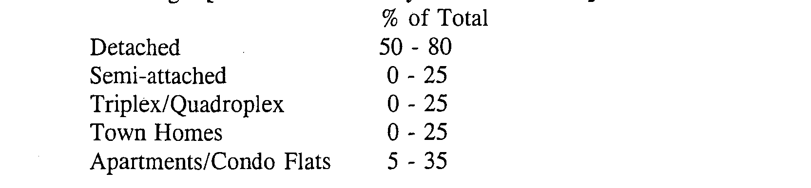
9. Required Housing Type Mix of Independent Living Residential Dwellings [Amended 1/9/01 by Ord. NO. 31931
10. Other Requirements
Club House - facility or facilities providing pool, tennis, and other activities including game rooms and general multi-purpose space. A minimum of 14 s.f. of floor area per independent living unit shall be provided.
Open Space/Recreation Facilities and Area - 20.0% of the gross acreage of the tract shall be open space and improved recreation areas of which a minimum of 7.5 % of the gross acreage shall be improved recreational facilities including but not limited to club house, tennis, pool, bikeways, village parks, play field areas and support facilities. Open space/recreation areas shall not include paved roadways, parking areas provided for attached residential dwellings or any portion of a lot in fee simple individual ownership. Pedestrian walkways shall be included in the open space/recreation area calculation.
**Webmasters Note: The previous subsections, O.3 through the previous paragraph of O.10, have been amended as per the 2001 Supplement.
Pedestrian Paths/Bikeways - Each dwelling shall have immediate access to a pedestrian path (sidewalk) or bikeway located to the front, side or rear of the dwellings. Bikeways shall be required along main access roadways. An off-site bikeways shall connect the Senior Citizen Village to State, County, or Township open space/recreation facilities adjacent to or in close proximity to the tract.
Off Street Parking - 1.8 spaces per attached independent residential living unit. All detached dwellings shall have ,a garage and a private driveway.
Provision for Emergency Services - A developer of licensed health care facility as defined and provided herein shall own, lease, rent or have immediately available by other arrangement an ambulance for the conveyance of non-ambulatory as well as emergency patients.
Site Transition Areas, Security and Access (Amended 8/8/00 by Ordinance #3148; 10/10/00 by Ordinance #3163]
For Planned Senior Citizen Village Districts - Site Transition Areas, Security and Access - A buffer shall be provided of 50 feet in width along the tract boundary and shall be increased to 250 feet where any portion of the tract abuts the D&R Canal except that existing dwellings shall be permitted to remain within any required buffer area. Earth berms, landscaping, ornamental fencing and security stations shall be provided within the required buffer areas.
For Planned Senior Citizen Village District Overlays - Site Transition Areas, Security and Access - An average buffer shall be provided of 50 feet in width along the tract boundary and may be modified by the Planning Board during the review process, with a minimum width of 35 feet. Earth berms, landscaping, ornamental fencing and security stations shall be provided within the required buffer areas.
Planned Senior Citizen District Overlay for Block 468.08 Lot 1 and the same shall be an amendment to the Official Zoning Map of the Township of Franklin, County of Somerset, State of New Jersey.
**Webmasters Note: The previous paragraph has been added as per Ordinance No. 3412.
P. RIGHT TO FARM (Added 8/8/00 by Ordinance #3149]
1. As used in this ordinance the following words shall have the following meanings:
COMMERCIAL FARM means:
(a) A farm management unit of no less than five (5) acres producing agricultural or horticultural products worth $2,500 or more annually, and satisfying the eligibility criteria for differential property taxation pursuant to the Farmland Assessment Act of 1964, NJSA 54:4-23.1 et seq.; or
(b) A farm management unit less than five (5) acres, producing agricultural or horticultural products worth $50,000 or more annually and otherwise satisfying the eligibility criteria for differential property taxation pursuant to the Farmland Assessment Act of 1964, NJSA 54:4-23.1 et seq.
FARM MANAGEMENT UNIT means a parcel or parcels of land, whether contiguous or noncontiguous, together with agricultural or horticultural buildings, structures and facilities, producing agricultural or horticultural products, and operated as a single enterprise.
FARM MARKET means a facility used for the wholesale or retail marketing of the agricultural output of a commercial farm, and products that contribute to farm income, except that if a farm market is used for retail marketing, at least fifty-one (51%) percent of the annual gross sales of the retail farm market shall be generated from sales of agricultural output of the commercial farm, or at least fifty-one (51%) percent of the sales area shall be devoted to the sale of the agricultural output of the commercial farm, and except that if a retail farm market is located on land less than five (5) acres in area, the land on which the farm market is located shall produce annually agricultural or horticultural products worth at least $2,500.
PICK-YOUR-OWN OPERATION means a direct marketing alternative wherein retail or wholesale customers are invited onto a commercial farm in order to harvest agricultural, floricultural or horticultural products.
2. The right to farm is hereby recognized to exist in this Township and is hereby declared a permitted use in all zones of this Township. This right to farm includes, but not by way of limitation:
a. Production of agricultural and horticultural crops, fees, apiary and forest products, livestock, poultry and other commodities as described in the Standard Industrial Classification for agriculture, forestry, fishing and trapping.
b. Housing and employment of necessary farm laborers.
c. Erection of essential agricultural buildings, including those dedicated to the processing and packaging of the output of the commercial farm and ancillary to agricultural and horticultural production.
d. The grazing of animals and use of range for fowl.
e. Construction of fences.
f. The operation and transportation of large, slow-moving equipment over roads within the Township.
g. Control of pests, including but not limited to insects and weeds, predators and diseases of plants and animals.
h. Conduction of agriculture related educational and farm based recreational activities provided that the activities are related to marketing the agricultural or horticultural output of the commercial farm and permission of the farm owner and lessee is obtained.
1. Use of any and all equipment, including but not limited to: irrigation pumps and equipment, aerial and ground seeding and spraying, tractors, harvest aids, and bird control devices.
j. Processing and packaging of the agricultural output of the commercial farm.
k. The operation of a farm market with attendant signage, including the construction of building and parking areas in conformance with Township standards.
l. The operation of a pick-your-own operation with attendant signage.
m. Replenishment of soil nutrients and improvements of soil tilth.
n. Clearing of woodlands using open burning and other techniques, installation and maintenance of vegetative and terrain -alterations and other physical facilities for water and soil conservation and surface water control in wetland areas.
0. On-site disposal of organic agricultural wastes.
p. The application of manure and chemical fertilizers, insecticides and herbicides.
q. Installation of wells, ponds and other water resources for agricultural purposes such as irrigation, sanitation and marketing preparation.
Commercial farm operators may engage in any other agricultural activity as determined by the State Agriculture Development Committee and adopted by rule or regulation pursuant to the provisions of the "Administrative Procedure Act," P.L. 1968, c410 (C.52:14B-1 et seq.).
3. Commercial farm operators are strongly advised to adhere to generally accepted agricultural management practices that have been:
a. Promulgated as rules by the State Agriculture Development Committee;
b. Recommended as site-specific agricultural management practices by the county agriculture development board;
c. Approved by the local soil conservation district in the form 'of a farm conservation plan that is prepared in conformance with the United States ' Department of Agriculture, Natural Resources Conservation Service (NRCS) Field Office Technical Guide (FOTG), revised April 20, 1998, as amended and supplemented; or
d. Recommended by the New Jersey Agricultural Experiment Station.
4. The foregoing , activities must be in conformance with applicable Federal and State law.
5. The foregoing practices and activities may occur on holidays, weekdays and weekends-by day or night and shall include the attendant or incidental noise, ordors, dust and fumes associated with these practices.
6. It is hereby determined that whatever nuisance may be caused to others by these foregoing uses and activities is more than offset by the benefits of farming to the neighborhood community and society in general.
7. Any person aggrieved by the operation of a commercial farm shall file a complaint with the applicable County Agriculture Development Board or the State Agriculture Development Committee in Counties where no County Board exists prior to filing an action in court.
8. An additional purpose of this ordinance is to promote a good neighbor policy by advising purchasers and users of property adjacent to or near commercial farms of accepted activities or practices associated with those neighboring farms. It is intended that, through mandatory disclosures, purchasers and users will better understand the impacts of living near agricultural operation and be prepared to accept attendant conditions as the natural result of living in or near land actively devoted to commercial agriculture or in an Agricultural Development Area, meaning an area identified by a County Agriculture Development Board pursuant to the provisions of NJSA 4:1C-18 and certified by the State Agriculture Development Committee. The disclosure required by this section is set forth in the form attached hereto as Appendix "A".

