
[Added 3-23-1998 by Ord. No. 9-98]�
A. The Zoning Officer is hereby authorized and directed to issue preliminary zoning permits as a prerequisite to the issuance of a construction permit or other permits or approvals which are needed to develop a single-family dwelling on an existing lot of record.�
B. Applications for a preliminary zoning permit.�
(1) An application for a preliminary zoning permit shall be submitted to the Zoning Officer and shall include the following:�
(a) The applicant's name and address and his interest in the subject property.�
(b) The applicant's signed certification that he is duly authorized to submit the application, that the materials and information are accurate and that duly authorized representatives of the Township of Jackson and Pinelands Commission are authorized to inspect the property.�
(c) The owner's name and address, if different from the applicant's, and the owner's signed consent to the filing of the application.�
(d) The street address, if any, the Tax Map sheet and block and lot number of the property.�
(e) Proof that taxes for the property have been paid.�
(f) Acreage of the property in square feet.�
(g) A dated plot plan, with the scale noted, showing:�
[1] The zoning district in which the property is located.�
[2] The location and dimensions of all property lines, easements affecting the property and streets abutting the property.�
[3] The location of all yards and setbacks required pursuant to §§ 244-81 through 244-94.�
[4] The location and use of all existing structures and improvements on the property and their intended disposition.�
[5] A building envelope within which the single-family dwelling is to be located.�
[6] The location and dimensions of the proposed driveway.�
[7] The location and dimensions of any proposed accessory structures or improvements.�
[8] The location and dimensions of the area in which any sewage disposal system, including the disposal field, is proposed to be located.�
[9] The location of any proposed water supply well.�
(h) If proposed, certification that central sewer and/or water service are available.�
(i) If development of the property is proposed in accordance with the density transfer programs of § 244-82A(10), 244-83A(10), 244-84A(9), 244-85A(6) or 244-88A(2), the street address, if any, the Tax Map street, block and lot number and acreage in square feet of the noncontiguous property.�
(2) The Zoning Officer is authorized to require such additional information as may be necessary to determine compliance with Chapter 244. Such may include, but is not limited to, a soil boring in the area of any proposed septage system disposal field, a wetland and wetland buffer map and information to determine compliance with any permitted use requirement of Chapter 244.�
(3) The Zoning Officer is authorized to waive any of the aforementioned application requirements if the information is not necessary to determine compliance with Chapter 244.�
(4) Within 14 days of receipt of an application, the Zoning Officer shall determine whether the application is complete and, if necessary, notify the applicant of any additional information which is necessary to complete the application.�
C. Permit decisions. Within 14 days of determining an application to be complete, the Zoning Officer shall issue either a preliminary zoning permit or a refusal to issue a preliminary zoning permit.�
D. Preliminary zoning permit.�
(1) A preliminary zoning permit shall be issued if:�
(a) The application is consistent with the requirements of Chapter 244 or any necessary variance from those requirements has been obtained.�
(b) No waiver of strict compliance from the requirements of the Pinelands Comprehensive Management Plan is necessary or any such waiver has been approved by the Pinelands Commission.�
(c) A duly authorized representative of the Pinelands Commission approves the Zoning Officer's determination and so signifies by signing the preliminary zoning permit.�
(2) A preliminary zoning permit shall expressly incorporate the plot plan being approved, shall specify any conditions which the Zoning Officer determines are necessary to ensure compliance with Chapter 244 and shall specify the expiration date of the permit.�
�
(3) The Zoning Officer shall provide copies of the application and the preliminary zoning permit to the Pinelands Commission within five days of the issuance of the permit.�
E. Effect of preliminary zoning permit.�
(1) A preliminary zoning permit represents a determination that the application meets the requirements of Chapter 244 and the Pinelands Comprehensive Management Plan, N.J.A.C. 7:50-1.1 et seq.�
(2) A preliminary zoning permit shall be valid for two years and shall, during that period, confer the following rights and privileges:�
(a) The approved application shall not be subject to any substantive revisions of Chapter 244 of the Code of Jackson Township or the Pinelands Comprehensive Management Plan, N.J.A.C. 7:50-1.1 et seq.�
(b) Any subsequent approvals necessary for the development of the single-family dwelling on the property may be sought without the need for a certificate of filing from the Pinelands Commission.�
(3) Any subsequent approvals to be sought, including but not limited to construction permits, shall be subject to the notice, review and decision requirements of §§ 244-68D, 244-69, 244-70 and 244-71.�
F. Refusal to issue preliminary zoning permit.�
(1) The Zoning Officer shall issue a refusal to issue a preliminary zoning permit if any of the following are found to apply:�
(a) A variance from Chapter 244 of the Code of Jackson Township is required.�
(b) A variance from Chapter 244 of the Code of Jackson Township is not required but the Zoning Officer determines that the application does not meet any requirement of Chapter 244 that reflects a provision of the Pinelands Comprehensive Management Plan.�
(c) A waiver of strict compliance from the Pinelands Comprehensive Management Plan is required.�
(d) The duly authorized representative of the Pinelands Commission has not attested to the consistency of the application with the Pinelands Comprehensive Management Plan, N.J.A.C. 7:50-1.1 et seq.�
(2) A refusal to issue a preliminary zoning permit shall expressly reference the reasons why the refusal was issued. If the refusal is predicated solely upon the need to obtain a variance from Chapter 244, the refusal shall also indicate that upon the applicant's submission of evidence of Planning Board or Board of Adjustment approval of the necessary variance, the Zoning Officer shall determine whether a preliminary zoning permit may be issued pursuant to Subsection D above.�
(3) When a refusal to issue a preliminary zoning permit is predicated solely upon the need to obtain a variance from Chapter 244, the Zoning Officer shall provide a copy of the application and the refusal to the Pinelands Commission within five days of the issuance.�
(4) When a refusal to issue a preliminary zoning permit is predicated wholly or in part upon Subsection F(1)(b), (c) or (d) above, the Zoning Officer shall provide the original application and a copy of the refusal to the Pinelands Commission within five days of the issuance. The Pinelands Commission shall thereafter process the application pursuant to the Pinelands Comprehensive Management Plan, N.J.A.C. 7:50-1.1 et seq., and §§ 244-68 through 244-71 of the Code of Jackson Township. In lieu of a preliminary zoning permit, a certificate of filing from the Pinelands Commission shall thereafter be required as a prerequisite to the issuance of a construction or other permit.�
G. Zoning Officer vacancy. Should the position of Zoning Officer become vacant for any reason, the application procedures set forth in § 244-78 shall be of no force or effect and the procedures of §§ 244-68 through 244-77 shall apply until the position has been filled.�
The minimum standards and management programs of this section shall be applicable to all proposed development in the Pinelands Area, Jackson Township. These standards shall be deemed supplemental to the standards and requirements applicable to development in the non-Pinelands areas of the Township. In the case of conflict with other standards of this article, the design standards and management programs contained in this section shall supersede all other requirements and standards.�
A. Wetlands. Development shall be prohibited in all wetlands and wetlands transition areas, except as specifically authorized below: [Amended 4-12-1993 by Ord. No. 10-93]�
(1) Horticulture of native Pinelands species and berry agriculture shall be permitted in all wetlands, subject to the requirements of N.J.A.C. 7:50-6.5. Beekeeping shall also be permitted in all wetlands.�
(2) Forestry shall be permitted in all wetlands, subject to the requirements of N.J.A.C. 7:50-6.4 of the Comprehensive Management Plan.�
(3) Fish and wildlife management activities shall be permitted in all wetlands subject to the minimum standards of this section, provided that the management activity does not have a significant adverse impact, as set forth in N.J.A.C. 7:50-6.7, on the wetland in which the activity is carried out, and provided that the activity conforms to all state and federal regulations.�
�
(4) Low-intensity recreational uses which do not involve use of a structure, including hunting, fishing, trapping, hiking, boating and swimming and other low-intensity recreational uses, provided that any development associated with those other uses does not result in a significant adverse impact on the wetland, as set forth in § 244-79A(8) below.�
(5) Docks, piers, moorings and boat launches for the use of a landowner shall be permitted in all wetlands, provided that the use will not result in a significant adverse impact, as set forth in N.J.A.C. 7:50-6.7 and conforms to all state and federal regulations.�
(6) Commercial or public docks, piers, moorings and boat launches shall be permitted, provided that:�
(a) There is a demonstrated need for the facility that cannot be met by existing facilities;�
(b) The development conforms to all state and federal regulations; and�
(c) The development will not result in a significant adverse impact, as set forth in N.J.A.C. 7:50-6.7.�
(7) Bridges, roads, trails and utility transmission and distribution facilities and other similar linear facilities shall be permitted in wetlands, provided that:�
(a) There is no feasible alternative route for the facility that does not involve development in a wetland or, if none, that another feasible route which results in less significant adverse impacts on wetlands does not exist;�
(b) The need for the proposed linear improvement cannot be met by existing facilities or modification thereof;�
(c) The use represents a need which overrides the importance of protecting the wetland;�
(d) Development of the facility will include all practical measures to mitigate the adverse impact on the wetland; and�
(e) The resources of the Pinelands will not be substantially impaired as a result of the facility and its development as determined exclusively based on the existence of special and unusual circumstances.�
(8) No development except for those uses which are specifically authorized in Subsection A(1) and (2) hereof shall be carried out within 300 feet of any wetlands unless the applicant has demonstrated that the proposed development will not result in a significant adverse impact on the wetland, as set forth in N.J.A.C. 7:50-6.7, except along the main stem of the Toms River and the Ridgeway Branch within the Pinelands Area where all development shall maintain the three-hundred-foot buffer. A map entitled "Jackson Township Toms River Buffer Overlay" and dated May 19, 2005, is hereby adopted to serve as a guide and for explanatory purposes; however, actual wetlands and buffer delineation require field verification. [Amended 7-11-2005 by Ord. No. 27-05]�
B. Vegetation. Development within the Pinelands Area, Jackson Township, shall conform to the following standards with respect to vegetation: [Amended 12-30-1996 by Ord. No. 27-96]�
(1) No development shall be carried out by any person unless it is designed to avoid irreversible adverse impacts on the survival of any local populations of the threatened or endangered plants of the Pinelands cited in N.J.A.C. 7:50-6.27.�
(2) All clearing and soil disturbance activities shall be limited to that which is necessary to accommodate an activity, use or structure which is permitted by this chapter;�
(3) Where practical, all clearing and soil disturbance activities associated with an activity, use or structure, other than agriculture, forestry and resource extraction, shall:�
(a) Avoid wooded areas, including New Jersey's Record Trees as published by the New Jersey Department of Environmental Protection in 1991 and periodically updated; and�
(b) Revegetate or landscape areas temporarily cleared or disturbed during development activities.�
(4) In order to conserve water, conserve natural features and reduce pollution from the use of fertilizers, pesticides and other soil supplements, all landscaping or revegetation plans prepared pursuant to § 244-28B(20) or 244-77B(15) shall incorporate the following elements:�
(a) The limits of clearing shall be identified;�
(b) Existing vegetation, including New Jersey's Record Trees as published by the New Jersey Department of Environmental Protection in 1991 and periodically updated, shall be incorporated into the landscape design where practical;�
(c) Permanent lawn or turf areas shall be limited to those specifically intended for active human use such as play fields, golf courses and lawns associated with a residence or other principal nonresidential use. Existing wooded areas shall not be cleared and converted to lawns except when directly associated with and adjacent to a proposed structure; and�
(d) Shrubs and trees authorized by N.J.A.C. 7:50-6.25 shall be used for revegetation or landscaping purposes. Other shrubs and trees may be used in the following circumstances:�
[1] When the parcel to be developed or its environs contain a predominance of shrubs and tree species not authorized by N.J.A.C. 7:50-6.25;�
[2] For limited ornamental purposes around buildings and other structures; or�
[3] When limited use of other shrubs or tree species is required for proper screening or buffering.�
C. Fish and wildlife. Development within the Pinelands Area, Jackson Township, shall conform to the following standards with respect to fish and wildlife:�
(1) No development shall be carried out in the Pinelands Area unless it is designed to avoid irreversible adverse impacts on habitats that are critical to the survival of any local populations of those threatened or endangered animal species designated by the Department of Environmental Protection, pursuant to N.J.S.A. 23:2A-1 et seq.�
(2) All development or other authorized activity shall be carried out in a manner which avoids disturbance of fish and wildlife habitats that are essential to the continued nesting, resting, breeding and feeding of significant populations of fish and wildlife.�
D. Forestry. [Amended 12-30-1996 by Ord. No. 27-96]�
(1) Permit required. No forestry in the Pinelands Area of the Township shall be carried out by any person unless a permit for such activity has been issued by the Township Zoning Officer. Notwithstanding this requirement, no such permits shall be required for the following forestry activities:�
(a) Normal and customary forestry practices on residentially improved parcels of land that are five acres or less in size;�
(b) Tree harvesting, provided that no more than one cord of wood per five acres of land is harvested in any one year and that no more than five cords of wood are harvested from the entire parcel in any one year;�
(c) Tree planting, provided that the area to be planted does not exceed five acres in any one year, no soil disturbance occurs other than that caused by the planting activity and no trees other than those authorized by N.J.A.C. 7:50-6.25 are to be planted;�
(d) Forest stand improvement designed to selectively thin trees and brush, provided that no clearing or soil disturbance occurs and that the total land area on the parcel in which the activity occurs does not exceed five acres in any one year; and�
(e) Prescribed burning and the clearing and maintaining of fire breaks.�
(2) Forestry application requirements. The information in Subsection D(2)(a), (b) or (c) below shall be submitted to the Township Zoning Officer prior to the issuance of any forestry permit:�
(a) For forestry activities on a parcel of land enrolled in the New Jersey Forest Stewardship Program, a copy of the approved New Jersey Forest Stewardship Plan. This document shall serve as evidence of the completion of an application with the Pinelands Commission as well as evidence that the activities are consistent with the standards of the Comprehensive Management Plan. No certificate of filing from the Pinelands Commission shall be required.�
�
(b) For forestry activities on a parcel of land approved for woodland assessment that is not enrolled in the New Jersey Forest Stewardship Program:�
[1] A copy of the woodland management plan, the scaled map of the parcel and a completed woodland data form, prepared pursuant to the farmland assessment requirements of N.J.A.C. 18:15-2.7 through 18:15-2.15;�
[2] If not already contained in the woodland management plan required in Subsection D(2)(b)[1] above, the following shall be submitted:�
[a] The applicant's name, address and interest in the subject parcel;�
[b] The owner's name and address, if different from the applicant's, and the owner's signed consent to the filing of the application;�
[c] The block and lot designation and street address, if any, of the subject parcel;�
[d] A brief written statement generally describing the proposed forestry activities; and�
[e] The relevant portion of a USGS Quadrangle map, or copy thereof, and a copy of the relevant portion of the municipal tax map sheet on which the boundaries of the subject parcel and the municipal zoning designation are shown.�
[3] A scaled map or statement indicating how the standards set forth in Subsection D(3)(b), (c), (d), (f), (i) and (j) below will be met;�
[4] A letter from the office of Natural Lands Management indicating whether any threatened or endangered plants or animals have been reported on or in the immediate vicinity of the parcel and a detailed description of the measures proposed by the applicant to meet the standards for the protection of such plants and animals set forth in §§ 244-79B(1) and 244-79C(1);�
[5] Unless the Pinelands commission determines that it is unnecessary, a cultural resource survey documenting cultural resources on those portions of the parcel where ground disturbance due to site preparation or road construction will occur and a detailed description of the measures proposed by the applicant to treat those cultural resources in accordance with § 244-79K;�
[6] A statement identifying the type, location and frequency of any proposed herbicide treatments and how such treatments will comply with the standards set forth in Subsection D(3)(h) below;�
[7] A statement identifying the specific steps to be taken to ensure that trees or areas to be harvested are properly identified so as to ensure that only those trees intended for harvesting are harvested;�
[8] A letter from the New Jersey State Forester indicating that the proposed forestry activities adhere to the silvicultural practices contained in the Society of American Foresters Forestry Handbook, Second Edition, pages 413 through 455;�
[9] A letter from the New Jersey State Forester commenting on the extent to which the proposed forestry activities are consistent with the guidelines contained in the New Jersey Forestry and Wetlands Best Management Practices Manual developed by the Department of Environmental Protection. If the letter indicates that the proposed activities are not consistent with the Best Management Practices Manual, the applicant must submit a written statement addressing the inconsistencies in terms of their potential impact on the standards set forth in Subsection D(3)(i) and (j) below;�
[10] A certificate of filing from the Pinelands Commission issued pursuant to N.J.A.C. 7:50-4.34; and�
[11] When prior approval for the forestry activities has been granted by the Zoning officer or other Township approval agency, a letter from the Pinelands Commission indicating that the prior approval has been reviewed pursuant to § 244-69.�
(c) For forestry activities on a parcel of land that has not been approved for woodland assessment and is not enrolled in the New Jersey Forest Stewardship Program:�
[1] The information required in Subsection D(2)(b)[2] through [11] above; and�
[2] A forestry activity plan which includes, as appropriate:�
[a] A cover page for the forestry activity plan containing:�
[i] The name, mailing address and telephone number of the owner of the subject parcel;�
[ii] The municipality and county in which the subject parcel is located;�
[iii] The block and lot designation and street address, if any, of the subject parcel;�
[iv] The name and address of the forester who prepared the plan, if not prepared by the owner of the subject parcel; and�
[v] The date the plan was prepared and the period of time the plan is intended to cover.�
[b] A clear and concise statement of the owner's objectives for undertaking the proposed forestry activities, silvicultural prescriptions and management practices;�
[c] A description of each forest stand in which a proposed activity, prescription or practice will occur. These stand descriptions shall be keyed to an activity map and shall include, as appropriate, the following information:�
[i] The number of acres;�
[ii] The species composition, including overstory and understory;�
[iii] The general condition and quality;�
[iv] The structure, including age classes, diameter breast height (DBH) classes and crown classes;�
[v] The overall site quality;�
[vi] The condition and species composition of advanced regeneration when applicable; and�
[vii] The stocking levels, growth rates and volume.�
[d] A description of the forestry activities, silvicultural prescriptions, management activities and practices proposed during the permit period. These may include, but are not necessarily limited to, a description of;�
[i] Stand improvement practices;�
[ii] Site preparation practices;�
[iii] Harvesting practices;�
[iv] Regeneration and reforestation practices;�
[v] Improvements, including road construction, stream crossings, landings, loading areas and skid trails; and�
[vi] Herbicide treatments.�
[e] A description, if appropriate, of the forest products to be harvested, including the following:�
[i] Volume: cords, board feet;�
[ii] Diameter breast height (DBH) classes and average diameter;�
[iii] Age;�
[iv] Heights; and�
[v] Number of trees per acre.�
[f] A property map of the entire parcel which includes the following:�
[i] The owner's name, address and the date the map was prepared;�
[ii] An arrow designating the north direction;�
[iii] A scale which is not smaller than one inch equals 2,000 feet or larger than one inch equals 400 feet;�
[iv] The location of all property lines;�
[v] A delineation of the physical features such as roads, streams and structures;�
[vi] The identification of soil types (a separate map may be used for this purpose);�
[vii] A map inset showing the location of the parcel in relation to the local area;�
[viii] Clear location of the area and acreage in which each proposed activity, prescription or practice will occur. If shown on other than the property map, the map or maps shall note the scale, which shall not be smaller than one inch equals 2,000 feet or larger than one inch equals 400 feet, and shall be appropriately keyed to the property map; and�
[ix] A legend defining the symbols appearing on the map.�
(3) Forestry standards. Forestry operations shall be approved if the standards set forth below will be met:�
(a) All silvicultural practices shall be conducted in accordance with the standards set forth in the Society of American Foresters Forestry Handbook, Second Edition, pages 413 through 455. Submission of an approved New Jersey Forest Stewardship Plan or the letter required pursuant to Subsection D(2)(b)[8] above shall serve as evidence that this standard is met;�
(b) Any newly developed access to lands proposed for harvesting shall avoid wetland areas except as absolutely necessary to harvest wetlands species or to otherwise gain access to a harvesting site;�
(c) All silvicultural and reforestation practices shall serve to maintain native forests, except in those areas where nonnative species are proposed to be harvested;�
(d) The following actions shall be required to encourage the reforestation of Atlantic White Cedar in cedar and hardwood swamps:�
[1] Clear-cutting cedar and managing slash;�
[2] Controlling competition by other plant species;�
[3] Utilizing fencing and other retardants, where necessary, to protect cedar from overbrowsing;�
[4] Utilizing existing streams as cutting boundaries, where practical;�
[5] Harvesting during dry periods or when the ground is frozen; and�
[6] Utilizing the least intrusive harvesting techniques, including the use of winches and corduroy roads, where practical;�
(e) All forestry activities and practices shall be designed and carried out so as to comply with the standards for the protection of threatened and endangered plants and animals set forth in §§ 244-79B(1) and 244-79C(1);�
(f) All forestry activities and practices shall be designed and carried out so as to comply with the standards for the land application of waste set forth in N.J.A.C. 7:50-6.79;�
(g) All forestry activities and practices shall be designed and carried out so as to comply with the standards for the protection of historic, archaeological and cultural resources set forth in § 244-79K;�
(h) Herbicide treatments shall be permitted, provided that:�
[1] The proposed treatment is identified in the forestry application submitted to the Zoning Officer pursuant to Subsection D(2)(b)[6] above;�
[2] Control of competitive plant species is clearly necessary;�
[3] Control of competitive plant species by other, nonchemical means is not feasible; and�
[4] All chemicals shall be expressly labeled for forestry use and shall be used in a manner that is consistent with relevant state and federal requirements;�
(i) A vegetated streamside management zone shall be maintained or established adjacent to streams, ponds, lakes and marshes, except that no streamside management zone shall be required when Atlantic White Cedar is proposed to be harvested or reestablished. The streamside management zone shall be at least 25 feet in width. Where soils are severely erodible, slopes exceed 10% or streamside vegetation is not vigorous, the streamside management zone shall be increased up to a maximum of 70 feet to buffer the water body from adjacent forestry activities. Submission of an approved New Jersey Forest Stewardship Plan or a letter from the State Forester indicating that the proposed forestry activities are consistent with the New Jersey Forestry and Wetlands Best Management Practices Manual shall serve as evidence that this standard is met;�
(j) Stream crossings, access roads, timber harvesting, skid trails, log decks, portable sawmill sites, site preparation and reforestation shall be designed and carried out so as to: minimize changes to surface and groundwater hydrology; minimize changes to temperature and other existing surface water quality conditions; prevent unnecessary soil erosion, siltation and sedimentation; and minimize unnecessary disturbances to aquatic and forest habitats. Submission of an approved New Jersey Forest Stewardship Plan or a letter from the State Forester indicating that the proposed forestry activities are consistent with the New Jersey Forestry and Wetlands Best Management Practices Manual shall serve as evidence that this standard is met; and�
(k) A copy of the forestry permit issued by the Township Zoning Officer shall be conspicuously posted on the parcel which is the site of the forestry activity.�
(4) Forestry permit procedures.�
(a) Applications for forestry permits shall be submitted to the Zoning Officer and shall be accompanied by an application fee of $25.�
(b) Within 14 days of receipt of an application, the Zoning Officer shall determine whether the application is complete and, if necessary, notify the applicant in writing of any additional information which is necessary to complete the application. Should the Zoning Officer fail to make such a determination within 14 days, the application shall be considered to be complete as of the fifteenth day following its submission.�
(c) Within 45 days of determining an application to be complete pursuant to Subsection D(4)(b) above, or within such further time as may be consented to by the applicant, the Zoning Officer shall issue a forestry permit if the activities proposed in the application comply with the standards in Subsection D(3) above or disapprove any application which does not meet the requirements of Subsection D(3) above. Any such notice of disapproval shall specifically set forth the deficiencies of the application.�
(d) Upon receipt of a notice of disapproval pursuant to Subsection D(4)(c) above, the applicant shall have 30 days in which to correct the deficiencies and submit any necessary revisions to the application to the Zoning Officer for review. The Zoning Officer shall review the revised application to verify conformity with the standards in Subsection D(3) above and shall, within 14 days of receipt of the revised application, issue a forestry permit or disapprove the application pursuant to Subsection D(4)(c) above.�
(e) Failure of the Zoning Officer to act within the time period prescribed in Subsection D(4)(c) and (d) above shall constitute approval of the forestry application as submitted. At the request of the applicant, a certificate as to the failure of the Zoning Officer to act shall be issued by the municipality and it shall be sufficient in lieu of the written endorsement or other evidence of municipal approval required herein.�
(f) In reviewing and issuing permits for forestry applications, the Zoning Officer shall also comply with the Pinelands Area notice and review procedures set forth in §§ 244-68B through 244-71.�
(g) Forestry permits shall be valid for a period of 10 years. Nothing in this section shall be construed to prohibit any person from securing additional permits, provided that the requirements of this chapter and the Pinelands Comprehensive Management Plan are met.�
�
(5) Administrative fees. Upon the issuance of a forestry permit pursuant to Subsection D(4)(c) above, the applicant shall be required to pay of a sum of $250 which shall serve as reimbursement for any administrative costs incurred by the municipality during the ten-year permit period. The applicant shall not be subject to any additional fees or escrow requirements for the duration of the forestry permit.�
(6) Notification of harvesting. No harvesting shall be commenced until the applicant has provided the Zoning Officer with 72 hours' written notice of the intention to begin harvesting operations.�
E. Agriculture. Agricultural activities within the Pinelands Area, Jackson Township, shall conform to the following standards: all agricultural activities and fish and wildlife management activities, including the preparation of land and the planting, nurturing and harvesting of crops, shall be carried out in accordance with recommended management practices established for the particular agricultural activity by the New Jersey Department of Agriculture, the Soil Conservation Service and the New Jersey Agricultural Experimental Station at Rutgers University.�
F. Resource extraction.�
(1) Except as otherwise authorized in this Code, the extraction or mining of mineral res ources, other than sand, gravel, clay and ilmenite, is prohibited.�
(2) Any application field for approval of resource extraction operations in the Pinelands sha ll include at least the following information:�
(a) The applicant's name and address and his interest in the subject property.�
(b) The owner's name and address, if different from the applicant's, and the owner's sig ned consent to the filing of the application.�
(c) The legal description, including block and lot designation, and street address, if any, of the subject property.�
(d) A description of all existing uses of the subject property.�
(e) A brief written statement generally describing the proposed development.�
(f) A USGS quadrangle map, or copy thereof, and a copy of the Municipal Tax Map sheet on which are shown the boundaries of the subject property, the Pinelands man agement area designation and the zoning designation.�
(g) A topographic map, at a scale of one inch equals 200 feet, showing the proposed dimensions, location and operations on the subject property.�
�
(h) The location, size and intended use of all buildings.�
(i) The location of all points of ingress and egress.�
(j) A location map, including the area extending at least 300 feet beyond each boundary of the subject property, showing all streams, wetlands and significant veg etation, forest associations and wildlife habitats.�
(k) The location of all existing and proposed streets and rights-of-way, including railroad rig hts-of-way.�
(l) A soils map.�
(m) A reclamation plan which includes:�
[1] Method of stockpiling topsoil and overburden.�
[2] Proposed grading and final elevations.�
[3] Topsoil material application and preparation.�
[4] Type, quantity and age of vegetation to be used.�
[5] Fertilizer application, including method and rates.�
[6] Planting method and schedules.�
[7] Maintenance requirements schedule.�
(n) A signed acknowledgment from both the owner and the applicant that they are responsible for any resource extraction activities which are contrary to any provision of this chapter or of the approved resource extraction plan done by any agent, employee, contractor, subcontractor or any other person authorized to be on the parcel by either the owner or the applicant.�
(o) A financial surety, guaranteeing performance of the requirements of N.J.A.C. 7:50-6.68 and 7:50-6.69, in the form of a letter of credit, certified check, surety bond or other recognized form of financial surety acceptable to the Pinelands Commission. The financial surety shall be equal to the cost of restoration of the area to be excavated during the two-year duration of any approval which is granted. The financial surety, which shall name the Commission and the Township as the obligee, shall be posted by the property owner or his agent with the Township. [Amended 12-30-1996 by Ord. No. 27-96]�
(p) A certificate of filing from the Pinelands Commission issued pursuant to N.J.A.C. 7:50-4.34 or, until January 14, 1991, evidence of prior approval from the Pinelands Development Review Board or the Pinelands Commission, pursuant to the interim rules and regulations.�
(q) When prior approval for the development has been granted by an approval agency, evidence of Pinelands Commission review, pursuant to § 244-69.�
(3) Resource extraction operations shall be approved only if the applicant can demonstrate that the proposed operation complies with the resource extraction standards contained in N.J.A.C. 7:50-6.61 et seq.�
(4) All parcels of land which are used for resource extraction operations shall be restored in accordance with the restoration standards contained in N.J.A.C. 7:50-6.61 et seq.�
(5) Nothing in this subsection shall be construed to relieve an applicant from satisfying the requirements of Chapter 185, Excavations, Mining and Dredging, of the Jackson Township Code.�
(6) Resource extraction permits shall be issued for a period of two years. Nothing in this section shall be construed to prohibit any person from securing additional permits, provided that the requirements of this section are met.�
G. Water quality. Development within the Pinelands Area, Jackson Township, shall conform to the following standards with respect to water quality:�
(1) All development permitted under this chapter shall be designed and carried out so that the quality of surface and groundwater will be protected and maintained. For the purpose of this section, agricultural use shall not be considered development.�
(2) No development shall be permitted which does not meet the minimum water quality and potable water standards of the State of New Jersey or the United States.�
(3) Except as specifically authorized in this section, no development which degrades the surface water or groundwater quality or which establishes new point sources of pollution shall be permitted.�
(4) The following point and nonpoint sources may be developed and operated in the Pinelands:�
(a) Development of new or the expansion of existing commercial, industrial and wastewater treatment facilities, or the development of new or the expansion of existing nonpoint sources, except those specifically regulated in Subsection G(4)(b) through (e) and (5) below, provided that: [Amended 12-30-1996 by Ord. No. 27-96]�
[1] There will be no direct discharge into any surface water body;�
[2] All discharges from the facility or use are of a quality and quantity such that groundwater exiting from the parcel of land or entering a surface body of water, will not exceed two parts per million nitrate/nitrogen;�
�
[3] All public wastewater treatment facilities are designed to accept and treat septage; and�
[4] All storage facilities, including ponds or lagoons, are lined to prevent leakage into groundwater.�
(b) Development of new wastewater treatment or collection facilities, which are designed to improve the level of nitrate/nitrogen attenuation of more than one existing on-site wastewater treatment system where a public health problem has been identified, may be exempted from the standards of § 244-79G(4)(a)[2] above, provided that:�
[1] There will be no direct discharge into any surface water body;�
[2] The facility is designed only to accommodate wastewater from existing residential, commercial and industrial development;�
[3] Adherence to § 244-79G(4)(a)[2] above cannot be achieved due to limiting site conditions or that the costs to comply with the standard will result in excessive user fees; and [Amended 12-30-1996 by Ord. No. 27-96]�
[4] The design level of nitrate/nitrogen attenuation is the maximum possible within the cost limitations imposed by such user fee guidelines, but in no case shall groundwater exiting from the parcel or entering a surface body of water exceed five parts per million nitrate/nitrogen.[Amended 12-30-1996 by Ord. No. 27-96]�
(c) Improvements to existing commercial, industrial and wastewater treatment facilities which discharge directly into surface waters, provided that:�
[1] There is no practical alternative available that would adhere to the standards of § 244-79G(4)(a)[1] above;�
[2] There is no increase in the existing approved capacity of the facility; and�
[3] All discharges from the facility into surface waters are such that the nitrate/nitrogen levels of the surface waters at the discharge point do not exceed two parts per million. In the event that nitrate/nitrogen levels in the surface waters immediately upstream of the discharge point exceed two parts per million, the discharge shall not exceed two parts per million nitrate/nitrogen.�
(d) Individual on-site septic wastewater treatment systems which are not intended to reduce the level of nitrate/nitrogen in the wastewater, provided that: [Amended 2-26-1996 by Ord. No. 4-96; 12-30-1996 by Ord. No. 27-96]�
[1] The proposed development to be served by the system is otherwise permitted pursuant to Chapter 244, Article VII;�
[2] The design of the system and its discharge point and the size of the entire contiguous parcel on which the system or systems is located will ensure that groundwater exiting from the entire contiguous parcel or entering a surface body of water will not exceed two parts per million nitrate/nitrogen, calculated pursuant to the Pinelands dilution model dated December 1993, as amended, subject to the provisions of Subsection G(4)(d)[3] below. The entire contiguous parcel may include any contiguous lands to be dedicated as open space as part of the proposed development but may not include previously dedicated road rights-of-way or any contiguous lands that have been deed restricted pursuant to § 244-82A(10), 244-83A(10), 244-84A(9), 244-85A(6) or 244-107;�
[3] Only contiguous lands located within the same zoning district and Pinelands management area as the proposed system or systems may be utilized for septic dilution purposes, except for the development of an individual single-family dwelling on a lot existing as of January 14, 1981, nonresidential development on a lot of five acres or less existing as of January 14, 1981, or cluster development as permitted by N.J.A.C. 7:50-5.19;�
[4] The depth to seasonal high water table is at least five feet;�
[5] Any potable water well will be drilled and cased to a depth of at least 100 feet, unless the well penetrates an impermeable clay aquiclude, in which case the well shall be cased to at least 50 feet;�
[6] The system will be maintained and inspected in accordance with the requirements of N.J.A.C. 7:50-6.85;�
[7] The technology has been approved for use by the New Jersey Department of Environmental Protection; and�
[8] Flow values for nonresidential development shall be determined based on the values contained in N.J.A.C. 7:9A-7.4, as amended, except that number of employees may not be utilized in calculating flow values for office uses. In the event that N.J.A.C. 7:9A-7.4 does not provide flow values for a specific use, but a flow value is assigned for that use in N.J.A.C. 7:14A-23.3(a), the flow value specified in N.J.A.C. 7:14A-23.3(a) shall be used in calculating flow.�
(e) Individual on-site septic wastewater treatment systems which are intended to reduce the level of nitrate/nitrogen in the wastewater, provided that: [Added 12-30-1996 by Ord. No. 27-96]�
[1] The standards set forth in Subsection G(4)(d)[1] and [3] through [8] above are met;�
[2] If the proposed development is nonresidential, it is located in the PV, PVC-1, PVC-2, RG-2, RG-3, RG-4, RGC-1, RGC-2 or PM-1 Zone; and�
[3] The design of the system and its discharge point and the size of the entire contiguous parcel on which the system or systems is located will ensure that groundwater exiting from the entire contiguous parcel or entering a surface body of water will not exceed two parts per million nitrate/nitrogen, calculated pursuant to the Pinelands dilution model dated December 1993, as amended, subject to the provisions of Subsection G(4)(d)[3] above and the assumptions and requirements set forth in N.J.A.C. 7:50-6.84(a)5iv. The entire contiguous parcel may include any contiguous lands to be dedicated as open space as part of the proposed development but may not include previously dedicated road rights-of-way or any contiguous lands that have been deed restricted pursuant to § 244-82A(10), 244-83A(10), 244-84A(9), 244-85A(6) or 244-107.�
(f) Alternate-design pilot program treatment systems, provided that: [Added 9-22-2003 by Ord. No. 28-03]�
[1] The proposed development to be served by the system is residential and is otherwise permitted pursuant to the provisions of Chapter 244, Article VII;�
[2] The design of the system and its discharge point, and the size of the entire contiguous parcel on which the system or systems is located will ensure that groundwater exiting from the entire contiguous parcel or entering a surface body of water will not exceed two parts per million nitrate/nitrogen, calculated pursuant to the Pinelands dilution model dated December 1993, as amended, subject to the provisions of Subsection G(4)(f)[3] below. The entire contiguous parcel may include any contiguous lands to be dedicated as open space as part of the proposed development but may not include previously dedicated road rights-of-way or any contiguous lands that have been deed restricted pursuant to § 244-82A(10), 244-83A(10), 244-84A(9), 244-85A(6) or 244-107;�
[3] Only contiguous lands located within the same zoning district and Pinelands management area as the proposed system or systems may be utilized for septic dilution purposes, except for the development of an individual single-family dwelling on a lot existing as of January 14, 1981; nonresidential development on a lot of five acres or less existing as of January 14, 1981, or cluster development as permitted by N.J.A.C. 7:50-5.19;�
[4] The depth to seasonal high water table is at least five feet;�
[5] Any potable water well will be drilled and cased to a depth of at least 100 feet, unless the wall penetrates an impermeable clay aquiclude, in which case the well shall be cased to at least 50 feet;�
[6] No more than 10 alternate-design pilot program treatment systems utilizing the same technology shall be installed in the development of any parcel if those systems are each serving one single-family dwelling;�
[7] Each system shall be equipped with automatic dialing capability to the manufacturer, or its agent, in the event of a mechanical malfunction;�
[8] Each system shall be designed and constructed so that samples of effluent leaving the alternate-design pilot program septic system can be readily taken to confirm the performance of the technology;�
[9] The manufacturer or its agent shall provide to each owner an operation and maintenance manual approved pursuant to N.J.A.C. 7:50-10.22(a)2iv;�
[10] Each system shall be covered by a five-year warranty and a minimum five-year maintenance contract consistent with those approved pursuant to N.J.A.C. 7:50-10.22(a)2v that cannot be cancelled and is renewable and which includes a provision requiring that the manufacturer or its agent inspect the system at least once a year and undertake any maintenance or repairs determined to be necessary during any such inspection or as a result of observations made at any other time;�
[11] The property owner shall record with the deed to the property a notice consistent with that approved pursuant to N.J.A.C. 7:50-10.22(a)2vi that identifies the technology, acknowledges the owner's responsibility to operate and maintain it in accordance with the manual required in Subsection G(4)(f)[9] above, and grants access, with reasonable notice, to the local board of health, the Commission and its agents for inspection and monitoring purposes. The recorded deed shall run with the property and shall ensure that the maintenance requirements are binding on any owner of the property during the life of the property during the time period the monitoring requirements apply pursuant to the pilot program or any subsequent regulations adopted by the Commission that apply to said system; and�
[12] No system shall be installed after August 5, 2007.�
(5) All proposed development shall meet the following surface water runoff criteria:�
[Amended 12-30-1996 by Ord. No. 27-96]�
(a) The total runoff generated from any net increase in impervious surfaces by a ten-year storm of a twenty-four-hour duration shall be retained and infiltrated on-site. Runoff volumes shall be calculated in accordance with the United States Soil Conservation Service Technical Release No. 55 or the SCS National Engineering Handbook, Section 4;�
(b) The rates of runoff generated from the parcel by a two-year, ten-year and one-hundred-year storm, each of a twenty-four-hour duration, shall not increase as a result of the proposed development. Runoff rates shall be calculated in accordance with the United States Soil Conservation Service Technical Release No. 55 or the SCS National Engineering Handbook, Section 4;�
(c) Surface water runoff shall not be directed in such a way as to increase the volume and rate of discharge into any surface water body from that which existed prior to dev elopment of the parcel;�
(d) Excessively and somewhat excessively drained soils, as defined by the Soil Con servation Service, should be avoided for recharge of runoff wherever pra ctical;�
(e) A minimum separation of two feet between the elevation of the lowest point of the bottom of the infiltration or detention facility and the seasonal high water table is met, or a lesser separation when it is demonstrated that the separation, either due to soil conditions or when considered in combination with other stormwater management techniques, is adequate to protect groundwater quality; and�
(f) A four-year maintenance guarantee is provided for the entire stormwater management system by the applicant. In addition, the applicant shall fund or otherwise guarantee an inspection and maintenance program for a period of no less than 10 years. The program shall identify the entity charged with responsibility for annual inspections and the completion of any necessary maintenance and the method to finance said program.�
(6) The owners of commercial petroleum storage tanks shall comply with the requirements of Chapter 102 of the Laws of 1986.�
(7) Prohibited chemicals and materials.�
(a) Use of septic tank cleaners and waste oil is prohibited in the Pinelands Area to the extent that such use will result in direct or indirect introduction of such substances in the groundwater or any land.�
(b) All storage facilities for deicing chemicals shall be lined to prevent leaking into the soils and shall be covered with an impermeable surface which shields the facility from precipitation.�
(c) No person shall apply any herbicide to any road or public utility right-of-way within the Pinelands Area unless necessary to protect an adjacent agricultural activity.�
(8) Water shall not be exported from the Pinelands, except as otherwise provided in N.J.S.A. 58:1A-7.1.�
H. Air quality.�
(1) All development shall adhere to the relevant air quality standards of N.J.A.C. 7:27 et seq. Adherence to the standards of this section shall be determined by means of an air quality simulation model approved by the New Jersey Department of Environmental Protection pursuant to N.J.A.C. 7:27-18.3. [Amended 12-30-1996 by Ord. No. 27-96]�
(2) Applications for the following developments shall ensure that all state ambient air quality standards in N.J.A.C. 7:27 et seq. for carbon monoxide shall not be exceeded at places of maximum concentration and at sensitive receptors:�
(a) Residential development of 50 or more units and any other development involving more than 100 parking spaces located in RG-2, RG-3, RG-4, RGC-1, RGC-2 or PM-1 Zone. [Amended 2-26-1996 by Ord. No. 4-96]�
(b) Residential development of 100 or more units, and any other development involving more than 300 parking spaces located in any zone within the Pinelands.�
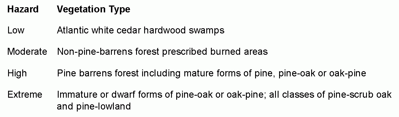
I. Fire management. All proposed development within the Pinelands Area, Jackson Township, shall conform to the requirements of this subsection in order to protect life and property from forest fires.�
(1) The following vegetation classifications shall be used in determining the fire hazard of a parcel of land:�
(2) No application for development approval shall be granted in moderate, high and extreme fire hazard areas unless the applicant demonstrates the following:�
(a) All proposed development or units or sections thereof of 25 dwelling units or more will have two accessways of a width and surface composition sufficient to accommodate and support fire-fighting equipment.�
(b) All dead-end roads will terminate in a manner which provides safe and efficient entry and exit for fire equipment.�
(c) The rights-of-way of all roads will be maintained so that they provide an effective fire break.�
(d) A fire hazard fuel break is provided around structures proposed for human use by the selective removal or thinning of trees, bushes, shrubs and ground cover as follows:�
[1] In moderate fire hazard areas, a fuel break of 30 feet measured outward from the structure, in which shrubs, understory trees and bushes and ground cover are to be selectively removed, mowed or pruned on an annual basis and in which all dead plant material is removed.�
[2] In high fire hazard areas, a fuel break of 75 feet measured outward from the structure, in which shrubs, understory trees and bushes and ground cover are to be selectively removed, mowed or pruned and maintained on an annual basis and in which all dead plant material is removed.�
[3] In extreme high-hazard areas, a fuel break of 100 feet measured outward from the structure, in which shrubs, understory trees and bushes and ground cover are to be selectively removed, mowed or pruned and maintained on an annual basis; no pine tree (Pinus species) is closer than 25 feet to another pine tree; and all dead plant material is removed.�
(e) All structures will meet the following specifications:�
[1] Roofs and exteriors will be constructed of fire-resistant materials, such as asphalt rag felt roofing, tile, slate, asbestos cement shingles, sheet iron, aluminum or brick. Fire-retardant treated wood shingles or shake-type roofs are prohibited in high or extreme fire hazard areas.�
[2] All projections, such as balconies, decks and roof gables shall be constructed of fire-resistant materials or materials treated with fire-retardant chemicals.�
[3] Any openings in the roof, attic and floor shall be screened.�
[4] Chimneys and stovepipes which are designated to burn solid or liquid fuels shall be equipped with screens over the outlets.�
[5] Flat roofs are prohibited in areas where vegetation is higher than the roof.�
(f) All residential developments of 100 dwelling units or more in high or extreme fire hazard areas will have a two-hundred-foot perimeter fuel break between all structures and the forest in which shrubs, understory trees and bushes and ground cover are selectively removed, mowed or pruned on an annual basis; all dead plant material is removed; roads, rights-of-way, wetlands and waste disposal sites shall be used as fire breaks to the maximum extent practical; and there is a specific program for maintenance.�
J. Recreation. All proposed development within the Pinelands Area, Jackson Township, shall conform to the following requirements:�
(1) No power vessel in excess of 10 horsepower shall operate on waters within the Pinelands Area, Jackson Township.�
(2) No motor vehicles, other than fire, police or emergency vehicles or those vehicles used for the administration or maintenance of any public land, shall be operated upon publicly owned land within the Pinelands Area, Jackson Township. Other motor vehicles may operate on public lands for recreational purposes, on public highways and areas on land designated prior to August 8, 1980, for such use by the State of New Jersey until designated as inappropriate for such use by the Pinelands Commission.�
(3) Route maps for organized off-road vehicle events shall be filed with an approved plan by the Executive Director.�
(4) All recreation areas and facilities shall be designed in accordance with the New Jersey Department of Environmental Protection publication, Administration Guidelines: Barrier-Free Design Standards for Parks and Recreational Facilities.�
(5) Improved bicycling facilities are provided only in conjunction with paved roads.�
K. Historical, archaeological and cultural preservation. The provisions of this subsection shall provide a program for the protection of historic, archaeological and cultural resources within the Pinelands Area, Jackson Township.�
(1) The Planning Board shall exercise all the powers and perform all the duties set forth in N.J.A.C. 7:50-6.153(a), including recommendations to the Township Committee for designation of historic resources, in accordance with N.J.S.A. 40:55D-1 et seq., which are determined to be significant, pursuant to § 244-79K(5)(c) below.�
(2) Authority to issue certificate of appropriateness.�
(a) The Planning Board shall issue all certificates of appropriateness, except as specified in § 244-79K(2)(b) below.�
(b) The Board of Adjustment shall issue certificates of appropriateness for those applications for development which it is otherwise empowered to review.�
(3) Certificates of appropriateness shall be required for the following:�
(a) Construction, encroachment upon, alteration, remodeling, removal, disturbance or demolition of any resource designated by the Township Committee or the Pinelands Commission, pursuant to N.J.A.C. 7:50-6.154, or any action which renders such a site inaccessible; and�
(b) Development not otherwise exempted from review, pursuant to § 244-67A of this Code, where a significant resource has been identified, pursuant to § 244-79K(5) below.�
(4) Applications for certificates of appropriateness shall include the information specified in N.J.A.C. 7:50-6.156(b).�
(5) Cultural resource survey.�
(a) A cultural resource survey shall accompany all applications for development in the PV, PVC-1 and PVC-2 Zones and all applications for major development in order to determine whether any significant historic resources exist on the parcel. Guidelines for this survey are contained in Appendix B of the "Cultural Resource Management Plan," dated April 1991, as amended. In general, the survey shall include: [Amended 12-30-1996 by Ord. No. 27-96]�
[1] A statement as to the presence of any properties listed on the National and State Registers of Historic Places on the site or within the area of the projects' potential environmental impacts;�
[2] A thorough search of state, local and any other pertinent inventories to identify sites of potential significance;�
[3] A review of the literature and consultation with professional and avocational archaeologists knowledgeable about the area;�
[4] Thorough pedestrian and natural resources surveys;�
[5] Archaeological testing as necessary to provide reasonable evidence of the presence or absence of historic resources of significance;�
�
[6] Adequate recording of the information gained and methodologies and sources used; and�
[7] A list of personnel involved and qualifications of the person(s) performing the survey.�
(b) This requirement for a survey may be waived by the local approval agency if:�
[1] There is insufficient evidence of significant cultural activity on the project site or, in the case of archaeological resources, within the vicinity;�
[2] The evidence of cultural activity on the site lacks the potential for importance because further recording of the available data will not contribute to a more comprehensive understanding of Pinelands culture; or�
[3] The evidence of cultural activity lacks any potential for significance, pursuant to the standards of § 244-79K(5)(c) below.�
(c) A resource shall be deemed to be significant if it possesses integrity of location, design, setting, materials, workmanship, feeling and association which reflects its significance in American history, architecture, archaeology or culture under one or more of the following criteria:�
[1] The presence of structures, sites or areas associated with events of significance to the cultural, political, economic or social history of the nation, state, local community or the Pinelands;�
[2] The presence of structures, sites or areas associated with the lives or persons or institutions of significance to the cultural, political, economic or social history of the nation, state, local community or the Pinelands;�
[3] The presence of structures that represent the work of a master or that possess high artistic values or that embody the distinctive characteristics of a type, period or method of construction or that represent a distinguishable entity of significance to the architectural, cultural, political, economic or social history of the nation, state, local community or the Pinelands, although its components may lack individual distinction; or�
[4] The presence of a site or area which has yielded or is likely to yield significant information regarding the history or archaeological history of the Pinelands.�
(6) The standards governing the issuance of certificates of appropriateness in N.J.A.C. 7:50-6.156(c) shall be followed by the Planning Board and Board of Adjustment.�
(7) The effect of the issuance of a certificate of appropriateness is as follows:�
(a) All subsequent development approvals shall be issued or denied in a manner consistent with the certificate of appropriateness, except as provided in § 244-79K(7)(b) below.�
�
(b) A certificate of appropriateness issued as a result of the cultural resource survey requirement set forth in § 244-79K(5) above shall be effective for two years. If the resource is not designated by the Pinelands Commission pursuant to N.J.A.C. 7:50-6.154 or by the governing body pursuant to N.J.S.A. 40:55D-1 et seq. within that two-year period, the historic resource standards of this section shall no longer apply to the resource in question until such time as the Pinelands Commission designates the resource pursuant to N.J.A.C. 7:50-6.154. [Amended 12-30-1996 by Ord. No. 27-96]�
(8) The following information will be required to document resources which are not found to be significant, but which are otherwise found to present graphic evidence of a cultural activity:�
(a) A narrative description of the resource and its cultural environment;�
(b) Photographic documentation to record the exterior appearance of buildings, structures and engineering resources;�
(c) A site plan depicting, in correct scale, the location of all buildings, structures and engineering resources; and�
(d) A New Jersey State inventory form, as published by the New Jersey Department of Environmental Protection, for buildings, and a narrative description of any process or technology, if necessary to elaborate upon the photographic record.�
(9) If archaeological data are discovered on a site at any time after construction has been commenced, the developer shall immediately cease construction, notify the Planning Board and the Pinelands Commission and take all reasonable steps to protect the archaeological data in accordance with the Guidelines for the Recovery of Scientific, Prehistoric, Historic and Archaeological Data: Procedures for Notification, Reporting and Data Recovery (36 CFR 66).�
L. Scenic. All proposed development within the Pinelands Area of the Township shall conform to the requirements of this subsection to ensure that development will take advantage of and enhance the visual character of the Pinelands.�
(1) Scenic corridors:�
(a) Areas considered corridors.�
[1] Except for those roads which provide for internal circulation within residentially developed areas, all public paved roads in the PA Preservation Area Zone, FA Forest Area Zone, RD Rural Development Area Zone, RD-1 Rural Development Area Zone and RD-9 Rural Development Area Zone shall be considered scenic corridors.�
[Amended 2-26-1996 by Ord. No. 4-96; 7-14-1997 by Ord. No. 10-97]�
[2] The Toms River shall be considered a special scenic corridor, and development shall comply with Subsection L(1)(b)[4] hereof.�
(b) Special requirements for scenic corridors.�
[1] Except as otherwise provided in this subsection, all buildings shall be set back at least 200 feet from the scenic corridor, except for agricultural product sales establishments, which shall be set back a minimum of 75 feet.�
[2] If compliance with the two-hundred-foot setback is constrained by environmental or other physical considerations, such as wetlands or active agricultural operations, the building shall be set back as close to 200 feet as practical, and the site shall be landscaped in accordance with the provisions of § 244-79B, Vegetation, of the Jackson Township Code, so as to provide screening from the corridor.�
[3] If an applicant for development approval demonstrates that existing development patterns of the corridor are such that buildings are set back less than 200 feet within 1,000 feet of the site proposed for development, then a setback shall be set for the proposed development which is consistent with the established development pattern, provided that the site is landscaped in accordance with the provisions of § 244-79B, Vegetation, so as to provide screening between the building and the corridor.�
[4] All structures within 1,000 feet of the center line of a special scenic corridor shall be designed to avoid visual impacts as viewed from the corridor.�
(2) Signs.�
(a) Signs in the Pinelands Area.�
[1] No sign, other than warning or safety signs, which is designed or intended to attract attention by sudden, intermittent or rhythmic movement or physical or lighting change sha ll be permitted in the Pinelands Area of the Township.�
[2] No sign, other than warning or safety signs, which changes physical position by any movement or rotation or which gives the visual impression of such movement or rotation sha ll be permitted in the Pinelands Area of the Township.�
[3] No outdoor, off-site commercial advertising sign shall be permitted in the Pinelands Area, Jackson Township, except that: [Amended 12-30-1996 by Ord. No. 27-96]�
[a] Existing lawful off-site commercial advertising signs, in existence as of January 14, 1981, shall be permitted in the RG-2, RG-3, RG-4, RGC-1, RGC-2 and PM-1 Zones. Such signs shall also be permitted in the PVC-1 and PVC-2 Zones, provided that the signs are located on a United States highway within 1,000 feet of a Pinelands Regional Growth Area or Pinelands Town; and�
[b] Signs advertising agricultural commercial establishments shall be permitted, provided that:�
[i] No more than two signs shall be placed in any one direction along each road directly approaching the establishment; and�
[ii] No sign along a four-lane state or federal highway shall exceed 50 square feet in area, and no sign along any other road shall exceed 32 square feet in area.�
[4] Any existing sign which does not conform to Subsection L(2)(a)[1] and [2] above shall be removed immediately. Any existing sign which does not conform to Subsection L(2)(a)[3] above shall be removed no later than December 5, 1996. [Amended 12-30-1996 by Ord. No. 27-96]�
[5] To the maximum extent practical, the character and composition of construction materials for all signs shall be harmonious with the scenic values of the Pinelands.�
(b) Signs in the PA Preservation Area Zone.�
[1] No sign shall be constructed, repaired or maintained except in accordance with the provisions of § 244-79L(2)(a) above and this subsection.�
[2] The following signs are permitted in the PA Preservation Area Zone:�
[a] Official public safety and information signs displaying road names, numbers and safety directions.�
[b] On-site signs advertising the sale or rental of the premises, provided that the are a on one side of any such sign shall not exceed 12 square feet and that no mor e than one sign is located on any parcel of land held in common own ership.�
[c] On-site identification signs for schools, churches, hospitals or similar public ser vice institutions, provided that the size of any such sign shall not exceed 12 square feet and that no more than one sign is placed on any single pro perty.�
[d] Trespassing signs or signs indicating the private nature of a road, dri veway or premises and signs prohibiting or otherwise controlling fishing or hunting, provided that the size of such signs does not exceed 12 square fee t.�
[e] On-site professional, home occupation or name signs indicating the profession and /or activity and/or name of the occupant of the dwelling, provided that the siz e of any such sign shall not exceed 12 square feet and that no more than one sign is permitted for any individual parcel of land.�
[f] On-site business or advertising signs, provided that no more than two sig ns are located on any one premises or on the premises leased or utilized by any one business establishment and that the total of such signs shall not exceed 20 square feet per side, with the maximum height to the top of the sign not to exceed 15 feet from ground level.�
�
[g] Temporary signs advertising political parties or candidates for election, pro vided that the size of any such sign does not exceed four square feet.�
[h] Temporary on-and-off signs advertising civil, social or political gatherings and activities, provided that the size of such signs does not exceed four squ are feet.�
(3) Motor vehicle screening and storage. No more than 10 automobiles, trucks or other motor vehicles, whether or not they are in operating condition, shall be stored on any lot, unless such motor vehicles are adequately screened from adjacent residential uses and scenic corridors. All vehicles not in operating condition shall be stored only if the gasoline tanks of such vehicles are drained. This subsection shall not apply to vehicles which are in operating condition and which are maintained for agricultural purposes.�
(4) Location of utilities.�
(a) New utility distribution lines and telephone lines to locations not presently served by utilities shall be placed underground, except for those lines which are located on or adjacent to active agricultural operations.�
(b) Aboveground generating facilities, switching complexes, pumping stations and substations shall be screened with vegetation from adjacent uses.�
(c) All electric transmission lines shall be located on existing towers or underground to the maximum extent practicable.�
M. Energy conservation. All development shall be carried out in a manner which promotes energy conservation and maximizes activities and passive solar energy, in accordance with any applicable statutes. Such measures may include orientation of buildings, landscaping to permit solar access and the use of energy-conserving building materials.�
N. Waste management. No hazardous or toxic substances, including hazardous wastes, shall be stored, transferred, processed, discharged, disposed or otherwise used in the Pinelands area. The land application of waste or waste-derived materials is prohibited in the Pinelands Area, except as expressly authorized in N.J.A.C. 7:50-6.79. Waste management facilities shall only be permitted in the Pinelands area in accordance with the standards set forth in N.J.A.C. 7:50-6.�
[Amended 12-30-1996 by Ord. No. 27-96]�

