
[Added 11-22-1988 by Ord. No. 88:65] �
Land or water falling in the following classifications are hereby designated as land constraint areas: �
A. Flood hazard area. The floodway and any additional portions of the floodplain, as defined in the Flood Hazard Protection Ordinance, Chapter 175 of the Code of the Township of Parsippany-Troy Hills. �
B. Wetlands area. Marsh, swampland and areas saturated with water as defined in the Freshwater Wetlands Protection Act, N.J.S.A. 13:9B-1 et seq. �
C. Stream area. Any body of continuously or intermittently flowing water, whether designated as a stream, brook, river or otherwise, and consisting of a bed and banks. �
D. Pond or lake area and other bodies of water. Any nonflowing body of water with a mean depth of four feet and a surface area greater than one acre, including any such areas created for retention or detention purposes and any nonflowing bodies of water with a mean depth of four feet, which, on a given tract of land, in the aggregate have a surface area greater than one acre, including any such areas created for retention or detention purposes. �
E. Critical slope areas. Any slope having a grade of 15% or greater. [Amended 3-14-2000 by Ord. No. 2000:6] �
�
A. Regulations for flood hazard and wetlands areas. Notwithstanding any other provision of the Land Use and Development Ordinance or Flood Hazard Protection Ordinance, no building, parking lot or other impervious surface shall be erected or constructed, either above or below ground level, within any flood hazard area or wetlands area in the Township of Parsippany-Troy Hills, unless a permit has been issued by the New Jersey Department of Environmental Protection pursuant to the Freshwater Wetlands Protection Act, N.J.S.A. 13:9B-1 et seq., or by the United States Army Corps. of Engineers pursuant to Section 404 of the Federal Water Pollution Control Act Amendments of 1972, as amended by the Clean Water Act of 1977 (33 U.S.C. § 1344), if the project is exempt from the provisions of the Freshwater Wetlands Protection Act. [Amended 12-13-1988 by Ord. No. 88:77] �
B. Regulations for stream, pond and lake areas. Notwithstanding any other provision of the Land Use and Development Ordinance or Flood Hazard Protection Ordinance, no building or structure shall be erected or constructed, whether above or below ground level, within 50 feet of the edge of any pond, lake or stream. Nothing herein contained, however, shall be construed to prohibit the construction and maintenance of dams or other structures for the impoundment or retention of water in any such stream, pond or lake or of dug ponds or reservoirs, provided that all applicable requirements and approvals of any public authority having jurisdiction over such matters are met and obtained. The following shall be permitted uses or activities in lake areas, provided that they do not disturb the natural and indigenous character of the areas and provided that such use is permitted and is in accordance with all other Township ordinances: �
(1) Conservation of soil, vegetation, water, fish and wildlife. �
(2) Fishing, swimming and boating. �
(3) Dock, pier, boathouse and marina construction in accordance with other provisions of all Township ordinances. �
C. Regulations for critical slope areas. All applications for subdivision or site plan approval shall be evaluated for their impact on critical slope areas as set forth herein. No buildings, improvements or structures, including roads, driveways and parking areas, shall be constructed nor shall any displacement of soil occur within critical slopes areas except in accordance with the following requirements: [Amended 3-14-2000 by Ord. No. 2000:6] �
(1) Categories of slopes; map delineations. �
(a) The following categories of slopes shall be identified on a plan drawn at a scale required as per the Township's site plan or subdivision submission requirements and showing existing and topographic elevations at two-foot contour intervals: �
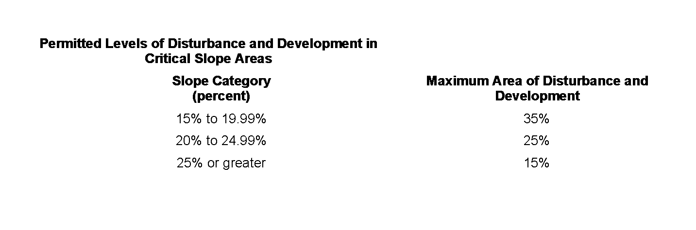
[1] Category 1 slopes: 15% to 19.99%. �
[2] Category 2 slopes: 20% to 24.99%. �
�
[3] Category 3 slopes: 25% or greater. �
(b) The map shall also delineate those areas proposed for clearing, regrading and development; the location of all existing and proposed wells and septic systems; the location of all trees in excess of six inches in caliper and contiguous wooded areas; and soil types contained on the lot with specific reference to highly erodible soils as defined by the United States Department of Agriculture Soil Conservation Service. �
(2) In platting a parcel for subdivision and siting proposed development, the applicant shall avoid disturbance of critical slope areas to the greatest extent practical. Limited disturbance and development of critical slope areas is permitted in accordance with the following schedule: �
(3) Disturbance of critical slope areas in an amount greater than indicated in § 225-80C(2) shall require a variance. �
(4) The Planning Board or Zoning Board of Adjustment may permit the disturbance and development of small isolated pockets of critical slopes that are under 1,000 square feet in area. Such disturbance may be permitted if the Board determines that the disturbance of the critical slope area is consistent with sound planning and promotes the goals and objectives of the Township's Master Plan; would not substantially impair the purposes of the Township's Zoning and Land Use Ordinances; and would otherwise result in practical difficulties for the applicant. Where the Board determines that such pocket or pockets are proximate to other critical slope areas and collectively are of such size to constitute a significant and substantially contiguous area, the Board may determine that the area is subject to the requirements of this section. �
(5) These requirements shall not apply to any development for which preliminary major subdivision approval, preliminary major site plan approval, final subdivision approval or final site plan approval was granted by a resolution of approval adopted by the Planning Board prior to the adoption of this provision, and which approval has not expired. In such cases, the requirements and conditions contained in the resolution of approval shall apply. �
A. Where an applicant demonstrates through topographic maps or soil tests, whichever is applicable, and such proof is confirmed through on-site inspection by the Township Engineer and the Morris County Soil Conservation District that a property is misclassified and is not in a land constraint area, then the Construction Official or Board considering the application may grant full or partial relief from the regulations of this article. �
B. Requests for waivers from the land constraints regulations shall be made at the time of application. The applicant requesting such a waiver shall be required to demonstrate that the proposed construction will have no detrimental effects upon the land or surrounding area. The Construction Official, on the recommendation of the Township Engineer or the Board considering the application, may grant full or partial relief from the regulations of this article. �

