
a. Official Zoning Map.�
1. The locations and boundaries of the zoning districts of the Borough are hereby established as shown on the Official Zoning Map of the Borough of Red Bank, New Jersey, which is attached hereto and is hereby made a part of this ordinance, together with all notations, references and designations shown thereon. This Map was prepared by Richard A. Kosenski, P.E., P.P., T & M Consulting Engineers and last revised 7/99.�
2. Authentication of Official Zoning Map. Subsequent to the adoption of this Chapter, the original copy of the Official Zoning Map shall be authenticated by the Mayor's signature, and the seal of the municipality, attested by the Borough Clerk, under the following certificate:�
"I certify that this is the official Zoning Map of the Borough of Red Bank, New Jersey, referred to in the Codified Ordinances of the Borough of Red Bank, New Jersey."�
3. Maintenance of the Official Zoning Map. Said original copy of the Official Zoning Map shall be maintained in the office of the Borough Clerk, and shall be made available for public reference. Copies of all or a part of the Official Zoning Map may be reproduced for public distribution. However, the original copy of the Official Zoning Map maintained in the office of the Borough Clerk shall be the final authority as to the current status of zoning districts in the Borough of Red Bank.�
4. Changes to the Official Zoning Map.�
(a) When, in accordance with the provisions of this Ordinance and of State Law, changes are made in district boundaries or other matters portrayed in the Official Zoning Map, such changes will not become effective until the Official Zoning Map has been amended, with an entry bearing the following notation:�
"On ___________ by Ordinance adopted on ______________ the governing body made the following change(s) in the Official Zoning Map:�
(Brief description of change)."�
(b) Each such entry shall be signed by the Mayor and attested by the Borough Clerk. Each Ordinance amending the Official Zoning Map in any manner shall include the provision that it shall not take effect until the Official Zoning Map has been amended in accordance with these provisions.�
(c) No changes of any nature shall be made to the Official Zoning Map except in conformity with the above procedure. Any unauthorized changes to the Map or its contents by any person or persons shall be considered a violation of this Chapter.�
b. Interpretation of District Boundaries.�
1. Zone district boundaries are intended to follow street, lot or property lines, or other natural lines such as the center line of water courses, ditches or lagoons, unless such district or zone boundaries are fixed by dimension on the Zoning Map or by description, and shall include contiguous riparian lands subsequently acquired and/or filled, and lands acquired by accretion or stream diversion by natural causes.�
2. In constructing the Official Zoning Map, the following rules shall apply:�
(a) Boundaries indicated as following the center lines of streets, highways or alleys or streams, rivers or other bodies of water shall be construed to follow such center lines.�
(b) Boundaries indicated as approximately following platted lot lines shall be construed as following such lot lines.�
(c) Boundaries indicated as following railroad lines shall be construed to be midway between the main tracks.�
(d) Boundaries indicated as parallel to or extensions of features indicated in paragraphs 1. through 3. above, shall be so construed. Distances not specifically indicated on the Official Zoning Map shall be determined by the use of the scale appearing thereon.�
(e) Where a zone district boundary fixed by dimensions approximately follows and is not more than twenty (20') feet distant from a lot line, such lot line shall be construed to be the zone boundary.�
(Ord. #686, S 13-10.1; Ord. #1999-36, S 1; Ord. #2003-41 S 1; Ord. #2004-12, S 1)�
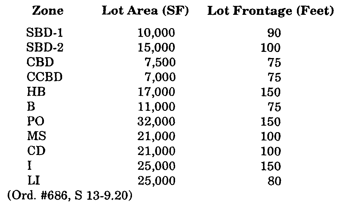
a. The Borough of Red Bank is hereby divided into districts as follows:�
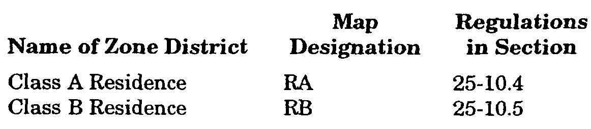
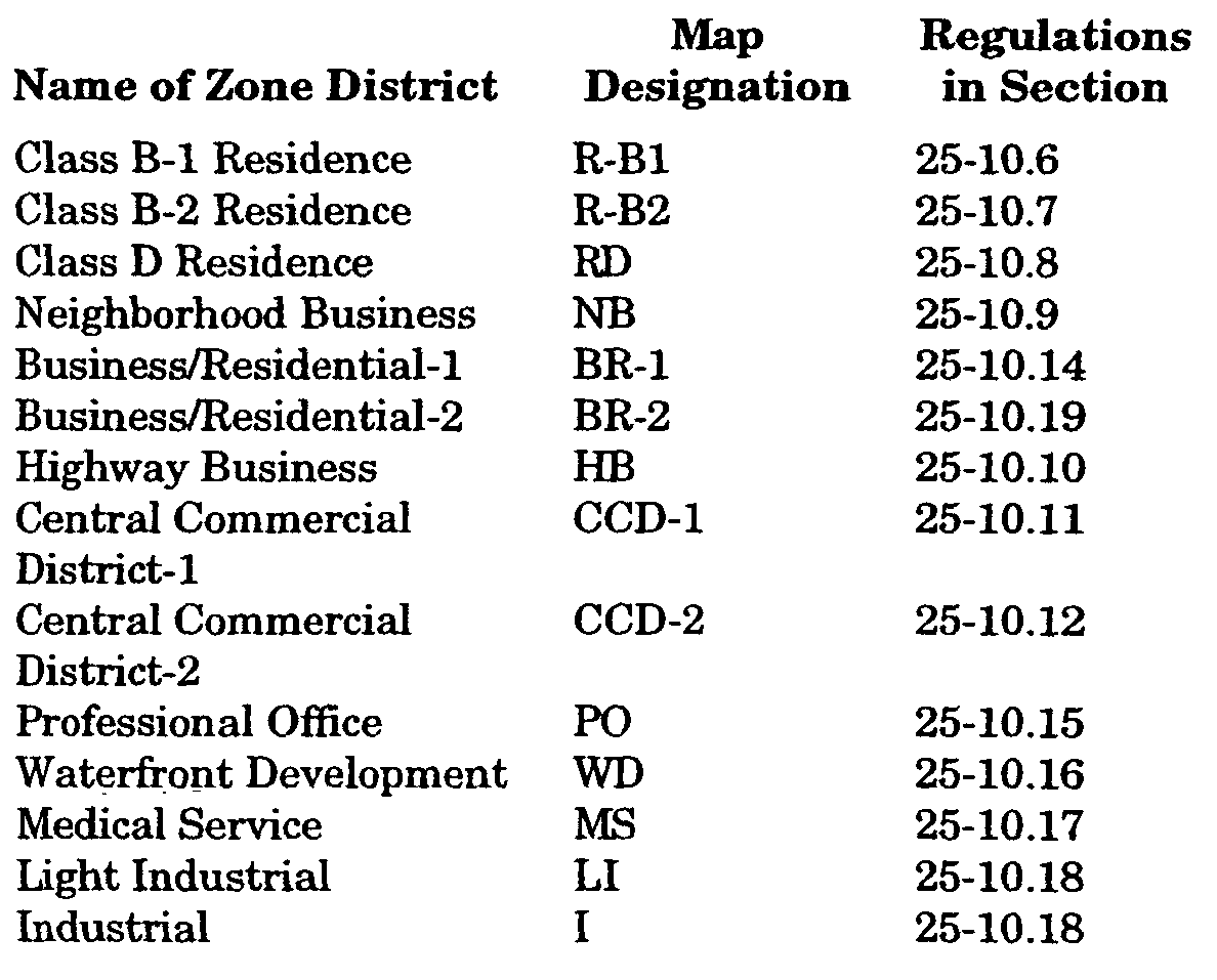
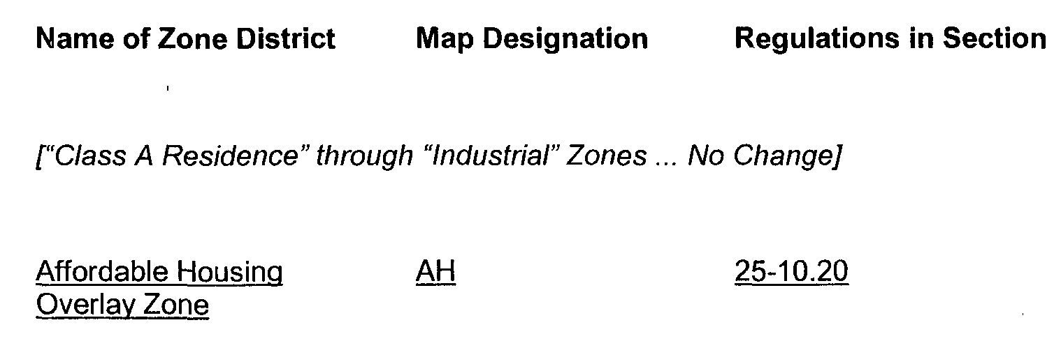
**Webmasters Note: The table above has been amended as per Ordinance NO. 2006-53�
b. The regulations set forth in this Chapter for each district shall be minimum regulations and shall apply uniformly to each class of structure or land within the district, except as hereinafter provided.�
c. No structure shall hereafter be erected and no existing, structure shall be moved, altered, added to or enlarged, nor shall any land or building or portion of a building to be used, designed, or arranged to be used for any purpose unless in conformity with all of the regulations herein specified for the district in which it is located.�
d. Every main structure shall be located on a lot as defined in this Chapter. Except for planned development groups complying with all the regulations applying thereto as prescribed by this Chapter, no more than one (1) single or two (2) family dwelling building and its accessory buildings shall hereafter be erected on any one (1) lot.�
e. No yard or lot existing at the time of passage of this Chapter shall be reduced in dimension or area below the minimum requirements set forth herein. Yards or lots created after the effective date of this Chapter shall meet the minimum requirements established by this Chapter.�
(Ord. #686, S 13-10.2; Ord. #1998-4; Ord. #1998-33; Ord. #2003-41, S 5)�
a. Any use not specifically listed as a permitted use, an accessory use or a conditional use shall be deemed a prohibited use. This prohibition shall be liberally construed as protective of the zoning scheme and any doubt shall be resolved in interpreting the doubtful use as prohibited.�
b. Mixed use developments, which combine those uses that are permitted individually in a particular zone district in a single development, are permitted subject to:�
1. The greatest or most restrictive area, yard and structure requirements, as set forth for any individual use, shall apply to the reused use development.�
2. All design standards, particularly the provisions of Subsection 25-8.21p. shall apply.�
3. These combinations of uses are not permitted (and will require Zoning Board of Adjustment approval pursuant to Subsection 25-3.2j.1(d):�
(a) Uses permitted only in the Industrial (I) Zone with any other use.�
(b) Mortuary and funeral homes with any other use.�
(c) Detached or single-family dwellings or detached two (2) family dwellings with any nonresidential use.�
(d) Multi-family dwellings with:�
(1) Primary food service establishments.�
(2) Banks and financial institutions offering driveup service.�
(3) Primary liquor service establishments.�
(Ord. #686, S 13-10.3; Ord. #1996-6, S 1; Ord. #1997-6, S 1; Ord. #1997-12, S 1; Ord. #2003-41, S 4)�
a. Permitted Uses.�
1. Detached single family dwellings.�
2. Essential services.�
b. Required Accessory Uses.�
1. Off-street parking subject to the provisions of Subsection 25-8.21.�
�
c. Permitted Accessory Uses.�
1. Fences and hedges subject to the provisions of Subsection 25-8.14.�
2. Private garage space for the storage of motor vehicles, provided that said garage, whether attached or detached, shall be arranged to open to the side or rear of the lot unless detached and located entirely to the rear of the principal building.�
3. Minor and type A signs subject to the provisions of Subsection 25-8.27.�
4. Swimming pools - Subject also to Chapter XIV, Swimming Pools and Subsection 25-8.14 of this Chapter.�
5. Other customary residential accessory uses and buildings subject to Subsection 25-5.8 of this Chapter, provided such uses are incidental to the principal use and do not include any activity commonly conducted as a business. Any such accessory building or use shall be located at the same lot as the principal building.�
6. Personal earth terminals subject to the provisions of Subsection 26-8.36.�
d. Conditional Uses: Subject to the Provisions of Section 25-9 of this Chapter.�
1. Churches and places of worship.�
2. Educational uses.�
3. Public and quasi-public recreation areas.�
4. Nursery schools.�
5. Public utilities.�
1. Minimum Lot Area:�
(a) six thousand five hundred (6,500) square feet.�
�
(b) For lots abutting the Navesink River, forty thousand (40,000) square feet.�
**Webmasters Note: The subsection above (b) has been added as per Ordinance No. 2007-15.�
�
2. Minimum Lot Frontage: seventy-five (75') feet.�
3. Minimum Front Setback: thirty (30') feet, except in no case shall any structure be less than forty (40') feet from the center line of the street.�
(a) Principal structure - twenty-five (25') feet.�
(b) Accessory structure - eight (8') feet.�
(a) Principal structure - twelve (12') feet, except that the combination of both side yards must be at least thirty (30') feet.�
(b) Accessory structure - eight (8') feet.�
6. Maximum Structure Height: thirty-five (35') feet and not exceeding two and one-half (2 1/2) stories.�
7. Minimum Gross Habitable Floor Area:�
(a) One (1) story - one thousand five hundred (1,500) square feet.�
(b) Two (2) story - one thousand five hundred (1,500) square feet with at least eight hundred (800) square feet of ground floor area.�
8. Maximum Lot Coverage of Principal and Accessory Structures: thirty-five (35%) percent.�
f. Special Requirements.�
1. All applications for development in this zone on properties abutting or contiguous with the Navesink River and which require submission of a major site plan, will be accompanied by an Environmental Impact Report (EIR) as provided for in Subsection 25-8.13 of this Chapter.�
2. All applications for development in this zone on properties abutting or contiguous with the Navesink River and which require submission of a major or minor site plan or major subdivision, will include maximum practical provisions for public access to the Navesink River. Unless waived by the Municipal Agency, these provisions will include:�
(a) An access easement of twenty-five (25') foot minimum width along all river frontage; and�
(b) Appropriate provisions for passive enjoyment of river views by residents and the general public;�
3. Major subdivisions are subject to the Cluster (Reduced Lot Site) Development provisions pursuant to Subsection 25-5.31.�
(Ord. #686, S 13-10.4; Ord. #1996-6, S 2; Ord. #1998-27, S 3; Ord. #1999-6, S 7)�
a. Permitted Uses.�
1. Detached single family dwellings.�
2. Essential services.�
b. Required Accessory Uses.�
1. Off-street parking subject to the provisions of Subsection 25-8.21.�
c. Permitted Accessory Uses.�
1. Fences and hedges subject to the provisions of Subsection 25-8.14.�
2. Private garage space for the storage of motor vehicles, provided that said garage, whether attached or detached, shall be arranged to open to the side or rear of the lot unless detached and located entirely to the rear of the principal building.�
3. Minor and type A signs subject to the provisions of Subsection 25-8.27.�
4. Swimming pools subject also to Chapter XIV, Swimming Pools, and Subsection 25-8.22.�
5. Other customary residential accessory uses and buildings subject to Subsection 25-5.8 of this Chapter, provided such uses are incidental to the principal use and do not include any activity commonly conducted as a business. Any such accessory building or use shall be located at the same lot as the principal building.�
6. Personal earth terminals subject to the provisions of Subsection 25-8.36.�
d. Conditional Uses: Subject to the Provisions of Section 25-9 of this Chapter.�
1. Churches and places of worship.�
2. Educational uses.�
3. Public and quasi-public recreation uses.�
�
4. Nursery schools.�
5. Public utilities.�
1. Minimum Lot Area: three thousand five hundred (3,500) square feet.�
2. Minimum Lot Frontage: fifty (50') feet.�
3. Minimum Front Setback: thirty (30') feet, except in no case shall any structure be less than forty (40') feet from center line of a street.�
(a) Principal structure - twenty-five (25') feet.�
(b) Accessory structure - eight (8') feet.�
(a) Principal structure - ten (10') feet, except that the combination of both side yards must be at least twenty (20') feet.�
(b) Accessory structure - five (5') feet.�
6. Maximum Structure Height: thirty-five (35') feet and not exceeding two and one-half (2 1/2) stories.�
7. Minimum Gross Habitable Floor Area:�
(a) One (1) story - nine hundred (900) square feet.�
(b) Two (2) story - one thousand (1,000) square feet with at least seven hundred (700) square feet of ground floor area.�
8. Maximum Lot Coverage of Principal and Accessory Structures: forty (40%) percent.�
(Ord. #686, S 13-10.5; Ord. #1996-6, S 2; Ord. #1998-27, S 3)�

