
(a) Stormwater runoff shall be calculated in accordance with the following:�
(1) The design engineer shall calculate runoff using one of the following methods:�
a. The USDA Natural Resources Conservation Service (NRCS) methodology, including the NRCS Runoff Equation and Dimensionless Unit Hydrograph, as described in the NRCS National Engineering Handbook Section 4 - Hydrology and Technical Release 55 - Urban Hydrology for Small Watersheds; or�
b. The rational method for peak flow and the modified rational method for hydrograph computations.�
(2) The design engineer shall utilize the DelMarVa Unit Hydrograph (peak rate factor of 285) in agricultural watersheds in the coastal plain areas of the Township of South Brunswick, that are categorized by flat topography (slopes less than five percent), porous soils, low relief, and significant surface storage in swales and depressions, as stated in the Natural Resources Conservation Service New Jersey Bulletin No. NJ210-3-1. The NRCS Standard Unit Hydrograph should be used in all other areas where the DelMarVa Unit Hydrograph does not apply.�
(3) For the purpose of calculating runoff coefficients and groundwater recharge, there is a presumption that the pre-construction condition of a site or portion thereof is a wooded land use with good hydrologic condition. The term "runoff coefficient" applies to both the NRCS methodology at subsection 62-2575(a)(1)a. and the rational and modified rational methods at subsection 62-2575(a)(1)b. A runoff coefficient or a groundwater recharge land cover for an existing condition may be used on all or a portion of the site if the design engineer verifies that the hydrologic condition has existed on the site or portion of the site for at least five years without interruption prior to the time of application. If more than one land cover have existed on the site during the five years immediately prior to the time of application, the land cover with the lowest runoff potential shall be used for the computations. In addition, there is the presumption that the site is in good hydrologic condition (if the land use type is pasture, lawn, or park), with good cover (if the land use type is woods), or with good hydrologic condition and conservation treatment (if the land use type is cultivation).�
(4) In computing preconstruction stormwater runoff, the design engineer shall account for all significant land features and structures, such as ponds, wetlands, depressions, hedgerows, or culverts, that may reduce preconstruction stormwater runoff rates and volumes.�
(5) In computing stormwater runoff from all design storms, the design engineer shall consider the relative stormwater runoff rates and/or volumes of pervious and impervious surfaces separately to accurately compute the rates and volume of stormwater runoff from the site. To calculate runoff from unconnected impervious cover, urban impervious area modifications as described in the NRCS Technical Release 55 - Urban Hydrology for Small Watersheds and other methods may be employed.�
(6) If the invert of the outlet structure of a stormwater management measure is below the flood hazard design flood elevation as defined at N.J.A.C. 7:13, the design engineer shall take into account the effects of tailwater in the design of structural stormwater management measures.�
(b) Groundwater recharge may be calculated in accordance with the following: The New Jersey Groundwater Recharge Spreadsheet (NJGRS), a Microsoft Excel-based computer spreadsheet program. The NJGRS program is available for download at the NJDEP Stormwater Management website. (Ord. No. 2007-15, § I, 3-27-2007)�
(a) General standards for structural stormwater management measures are as follows:�
(1) Structural stormwater management measures shall be designed to take into account the existing site conditions, including, for example, environmentally critical areas, wetlands; flood-prone areas; slopes; depth to seasonal high water table; soil type, permeability and texture; drainage area and drainage patterns.�
(2) Structural stormwater management measures shall be designed to minimize maintenance, facilitate maintenance and repairs, and ensure proper functioning. Trash racks shall be installed at the intake to the outlet structure as appropriate, and shall have parallel bars with one-inch spacing between the bars to the elevation of the water quality design storm. For elevations higher than the water quality design storm, the parallel bars at the outlet structure shall be spaced no greater than one-third the width of the diameter of the orifice or one-third the width of the weir, with a minimum spacing between bars of one inch and a maximum spacing between bars of six inches. In addition, the design of trash racks must comply with the requirements of subsection 62-2578(b).�
(3) Structural stormwater management measures shall be designed, constructed, and installed to be strong, durable, and corrosion resistant. Measures that are consistent with the relevant portions of the residential site improvement standards at N.J.A.C. 5:21-7.3, 7.4, and 7.5 shall be deemed to meet this requirement.�
**Webmasters Note: The previous sections, 62-2574(g)(7)d. through 62-2576(a)(3), have been amended as per Supplement No. 10.�
(4) At the intake to the outlet from the stormwater management basin, the orifice size shall be a minimum of 2112 inches in diameter.�
(5) Stormwater management basins shall be designed to meet the minimum safety standards for stormwater management basins at section 62-2578.�
(6) Where physically feasible, drywells shall be used to receive and infiltrate stormwater runoff from all roof areas.�
(7) All stored stormwater runoff shall discharge from any structural stormwater management measure (basins, dry wells, etc.) within 72 hours commencing at the end of the storm event.�
(8) All stormwater management basins that are part of a residential subdivision application shall be located on an individual lot that is reserved specifically for such use and that is dedicated to the Township of South Brunswick or a private entity, such as a homeowner's association, for ownership and maintenance of said facility. The owner or tenant of an individual dwelling property within a residential development shall not be assigned or transferred ownership and maintenance responsibilities for any stormwater management basin, unless such owner or tenant owns or leases the entire residential development or project.�
(9) Stormwater management basins may be located on the same lot as the principal use, provided said principal use is not an individual dwelling property, said lot is privately owned, said basin serves only the property on which it is located, and a stormwater maintenance plan and agreement are on file with the Township.�
(10) All basins shall meet the setback requirements as set forth in subsection (b) of this section. Stormwater management basins shall not traverse any proposed or existing lot lines.�
(11) The 100-year water surface elevation in all stormwater management basins and facilities shall be located a minimum of one foot below any adjacent proposed and existing basement floor elevations.�
(b) Standards for dry detention basins are as follows:�
(1) Side slopes shall be a maximum of one vertical to three horizontal.�
(2) The basin bottom shall be as follows:�
a. Transverse slope (to low flow channel); minimum of two percent.�
b. Low flow channel if sodded; minimum slope of two percent. �
�
c. Low flow channel if concrete; minimum slope of one-half percent.�
(3) An area 15 feet wide with a cross slope of two percent shall be constructed at the top of the bank surrounding the basin.�
(4) To provide accessibility to the bottom, an area with a minimum width of 18 feet and having a slope no greater than 1:4 shall be constructed.�
(5) If the areas described in subsections 62-2576(b)(3) or 62-2576(b)(4) require stabilization, they shall be stabilized by grass paving blocks or other suitable means subject to approval by the township engineer and director of public works.�
(6) All storm sewer outlets shall be at the grade of the basin's bottom.�
(7) All stabilization of conduit outlets shall be by grouted riprap or concrete.�
(8) The top of the basin excavation or the toe of the outside slope shall be set back 25 feet from adjoining nonresidential property lines and street right-of-way lines and 50 feet from an adjoining property line of a lot or, which there is a residential SP The edge of the design high water for detention basins shall be set back 100 feet from existing or proposed dwelling units.�
(9) Vegetative stabilization cover shall be provided throughout the basin, and landscaping shall be provided on the perimeter. Landscaping may be provided within the basin as recommenced in Chapter 7 of the New Jersey Stormwater Best Management Practices Manual, and subject to approval by the township director of public works.�
(10) The basin floor elevation shall be located at least one foot above the seasonal high groundwater table.�
(c) Standards for infiltration basins are as follows:�
(1) Where applicable, the standards for dry detention basins, as set forth in subsection (b) of this section, shall be required for infiltration basins.�
(2) The basin floor (bottom of six-inch sand layer) elevation shall be located at least two feet above the seasonal high groundwater table.�
(3) The minimum design permeability rate of the soils below the infiltration basin shall be 0.5 inches per hour.�
(4) Construction of the infiltration basin shall not compact the soils below the sand layer.�
(5) The infiltration basin shall be provided with an alternate gravity discharge measure for emergency basin drainage, such as plugged outlet pipes in place at the basin floor elevation. The infiltration basin floor elevation shall be located above waterways or storm sewers in the area to allow for this requirement. Manual valves are optional. The alternate discharge measure shall be designed to empty the volume of stored stormwater from the maximum design storm within 72 hours.�
(d) Standards for retention basins (wet ponds) are as follows:�
(1) Where applicable, the standards for dry detention basins, as set forth in subsection (b) of this section, shall be required for retention basins.�
(2) Where a retention basin is to be constructed, the applicant shall provide an environmental study which includes the following:�
a. Inflow water volume and rates from storm runoff groundwater elevations.�
b. Inflow water quality, to include runoff from parking lots, streets and roofs. Sources of pollution shall be identified.�
c. Basin floor soils; impervious strata is required.�
d. Aeration requirements (dissolved oxygen). Basins with on-site inflow only may require supplementary aeration.�
e. Aquatic vegetation requirements.�
(3) The permanent pool water surface elevation shall be located at least two feet above the seasonal high groundwater table.�
(4) The permanent pool shall be between four feet and six feet deep.�
(5) The outlet structure shall be provided with a bottom drain pipe and valve, sized to drain the permanent pool within 40 hours.�
(e) Standards for dry wells are as follows:�
(1) All dry wells shall be designed to have sufficient storage capacity to contain the larger of the following stormwater runoff volumes from the area contributory to the dry well:�
a. The total post-construction increase in runoff resulting from the 2-year 24-hour design storm.�
b. The total runoff volume resulting from the stormwater quality design storm (1.25 inches of rainfall in two hours).�
(2) All dry wells must fully drain the total design runoff volume within 72 hours.�
(3) The bottom of all dry wells must be located at least two feet above the seasonal high groundwater table.�
(4) All dry wells shall be located a minimum of 50 feet from any proposed or existing basement walls.�
(f) Additional stormwater management measure requirements are indicated in the New Jersey Stormwater Best Management Practices Manual. Other stormwater management measures may be utilized provided the design engineer demonstrates that the proposed measure and its design will accomplish the required water quantity, groundwater recharge and water quality design and performance standards established by section 62-2574 and this article.�
(g) Manufactured treatment devices may be used to meet the requirements of section 62-2574, provided the pollutant removal rates are verified by the New Jersey Corporation for Advanced Technology and certified by the department. (Ord. No. 2007-15, § I, 3-27-2007)�
(a) Technical guidance for stormwater management measures can be found in the documents listed at (1) and (2) below, which are available from Maps and Publications, New Jersey Department of Environmental Protection, 428 East State Street, P.O. Box 420, Trenton, New Jersey, 08625; telephone (609) 777-1038.�
(1) Guidelines for stormwater management measures are contained in the New Jersey Stormwater Best Management Practices Manual, as amended. Information is provided on stormwater management measures such as: bioretention systems, constructed stormwater wetlands, dry wells, extended detention basins, infiltration structures, manufactured treatment devices, pervious paving, sand filters, vegetative filter strips, and wet ponds.�
(2) The New Jersey Department of Environmental Protection Stormwater Management Facilities Maintenance Manual, as amended.�
(b) Additional technical guidance for stormwater management measures can be obtained from the following:�
(1) The "Standards for Soil Erosion and Sediment Control in New Jersey" promulgated by the State Soil Conservation Committee and incorporated into N.J.A.C. 2:90. Copies of these standards may be obtained by contacting the State Soil Conservation Committee, P.O. Box 330, Trenton, New Jersey 08625; (609) 292-5540; or the Freehold Soil Conservation District, 4000 Kozloski Road, Freehold, NJ 07728; (732) 683-8500; and�
(2) The Rutgers Cooperative Extension Service, 732-932-9306. (Ord. No. 2007-15, § I, 3-27-2007)�
�
(a) This section sets forth requirements to protect public safety through the proper design and operation of stormwater management basins. This section applies to any new stormwater management basin.�
(b) Requirements for trash racks, overflow grates and escape provisions.�
(1) A trash rack is a device designed to catch trash and debris and prevent the clogging of outlet structures. Trash racks shall be installed at the intake to the outlet from the stormwater management basin to ensure proper functioning of the basin outlets in accordance with the following:�
a. The trash rack shall be designed so as not to adversely affect the hydraulic performance of the outlet pipe or structure.�
b. The average velocity of flow through a clean trash rack is not to exceed 2.5 feet per second under the full range of stage and discharge. Velocity is to be computed on the basis of the net area of opening through the rack.�
c. The trash rack shall be constructed and installed to be rigid, durable, and corrosion resistant, and shall be designed to withstand a perpendicular live loading of 300 lbs/ft sq.�
(2) An overflow grate is designed to prevent obstruction of the overflow structure. If an outlet structure has an overflow grate, such grate shall meet the following requirements:�
a. The overflow grate shall be secured to the outlet structure but removable for emergencies and maintenance.�
b. The overflow grate spacing shall be no less than two inches across the smallest dimension.�
c. The overflow grate shall be constructed and installed to be rigid, durable, and corrosion resistant, and shall be designed to withstand a perpendicular live loading of 300 lbs./ft sq.�
(3) For purposes of this paragraph (3), escape provisions means the permanent installation of ladders, steps, rungs, or other features that provide easily accessible means of egress from stormwater management basins. Stormwater management basins shall include escape provisions as follows:�
a. If a stormwater management basin has an outlet structure, escape provisions shall be incorporated in or on the structure. With the prior approval of the development review board identified in section 62-2578(c) a freestanding outlet structure may be exempted from this requirement.�
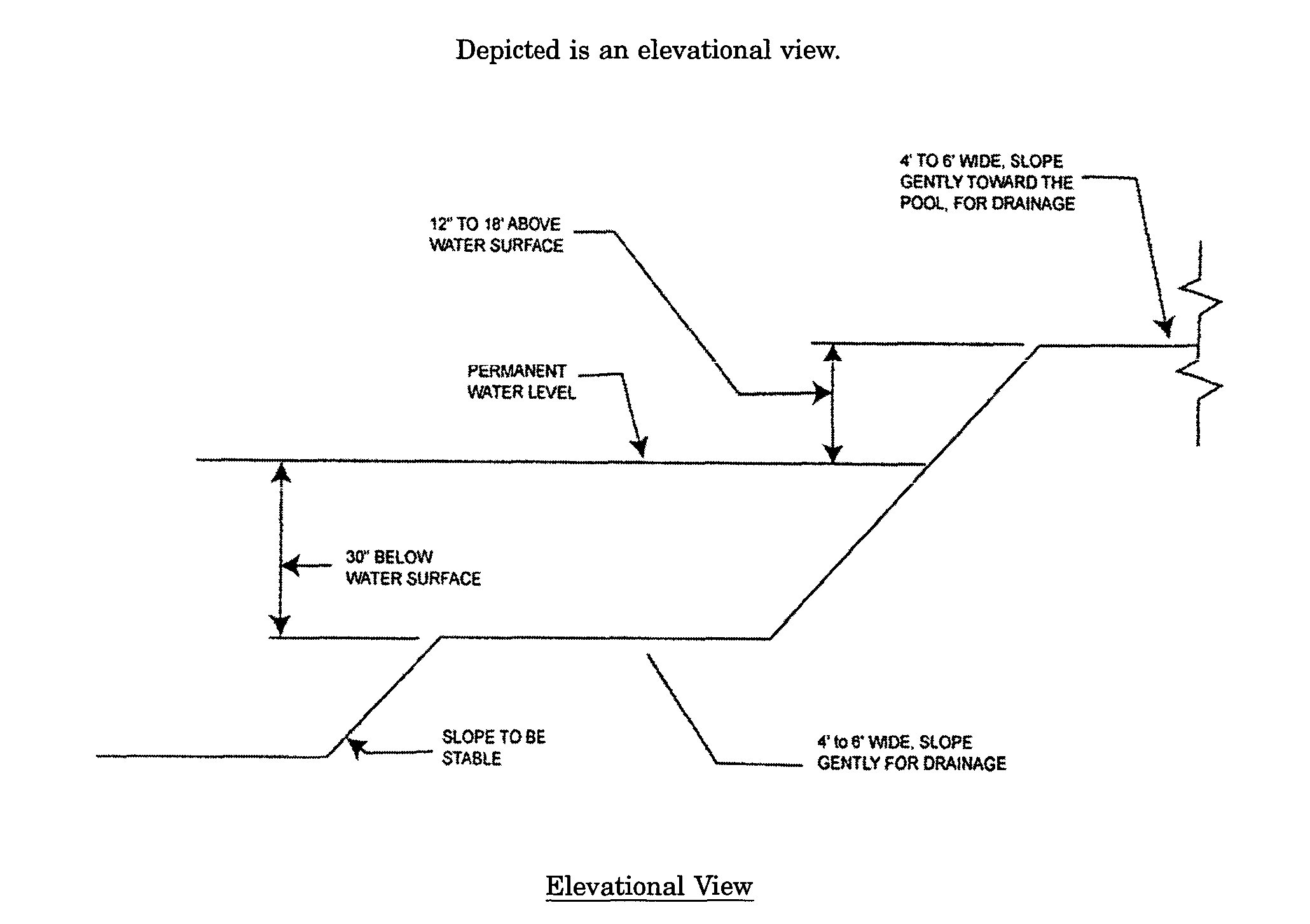
b. Safety ledges shall be constructed on the slopes of all new stormwater management basins having a permanent pool of water deeper than 2 1/2 feet. Such safety ledges shall be comprised of two steps. Each step shall be four to six feet in width. One step shall be located approximately 2 1/2 feet below the permanent water surface, and the second step shall be located one to 11/2 feet above the permanent water surface. See section 62-2578(d) for an illustration of safety ledges in a stormwater management basin.�
c. In new stormwater management basins, the maximum interior slope for an earthen dam, embankment, or berm shall not be steeper than 3 horizontal to 1 vertical.�
(c) Variance or exemption from safety standards. A variance or exemption from the safety standards for stormwater management basins may be granted only upon a written finding by the development review board that the variance or exemption will not constitute a threat to public safety.�
(d) Illustration of safety ledges in a new stormwater management basin.�
Note: Not drawn to scale�
Note: For basins with permanent pool of water only (Ord. No. 2007-15, § I, 3-27-2007)�
(a) Submission of site development stormwater plan.�
(1) Whenever an applicant seeks development review board approval of a development subject to this article, the applicant shall submit all of the required components of the checklist for the site development stormwater plan at subsection 62-2579(c) below as part of the submission of the applicant's application for subdivision or site plan approval.�
(2) The applicant shall demonstrate that the project meets the standards set forth in this article.�
(3) The applicant shall submit five copies of a site development stormwater plan, prepared, signed and sealed by a New Jersey Licensed Professional Engineer, which contains all of the materials listed in the checklist for site development stormwater plans in accordance with subsection 62-2579(c).�
(4) No application for development shall be deemed complete unless the township engineer has certified to the development review board that the applicant has provided the board with sufficient information for it to determine whether or not the proposed development will conform to Township of South Brunswick stormwater control standards.�
(b) Site development stormwater plan approval.�
(1) Site Development Stormwater Plans shall be reviewed by the development review board, which may receive the advice and assistance of the township engineer, the Freehold Soil Conservation District, the Middlesex County Mosquito Control Commission and the township environmental commission. The development review board's consideration of applications shall be guided by but not limited to the following factors:�
a. The suitability and effectiveness of the stormwater plan, including the maintenance and repair plan.�
b. The existing topography, vegetation, hydrologic factors and soil conditions.�
c. The groundwater supply, groundwater recharge and discharge areas, wet soils and the depth to the seasonal high water table.�
d. The natural drainage flow and pattern.�
e. Rainfall intensity and duration for all applicable design storms.�
f. Critical and environmentally sensitive areas on the site.�
g. Land uses in both the immediate vicinity of the site and the surrounding drainage region.�
h. Other applicable environmental, resource or public health protection ordinances, statutes or regulations.�
(2) Development review board approval shall be obtained in accordance with the following:�
a. The site development stormwater plan or any major amendment thereof, shall be approved by the development review board in the manner and form and according to the regulations set forth in this article.�
b. The development review board, in approving the site development stormwater plan, may impose lawful conditions or requirements designated or specified on or in connection therewith. These conditions and requirements shall be provided and maintained as a condition of the establishment, maintenance and continuance of any use or occupancy of any structure or land.�
(c) Checklist requirements. The following information shall be required:�
(1) Drainage area maps. Predevelopment and postdevelopment drainage area maps at a scale no smaller than one inch equals 100 feet and indicating soil types and hydrologic soil groups, vegetative cover types and hydrologic conditions, impervious areas, existing and proposed contours at two-foot intervals for slopes in excess of five percent and one-foot intervals for land of lesser slope, drainage pattern arrows, streams and associated buffer areas, open waters, wetlands and transition areas, flood hazard areas, boundaries of individual drainage areas with contributory area shown in acres, location and size of all proposed measures for stormwater runoff control, location and size of existing downstream drainage facilities, and time of concentration travel paths for all flow segments through the site. The drainage area maps shall include all upland watershed areas that drain through the site.�
(2) Narrative description. A narrative description that discusses the methods used for calculation of stormwater runoff from all on-site and upland drainage areas. In addition, the narrative description should address all required and proposed measures for stormwater management and sediment control and the sequence of installation of the stormwater management measures as related to the progress of the project.�
(3) Maintenance agreement. A maintenance or escrow agreement in accordance with the provisions of section 62-2581.�
(4) Soils report. A soils report that is based on a site investigation of subsurface conditions and that includes soil logs, depth of groundwater evaluation, with reference to proposed basement floor elevations, permeability test results and other investigations as needed for proper review of the site development stormwater plan.�
(5) Engineering calculations. Comprehensive hydrologic and hydraulic design calculations that address rate and volume of runoff from the site under both the predevelopment and postdevelopment conditions, design of the stormwater collection system, sizing of the stormwater management facilities, capacity of existing downstream drainage facilities, and compliance with the water quantity, water quality and recharge requirements of this article.�
(6) Engineering plans. Engineering plans and details of all components of the stormwater management facilities, including both structural and non-structural measures and sediment control, and indicating areas where alterations occur in the natural terrain and vegetative cover, and seasonal high groundwater elevations indicated in all required areas.�
(7) Engineer's statement. A written statement by a NJ Licensed Professional Engineer shall be submitted, certifying that the proposed site development stormwater plan will meet all applicable standards as set forth in the Township of South Brunswick Stormwater Control Ordinances.�
(8) Maintenance and repair plan. A comprehensive maintenance and repair plan for the stormwater management measures incorporated into the development of the site in accordance with Sec. 62-2581.�
(9) Land use planning and source control plan. This plan shall provide a demonstration of how the goals and standards of sections 62-2573 through 62-2576 are being met. The focus of this plan shall be to describe how the site is being developed to meet the objective of controlling groundwater recharge, stormwater quality and stormwater quantity problems at the source by land management and source controls whenever possible.�
(10) NJDEP Non-Structural Stormwater Management Strategies Point System (NSPS). Detailed calculations that demonstrate if sufficient non-structural stormwater management measures have been utilized for the project. The NSPS forms and user guide may be obtained from the address identified in section 62-2577 or found on the NJDEP website at www.njstormwater.org.�
(11) Waiver from submission requirements. The development review board reviewing an application under this article may, in consultation with the township engineer, waive submission of any of the requirements in subsections 62-2579(c)(1) through 622579(c)(10) when it can be demonstrated that the information requested is impossible to obtain or it would create a hardship on the applicant to obtain and its absence will not materially affect the review process. (Ord. No. 2007-15, § I, 3-27-2007)�

