(a) Application requirements. The applicant for final approval of a major subdivision shall file the following documents with the secretary of the municipal agency:�
(1) Final plat. Sixteen copies of a black- or blue-line final plat shall be submitted and shall contain the following information:�
a. The plat shall be one of six standard sizes: 81/2 inches by 13 inches, 30 inches by 42 inches, 24 inches by 36 inches, 11 inches by 17 inches, 18 inches by 24 inches or 15 inches by 21 inches as measured from cutting edges. If one sheet is not of sufficient size to contain the entire tract to be subdivided, the map may be divided into sections to be shown on separate sheets of equal sizes, with match lines on each sheet to the adjoining sheets.�
b. The plat shall show the graphic and written scale, which shall be inches-to-feet, and shall be large enough to present legibly written data on the dimensions, bearings and all other details of the boundaries.�
c. The plat shall show the dimensions, bearings and curve data sufficient to locate all lines and boundaries shown, including public and private easements and areas dedicated for public use and privately owned common areas, with a note as to the purpose and grantee of these areas. The area of each parcel shall be indicated in acres and square feet. Where lots are shown thereon, those in each block shall be numbered consecutively. Where tax maps exist, block and lot designations shall conform therewith.�
d. The reference meridian used for bearings on the map shall be shown graphically. The coordinate base, either assumed or based on the New Jersey Plane Coordinate System, shall be shown on the plat.�
e. All municipal boundary lines crossing or adjacent to the tract to be subdivided shall be shown and designated.�
f. All natural and artificial watercourses, streams and water boundaries shall be shown. Wetlands and wetland transition areas, flood hazard areas, and stream encroachment boundaries approved by the state department of environmental protection and energy shall be indicated.�
g. The plat shall clearly show all monumentation, including monuments found, monuments set and reset, and monuments to be set. For purposes of this subsection "found corners" shall be considered monuments. A minimum of three corners distributed around the tract shall indicate the coordinate values. The outbound corner markers shall be set pursuant to regulations promulgated by the state board of professional engineers and land surveyors.�
h. The plat shall indicate the name and the right-of-way width of existing and proposed streets and shall note streets to be dedicated and streets to remain private.�
i. Front, side and rear setback lines shall be indicated for each lot. The minimum lot area and minimum setback requirements for the zoning district shall also be noted.�
j. A title block shall be included, which indicates the name of the project, its location by block and lot, and the name of the municipality and county. The names of the applicant and owner of record shall be indicated on the plan.�
k. The date and source of the survey must be included on the plat.�
l. A key map indicating the location of the subdivision in relation to existing roadways.�
m. The name, signature, address, license number and embossed seal of the engineer or land surveyor who prepared the map.�
(2) Sectioned development. If the final plan is sectioned from a preliminary plan, preliminary plan sheets shall be provided, indicating offsite and on-site improvements to be constructed as part of the section, but not limited to utility looping or temporary ends, and temporary culs-de-sac. Each section, and sections collectively, shall include but not be limited to roadways, utilities and drainage facilities which are self-supporting, utilizing sound engineering principles.�
(3) Easements and dedications. Three copies of all public and private deeds of easement or dedication shall be filed with the application. The language shall include the grantor and grantee and the restrictions or rights appurtenant to the document. Included but not limited to this requirement are sight, drainage, conservation and utility easements, and deeds of dedication for open space or other purpose. If the application includes open space which will be held by a private organization established to own and maintain the open space, the applicant shall submit all proposed documents for the establishment of such organization and a copy of its proposed bylaws, rules and regulations.�
(4) Certification by tax collector. The applicant shall submit a certification by the tax collector that all municipal taxes due and owing by the applicant have been paid.�
(5) Certification by township engineer. The applicant shall submit a certification by the township engineer that all inspection fees due and owing by the applicant to date have been paid. In addition, the applicant shall submit to the township engineer a unit estimate for all improvements which have not been made to date. The township engineer shall review the estimate, revise it as necessary, apply unit prices and report his conclusions to the municipal agency.�
(6) Certification by township clerk in regard to off-tract improvements. The applicant shall submit a certification by the township clerk that the applicant has posted his prorated share of the cost of all reasonable and necessary off-tract improvements.�
�
(7) Certification by utilities and CATV company. The applicant shall submit certifications from all utility companies and the CATV company that any required performance guaranty has been submitted and is acceptable to the utility and CATV company.�
(8) Certification by tax assessor. The applicant shall submit a certification by the tax assessor that block and lot assignments are acceptable and conforming to the township scheme.�
(9) Application form. The applicant shall submit one completed application form, which shall be obtained from the secretary of the municipal agency.�
(10) Disclosure. Disclosure shall be made as follows:�
a. For residential developments the applicant shall submit three copies of the information required to be provided to potential purchasers in compliance with section 62-2838(a).�
b. The applicant shall submit disclosure of ownership pursuant to section 622838(b).�
(11) Compliance with preliminary plan approval. Fulfillment of all conditions of preliminary approval must be achieved prior to a final application being deemed complete.�
(12) Public offering statement. A copy of the public offering statement for the project shall be submitted for review and approval as to the accuracy of the description of local conditions contained therein. The township manager or his designee shall review and approve the description of local conditions in the public offering statement after the application is deemed complete. Any inaccuracies found shall be corrected prior to hearing or as a condition of final approval.�
(13) State motor vehicle statutes. The completed application shall have state motor vehicle statutes made applicable to private property.�
(b) Application procedure. Application procedures shall be as follows:�
(1) Copies of application to municipal officials; reports. The secretary of the municipal agency shall forward a copy of the application for development to the township engineer, township planner and such other officials as the municipal agency shall direct and shall request that each of them file a written report of his findings and recommendations, giving full consideration to the standards and principles for the design, review and approval of subdivisions set forth in division 2 of this article and stating whether the application is feasible and sound from an engineering standpoint and whether it conforms to the preliminary plat.�
**Webmasters Note: The previous sections, 62-153(a)(1)o.11. through 62-154(b)(1), have been amended as per Supplement No. 23.�
(2) Compliance with notice and hearing requirements. The applicant shall comply with the notice and hearing requirements of this chapter.�
�
(3) Copies of decision; publication. The secretary shall mail a copy of the decision of the board to the applicant or his attorney and to all other persons who have requested it, within ten days after approval has been granted or denied. The secretary shall also file a copy of the decision with the township clerk and shall cause a brief notice of the decision to be published in the official newspaper of the township.�
(4) Approval; signing of plat. If the application is approved and all conditions fulfilled, the applicant shall submit three Mylar and three cloth copies of the final plat. The approval shall be noted on the plat, and it shall be signed by the chairman and the secretary of the municipal agency. The signatures of the chairman and secretary of the municipal agency shall not be affixed until the developer has posted the guarantees required in subsection (f) of this section. The final plat shall not be recorded until the signatures of the chairman and secretary of the municipal agency are affixed thereto. The applicant must return one Mylar and one cloth copy to the township engineering office. �
(c) Time for final decision of major subdivision application. Limitations on time for a final decision of a major subdivision application shall be as follows:�
(1) Time for decision. Final approval shall be granted or denied within 45 days after submission of a complete application to the secretary of the municipal agency or within such further time as may be consented to by the applicant. Failure of the municipal agency to act within the period prescribed shall constitute final approval, and a certificate of the administrative officer as to the failure of the planning board to act shall be issued on request of the applicant.�
(2) Incomplete application. If the township planner determines that the application is incomplete, he shall notify the applicant within 45 days of his submission, or the application shall be deemed to be complete.�
(d) Effect of final approval of major subdivision. The effect of final approval of a major subdivision shall be as follows:�
(1) Finality of conditions. The zoning requirements applicable to the preliminary approval first granted and all other rights conferred upon the developer pursuant to section 62-153, whether conditionally or otherwise, shall not be changed for a period of two years after the date of final approval, provided that the rights conferred by this section shall expire if the plat has not been duly recorded within the time period provided in subsection (e) of this section. If the developer has followed the standards prescribed for final approval and has duly recorded the plat, as required in subsection (e) of this section, the municipal agency may extend such period of protection for extensions of one year, but not to exceed three extensions. Notwithstanding any other provision of this chapter, the granting of final approval terminates the time period of preliminary approval pursuant to section 62-153 for any section of the development which is granted final approval.�
(2) Extension of time. For a subdivision for a planned residential development or residential cluster of 50 acres or more or conventional subdivision for 150 acres or more, the municipal agency may grant the rights referred to in subsection (d)(1) of this section for such period of time longer than two years as shall be determined by the municipal agency to be reasonable, taking into consideration the following:�
a. The number of dwelling units and nonresidential floor area permissible under final approval.�
b. Economic conditions.�
c. The comprehensiveness of the development.�
(3) Extension for final approval. The developer may apply for thereafter and the municipal agency may thereafter grant an extension of final approval for such additional period of time as shall be determined by the municipal agency to be reasonable, taking into consideration the following:�
a. The number of dwelling units and nonresidential floor area permissible under final approval.�
b. The number of dwelling units and nonresidential floor area remaining to be developed.�
c. Economic conditions.�
d. The comprehensiveness of the development. �
(e) Expiration of approval. Final approval of a major subdivision shall expire 95 days from the date of signing of the plat, unless, within such period, the plat shall have been duly filed by the developer with the county recording officer. The municipal agency may, for good cause shown, extend the period for recording for an additional period not to exceed 190 days from the date of the signing of the plat.�
(f) Performance and maintenance guarantees; start of construction pursuant to an approved plan. For provisions pertaining to performance and maintenance guarantees and start of construction pursuant to an approved plan, see section 62-165.�
(g) Requirements for improvements. The following improvements may be required to be installed in major subdivisions:�
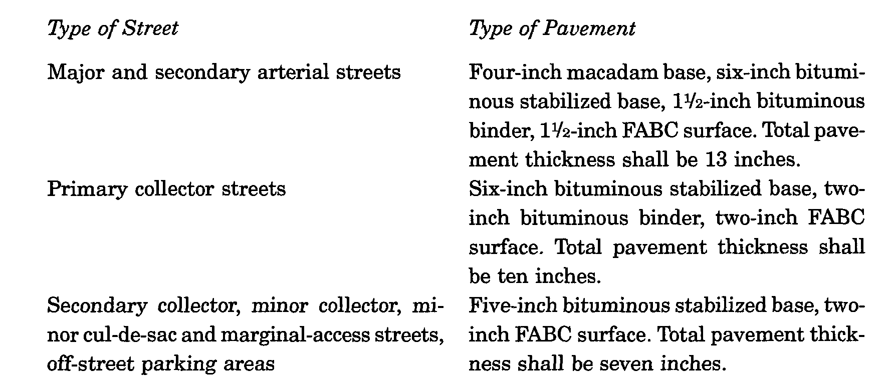
(1) Streets. All streets shall be constructed in accordance with the official grades adopted by the planning board and approved by the township council. Pavement specifications shall be as set forth in schedule I as follows:�
a. Bituminous pavement. Bituminous pavement shall be constructed in accordance with the state department of transportation standard specifications and supplements thereto on file in the office of the township engineer.�
b. Subgrade. Subgrade construction shall be done after all underground utilities have been installed and backfilled properly. Unstable places within the subgrade area shall be excavated and refilled with 1 1/2-inch quarry blendstone, as directed by the township engineer.�
c. Stabilized base course. The stabilized base course shall be machine spread to a minimum compacted thickness as set forth in schedule I in a method approved by the township engineer. The township engineer may require a prime coat to be applied to the subgrade.�
d. Bituminous surface course. The surface course shall be bituminous concrete FABC-1, laid to a minimum compacted thickness as set forth in schedule I. The township engineer may require a tack coat of asphaltic oil, applied at the rate of one-tenth gallon per square yard, to be applied to the stabilized base course before the bituminous surface course is laid. The bituminous surface course may not be laid until:�
1. The stabilized base has settled and all irregularities in it have been corrected.�
2. The stabilized base has been approved by the township engineer.�
e. Existing pavement. Whenever a new street meets existing pavement or an existing street is improved or continued, the edges of the existing pavement shall be cut at a 90-degree angle in a straight line and painted with a thin coat of asphaltic cement before any new course is laid.�
f. Trenches. All trenches or ditches which cross an existing street, which are dug for sewers, water mains, gas mains or other utilities, including house connections for these utilities, shall be filled with bank-run gravel. The gravel shall contain, by weight, from five percent to 25 percent of shale, slate, schist and soft or decomposed pebbles, and the quantity passing the no. 200 sieve shall not be less than four percent and not more than nine percent. The bank-run gravel, consisting of coarse sand with gravel from one-fourth to one-half inch in size, shall be placed in layers not exceeding 12 inches in depth and shall be flushed with water and/or mechanically compacted. All soft spots and depressions in a surface which has been graded will be removed and filled with stone of a size to be determined by the township engineer.�
g. Bordering streets. When existing streets bordering on or leading into the subdivision are deemed by the municipal agency to be incapable of properly carrying the increased traffic created by the subdivision or its anticipated future expansion, the subdivider may be required, at his expense, to improve and enlarge such streets.�
(2) Curbs and gutters. Curbs shall be installed on both sides of all streets, except as detailed in subsection (g)(20) of this section or unless specifically waived. Curbs shall be six inches wide at the top, at least eight inches wide at the bottom, shall have a six-inch face and shall be at least 18 inches high. Curbs shall be in sections not exceeding ten feet in length and, if concrete, shall have division plates extending entirely through the concrete. Granite or Belgium block curbs shall consist of stones ten to 14 inches in height set a minimum of four inches into a 12-inch concrete footing and backed with concrete to within four inches at the top, as per details on file at the township engineer's office. Premolded joint materials conforming to requirements recommended by the township engineer shall be used in curbs at intervals not in excess of 20 feet.�
(3) Sidewalks. Concrete sidewalks four feet in width and four inches thick, except at driveways where they shall be six inches thick, shall be installed on both sides of all streets, except as detailed in subsection (g)(20) of this section. The sidewalks shall be made of or cut into squares not exceeding five feet in length with division plates extending entirely through the concrete. Premolded joint material, as approved by the township engineer, shall be used at intervals not in excess of 20 feet and where curbs and sidewalks join each other. The sidewalk shall have a slope of one-fourth inch per foot toward the street and shall be placed two feet from the front property line. Concrete used in sidewalks shall be standard Portland cement conforming to American Society for Testing Materials Specifications Standard C 150-62, type B transit mix, and shall attain a net strength of 4,500 pounds per square inch in a period of 28 days.�
(4) Bicycle paths and bicycle racks. Bicycle paths shall be constructed using a stabilized base with a minimum of four-inch thickness over a subbase approved by the township engineer. They shall be six feet wide for one-way traffic and eight feet wide for two-way traffic. Bicycle racks or stands shall be provided outside all major public and commercial buildings.�
**Webmasters Note: The previous subsections, (g)(1) through (g)(4), have been amended as per Supplement No. 9�
(5) Bridle paths. Bridle paths shall be between ten feet and 12 feet in width. All hanging branches to a height of 12 feet over the path shall be removed. Where a wooden bridge over a stream is constructed, it shall be a minimum of eight feet in width. If cinders or gravel are required to be placed on the pathway, they shall be four to six inches deep, as required by the township engineer.�
(6) Street signs and other signs. Street signs shall be erected at all street intersections and shall conform in all respects to the standard detail sheet for such signs maintained by the township. The number and location of all street signs needed to regulate and control traffic or for warning purposes shall be determined by the municipal agency upon the recommendation of the director of public safety.�
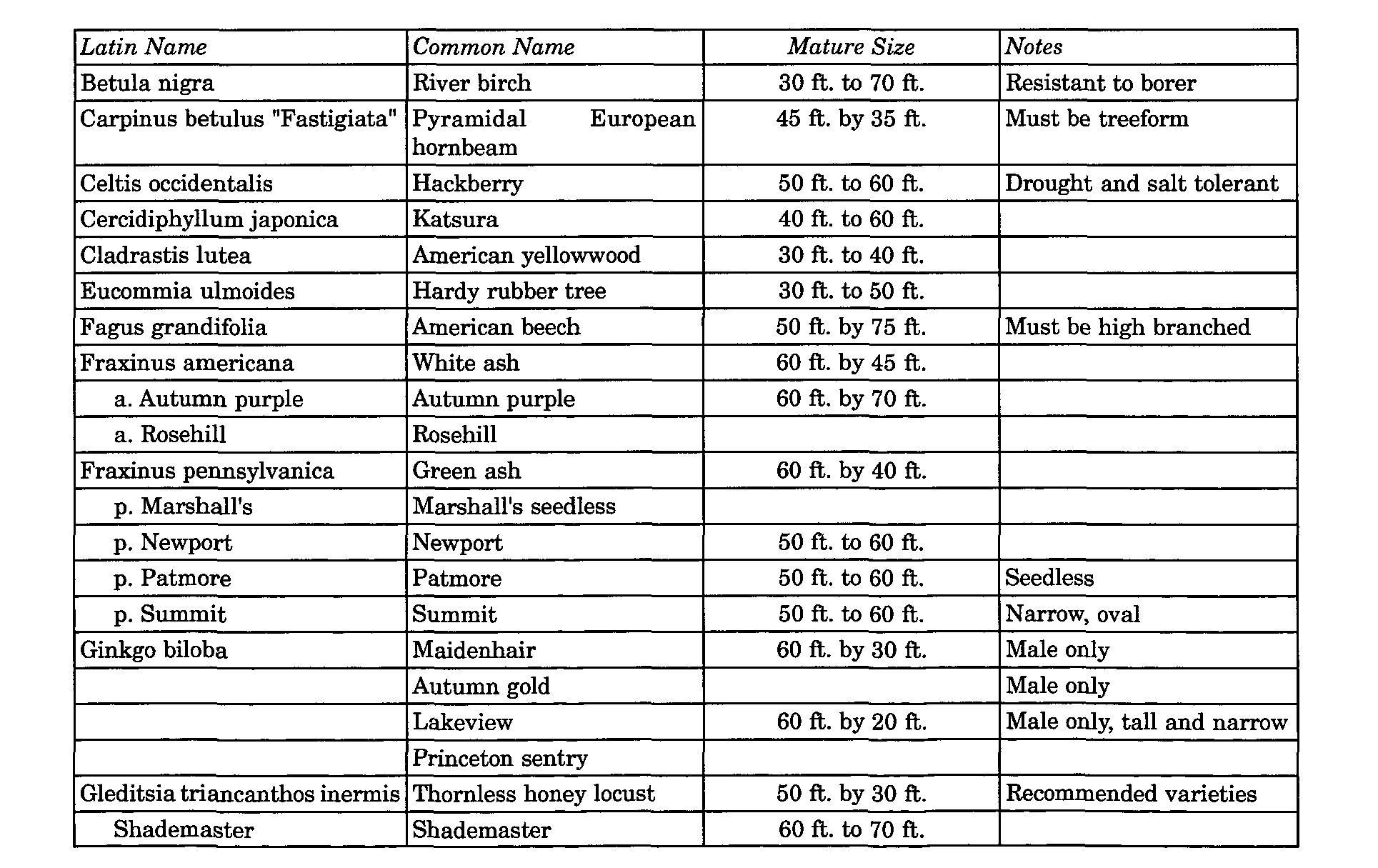
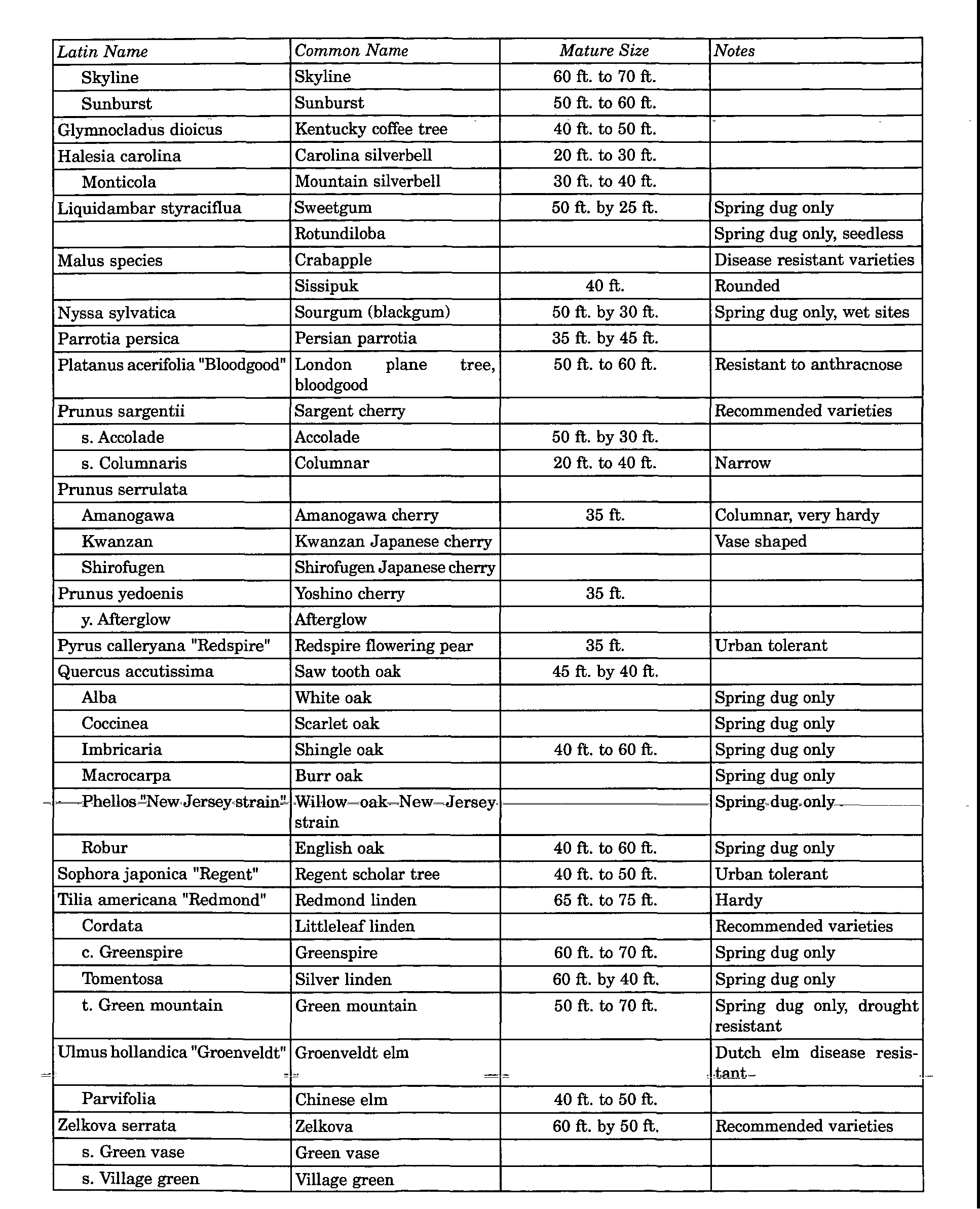
(7) Shade trees. Approved types of shade trees shall be planted between the street line and the setback line of each side of every street at intervals of no more than 50 feet. The following standards shall apply to the planting of shade trees:�
a. In developments where the distance from the house to the front sidewalk is 20 feet or less, type B trees shall be planted. In developments where the distance from the house to the front sidewalk is between 21 feet and 30 feet, the developer has the option of planting type A or type B trees. In developments where the distance from the house to the front sidewalk is 31 feet or more, type A trees shall be planted.�
1. Type A, mature size 30 feet and over (all trees to be high-branched treeform):�