[Added 4-10-2002 by Ord. No. 771-02; amended 4-9-2003 by Ord. No. 811-03]�
A. Purpose. The purposes of this section are the following.�
(1) Maintain the quality of streams, and improve the currently impaired streams in the Township.�
(2) Protect significant ecological components of stream corridors such as wetlands, floodplains, woodlands, steep slopes, and wildlife and plant habitats within the stream corridors of the Township, and minimize flood-related damage to properties in the Township.�
(3) Complement the existing state, regional, county and municipal stream corridor protection and management regulations and initiatives.�
B. Applicability. All tracts falling in whole or in part within a stream corridor shall be subject to the standards set forth in this § 165-76.�
C. Activities permitted in stream corridors. Stream corridors shall remain in their natural state, with no clearing or cutting of trees and brush (except for removal of dead vegetation and pruning for reasons of public safety), altering of watercourses, regrading or construction except for the following activities:�
(1) Wildlife sanctuaries, woodland preserves and arboretums, but excluding enclosed structures.�
(2) Fishing reserves, operated for the protection and propagation of wildlife, but excluding enclosed structures.�
(3) Unpaved walking, bicycling and bridle trails outside of the stream channel.�
(4) Fishing areas.�
(5) Reconstruction of a structure which predates the adoption of this section in the event of damage or destruction by fire, natural hazards, or other acts God, provided the reconstruction does not have a greater footprint or total area than that of the damaged structure and no change in land use occurs; and further provided that the reconstruction shall be permitted only if no more than 50% of the structure is destroyed, as determined by an impartial appraisal.�
(6) Agricultural land uses, including but not limited to cropland, pasture, nursery operations and greenhouses, in existence as of the effective date of this section. No new agricultural structures shall be permitted in the stream corridor after the effective date of this section.�
D. Locations of activities on tracts partially within stream corridors. All new lots in major and minor subdivisions and site plans created after the date of this section shall be designed to provide sufficient areas outside of stream corridors to accommodate primary structures as well as any normal accessory uses appurtenant thereto. The following activities associated with applications after the date of this section are permitted within the stream corridor if no other reasonable or prudent alternative is available:�
(1) Private or public water supply wells that have a sanitary seal, floodproofed water treatment facilities or pumping facilities.�
(2) Dredging or grading work incidental to permitted structures or uses, including stream cleaning and stream rehabilitation, work undertaken to improve hydraulics or to protect public health permitted and approved by the New Jersey Department of Environmental Protection (NJDEP).�
(3) Dams, culverts, bridges and roads provided that they cross the corridor as directly as practical.�
(4) Sanitary or storm sewers (excluding any related outfall facilities).�
(5) Utility transmission lines installed during periods of low stream flow in accordance with soil erosion and sediment control practices and approved by the Hunterdon County Soil Conservation District and permitted through the NJDEP.�
E. Prohibited activities. All activities not permitted pursuant to § 165-76C or D shall be prohibited. In no circumstances shall the following be permitted as exceptions to such subsections:�
(1) Any solid or hazardous waste facilities, including but not limited to sanitary landfills, transfer stations or wastewater lagoons.�
(2) Junkyards, commercial and industrial storage facilities and open storage of vehicles or materials.�
F. Provisions governing activities in stream corridors. The applicant for any activity permitted in a stream corridor shall rehabilitate any degraded areas within the stream corridor in a manner acceptable to the Planning Board unless the applicant demonstrates that it is economically infeasible to do so. The applicant shall also:�
�
(1) Rehabilitate or cure the affects of disturbance caused during construction through the use of best management practices (BMPs) recommended by the NJDEP;�
(2) Maintain the integrity of the surrounding habitat; and�
(3) Maintain the existing ability of the stream corridor to buffer the stream. The applicant shall provide whatever additional measures are necessary to assure that areas designated as stream corridors will be rehabilitated or preserved and to prevent additional encroachments in a stream corridor likely to occur as a result of the approval granted. The Planning Board requires conservation easements and/or deed restrictions assuring that there will be no further intrusion on the stream corridor than that permitted by the activity approved.�
G. Submission requirements. An applicant for an activity in a stream corridor shall submit to the municipality a map of the project site delineating the following (at a scale of one inch equals 200 feet), using the best available information:�
(1) One-hundred-year delineated flood line.�
(2) Wetland boundary lines.�
(3) The stream corridor boundary.�
(4) Any slopes equal to or greater than 15% within the site.�
(5) The location of all improvements and land disturbance proposed to be located within any of the above boundaries.�
(6) A stream corridor restoration plan that specifies best management practices and construction methods to be used to restore all land disturbed within the stream corridor.�
[Added 6-13-2007 by Ord. No. 923-07]�
Applicability. All applications for major subdivisions, major site plans and variance applications shall comply with these provisions.�
A. Purpose:�
(1) To protect existing woodland and encourage reforestation of nonagricultural land.�
(2) To prevent soil erosion and soil depletion and increase water retention and water quality.�
(3) To improve the appearance of off-street parking and vehicular use areas near public rights-of-way or adjoining uses.�
(4) To protect agricultural land use and historic areas from the impact of new development.�
(5) To screen residential and commercial subdivisions and development from public view.�
(6) To promote public health, welfare and safety by reducing noise and air pollution, visual pollution, air temperature and light glare.�
B. Conceptual landscape design considerations. The site and surroundings should be thoroughly analyzed. The following items shall be reviewed to determine the design layout and/or plant material selection:�
(1) The shape and/or form of the land itself and its relationship to the existing and proposed buildings. Plantings shall give scale to the buildings and other site elements.�
(2) The geology and soil characteristics.�
(3) The surface and subsurface water conditions.�
(4) Existing vegetation patterns. (Except in urban and other highly disturbed sites, the native vegetation found on and around the site is usually a good indicator of which vegetation types will perform well.)�
(5) Solar orientation and exposure, accounting for land forms, existing vegetation and neighboring structures.�
(6) Local and regional climate (precipitation, temperature ranges, humidity, wind patterns, etc.).�
(7) Air, noise and water pollution.�
(8) Community, social, historical and cultural values.�
(9) Plantings adjacent to fire suppression access and utilities shall be done so as not to obstruct or hinder their operations in the event of an emergency.�
(10) Plantings shall also create human scale and space. Consider pedestrian safety and state of mind by providing appropriate lighting at pathways.�
(11) The approving authority may require items of construction such as retaining walls,guardrails, safety fencing, traffic barricades or other devices necessary in the interest of public safety and convenience.�
C. Landscape design plan submission requirements:�
(1) Plan prepared and signed by a certified landscape architect.�
�
(2) Name, address and telephone number of the owner and developer.�
(3) Name, address, telephone number and qualifications of the professional who prepared the plan.�
(4) A legal description or boundary line survey of the site on which the work is to be performed.�
(5) A plan of the site at a scale of no less than one inch equals 40 feet that shows:�
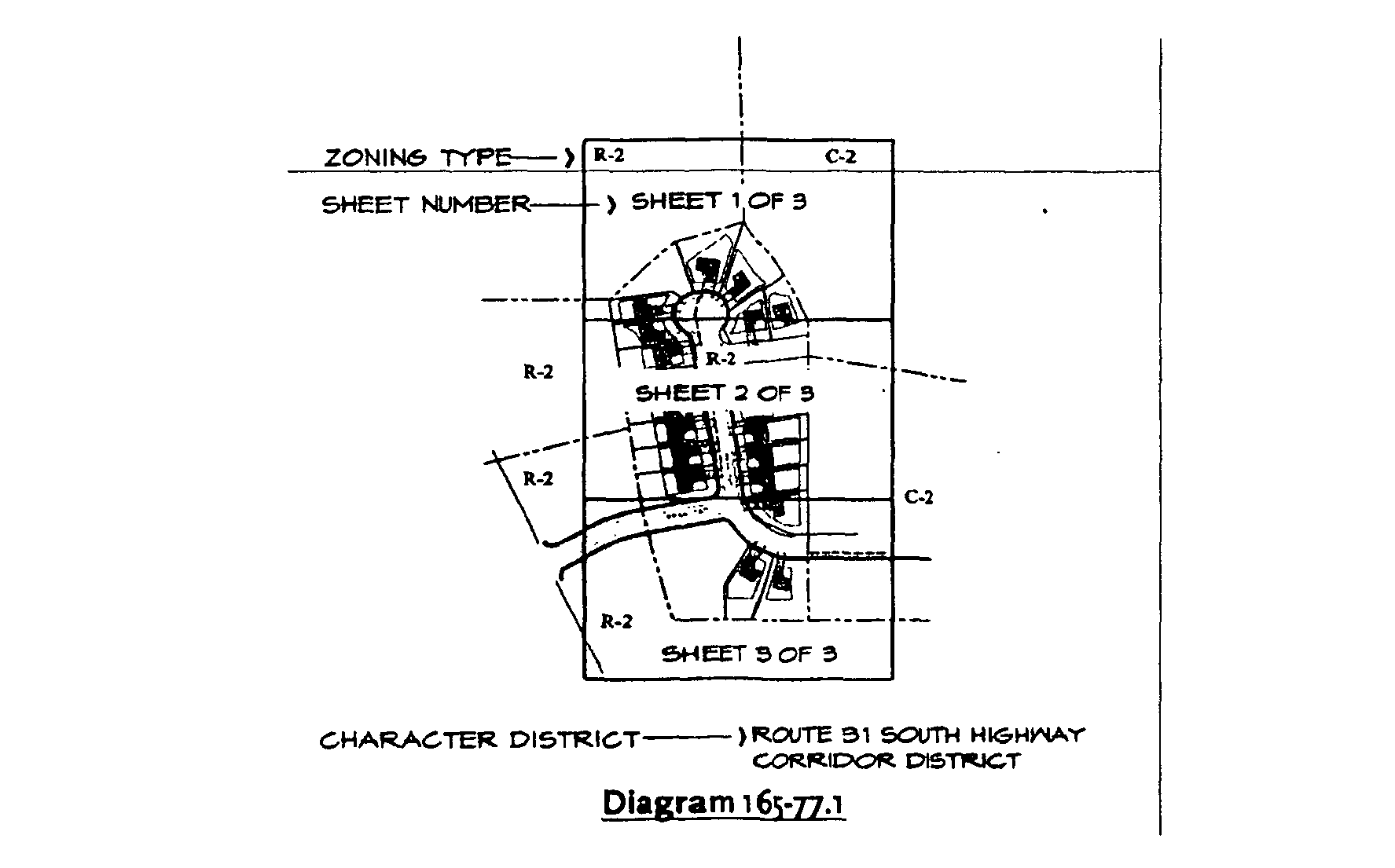
(a) Where necessary, a key map at a larger scale to show the entirety of the site. In the event that more than one sheet is needed to show the site, the subsequent sheets shall be identified on a key map as shown below:�
(b) Existing and proposed topography at a maximum of two-foot contour intervals, except where the slopes equal or exceed 12% grade where five-foot contour lines shall be shown, extending at least 100 feet beyond the site boundary.�
(c) Delineation of all forest areas.�
(d) Delineation of the limit of disturbance.�
(e) All six-inch DBH and larger trees within the limit of disturbance and 50 feet beyond the limit of disturbance.�
(f) Indication of whether all six-inch diameter at breast height (DBH) and larger trees within the limit of disturbance and 50 feet beyond the limit of disturbance are proposed to be removed, preserved and/or transplanted. For each case, the size, species and health condition of each tree shall be noted.�
(g) Identification of tree masses and understory groupings in areas outside of the 50 feet beyond the limit of disturbance.�
(h) Identification of all existing features occurring on the site. Such features include, but are not limited to, rock outcroppings, boulders, stone rows, hedgerows, meadows and vistas.�
(i) The location of all existing and proposed buildings and structures.�
(j) The location of all existing and proposed easements.�
(k) The location of all existing and proposed parking spaces and vehicular use areas.�
(l) The location of all existing and proposed public rights-of-way.�
�
(m) The location of all existing and proposed overhead and underground utilities.�
(n) The location of all existing and proposed stormwater management cornponents.�
(o) The location of all existing and proposed standpipes.�
(p) The location of all existing and proposed hydrants and fire suppression tanks.�
(q) Plant location and labels indicating species type and quantity of species labeled for each plant or group of plants.�
(r) Zoning districts of the proposed site and adjacent properties.�
(s) North arrow respective to the direction of north on the site.�
(6) A planting listing for all proposed landscape materials showing caliper sizes, height of material, method of installation, botanical and common names, type and arnount of mulch, ground cover, grasses and root type (bare root or balled and burlapped), and quantity of materials.�
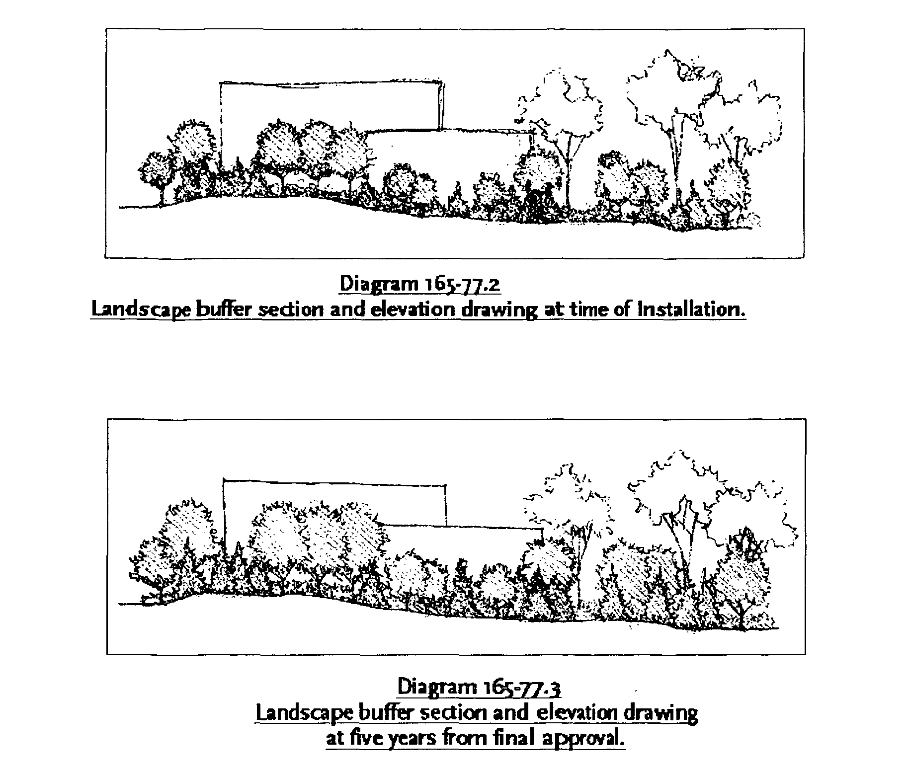
(7) A landscape elevation drawing, drawn to scale, showing the height and density of proposed buffers, as required to accurately depict the proposed plan, including structures and existing plant material to remain. One elevation drawing representing the relationship with the building and the proposed buffer at installation and one at five years after installation for each buffer shall be required. See Diagrams 165-77.2 and 165-77.3 below.�
(8) All areas of planting beds to receive mulch shall specify the depth and type of mulch.�
(9) Planting details, typical for evergreen trees, deciduous trees and shrubs.�
(10) The proposed planting dates.�
(11) A statement of intent' to install and maintain all such landscaped areas in accordance with the requirements of this chapter.�
(12) An accompanying itemized cost estimate covering all new plantings and mulch contained on the planting plan and installation of said material together with a surety bond acceptable to the Township in an amount sufficient to insure completion within the time specified and in accordance with the landscape plan and to guarantee the healthy growth of the plant material for two years past the date of completion of the development.�
(13) A soil composition analysis and ph test.�
(14) Completion of Chart 165-77.1, below, indicating compliance with buffer requirements, per § 165-77 of the Clinton Township Land Use Regulations.�

D. Preservation of existing individual trees.�
(1) All applications for development shall include a plan to preserve all existing trees that are in good health and an asset to the Township as determined by the approving authority and/or designated representative.�
(2) Desirable, healthy plants that are an obstacle to the design of the development of the property shall be transplanted or replaced elsewhere on the property with healthy plants at the discretion of the Municipal Landscape Architect. All efforts shall be made in developing a site to preserve desirable trees. The Municipal Landscape Architect may recommend adjustments to the site development rather than risk the health of the existing trees due to site disturbance.�
(3) All trees to be preserved within the limit of disturbance shall have tree protection in accordance with the Clinton Township Soil Erosion and Sediment Control Ordinance.�
(4) Trees with a six-inch or greater diameter at breast height (DBH) shall be saved whenever possible and shall be protected from damage to roots, trunk and branches. The Township Landscape Architect, or other designated representative, shall designate those trees which are to be saved. Soil should not be added on top of the existing root zone(s). Tree wells are to be provided where necessary and trees to remain within the improvement project limits are to be trimmed as directed by the Township Landscape Architect, or other designated representative.�
(5) Large trees (greater than six-inch DBH) shall be replaced by a tree of similar caliper or may be replaced with multiple smaller-caliper trees at a 2:1 ratio (two caliper inches of new trees shall be provided for every one inch DBH removed). No tree planted as a replacement shall be less than two inches caliper. For example, a tree measuring 16 inches in diameter at breast height (DBH) may be replaced with 16 two-inch caliper trees.�
(6) Trenching for utilities shall be done in such a manner as to avoid disturbance within 20 feet of the trunk of the tree. Air spading and other approved methods may be acceptable alternatives to realigning proposed utilities.�
(7) Replacement trees shall be in addition to the count required to meet the buffering as set forth elsewhere in this section.�
(8) The following shall be exempted from the prohibitions of this subsection:�
(a) Trees located on a tract of land having a total area of less than one acre with a building located thereon;�
(b) Any trees cut or removed in accordance with an approved management plan of a proper state or federal authority;�
(c) Any trees located on publicly owned lands;�
(d) Any trees required to be cut in connection with the installation of public utilities once all other options have been investigated;�
(e) Trees endangering public health and safety; and�
(f) Trees located in commercial orchards or nurseries.�
E. Preservation and reforestation of existing forested areas.�
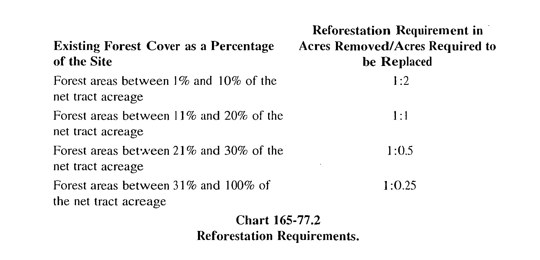
(1) Every effort should be made to preserve existing forest areas, including the overstory and understory vegetation within the forested areas. After every effort has been made through creative site planning techniques and sensitive grading and drainage design, and the approving authority agrees that it is necessary for clearing of forests to occur to accommodate site development, reforestation with native tree species shall be required according to Chart 165-77.2.�
Chart 165-77.2 Reforestation Requirements.�
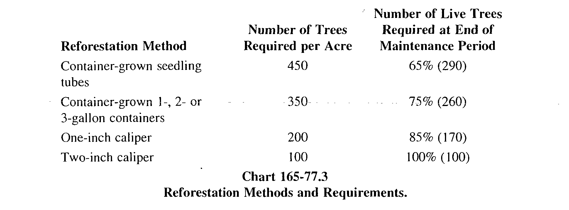
(2) The method of reforestation shall be determined by individual site conditions and shall be approved by the approving authority. The planting may be comprised of a mix of tree sizes, with stocking rates determined as a percentage of each planting size proposed. Stocking rates for reforestation plantings shall be in accordance with Chart 165-77.3.�
Chart 165-77.3 Reforestation Methods and Requirements.�
(3) Reforestation plantings shall include at least 30 shrubs per acre.�
(4) Reforestation plans shall contain specifications for treatment of the ground plane with either two inches of wood chips or a native ground cover, a maintenance plan including the periodic removal of exotic/invasive plants, and deer protection measures.�
(5) All reforestation plantings shall be maintained for a period of two years.�
(6) All reforestation plantings shall be placed in a permanent conservation easement.�
F. Official list of plants.�
(1) The following list of plants is provided to guide species selection. Species selection should be based on an appropriate woodland successional model, and shall include species that are native to the region and noninvasive, as deemed by the Municipal Landscape Architect.�
(a) Canopy trees:�
[1] Red oak (Quercus rubra).�
[2] White Oak (Quercus alba).�
[3] Black oak (Quercus velutina).�
[4] Chestnut oak (Quercus prinus).�
[5] Pin oak (Quercus palustris).�
[6] Red maple (Acer rubrum).�
[7] Sugar maple (Acer saccharum).�
[8] Green ash (Fraxinus pennsylvanica).�
[9] White ash (Fraxinus americana).�
[10] American beech (Fagus grandifolia).�
[11] Tulip tree (Liriodendron tulipifera).�
[12] Sweet birch (Betula lenta).�
[13] River birch (Betula nigra).�
[14] Paper birch (Betula papyrifera).�
[15] Sweetgum (Liguidambar styraciflua)*.�
[16] Sycamore (Platanus occidentalis)*.�
[17] Black gum or sour gum (Nyssa sylvatica).�
[18] Basswood (Tilia americana).�
Note: *Locate tree trunk not closer than 40 feet to roadways, parking lots, pedestrian walkways, and bicycle paths.�
(b) Ornamental/Understory trees:�
[1] Common witchhazel (Hamamel is virgimana).�
[2] Flowering dogwood (Comus florida).�
[3] Shadtree (Amelanchier canadensis).�
[4] Sassafras (Sassafras albidum).�
[5] Sweetbay magnolia (Magnolia virginiana).�
[6] Hop horn beam (Ostrya virginiana).�
[7] Ironwood (Carpinus carolinian).�
[8] Red cedar (Jumperus virginiana) EG.�
[9] American Holly (Ilex opaca) EG.�
[10] White pine (Pinus strobus) EG.�
[11] Red pine (Pinus resinosa) EG.�
Note: EG = evergreen.�
(c) Shrubs:�
[1] Summersweet (Cletha alnifolia).�
[2] Gray dogwood (Corpus paniculala).�
[3] Silky dogwood (Corpus amomum).�
[4] Inkberry (Ilex glabra) EG.�
[5] Spicebush (Lindera benzoin).�
[6] Highbush blueberry (Vaccinum coryinbosum).�
[7] Arrowwood viburnum (Viburnum dentatum).�
[8] Maple-leaved viburnum (Viburnum acerifolium).�
[9] Blackhaw viburnum (Viburnum prunifolium).�
[10] Mountain laurel (Kalmia latifolia) EG.�
[11] Rosebay rhododendron (Rhododendron maximum) EG.�
Note: EG = evergreen.�
G. Parking lot landscape design.�
(1) In every effort to minimize the visual impacts of large parking lot areas, the applicant shall install a parking lot buffer. Such buffer shall screen parking from the public right-of-way and adjacent uses both on- and off-site.�
(a) The buffer shall consist of canopy trees, ornamental/understory trees, evergreen trees, shrubs and perennials within a ten-foot minimum width consistent with the parking perimeter.�
(b) Where parking is located in a front yard, the approving authority may require construction of landscaped berms up to a height of five feet, with slopes at a ratio of not less than 3:1.�
(c) Where off-street parking and loading areas adjoin or face premises situated in a residential zone, the approving authority may require the construction of a fence or stone wall not less than three feet nor more than six feet in height, maintained in good condition. Additionally, the approving authority may require construction of planted berms up to a height of five feet, with slopes at a ratio of not less than 3:1.�
(d) Said buffer shall screen 60% of the automobile/parking lot from the road and pedestrian view during the time frame of November to April within two years of installation.�
(e) Woody shrubs shall be set back from the curb three feet for vehicular overhang and snow removal.�
(f) Plantings shall not obstruct visibility necessary for automobile and pedestrian circulation and safety within the facility.�
(g) All plant material shall be subject to review by the approving authority and Municipal Landscape Architect.�
(2) Large expanses of pavement and long, unbroken rows of parking spaces shall be avoided. No row of parking spaces shall contain more than 15 spaces unless broken by landscaped islands.�
(a) Landscape islands shall be a minimum width of 10 feet and a minimum depth of 18 feet.�
(b) At a minimum, landscape islands shall contain one canopy tree.�
(c) Adjoining rows of parking shall be separated by landscape islands having a width of at least 10 feet.�
(3) Ten percent of all surface parking areas and the top story of raised parking decks where no roof is provided shall be landscaped. The parking area shall be determined by the outer Iii-nut of pavement on the site and the inner limit of pavement around or adjacent to the building.�
(a) Canopy trees are required to reduce heat island effect. At a minimum, one canopy tree for every three parking spaces for on-grade parking shall be planted at the perimeter or within said parking area.�
(4) Trash collection areas. Trash collection areas shall be enclosed by a masonry wall with a minimum height of six feet.�
(a) Masonry walls shall consist of the same or complementary building materials as those used for the principal use on the site.�
(b) Access to the trash collection areas shall be provided by an opaque gate with a minimum height of six feet.�
[1] Gate materials shall be visually consistent with the appearance of the masonry walls enclosing the trash collection area and the principal use on the site.�
(5) Loading zones. All loading zones shall contain a buffer consisting of 60% evergreen plant material.�
(a) Said buffer shall screen 60% of all loading areas from the road and pedestrian view during the time frame of November to April within two years of installation.�
H. Street and highway landscape design.�
(1) Street trees shall be required on all public and private roads in Clinton Township.�
(2) Species and tree placement shall be specific to the site design concept and site conditions and subject to approval by the approving authority.�
(3) The use of multiple species is required. Tree species shall alternate along the road to create a sequence through the space.�
(4) A specific standard design module for street and highway plantings will not be put forth here since each site (and its surroundings) has a unique character. A downtown street tree planting may only require a single species of canopy tree equally spaced in a geometric pattern. With the landscape forms most often found in Clinton Township, the use of a single species of trees in geometric patterns becomes less appropriate. The linear, less formal hedgerow seen commonly bounding cropland, fields, and pastures is often a more suitable model for plantings along lot lines and streets and highways traversing such landscapes.�
(5) All street trees in a formal street tree planting shall be located within the street right-of-way and in such a manner as not to interfere with sidewalks and/or utilities, with the exception of those areas where the landscape design standards for nonresidential development in § 165-75 dictate otherwise.�
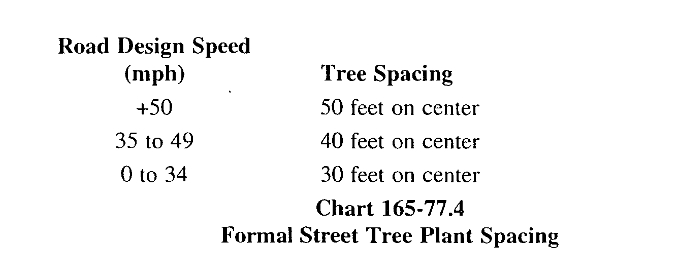
(6) Within formal street tree plantings, tree spacing shall correlate with road hierarchy and, in general, spacing shall range from a minimum of 30 feet on center to a maximum to 50 feet on center. At slower design speeds and at areas of special interest like town centers, the spacing shall be closer together (i.e., 30 feet on center). See Chart 165-77.4 for additional information.�
(7) Specific guidelines are required within each district. See "Preserving Community Character, Community Design Guidelines for Clinton Township."�