
A. When required. An EIS is required as part of any application for development involving new buildings or any land disturbance where Planning Board approval is required. Additionally, any proposal for development within the Critical Geologic Formation Zone as shown on the official map of the Township requires an analysis in accordance with the geologic segment of the EIS. The Planning Board may grant an exemption from the requirement of part or all of an EIS under Subsection G below. An EIS is also required for all public and quasi-public projects unless they are exempt from the requirements of local law or by supervening county, state or federal law. [Amended 5-9-1988 by Ord. No. 367-88]�
B. Filing requirements. An application for development shall be accompanied by 12 copies of an EIS unless waiver is desired, in which case the application shall be accompanied by a request for waiver pursuant to Subsection G.�
C. Contents of EIS. The EIS shall discuss and analyze those factors required for the particular project as provided in Subsection D and any other factors pertinent to the project. Where the information is provided elsewhere in the application, it may be incorporated by reference. The applicant may request a preapplication conference with the Planning Board to discuss the scope and detail of the EIS, and the Planning Board may seek the advice of the , Environmental Commission in determining said scope and detail. The EIS shall address each of the items outlined below to the degree and extent it is pertinent to the project. In preparing the EIS, the applicant may utilize resource information available from the Township.�
(1) Plan and description of proposed project: a project description, complete with site plans, which shall specify the purpose of the proposed project, including products and services, if any, being provided, and the regional, municipal and neighborhood setting, including current land use of the project site and properties within 500 feet of the site.�
(2) Inventory of existing natural resources: Generally, an inventory will consider the air quality, topography, surface water bodies, surface water quality, aquatic biota, soils, geology, groundwater, vegetation, wildlife, archaeological and historical features. Forest vegetation is to be classified by type and age class. The distribution of types and classes will be indicated on a map, the scale of which will be one inch equals 100 feet or such other scale as may be required. The location, species and diameter at 4 1/2 feet above the ground of all isolated trees four inches, or dogwoods three inches, or more in diameter are to be shown on the same or on a separate map.�
(3) Assessment of environmental impact of project: an assessment supported by environmental data of the environmental impact of the project upon the factors described in Subsection C(2) above, and specifically the following:�
(a) Wastewater management:�
[1] An estimate of the expected quantity and type of wastewater expected from the proposed development. If any flow is expected, discuss:�
[a] If disposal is on site, the relation to topography, soils and underlying geology, including water table, aquifer recharge areas and all wells within 500 feet of the disposal area; include results of percolation tests and soil logs required by ordinance.�
[b] If disposal is to an existing private facility or to a public facility, identification, owner and location of the plant and location of the existing collection point to which the proposed project would be connected. Documentary evidence that the expected flows from the proposed facility will be accepted and can be treated adequately by the private or public facility must accompany the environmental impact statement.�
[2] Compliance with all applicable state and Township health regulations.�
(b) Water supply:�
[1] If the water is to be supplied from the site and a flow of 100,000 gallons per day or less is required, an impact assessment of water supply is required if the anticipated demand exceeds the available safe yield of the aquifer contained within the property limits indicated in the resource inventory maintained by the Environmental Commission. In such case the applicant must substantiate and explain the anticipated demand, present proof that the aquifer contained within the property limits can yield the desired amount of water, demonstrate that wells proposed for installation will meet acceptable standards and assess the effect of proposed withdrawals on existing and proposed wells and surface water bodies within the geologic formation. If the plan includes 50 or more dwelling units, certification of the adequacy of the proposed water supply and sewerage facilities must be obtained from the New Jersey Department of Environmental Protection and must be included in the EIS.�
[2] If the water is to be supplied from the site and the total project demand for water supply is in excess of 100,000 gallons per day, the applicant must obtain a diversion permit from the New Jersey Department of Environmental Protection. The applicant must assess the effect of proposed withdrawals on existing and proposed wells and surface water bodies within the geological formation. The applicant will supply copies of all resources information provided to the appropriate state water agency in support of his application for diversion grant. In addition, if the anticipated demand exceeds the available safe yield, the applicant must explain the anticipated demand and demonstrate to the satisfaction of the Planning Board that the aquifer contained within the property limits can yield the desired amount of water.�
�
[3] If the water is to be supplied from any existing private or public facility, the identification, owner and location of the facility and the location of existing distribution point to which the proposed project would be connected shall be provided. The applicant will submit documentary proof that the facility has the available excess capacity in terms of its allowable diversion and equipment to supply the proposed project and is willing to do so. The applicant must demonstrate to the satisfaction of the Planning Board that the total consumption of groundwater from on-site and off-site sources will not exceed the available safe yield of the aquifer contained within the property limits.�
[4] Subsection C(3)(b)[1], [2] and [3] notwithstanding, for parcels of less than five acres before subdivision and for residential uses, the Planning Board may weigh all factors affecting water supply and water need in deciding whether or not to require strict adherence to the requirement that demand not exceed safe sustainable yield from the aquifer within the property limits.�
(c) Surface drainage: discussion of the surface water management plan to be submitted in accordance with Article XXXV, Surface Water Management, Ï 165-232, and compliance with the provisions of that chapter.�
(d) Stream corridors: a description of any streams and immediate environs, steep banks, springs and wetlands and streamside vegetation located on the property, including a map depicting the floodway and flood hazard area as reflected on flood hazard area delineation maps on file with the Township, along with evidence of compliance with Chapter XV. The applicant shall supply copies of all resource information provided to the Division of Water Resource in support of his application for any required encroachment permit.�
(e) Solid waste disposal: estimate the volume of solid wastes, by type, including excess earth, expected to be generated from the proposed project during construction and operation and describe plans for collection, storage, transportation and disposal of these materials; identify the location(s), type(s) and owner(s) of the facility (facilities) which will receive such solid wastes; if the facility is a landfill, submit proof that it is registered with the Division of Environmental Quality, New Jersey Department of Environmental Protection, and is operated in compliance with the New Jersey Sanitary Code.�
(f) Air quality: describe each source, its location, the quantity and nature of materials to be emitted from any furnace or other device in which coal, fuel oil, gasoline, diesel fuel, kerosene, wood or other combustible material will be burned, or if any other source of air pollutants, including automobiles attracted by the facility, will be present on the site during or after construction. Evidence of compliance with any applicable-state-and -federal---regulations shall accompany the EIS. If a state or federal emission permit is required, a copy of all resource data submitted with the application for the permit shall also accompany the EIS.�
(g) Noise: a statement of anticipated effects on noise and vibration levels, magnitude and characteristics related to on-site activities and proposed method(s) of control. Background levels of noise throughout the anticipated area affected must be determined. Any applicant for industrial and commercial enterprises must show that after construction and during normal operation the enterprise will not exceed the State of New Jersey regulations controlling industries and commercial stationary sources (N.J.A.C. 7:29-1.1 et seq.).�
(h) Traffic: determine the present traffic volume and capacity of the road(s) serving the project and the nearest major intersection and set forth projected volumes for the same upon completion of the project.�
(i) Social economic: an analysis of the factors affecting the finances of the Township, which shall include the estimated changes in tax receipts and fiscal outlay for municipal services; estimated number and types of jobs to be provided; calculation of the number of school-age children to be produced; and any addition to existing municipal services rendered by the project:�
(j) Aesthetics: discuss how the natural or present character of areas will be changed as a result of the proposed action.�
(k) Artificial light: a statement of anticipated effects on light, magnitude and characteristics related to on-site activities and proposed method(s) of control, with particular attention to the control of sky glow.�
(l) Critical areas: a statement of the impact on critical areas, including stream corridors, wetlands, slopes greater than 12%, highly erodible soils, areas of high water table, mature stands of native vegetation, aquifer recharge and discharge areas and other environmentally sensitive features, areas or conditions not addressed elsewhere in the EIS. If wetlands exist or whenever one or more indicators of wetlands are present, the EIS shall include a letter of interpretation from the Freshwater Wetlands Section, Division of Coastal Resources, New Jersey Department of Environmental Protection. [Amended 11-28-1988 by Ord. No. 386-88]�
(m) Energy conservation: a description of the site in terms of its physical orientation to solar access and prevailing winds, addressing the building and site design and arrangement in terms of energy efficient principles and maximum utilization of renewable energy sources following criteria established in Ï 165-70H or 165-71E, as the case may be.�
(n) Geologic conditions report: for all tracts located in the Critical Geologic Formation Zone, the EIS shall contain data obtained during an appropriate site investigation. A comprehensive site investigation program shall be conducted by the applicant to provide the Planning Board with sufficient data to define the nature of all existing geologic conditions that may limit construction and land use activities on the site. Specifically, the investigations shall yield information which shall demonstrate that the proposed development will identify any existing geologic conditions for which appropriate engineering solutions may be necessary to minimize any adverse environmental impact caused by the proposal. [Added 5-9-1988 by Ord. No. 367-88]�
(4) Environmental protective measures. The EIS shall contain a listing of all environmental protective measures which will be used should the proposed project be implemented. These are measures which will avoid or minimize adverse effects on the natural and man-made environment of the site and region during the construction and operation of the facility.�
(5) Adverse impacts which cannot be avoided. The EIS shall contain a summary fist, without discussion, of the potential adverse environmental impacts which cannot be avoided should the proposed project be implemented. Short-term impacts should be distinguished from irreversible impacts. Any impacts on critical areas, which include but are not limited to streams, floodways, wetlands, slopes of 12% or greater, highly acid or highly erodible soils, areas of high water table, aquifer recharge areas and mature stands of native vegetation, should specify the type of criteria involved and the extent of similar areas which will not be affected.�
(6) Summary environmental assessment. The EIS shall contain a concise summary of the environmental impact assessment for the proposed project. This summary will evaluate the adverse and positive environmental effect of the project should it be implemented and the public benefits expected to derive from the project, if any.�
(7) Critical geologic formation area investigation program. [Added 5-9-1988 by Ord. No. 367-88; amended 12-12-2002 by Ord. No. 799-02]�
(a) A Critical Geologic Formation Area Investigation Program shall be performed in accordance with this section for all properties located within the Critical Geologic Formation Area (CGFA) or the Critical Formation Watershed Protection Area (CFWPA). The investigation program shall commence by completing the Critical Geologic Formation Investigation (CGFI) Checklist L" The applicant shall submit three copies of the completed (CGFI) Checklist I to the Planning Board Secretary along with the application fee and review escrow defined in Ï 165-13F of this chapter. The Planning Board Secretary shall forward the CGFI Checklist I to the Township Geotechnical Consultant (GTC) for review. The GTC shall recommend to the Planning Board and applicant that CGFI Checklist II be prepared and submitted, or in the alternative, that portions or all of the requirements required by CGFI Checklist II be waived within 30 days of submission of CGFI Checklist 1. If CGFI Checklist 11 is required by the Planning Board, per GTC recommendation, the applicant shall then prepare and submit a completed CGFI Checklist II to the Planning Board Secretary. CGFI Checklist II shall be reviewed by the GTC, and a report shall be made to the Planning Board and the applicant advising whether the checklists are complete within 45 days of the date of submission of CGFI Checklist II The report shall also advise the applicant as to whether any proposed testing methodology is prohibited because of the potential danger the methodology may pose to the integrity of the site or the health, safety and welfare of the community. The geotechnical consultant may also recommend waiver of some or all of the required investigations in appropriate cases pursuant to Subsection G. At the applicant's option, both CGFI Checklist I and CGFI Checklist II may be submitted simultaneously.�
(b) After CGFI Checklists I and II have been deemed complete by the Planning Board, via GTC recommendation, and the GTC has advised the Planning Board that the testing methodology poses no danger to the integrity of the site or the health, safety and welfare of the community, the GTC shall grant approval for the applicant to commence the testing procedure.�
[1] Any on-site investigations and tests shall not begin until the applicant has received approval of the investigative plan and approval to commence testing has been issued. Additionally, actual notification at least 15 days in advance of the testing to commence, in writing, by certified mail, return receipt requested, or by personal service of said notice on the Township Clerk and the GTC, shall be given.�
[2] The applicant shall arrange to have the proposed development site open for on-site inspection by the GTC or designated Township inspectors at all times while the field investigation program is in progress, and testing data and results shall be made available to Township officials and Township inspectors on demand, but at no less frequent intervals than bimonthly.�
[3] At the completion of the field investigation, a Geotechnical Site Investigation Report, shall be submitted. This report shall contain logs of all borings, test pits and probes, including evidence of incipient cavity formations, loss of circulation during drilling, voids encountered and similar cavities, type of drilling or excavation technique employed, drawings of monitoring or observation wells as installed, times and dates of explorations and tests, reports of chemical analyses or on-site surface and ground water, names of individuals conducting tests if other than the P.E. referred to in the checklist, analytical methods used on soils, water samples and rock samples, a one-inch-to-one-hundred-feet scale topographic map of the site (at a contour interval of two feet) locating all test pits, borings, wells, seismic or electromagnetic, conductivity or other geographical surveys, an analysis of the ground water regime with rate and direction of flow, a geologic interpretation of the observed subsurface conditions, including soil and rock type, jointing (size and spacing), faulting, voids, fracturing, grain size and sinkhole formation.�
[4] The Geotechnical Site Investigation Report shall define the extent of geotechnical concerns at the site in relation to the planned development or land use. The proposed engineering solutions to minimize environmental impact as a result of the project, both during construction and in the foreseeable future, must be clearly detailed, together with the basis for the conclusions reached.�
[5] All samples taken shall be preserved and shall be available for examination by the Township upon request until a resolution of approval is granted by the Planning Board on any site plan or subdivision application for the property.�
(8) Aquifer test and analysis. [Added 8-14-2002 by Ord. No. 788-02]�
(a) Intent. It is the intent of the requirements of this Article that an Aquifer Test and Analysis as set forth in Ï 165-72C(8)(e)[1] be provided as part of a preliminary plat application of a major subdivision of three new building lots or more which subdivision is to be served by on-site wells. It is the intent that an aquifer test and analysis as set forth in Ï 165-72C(8)(e)[2] be conducted for major subdivision of two new building lots or less and minor site plans. It is the intent that an aquifer test and analysis as set forth in Ï 165-72C(8)(e)[3] be conducted as part of a submission of a nonresidential or residential preliminary site plan when the development proposed by such site plan is to be served by one or more on-site wells.�
(b) Applicability. The deepening or replacement of a well that has the primary purpose of providing drinking water to a residence is exempt from the requirements of this subsection. However, the installation of a second well with the primary purpose of irrigation, filling of swimming pools, or any other purpose other than to serve as the sole source of drinking water for a residence must satisfy the requirements of Ï 165-72C(8)(d) and C(8)e[l]. A well installed for irrigation, filling of swimming pools, or any purpose other than providing the sole source of drinking water is considered to serve a nonresidential use.�
(c) Waiver. If an applicant can show that given the expected average daily demand and distance to other nearby wells, the proposed development will not induce drawdown in any existing or future wells adjacent to the boundaries of the proposed development or any existing or future wells within the proposed development, then the applicant can request a waiver from the Planning Board or Board of Adjustment, as the case may be (the "Board"), for all or some of the requirements of this subsection.�
(d) Aquifer test and analysis.�
[1] The testing procedures for a major subdivision or site plan shall be based on a hydrogeologic analysis and a minimum of one aquifer test. The hydrogeologic analysis shall include the review of available information including but not limited to published maps and reports depicting Clinton Township and surrounding municipalities, stereo pairs of aerial photographs, and New Jersey Geological Survey (NJGS) Special Report No. 24. In addition, the hydrogeologic analysis will include the design and conductance of aquifer test(s). The data collection shall be designed and evaluated by a qualified hydrogeologist. A geologic and hydrogeologic report containing appropriate maps, well logs, pump test data and monitoring well data and complying with the requirements of Ï 165-726C(8)(e) shall be prepared and submitted. Prior to conducting any aquifer test, a preliminary hydrogeologic evaluation and the design of the aquifer test(s) shall be submitted for review and approval by the Board.�
[2] The aquifer test shall consist of at least one pumping test conducted at a sufficient rate and duration to be able to determine aquifer characteristics such as transmissivity and storage coefficient. As part of the aquifer test, observation wells are to be monitored to determine and evaluate the cone of depression, confirm aquifer parameters, and predict the effect of long-term pumping on existing and future wells.�
(e) Aquifer test and analysis required.�
[1] Aquifer test and analysis for major subdivisions of three or more new building lots�
[a] Phased testing procedure.�
[i] The rate and duration of the aquifer test will depend upon the size of the proposed subdivision and expected average and peak daily demands for all wells. The aquifer test will be conducted in three phases, which are the background phase, the pumping phase, and the recovery phase. The aquifer test shall be conducted at a location most representative of site geologic conditions. For residential subdivisions, biasing of testing toward areas of increased fracture density may result in the Township requiring additional testing in areas of lower fracture density to ensure that adequate yield is available throughout the proposed development.�
�
[ii] If the proposed site is underlain by two or more geologic formations, then an aquifer test will be required for each portion of the site underlain by each formation. The test requirements for each formation will depend on the number of lots and size of units per formation.�
[iii] In the event that the preliminary hydrogeologic evaluation indicates that a surface water and/or groundwater divide separates the site, an aquifer test will be required for each side of the divide.�
[iv] The average daily and average yearly water demand for the proposed development must be determined according to the guidelines in N.J.A.C. 7:10-12.7. The peak day demand is twice the average daily demand.�
[v] To ensure that the pumping phase adequately stresses the aquifer, the length of the pumping phase will be equal to the greater of the following: the volume of water removed from the aquifer is equal to the number of dwelling. units multiplied by the peak day demand (e.g. 10 four-bedroom dwelling units times a peak day demand of 1,600 gallons per unit equals 16,000 gallons); or eight hours. The pumping phase should simulate peak-day demand and therefore, the pumping phase duration is not to extend more than 24 hours. The minimum pumping rate is calculated by dividing the peak-day demand by 1,440 minutes per twenty-four-hour period.�
[vi] For nonresidential use, demand should be determined based on N.J.A.C. 7:10-12.6. If the demand exceeds 100,000 gallons per day, a New Jersey water allocation permit must be obtained from the New Jersey Department of Environmental Protection. For demands less than 100,000 gallons per day an aquifer test should be conducted in accordance with Ï 165-72C(8)(e)[3] of this article. The length of the pumping phase of a nonresidential use aquifer test will equal the greater of the following: the volume of water removed from the aquifer is equal to the peak-day demand; or eight hours. The pumping phase should simulate peak-day demand and therefore, the pumping phase duration is not to extend more than 24 hours. The peak-day demand should be assumed equal to twice the average daily demand.�
[vii] For mixed developments containing both residential and nonresidential properties, the residential portion to be subdivided will be tested as described above for residential developments. Each proposed well for the commercial portions, or for a residential site plan, will be tested as described in Ï 165-72C(8)(e)[3][a] for nonresidential or residential site plans. In addition, wells installed for the residential portion should be used as observation wells for the nonresidential testing and wells installed for nonresidential use should be used as observation wells for the residential testing.�
[viii] The number of observation wells required per aquifer test will depend on the number of dwelling units and/or commercial units for the proposed development. New and existing monitoring wells may be located such that they can be used as future water-supply wells but they shall be located in such a manner that will yield the most accurate information concerning the aquifer. Observation wells should be located parallel and perpendicular to strike of the primary regional fractures and those intersected by the tested well.�
�
[ix] All wells must be located in accordance with the minimum distances required by N.J.A.C. 7:10-12.12. For nonresidential developments with an expected average daily demand less than 21,000 gallons per day, one observation well is required. This well should be within 500 feet of the pumping well. For all other nonresidential developments, two or more observation wells are required. At a minimum, one of these observation wells should be within 200 feet of the pumping well. A second observation well must be within 200 and 500 feet of the pumping well. These two wells should be located along strike of the major regional fractures and those water-bearing fractures intersected by the pumping well. If additional observation wells are necessary, these wells should be located parallel to secondary and tertiary fracture sets.�
[x] A fracture trace analysis showing the location and orientation of fractures beneath the site must be included with the aquifer test plan. This same analysis with additional information regarding septic system locations must be included in the final report. This fracture trace analysis should be used to identify all observation wells, which should be located along strike of the primary geologic fractures/structures on and near the property.�
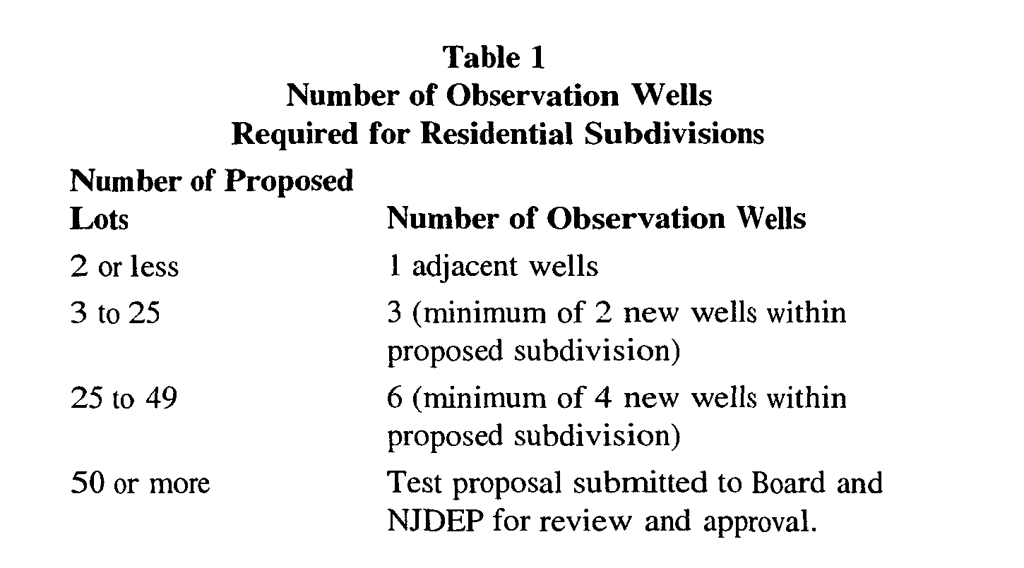
[xi] Major subdivisions of two new building lots or less to be used for single-family dwelling purposes shall conduct an aquifer test on each well as outlined in Ï 165-72C(8)(e)[2]. For major subdivisions of three or more new building lots to be used for single family homes, the recommended number of observation wells shall be as shown in Table 1.�
[xii] The observation wells and test well must have a geologic log describing the depth and types of soils and rocks encountered and the depth and yields of all water-bearing fracture zones. Furthermore, the logs should include static water-level measurements and total yield estimates for each well. The observation wells should be completed to a similar depth as the test well. At least one of the observation wells should be within 200 feet of the test well, and at least one observation well must be located along the preferential fracture direction between 200 and 500 feet of the pumping well. Additional observation wells should be located to evaluate potential secondary fractures and impacts to adjacent properties.�
[xiii] The design of the aquifer test shall be developed using the applicable guidance from "Guidelines for Preparing Hydrogeologic Reports for Water Allocation Permit Application with an Appendix on Aquifer - Test analysis Procedures" NJGS GSR 29 (1992 or most recent edition) or successor document. The aquifer test shall be conducted according to the following procedure:�
[A] Owners of existing wells on lots located within 500 feet of the subdivision boundary shall be given an opportunity to have their wells monitored during the aquifer test. Such opportunity shall be given by the applicant by notice via certified mail and shall give the time and place of the aquifer test. A letter acceptable to Clinton Township is included in Appendix A. The notice shall indicate that such existing well may be monitored if agreed to by the well owner provided the well is readily accessible. Such notice shall indicate that the existing well owner must respond within seven days and the applicant's responsibility is to monitor up to three wells on properties within 500 feet of the subdivision boundaries. If the owner of the lot within 500 feet of the subdivision boundaries decides to participate by agreeing to have their existing well monitored, they shall notify the applicant by certified mail. Such response shall be -provided within seven days of receipt of the certified notice from the applicant. If the applicant receives no response within the time provided, the response shall be deemed to be negative.�
[B] All reasonable efforts shall be made to protect the potability of water from the monitored well.�
[C] In the case when more than three property owners within 500 feet of the subdivision boundaries decide to participate and to have their existing wells monitored, only the three nearest to the test well need be monitored. However, if any of the property owners requesting monitoring have wells completed to a depth less than 100 feet, these wells must also be monitored in addition to the three nearest wells. A map depicting the location of all wells to be monitored and a list of all property owners within 500 feet of the subdivision boundary that requested monitoring is to be submitted to the Board for review and approval prior to implementing the test.�
[D] Prior to conducting an aquifer test, the applicant shall submit the design of such aquifer test including the location of wells to be monitored on adjacent lots and qualifications of the persons and firm who will be performing the test for review by the Township. Such review may include submission of such design to a qualified hydrogeologist retained by the Board for review and recommendations. The Board may consider the comments and recommendations of the Board's Hydrogeologist prior to approving the aquifer test plan. A fracture trace analysis showing the location and orientation of fractures beneath the site must be included with the aquifer test plan. This same analysis with additional information regarding septic system locations must be included in the final report. This fracture trace analysis should be used to identify all observation wells, which should be located along strike of the primary geologic fractures/structures on and near the property.�
[E] The aquifer test will be comprised of three phases. The first phase will involve the collection of background water levels prior to the start of the test. The second phase will involve the pumping of water from the well and the monitoring of water-level drawdown in the observation and pumping wells. The third phase will involve the recovery of water levels in the observation and pumping wells after the pump has been shutdown. This third phase of the test should be, at a minimum, the same length as the pumping phase.�
[F] The aquifer test (all three phases) shall not be conducted during a precipitation event or events in which total precipitation exceeds 0.5-inches. If precipitation occurs during the test, the applicant should provide precipitation amounts and sufficient data to show that the precipitation did not recharge the aquifer during the test and adversely impact the testing results. If precipitation amounts exceeding 0.5-inches are recorded, the test must be repeated.�
[G] The background phase includes allowing the test well and observation wells to stabilize for a minimum of three days before the test. At a minimum, water levels should be measured each hour from the test well and observation wells for a twenty-four-hour period prior to the start of pumping. It is the applicant's responsibility to collect sufficient data to determine background conditions and to ensure that antecedent influences can be fully characterized. Barometer measurements and additional water-level measurements can be made by the applicant to evaluate the change in water levels resulting from barometric pressure changes and/or influences from off-site pumping.�
[H] On the day of the pumping phase, water levels shall be collected from all wells. For those wells showing a change of more than 0.1 foot, a second round of measurements shall be collected before starting the test. Additional rounds of measurements may be necessary to determine that the well is in equilibrium. However, if the applicant has barometric pressure and water-level data to indicate that the change in static levels is due to changes in barometric pressure and/or antecedent influences, the applicant can submit these data in lieu of delaying the pumping phase.�
[I] The pump and discharge pipe shall be equipped with an orifice/manometer apparatus and calibrated flow meter to instantaneously measure flow rate and determine total volume pumped from the well. The discharge shall be directed so that it leaves the site without infiltrating to the aquifer. Any and all permits required by the NJDEP for the discharge of water must be obtained prior to starting the test.�
[J] When the pump is started the flow rate shall be adjusted immediately to a uniform pumping,rate as required for a constant-rate test and in accordance with the approved aquifer test plan. The flow rate shall not vary more than 10% throughout the test. If the flow rate fluctuates more than 10%, the test may be deemed invalid and the applicant required to repeat the notification and testing process.�
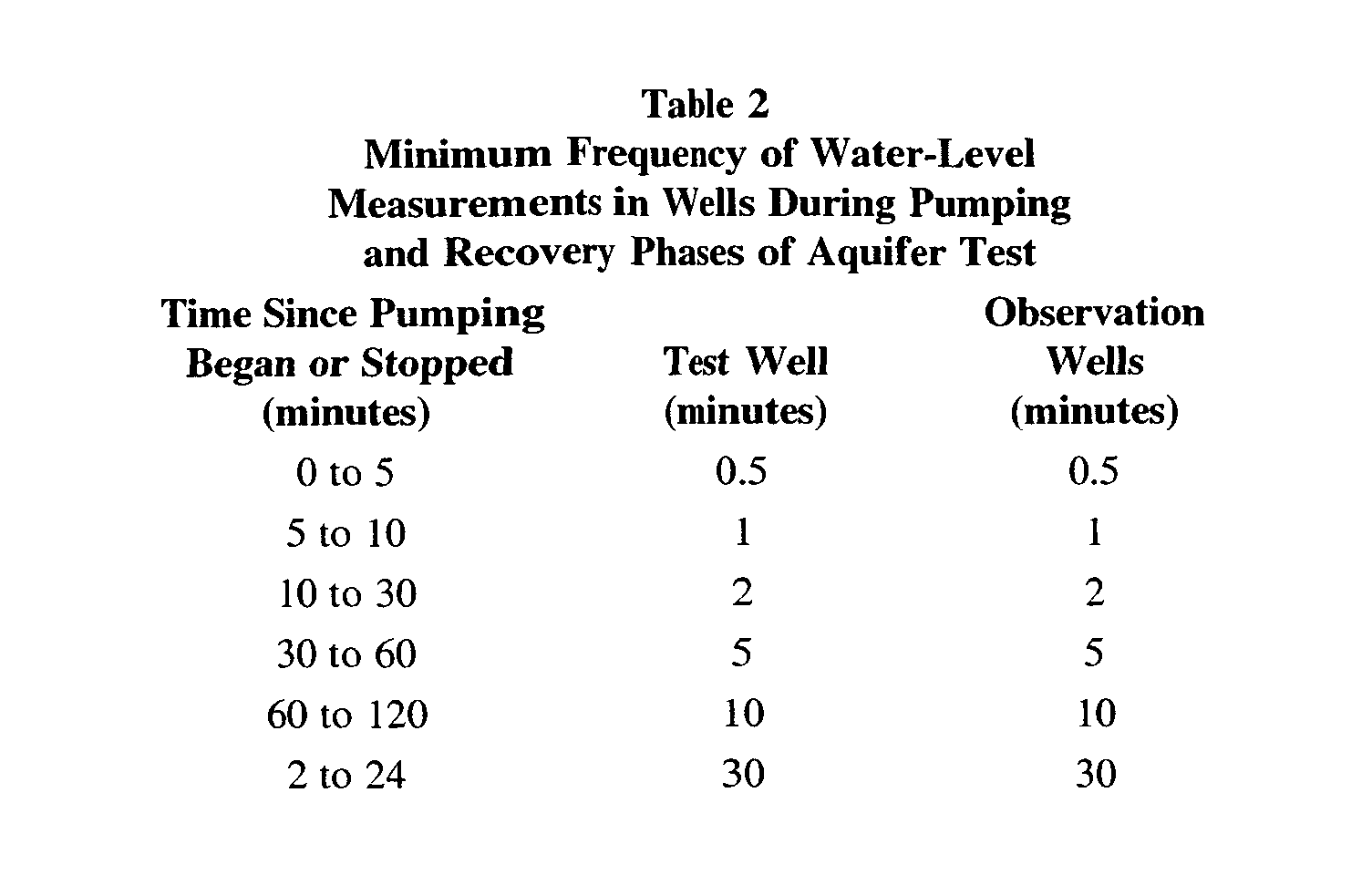
[K] Water-level measurements during the pumping phase of the test shall be collected in accordance with Table 2. This same schedule shall be followed for the recovery phase of testing upon shut down of the pump in the test well.�
[L] If the water levels in the observation wells and test well do not fully recover to static (prepumping) levels within a length of time since pumping stopped equal to the length of pumping, the test will be deemed to have failed unless adequate data can be provided to ensure that the aquifer is of sufficient extent to prevent the mining of groundwater.�
[M] Groundwater samples should be collected during the pumping phase from the pumping well. The samples should be collected in accordance with the NJDEP Field Procedures Manual. At a minimum, the samples should be analyzed by a NJDEP certified laboratory for hardness, iron, manganese, copper, lead, nitrate, chloride, and coliform bacteria. The samples shall also be analyzed for volatile organic compounds for which the USEPA or NJDEP has determined maximum contaminant levels. In addition, field measurements of pH, conductivity, and total dissolved solids should be made with calibrated instruments. If site conditions indicate potential historic uses of pollutants such as, heavy metals, pesticides, herbicides, and/or other volatile organic compounds, these analyses should be conducted. Based on past historical operations at the site or at nearby properties, the Board, at its discretion, may require additional analyses of groundwater to assess potential future and current impacts. The results of the water sample analyses will be used to assess background water quality. [N] The Board may choose to have a person of its choosing monitor the aquifer test.�
[b] Adjacent properties. The observation wells shall be placed to determine whether the cone of depression from the pumping well will extend beyond the subdivision boundary in any direction. This shall be determined by actual measurements or from projecting the drawdown based on observation well data. If the wells are in use, they should be allowed to stabilize before the pumping phase begins. A minimum of two water level measurements shall be collected from each well before the test. For any observation well which has been pumped within the 24 hours preceding the test, two depth to water measurements at least 1 hour apart shall be collected to show that the well has fully recovered prior to the start of pumping.�
[c] Hydrogeologic report.�
[i] A hydrogeologic report shall be provided with each major subdivision application. The report shall document the design and implementation of the aquifer test. The report shall include all water-level data collected during the three phases of testing, the calculations of aquifer characteristics such as transmissivity and storage coefficient, calculations of the cone of influence, potential impacts to adjacent well owners, and the long-term sustained yield for the wells. All water-level measurements obtained during the aquifer test shall be included with the report on a floppy disk or compact disk in ASCII text format. The report shall also evaluate and draw conclusions from the aquifer test based on data collected and evaluation of available information concerning geologic conditions. The report shall include a detailed hydrogeologic description of the aquifers encountered beneath the site and adjacent properties. The report must include a detailed evaluation of the water-supply demand for an average and peak day and this demand should be supported with information on anticipated population, expected dwelling unit density, and size of dwelling units. An inventory of all wells within 1,000 feet of the proposed subdivision boundaries should be appended. Figures depicting site geology, topography, water-level elevations, groundwater flow, and development plans shall be included.�
[ii] In addition, all water-quality sampling data shall be tabulated and summarized in the report. Only one copy of the laboratory reports is necessary for filing with the Township.�
[iii] The report should include a detailed evaluation of potential impacts from subsurface sewage disposal systems on groundwater quality. A site plan depicting well, septic leach field, and fracture trace locations at a minimum scale of one inch equals 200 feet should be included. For any and all locations where a fracture or set of fractures intersects one or more wells and/or septic leach fields, a detailed assessment of treatment technologies should be included. The treatment technologies should provide adequate assurances that any and all groundwater pumped from the wells will satisfy federal and New Jersey drinking water standards and will not be adversely impacted by the septic leach field discharges.�
[iv] The hydrogeologic report shall be prepared and signed by a qualified hydrogeologist using applicable sections of GSR 29 or successor document as a guide. A qualified hydrogeologist shall be an individual who has received a minimum of a bachelor's degree in geology at an accredited institution or has completed an equivalent of 30 semester hours of geological education while obtaining a Bachelor's or Master's degree in a related field of engineering or science at an accredited institution. Such a person must also demonstrate five years of professional work experience in the practice of applying geologic principals to interpretation of groundwater conditions. The individual should provide a resume or curriculum vitae to document education and experience requirements.�
[v] The hydrogeologic report shall include the name and license number of the well driller and pump installer. The report should include the names of the persons and firm responsible for collecting the water-level measurements. In addition, the report should include copies of the completed NJDEP well records.�
[vi] The aquifer test and analysis shall be deemed to have failed if such test cannot demonstrate to the satisfaction of the Board that sufficient groundwater supply exists to supply water via wells at a rate meeting at least the average daily demand for the proposed development. If the drawdown is measured or projected to be more than one foot at any existing adjacent property well or along the subdivision boundary, the applicant's hydrogeologist must evaluate the impact on adjacent properties based on the actual condition of wells in that zone.�
[vii] If a drawdown of five feet or more is noted in any existing adjacent property well, or is projected at any property boundary then the proposed subdivision shall have failed the aquifer test. In the event of a failed aquifer test, because a drawdown of five feet or more is noted in any existing adjacent property well or is projected at any property boundary, either the applicant should decrease the number of lots to lessen demand or demonstrate to the satisfaction of the Board that the impacts will not significantly reduce yields to existing and future wells.�
[2] Aquifer test and analysis for individual lots in a major subdivision of two new building lots or less and minor site plans�
[a] Procedure.�
[i] The procedure for testing wells for subdivisions of 2 or fewer new lots shall consist of pumping each of the subdivision wells individually for four hours at a minimum of five gallons per minute (gpm). During the testing of a well, no other subdivision wells shall be operating. If drawdown in the well exceeds 80% of the available drawdown in the well, the well is deemed to have failed the test. The available drawdown is determined by subtracting the static water level prior to pumping from the depth to the top of the pump. After pumping for two hours, the pump shall be shut down and the rate of recovery measured. For the well to pass the test, the pumping rate of five gpm must be maintained for the full four hours and a recovery rate of one gpm must be achieved over the first 30 minutes following shut-off of the pump.�
[ii] In order to provide the necessary data to evaluate the pump test results, the following conditions shall be met:�
[A] The well shall remain undisturbed for 3 days following drilling to allow aquifer conditions to stabilize.�
[B] Water level measurements shall be collected from the well and accessible adjacent wells (within 500 feet) before starting the pumping phase.�
[C] When the pump is turned on, the discharge rate shall be monitored and maintained at a minimum of five gpm. The flow rate must be measured with a calibrated flow meter or orifice/manometer apparatus.�
[D] Water levels in the pumping well and adjacent observation wells shall be collected according to the schedule in Table 2.�
[E] Near the conclusion of the pumping portion of the test, groundwater samples should be collected from the discharge in accordance with the NJDEP Field Procedures Manual. At a minimum, the samples should be analyzed by a NJDEP certified laboratory for hardness, iron, manganese, copper, lead, nitrate, ammonia, chloride, and coliform bacteria. The samples shall also be analyzed for volatile organic compounds for which the USEPA or NJDEP has determined maximum contaminant levels. In addition, field measurements of pH, conductivity, and total dissolved solids should be made with calibrated instruments. If site conditions indicate potential historic uses of pollutants such as, heavy metals, pesticides, herbicides, and/or other volatile organic compounds, these analyses should be conducted. Based on past historical operations at the site or at nearby properties, the Board, at its discretion, may require additional analyses of groundwater to assess potential future and current impacts. The results of the water sample analyses will be used to assess background water quality.�
[F] Immediately after the pump is shut off, water-level recovery shall be measured in accordance with Table 2 for a minimum period of four hours. The recovery rate shall be determined from these water-level recovery measurements for the first 30 minutes after the pump is shut down. The measurements should indicate a flow into the well of at least one gpm over this interval. If the water levels in the observation wells and test well do not fully recover to static (prepumping) levels within four hours after pumping has stopped, the test will be deemed to have failed unless adequate data can be provided to ensure that the aquifer is of sufficient extent to prevent the mining of groundwater.�
[G] In the event that the well shows little drawdown (less than five feet) during the four-hour pumping portion of the test, pumping may continue in lieu of the recovery rate portion of the teat. The minimum requirement for pumping after four hours is that a minimum rate of two gpm be maintained for an additional hour with no increase in drawdown. The recovery of the water level shall still be monitored for a minimum period of 30 minutes after the shut-off of the pump.�
[H] A report summarizing the well construction and aquifer testing shall be submitted to the Board. The report should include the water-level measurements and recovery rate calculations. The report must include a detailed evaluation of the water-supply demand for an average and peak day and this demand should be supported with information on anticipated population, expected dwelling unit density, and size of dwelling units.�
[I] The report should include the well driller's and pump installer's name and license numbers. In addition, the names of the person and firm that measured the water-level drawdown and recovery data, and calculated the recovery rate shall be provided. The report should include a copy of the completed NJDEP well record for all wells within the subdivision.�
[J] Based on the results of the testing and report, the Board may request additional analyses of the pumping phase data to evaluate aquifer characteristics, the potential cone of influence, and potential impacts to other nearby groundwater users.�
[iii] If the test well fails any part of the above test either by failing to maintain a pumping rate of five gpm for four hours, exceeding 80% of the available drawdown, or failing to recover at a rate of one gpm after pumping stopped, the well shall be considered unacceptable and the applicant shall either replace the well or deepen the well to intercept additional fractures or add additional well storage. After well replacement or deepening, the entire test procedure shall be repeated on the new or deepened well. If the new or deepened well fails the testing procedure, the lot may, at the discretion of the Board, be classified as unacceptable for development.�
[b] Adjacent wells.�
[i] Existing wells within 500 feet of the test well on adjacent lots shall be identified as observation wells for the test. The applicant shall notify the owners of adjacent lots which contain wells within 500 feet of the test well and such owners shall be given an opportunity to have their wells monitored following the same procedures set forth in Ï 165-72C(8)(d) through C(8)(e)[1][b]. In the case where more than three existing wells are located within 500 feet of the well to be tested, only the three nearest accessible wells need to be monitored. However, if any of the property owners requesting monitoring have wells completed to a depth less than 100 feet, these wells must also be monitored in addition to the three nearest wells. If the wells are in use, they should, if possible, be allowed to stabilize before the pumping phase begins. One water level measurement shall be collected from each well before the test. For any observation well which has been pumped within the 24 hours preceding the test, two depth to water measurements at least one hour apart shall be collected.�
[ii] If drawdown is measured or projected to be more than one foot at any existing adjacent property well or along the subdivision boundary, the applicant must notify the Township and evaluate the impact on adjacent properties based on the actual condition of wells, the static water level, and the depth of the pump in the existing well. The potential for adverse impacts needs to be evaluated by a hydrogeologist who will investigate the depth, yield, and pumping level of the effected well.�
[iii] If a drawdown of five feet or more is noted in any existing adjacent property well, or is projected at any property boundary then the proposed subdivision shall have failed the aquifer test. In the event of a failed aquifer test, because a drawdown of five feet or more is noted in any existing adjacent property well or is projected at any property boundary, either the applicant should decrease the water-supply demand or demonstrate to the satisfaction of the Board that the impacts will not significantly reduce yields to existing and future wells.�
[3] Aquifer test and analysis for nonresidential and residential site plans.�
[a] Testing.�
[i] An aquifer test shall be conducted when a nonresidential use or residential site plan is intended to be served by on-site groundwater supply. The aquifer test will be conducted in three phases, which are the background phase, the pumping phase, and the recovery phase. The pumping rate and total gallons pumped during the pumping phase should demonstrate that the needed water is available without detrimental impact on the aquifer or nearby wells.�
[ii] Demand shall be based on N.J.A.C. 7-10.12.6. If the demand exceeds 100,000 gallons per day, a New Jersey water allocation permit must be obtained from the New Jersey Department of Environmental Protection. For demands less than 100,000 gallons per day, the length of the pumping phase will equal the greater of the following: the volume of water removed from the aquifer is equal to the peak-day demand; or eight hours. The pumping phase should simulate peak-day demand and therefore, the pumping phase duration is not to extend more than 24 hours. The peak-day demand should be assumed to equal twice the average daily demand. The average daily demand shall be calculated from the projected maximum monthly usage.�
[iii] For nonresidential or residential developments with an expected average daily demand less than 2,000 gallons per day, one observation well is required. This well should be within 200 feet of the pumping well and along strike of the primary geologic fractures in the area. For developments with expected daily demands from 2,000 to 9,999 gallons per day, two observation wells are required. One of these observation wells must be within 200 feet of the pumping well. A second observation well must be "within 200 and 500 feet of the pumping well. These two wells should be located along strike of the major regional fractures and water-bearing fractures intersected by the well. If a well(s) on one or more adjacent properties are located within the distance limits above, and these wells can be disconnected for a period of 24 hours prior to and during the entire pumping and recovery phase, these wells can be used for observation in lieu of installing new observation wells.�
[iv] For all other nonresidential or residential developments, three or more observation wells are required. Two of these wells should be located along strike of the major water-bearing fractures intersected by the well and/or primary geologic fractures. Additional observation wells should be located to evaluate potential secondary fractures and impacts to adjacent properties. The number of observation wells should be in accordance with Table 3.�

