
[Amended 6-21-1989 by Ord. No. P-58; 12-2-1998 by Ord. No. R-357; 6-7-2000 by Ord. No. R-445; 10-17-2001 by Ord. No. DR-14; 5-15-2002 by Ord. No. DR-39]�
A. General conditions.�
(1) Site plan review and approval by the Planning Board shall be required as described below:�
(a) Site plan review shall be required for:�
[1] New construction or substantial alteration resulting in ten (10) or more dwelling units;�
[2] New nonresidential structures with more than five thousand (5,000) square feet of floor area;�
[3] Additions and alterations to existing, non- residential structures increasing by fifty percent (50%) or more the gross floor area or building coverage existing at the time of the passage of this section; and�
[4] Major parking facilities.�
[5] Wireless telecommunications towers subject to Section 196-35. [Added 5-7-2003 by Ord. No. DR-91]�
(b) Minor site plan review shall be required for:�
[1] New construction or external alterations resulting in three (3) to nine (9) dwelling units;�
[2] New nonresidential structures with three thousand (3,000) to four thousand nine hundred and ninety-nine (4,999) square feet of floor area; or�
[3] Additions and external alterations to existing nonresidential structures increasing by twenty-five percent (25%) to forty-nine percent (49%) the gross floor area or building coverage existing at the time of the passage of this section.�
[4] Any change in use or increase in intensity of use where the site occupant will require ten (10) or more additional parking spaces under the provisions of this chapter; such calculation is to be performed using the table provided in Section 196-44 for nonresidential uses located anywhere in the R-1 district and anywhere on Washington Street even though no parking is permitted on-site in those locations.�
[5] Any request for an increase in permitted occupancy of a nonresidential use as measured by either the Uniform Fire Code, BOCA or other applicable code.�
[6] Wireless telecommunications antennas subject to Section 196-35. [Added 5-7-2003 by Ord. No. DR-91]�
If the proposed site plan involves one (1) or more zoning discrepancies as specified in N.J.S.A. 40:55D-70d, the applications for site plan approval and zoning ordinance variance shall be submitted to the Zoning Board of Adjustment.�
(2) Site plans shall be submitted by the applicant to the appropriate Board for its review and action. Where a site plan involves a zoning discrepancy as described in N.J.S.A. 40:55D-70c, the Planning Board shall have the power to review the applications for site plan approval and a variance at the same time and render its decision thereon. If the proposed site plan involves one (1) or more zoning discrepancies as specified in N.J.S.A. 40:55D-70a, 40:55D-70b or 40:55D-70d, the applications for site plan approval and zoning ordinance variance shall be submitted to the Zoning Board of Adjustment for its review and decision on both. �
**Webmasters Note: The previous subsections, A(1) and A(2), have been amended as per Supplement No. 49.�
(3) Site plan review may be conducted concurrently with special review, planned development and conditional use procedures specified elsewhere in this chapter. If approved, a site plan shall be signed and dated by the Chairman of the Planning Board and transmitted to the Zoning Officer. A site plan which has been denied or approved with conditions shall be returned unsigned to the applicant with a letter stating the conditions or reasons for denial. A copy of the letter and plan shall be submitted to the Zoning Officer.�
(4) Where review is required by the Historic Preservation Commission, such review shall precede that of the Planning Board/Zoning Board which shall be informed of the Commission's findings by way of a written report or testimony given by a Commission member or staff person. See Sections 36-1 et seq. and 44-35 et seq. of the Code of the City of Hoboken for establishment of the Historic District and the Historic Preservation Commission and its procedures.�
B. Procedures. Detailed checklists are available from the Planning Board/Zoning Board Secretary along with proper application forms. The applicant must review the appropriate checklist and provide all appropriate attachments called for by the checklist in addition to the completed application form and applicable fees. All initial submittals must be made through the Planning Board/Zoning Board Secretary in a single packet. �
The initial submittal will be reviewed by the Board professionals to insure that proper administrative and escrow fees have been posted, that the items required in the checklist have been provided, and that the architectural and engineering plans and calculations are technically complete and in conformance with city ordinances. Applicant must specifically request, in writing, any variances and/or waivers being sought. The results of this initial review will be submitted to the Planning Board's Subdivision and Site Plan Committee with copies to the applicant and applicant's professionals as appropriate. If site plan approval is being sought from the Zoning Board, the results will be reviewed by the Application Review Committee. �
The Subdivision and Site Plan Committee of the Planning Board or the Application Review Committee of the Zoning Board will determine which review agencies must receive copies of the application. The applicant will be responsible for the distribution. Proof of distribution will constitute one of the required elements of completion prior to the hearing. Such proof shall be provided by the applicant in the form of certified mail receipts. Responses may be offered in writing or by way of expert testimony as the Board may decide. Final approval may be conditioned on adequate responses. �
Reasonable effort will be made to advise the applicant prior to the Committee meeting if the application is deficient and unable to be deemed complete. In any event, the application must be deemed complete by the Committee in order to be placed on the next Board agenda for a hearing. If the next agenda is full, applicant will be notified by the Board Secretary as to the hearing date. At such time, applicant will be required to make the necessary publications and notifications. �
Per Section 44-33 of the Code of the City of Hoboken, applicant must provide proof that no taxes or assessments for local improvements are due or delinquent on the property which is the subject of the application. If it is shown that taxes or assessment are delinquent on said property, any approvals or other relief granted by either Board shall be conditioned upon either the prompt payment thereof or the making of adequate provision for such payment in a manner that will adequately protect the municipality. Application fees must be paid up-to-date prior to being heard. Failure to do so will result in the application not being heard.�
(1) For Planning Board review, eight (8) completed copies of the application for site plan review and eight (8) full-sized and eight (8) reduced (11 x 17 inches) copies of each of the plan elements shall be submitted to the Planning Board Secretary at least twenty-one (21) days prior to the next regularly scheduled Subdivision and Site Plan Review Committee meeting. Individual packets are to be provided directly to the Board's Planner, Engineer and Attorney. For Zoning Board review, three (3) completed copies of the applications for site plan review and variance approval and, three (3) copies of each of the plan elements shall be submitted to the Zoning Board Secretary at least fourteen (14) days prior to the next regularly scheduled Application Review Committee meeting. Individual packets are to be provided directly to the Board's Planner, Engineer and Attorney. Consult the Secretary for the number of final submission sets for the Board hearing.�
(2) Within forty-five (45) days of the official date of receipt, the Planning Board/Zoning Board shall inform the applicant of any deficiencies in the application or preliminary plans, or the application will be deemed complete. If the application is incomplete, it shall be returned to the applicant for completion and resubmission.�
(3) Preliminary site plan approval shall be granted or denied by the Planning. Board in accordance with N.J.S.A. 40:55D-46 within forty-five (45) days of submission of a complete application to the Planning Board Secretary for a minor site plan of ten (10) acres of land or less and ten (10) dwelling units or less; within ninety-five (95) days for a site plan of more than ten (10) acres or more than ten (10) dwelling units; or, where the request includes a request for relief pursuant to N.J.S.A. 40:55D-60, within one hundred twenty (120) days. Failure of the Planning Board to act shall be deemed to be preliminary approval.�
Minor site plan approval shall be deemed to be final approval of the site plan by the Board, provided that the Board may condition such approval on terms ensuring the provision of improvements pursuant to N.J.S.A. 40:55D-38, 40:55D-39, 40:55D-41 and 40:55D-53. Failure of the Board to act within the period prescribed shall constitute minor site plan approval.�
(4) Upon submission of completed final plans to the Planning Board Secretary, the Planning Board shall grant or deny approval in accordance with N.J.S.A. 40:55D-50. Failure of the Planning Board to act within forty-five (45) days after submission of a complete application shall constitute final approval. Applications for final site plan approval shall be submitted for Planning Board review prior to beginning construction of the building or buildings receiving preliminary approval. Certificates and permits shall only be granted when an inspection by the Planning Board or its designated representative has verified the fulfillment of all conditions of final site plan approval. [Amended 5-7-2003 by Ord. No. DR-90]�
(5) In such cases as site plan review is conducted concurrently with applications for a variance, planned development or conditional use, public hearings and notice are required pursuant to N.J.S.A. 40:55D-12.�
(6) Whenever review of the application by the County Planning Board is required in accordance with Section 8 of P.L. 1968 (N.J.S.A. 40:27-6.6), the planning Board shall condition any approval that it grants on timely receipt of a favorable report by the County Planning Board or approval by the County Planning Board or approval by the County Planning Board evidenced by the failure to report thereon within the required time period.�
**Webmasters Note: The previous subsections, B(1) through B(6), have been amended as per Supplement No. 49.�
(7) An application not acted on within two (2) years of its approval shall be subject to the conditions of N.J.S.A. 40:55D-52. Decisions on appeals and development applications shall be granted or denied by the Zoning Board in accordance with N.J.S.A. 40:55D-73 within one hundred twenty (120) days (or within such further time as may be consented to by the applicant) of submission of a complete application to the Zoning Board Secretary. Failure of the Zoning Board to act shall constitute a decision favorable to the applicant.�
C. Standards for site plan drawings. Site plan drawings shall be submitted at a scale of one (1) inch equals fifty (50) feet for tracts under one (1) -acre in size and at a scale of one (1) inch equals eighty (80) feet for tracts up to ten (10) acres. All plans shall be signed and sealed by a professional as required by the state, folded with Title Block revealed.�
D. Required submissions. Detailed checklists for preliminary, minor and final site plan as well as for minor and major subdivision applications are available from the Planning Board/Zoning Board Secretary along with proper application forms which may be revised from time to time. The checklist below applies to preliminary site plan review. The applicant must review the appropriate checklist and provide all appropriate attachments called for by the checklist in addition to the completed application form and applicable fees. Ten (10) copies of each submission showing details of the following categories shall be submitted: building and impact; circulation; landscaping; facilities and utilities; topography; zoning compliance; recycling; and a signed and sealed survey.�
(1) The building and impact plan shall include drawings which show the following:�
(a) Ground floor/site plan clearly showing lot lines and lot numbers of the subject site, as well as lot numbers of adjoining lots; proposed yards and building setbacks; location of buildings on adjacent lots; name, width and. direction of travel of adjoining street(s) with distance to intersection indicated; north arrow;�
(b) Key/location map showing zoning district boundaries;�
(c) Two hundred (200) feet radius diagram showing tax block -and tax lot numbers within two hundred (200) feet of the site;�
(d) Signature block.�
(2) A written neighborhood impact report shall describe the proposed use or uses of the buildings, proposed numbers of employees and/or residents, projected vehicular traffic, anticipated generation of noise, glare, heat, odor and vibration, possible, safety hazards, and anticipated future expansion; a detailed traffic impact report shall be provided for any project providing fifty (50) or more parking spaces on-site.�
(3) A circulation plan shall show access roads curbs�
(4) curb cuts, paths,,, driveways, -parking and loading facilities, interior circulation arrangements for vehicles and pedestrians and arrangements for exterior lighting; see checklist for details. A landscaping plan shall show the.. location and characteristics of buffers and screening whether, fencing or plant material, trees, and plantings; 'see checklist for details.�
(5) A facilities and utilities plan shall show existing and proposed locations of facilities and utilities providing for water, sewerage, storm drainage, electricity, gas, fire protection and solid waste disposal. Provisions for underground distribution of electrical and signal utilities shall be shown.�
(6) A topographic plan shall show existing elevations on the subject site. Show proposed spot elevations per checklist. A written notation shall be provided to indicate the site's relation to flood hazard boundaries as shown on the FEMA Flood Hazard Map.�
(7) A zoning compliance table shall show all relevant district regulations (use, bulk, parking, standards for conditional uses, etc.) as set forth in Chapter 196, providing the numerical section references in the first column. For each regulation, the table shall compare district requirements with values for the proposed project. The table shall indicate any values for the project which do not conform to district regulation standards in a column indicating "variance required." Additionally, where required standards or limitations are based on such characteristics as the number of dwelling units, square footage of customer service area percentage of roof area, prevailing height or front yard setback, etc. the calculation and/or a sketch must be provided. Instructions for calculating compliance with the facade and density regulations are available from the Board Secretary.�
(8) A recycling plan shall show what materials will be collected, where they will be stored, where and by whom they will be picked up and with what frequency, the amount of material projected to be generated and how much storage area will be required for each material. See Section 196-26.1 for state and local minimum standards for projecting and providing storage and handling space.�
(9) A survey signed, sealed and dated by a licensed land surveyor shall be submitted with site plan review applications as well as with subdivision requests; the survey should clearly show all existing buildings on site. A copy of a survey shall be submitted with development applications requesting variances only.�
E. Considerations. In considering and approving site plans, the Planning Board shall take into consideration the public health, safety and general welfare, the comfort and convenience of the general public and the general purposes and intent of this chapter.�
[Added 12-2-1998 by Ord. No. R-357]�
A. Purpose and application. Pursuant to the "Statewide Source Separation and Recycling Act," the City of Hoboken has adopted both a recycling plan and a Recycling Plan Element to effectuate the goals of the state and county to recover a mandated percentage of the municipal solid waste stream. Through site plan review, subject developments are to provide adequate and proper space per the standards presented below.�
B. Standards for storage.�
(1) Residential development: sufficient storage for a week's worth of recyclables shall be provided both within each dwelling unit and, if a multi-family building, in a common area as, specified below.�
(a) Size: sufficient for eight (8) gallons of storage in each unit; three (3) square feet for each three-tier stack unit or for three (3) to four (4) gallon buckets.�
(b) Location.�
[1] Multi-family: under kitchen sink or in closet of each dwelling unit as well as in a common area near the refuse receptacle or 4 laundry room (preferably on each floor); a central storage area should be located so as to facilitate pick-up.�
[2] Single-family homes: same as for apartment or in laundry room, basement or garage.�
(2) Commercial/industrial development: sufficient storage space for a week's worth of recyclables.�
(a) Size: if development generates a large volume of recyclables, the loading dock area shall be of a sufficient size to hold small dumpsters, fifty-five (55) gallon containers or 4'x4'x4' Gaylord containers or hampers which can be picked up by a fork lift. If a nonresidential use is not large enough to require a loading dock under the provisions of the Zoning Ordinance, the recycling plan shall provide for pick-up times frequent enough to make large storage areas unnecessary.�
(b) Location: storage shall be provided indoors or, if outside, it shall be screened by a shed-like enclosure.�
C. Standards for projection.�
(1) Average generation rates are as follows:�

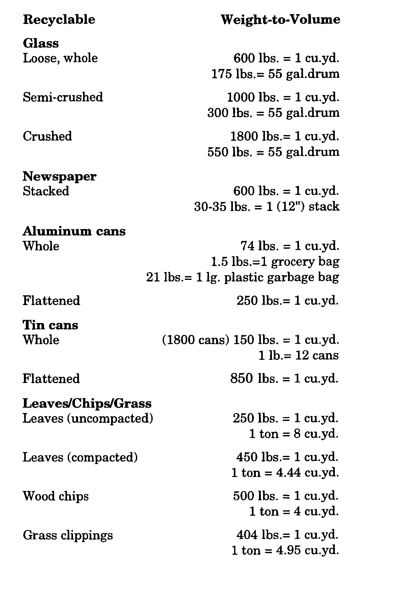
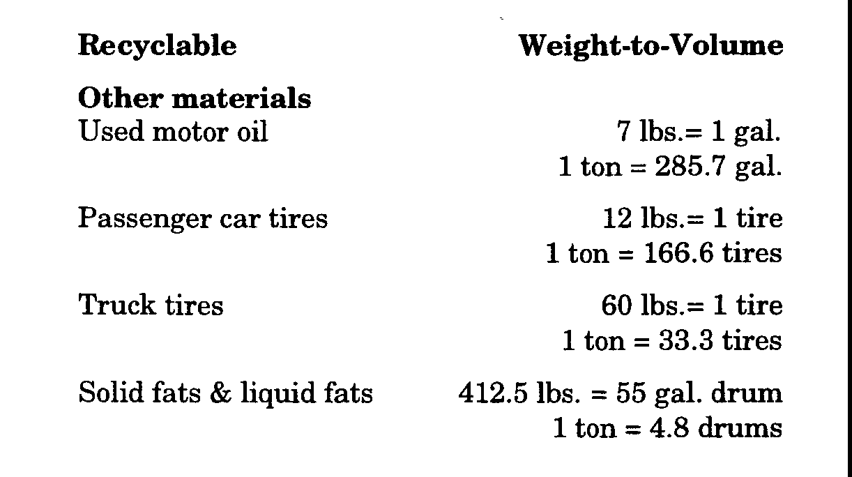
(2) Weight-to-volume ratios: some of these items may not be permitted at the time of application (it is the applicant's responsibility to refer to the local recycling ordinance and related regulations at the time of submission to determine which items are to be recycled and in what form - crushed, in paper bags, etc.).�
**Webmasters Note: The previous sections, 196-26 through 196-26.1(C)(2), have been amended as per Supplement No. 47.�
[Amended 6-21-1989 by Ord. No. P-58; 3-15-1995 by Ord. No. R-116]�
The R-1(E), R-1(CS), R-1(H)(CPT), CBD(H), CBD(H)(CS), W(RDV), W(H), W(N), and 1-1(W) Subdistricts are designed to provide flexibility to district regulations. The subdistricts further the public interest by subtracting permitted district uses in the Higher Education Subdistrict and increasing district requirements in the Historic Subdistrict. [Amended 11-142005 by Ord. No. DR-209]�
A.R-1(E) Higher Education Subdistrict. The R-1(E) Subdistrict isolates uses peculiar to higher education from the remainder of the district while acknowledging functional, economic:,: social and geographical relationships between the subdistrict and the larger district.�
B. CBD(H) Historic Subdistrict. The CBD(H) Subdistrict provides an additional review function within the portion of the CBD designated as an historic district by incorporating the provisions of the local ordinance establishing an historic district and the Historic District Commission. Any application for a building permit to erect a new building, or to demolish or to alter the height, bulk, setback, location or exterior appearance of an existing building in the CBD(H) Subdistrict shall be subject to review by the Historic District Commission and such further action as may be authorized by local ordinances. Reviews and recommendations by the Historic District Commission shall not supersede the powers and responsibilities of other local legislative or regulatory bodies but shall be taken into consideration by the Planning Board and Zoning Board of Adjustment in issues of mutual concern.�
C. Court Street (CS) Subdistrict. The Court Street Subdistrict is intended to preserve the distinctive scale and architecture of structures fronting on Court Street and to promote new development compatible with this unique service alley's limited accessibility to utilities and city services such as fire protection and sanitary services. Those portions within the CBD(H) Subdistrict are subject to review procedures by the Historic District Commission.�
D. I-1(W) Subdistrict. The I-1(W) Subdistrict is designed to acknowledge the shift in demand for riverfront property from nonresidential to residential uses while protecting existing employing units and employment opportunities.�
E. W(H) Subdistrict. The W(H) Subdistrict indicates the location of a segment of the city's historic district within W-District boundaries. That segment is subject to review procedures by the Historic District Commission.�
F. W(RDV) Subdistrict. The Waterfront Redevelopment Subdistrict represents the plan area within which the Waterfront at Hoboken, South Redevelopment Plan applies.�
G. W(N) Waterfront North Overlay Subdistrict. It is intended that the view of the bluffs associated with Castle Point along the Hudson River Waterfront be preserved as a natural amenity of the city. Therefore, all development located within this subdistrict shall be subject to a height limitation, restricting such development to no more than thirty-five (35) feet in height. Permitted and conditional uses shall be otherwise the same as those established for the remainder of the W Waterfront District. [Added 11-171989 by Ord. No. P-87]�
H. R-1(H)(CPT) Castle Point Historic Subdistrict. The purpose of the Castle Point Historic Subdistrict is to reinforce and safeguard the heritage of this area which has been one of the most prestigious neighborhoods in Hoboken. This subdistrict which is also designated the "Castle Point Historic District" is distinguished by being the only neighborhood in the city typified by large, freestanding one (1)- and two (2)- family homes. Through architectural and bulk controls, the height and density will be limited to maintain the historic character. [Added 11-14-2005 by Ord. No. DR-2005]�
**Webmasters Note: The previous section has been amended as per Supplement No. 53.�
[Added 6-21-1989 by Ord. No. P-58; amended 11-17-1989 by Ord. No. P-87; 4-18-1990 by Ord. No. P-103; 3-15-1995 by Ord. No. R-116; 9-6-1995 by Ord. No. R-141]�
A. Urban design review is intended to be applied to planned developments in the I-1(W) District because of the unique characteristics of this district. Urban design review procedures are set forth in this section to ensure that any new planned development in this district will be compatible with its location and within the context of existing and proposed development. Such new development shall also further the purposes of this section and of the land use plan element of the Master Plan, as it may be amended. In the event of conflict between any provision of the urban design review (§ 196-27.1) and any other provision of this chapter, the urban design review provision shall prevail.�
B. Action by the Planning Board. The Planning Board shall review an application for urban design review in accordance with procedures for site review set forth in § 196-26. Prior to approving any planned development, the Planning Board shall find the facts and conclusions required under N.J.S.A 40:55D-45 and make such further findings as are required under any other provisions of the Municipal Land Use Law (N.J.S.A. 40:55D-1 et seq.). In its review, the Board shall also find that the applicant meets the following requirements:�
(1) That the development creates a vehicular and pedestrian circulation system of streets (either public or private), pathways and public open space which advance the following�
(a) Creation of a street system which:�
[1] Interconnects with existing and adjacent streets in a design demonstrated by applicant's traffic studies to optimize traffic flow in and out of the planned unit development;�
[2] Where a planned unit development is adjacent to any western bypass road (as discussed in the Circulation Plan Element of the City Master Plan) as may be constructed, it shall provide a linkage to such road thereby permitting access to the northern waterfront sector of the district by passing beneath the Park and Willow Avenue viaducts. If such bypass road has not been constructed at the time the subject planned unit development application is submitted, the layout of the planned unit development shall not preclude any future linkages.�
[3] Creates a development block pattern which provides the framework for the application of § 196-27.1B(3).�
[4] Creates and maintains view corridors (at street level) of the Hudson River primarily along the lines of adjacent east-west streets south of and including Fifteenth Street, and view corridors of Weehawken Cove primarily along the lines of adjacent north-south streets west of and including Hudson Street.�
[5] Where a developer chooses to make streets private he shall provide permanent public easements over all such streets in order to insure public access to the water's edge. [Added 10-18-1995 by Ord. No. R-146]�
(b) Creates a pedestrian circulation system and open space system which provides public access to and along the edge of the Hudson River and Weehawken Cove, built in conformity with at least the minimum standards of the New Jersey Department of Environmental Protection per Section 7:7E-8.11 "Public Access to the Waterfront, N.J.A.C. 7:7E-1.1, et. seq.�
(2) That off-street parking provisions are, at a minimum:�
(a) In conformity with the provisions of Article XI.�
(b) If a project is phased and accessory parking is not located in the principal building, parking facilities shall be completed prior to the issuance of certificates of occupancy.�
(c) On-site parking facilities shall be within enclosed structures or, if in open areas, as permitted under § 196-17F(2)(b), parked vehicles must be shielded or screened in such manner as substantially to prevent them from being observed from grade level outside the planned development. Such shielding may be provided by buildings, landscaping, fences or walls within the planned development. Rooftop parking shall provide screening with structures, landscaping, horizontal trellises, etc. sufficient to screen twenty percent (20%) of the parking area. Trees shall be shown at their mature size in order to calculate coverage.�
(d) The exterior wall materials and design of enclosed parking facilities located within a residential or commercial building shall be designed to the greatest extent practicable, the materials on the exterior walls of the building in which the parking is located or, in the case of a freestanding parking structure, adjacent buildings in the planned development.�
(3) That the following bulk controls have been applied:�
(a) Rear walls of residential buildings shall not be more than seventy (70) feet from the street line of any public or private street [except in the case of residential buildings located within one hundred fifty (150) feet of the intersection of two (2) streets, which buildings may have rear walls located not more than one hundred twenty-five (125) feet from the street line].�
(b) Building coverage for any one (1) development block shall not exceed seventy-five percent (75%), so long as average building coverage for all development blocks does not exceed sixty-five percent (65%); provided, however, that where a parking structure is created under the principal building, up to four (4) stories may cover up to one hundred percent (100%) of the development block. Such stories of the building shall be excluded from the calculation of building coverage so long as the following conditions are met:�
[1] The rooftop of the parking structure shall be landscaped and designed for the use and enjoyment of occupants of the building, and�
[2] The stories of the building containing the parking levels fully comply with the requirements of § 196-27.1B(2)(d).�
(c) Any development block within a planned development containing one (1) or more residential buildings shall contain an open area for light and air [having no dimension less than thirty percent (30%) of the block width] commencing no higher than the level of the lowest residential floor facing the interior of the block. Open areas above buildings or structures, on-grade parking lots, driveways, sidewalks and other surfaces may satisfy this requirement.�
(4) That there is compatibility with adjacent existing and proposed development concerning but not limited to the following.�
(a) Vehicular and pedestrian circulation.�
(b) Infrastructure improvements.�
(c) Where applicable, public access to the waterfront and/or public open spaces.�
(d) A minimum dwelling unit size of four hundred (400) net square feet.�
(5) Uses: Planned unit development may include the following uses: residential, commercial (except auto-related sales and service), bars, restaurants and riverborne public transportation as set forth in § 196-38S. Any of the above uses which are also set forth in § 196-17D(2) shall not be considered conditional uses in planned unit developments. Major parking facilities shall not be considered conditional uses in planned unit developments.�

