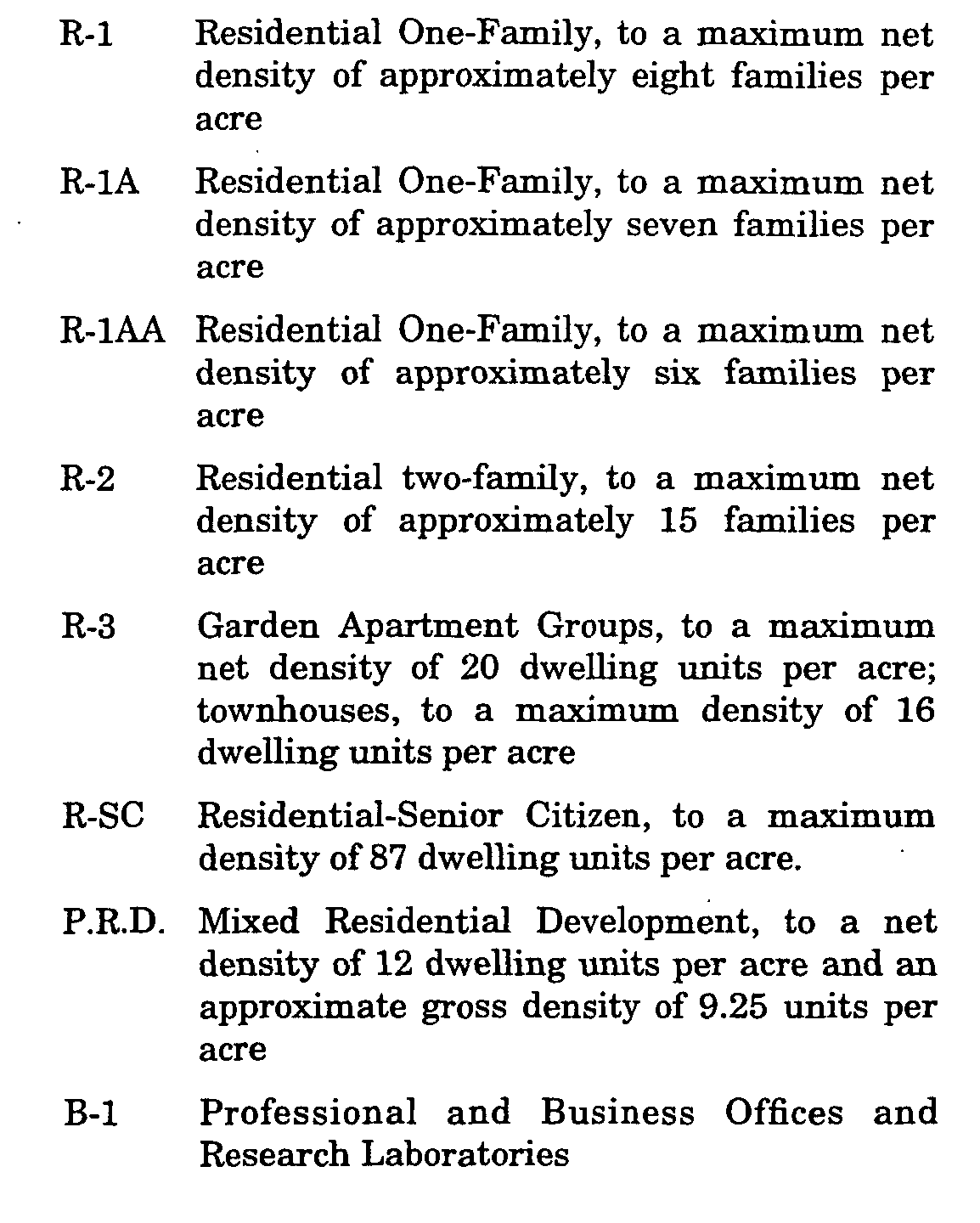
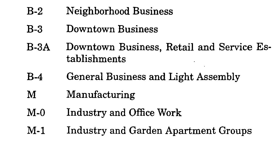
A. The territory of the Township is hereby divided into the following 15 classes of zoning districts:�


B. The aforesaid districts are hereby established by the designations, locations and boundaries thereof set forth and indicated on a map entitled "Township of Nutley, N.J., Zone Use," which map is hereby annexed and adopted as a part of this chapter insofar as it indicates said designations, locations and boundaries;' except that the designations, locations and boundaries of the R-1AA Zone, P.R.D Zone and part of the R-SC Zone are not set forth in said map, but are specifically set forth hereafter by block and lot as they appear on the current Township of Nutley Tax Maps.�
(1) R-IAA Zone.�
(a) Area A: Block 204A, Lots 1, 3, 4, 6, 7, 9, 10 and 12; Block 204B, Lots 3, 4, 6, 7, 8, 10, 11 and 14; Block 210, Lots 14, 15A, 16, 17 and 18; Block 210B, Lots 18, 19, 21 and 21A; Block 212A, Lots 1, 3, 5, 6, 7 and 8; and Block 212, Lots 1, 2, 3 and 5.�
(b) Area B: Block 265, Lots 1, 2, 4, 9, 12, 14, 15, 17,19, 21 and 23; Block 266, Lots 1 and 3; Block 257, Lots 73, 74, 75, 77, 80, 81 and 82; Block 428, Lots 18, 19, 20, 22, 27, 30, 33, 34, 36, 40 and 41; Block 448, all lots; Block 450, all lots; Block 453, Lots 5, 7, 12, 20, 20A, 20B, 22, 24,28, 34, 36, 40, 44, 46, 47, 49, 51, 53, 57, 63 and 65; Block 454, all lots; Block 456, Lots 1, 2, 5, 6,8, 9, 11, 12, 13, 14, 14A, 19, 19A, 21, 25 and 29; Block 455, Lots 1, 2, 8, 13, 37 and 40; Block 473, Lots 1, 3, 5, 7, 14, 17 and 19; Block 469, Lots 33,36, 39, 42 and 43; Block 433, all lots; Block 437, Lots 20, 24, 29, 32, 25, 38, 39 and 40; Block 435, Lots 10, 12, 15, 15A, 20, 21, 22, 25, 26 and 27; Block.432, all lots; Block 430, all lots; Block 429, Lots 8, 10, 15, 18, 22, 26, 28, 30, 34, 38, 40,41,42, 44, 45, 46, 51, 53, 56, 57, 59, 63, 67 and 68; Block 427, Lots 1, 3, 6, 8, 9, 33, 36, 39, 42, 45, 47, 51, 52, 53, 54, 55 and 60; and Block 426, Lots 1, 2, 5, 7, 40, 44, 48, 50, 51, 54, 57 and 61�
(c) Area C: Block 233, Lots 13, 16, 18, 21, 23 and 25; Block 236, Lot 10; Block 248, all lots; Block 239, Lots 22, 25, 29 and 31; Block 250, Lots 11,14, 18, 21, 22 and 24; and Block 249, all lots.�
(2) P.R.D. Zone. Block 458, lot 2; Block 464, Lot 1; Block 480, Lot 1; Block 486, Lots 1, 1A and 50; Block 504, Lots 1, 17, 24, 27, 29, 30 and 32; Block 510, Lots 1 and 50; and Block 512, Lots 1, 1A and 50.�
(3) R-SC Zone. Block 175, Lot 16.�
In construing the map, the following rules shall apply:�
A. Where such boundaries are indicated as approximately following the center lines of streets, alleys, railroads, waterways or the boundary lines of parks or other publicly owned land, such lines shall be construed to be such boundaries.�
B. Where such boundaries are indicated as approximately following the lines of lots or other parcels of record and are not more than 10 feet distant therefrom, such lot or parcel lines shall be construed to be such boundaries.�
C. Where a district boundary divides a parcel of land, the location of such boundary, unless the same is indicated by dimensions shown on the map, shall be determined by the use of the scale appearing thereon.�
Except for subdivisions approved after January 1, 1979, or those lots or parcels which conform to the Nutley Schedule of Regulations as to Bulk, Height and Other Requirements, all lots or parcels that are situate in the same residential zone and are contiguous, in common ownership and containing only one principal conforming use shall be considered as merged into one lot for the purpose of this chapter. The Tax Assessor is directed to remove all lot lines between such lot or parcels as soon as practicable. Notwithstanding the existence of lines creating separate lots on the Tax Map, such lines shall be deemed as removed for the purposes of this chapter.�