
[Amended 5-17-94 by Ord. No. 0-13-94]
No development in the Pinelands Area of the township shall be carried out by any person unless it is in conformance with each of the standards set forth in this Article. These standards are requirements of the Pinelands Comprehensive Management Plan, Part II, Article 6 (N.J.A.C. 7:50-6.1 et seq.). Certain of the Pinelands standards are contained elsewhere in the Winslow Township Code, as amended. In particular, the Pinelands standards for landfills, resource extraction and individual on-site sewage disposal systems are found in the following respective chapters of the Winslow Code in accordance with amendments made to these chapters: Chapter 135, Dumping, Article III, Pinelands Standards for Landfills; Chapter 179, Natural Resources; and Chapter 218, Sewage Disposal Systems, Individual. Development in the Pinelands Area of the township that involves landfills, resource extraction operations or the installation and operation of individual on-site sewage disposal systems shall conform with those requirements, in addition to any of the standards contained under this Article. Within the Pinelands Area, all applications for development approval shall be referred to the environmental commission for review and comment.
A. Within the Pinelands Area of the township, all agricultural activities and fish and wildlife management activities, including the preparation of land and the planting, nurturing and harvesting of crops, shall be carried out in accordance with recommended management practices established for the particular agricultural activity by the New Jersey Department of Agriculture, the Soil Conservation Service and the New Jersey Agricultural Experimental Station at Rutgers University.
B. In the Agricultural Zoning District a resource conservation plan shall be prepared by the operator of every agricultural use, or the appropriate soil conservation district, located in an area which has been designated by any agency of Federal, State or local government as having substandard surface or ground water. If prepared by the operator, such plan shall be submitted to the soil conservation district for review. The resource conservation plan shall be reviewed, updated and revised as necessary and shall provide for the use of recommended management practices as found in, but not limited to, the following publications:
(1) Erosion and Runoff - Soil Conservation Service Technical Guide.
(2) Animal Waste - Soil Conservation Service Animal Waste Management Field Manual.
(3) Fertilizers and Pesticides - Rutgers University, Cook College, Cooperative Extension Service Annual Recommendations.
[Amended 5-24-89 by Ord. No. 0-27-89]
A. All development shall adhere to the relevant air quality standards of N.J.A.C. 7:27 et seq. Adherence to the standards of this section shall be determined by means of an air quality simulation model approved by the New Jersey Department of Environmental Protection pursuant to N.J.A.C. 7:27-18.3. [Amended 2-25-97 by Ord. No. 0-2-97]
B. Applications for the following developments shall ensure that all state ambient air quality standards in N.J.A.C. 7:27 et seq. for carbon monoxide shall not be exceeded at places of maximum concentration and at sensitive receptors:
(1) Residential development of fifty (50) or more units and any other development involving more than one hundred (100) parking spaces located in the PR-2, PR-3, PR-4, PTC, PC-1, PC-2 or PI-1 Districts; and [Amended 3-26-02 by Ord. No. 0-6-02]
(2) Residential development of one hundred (100) or more units and any other development involving more than three hundred (300) parking spaces located in the PP, PRC, PA, PR-1, PR-5, PR-6 Ancora, PC-3, PC-4, PI-2 or PI-3 Districts. [Amended 7-20-93 by Ord. No. 0-20-93; 3-26-02 by Ord. No. 0-6-02]
[Added 4-28-98 by Ord. No. 08-98]
A.Definitions. As used in this section, the following terms shall have the meanings indicated:
(1) ANTENNA - Any exterior apparatus designed for radio communication through the sending and/or receiving of electromagnetic waves.
(2) TOWER - Any structure that is designed and constructed primarily for the purpose of supporting one (1) or more antennas or other radio equipment, including self-supporting lattice towers, guy towers, or monopole towers.
(3) FCC - The Federal Communications Commission.
(4) HEIGHT - When ref erring to a tower, the distance measured from ground level to the highest point on the tower or other structure, even if said highest point is an antenna.
(5) GOVERNING BODY - The Mayor and Township Committee of the Township of Winslow.
B. Applicability: This section shall only apply to amateur radio, ham radio and civilian band radio operators with or without a booster (amplifier) which are accessory to otherwise permitted uses. The erection of any type of tower, including but not limited to self- supporting lattice towers, guy towers, or monopole towers for transmission or reception of radio waves, shall be permitted in any zone within the township unless precluded by another Federal or State law or regulation, on the condition that the following requirements are satisfied:
(1) Towers shall be of a height not in excess of sixty-three (63) feet including the height of any antenna on said tower.
(2) Towers may be located in any zone within the township and shall be located within the property lines excluding the front yard and side yard, but only excluding that portion of the side yard which extends beyond the front of a residential or commercial structure.
(3) Towers must satisfy the minimum zoning district bulk requirements for accessory uses in each zoning district in which said tower is located, with the exception that side yards shall be a minimum of fifteen (15) feet in all residential districts.
(4) Towers shall be equipped with an appropriate anti climbing device.
(5) All towers must meet or exceed current standards and regulations of the FCC or any other agency of the Federal government with the authority to regulate such towers and/or antennas. To the extent that such standards and regulations are amended from time to time, then this section shall be deemed amended to comply with said regulations. The owners of all such towers and/or antennas governed by this section shall bring such towers and antennas into compliance with such revised Federal regulations within the time lines as required under such Federal regulations.
(6) Towers and/or antennas which are accessory to otherwise permitted uses located on any property owned, leased or otherwise controlled by the governing body shall be exempted from the requirements of this section. In the Pinelands Area, such accessory towers and/or antennas shall not exceed a height of two hundred (200) feet.
(7) Towers shall be either of a galvanized steel finish or shall be an earth tone or sky-like color so as to reduce visual obtrusiveness, unless required to be painted a different color by any other Federal or State agency.
C. Abandonment. Any antenna or tower that is not operated for a continuous period of twelve (12) months shall be considered abandoned, and the owner of such antenna or tower shall remove same within thirty (30) days of receipt of notice from the township governing body notifying the owner of such abandonment.
D. Interference. It shall be the responsibility of the owner of any such tower or antenna described in this section to correct any interference with pacemakers or medical devices, which is causally related to the operation of the tower or antenna.
A.. Development proposals, as much as is practicable, shall incorporate energy conservation measures and devices to reduce energy consumption and to provide for the maximum utilization of renewable energy sources.
B.. New streets shall be oriented to permit, within the limits of practicability and feasibility, the construction of buildings thereon to maximize solar gain and the use of renewable energy sources.
A. All applications for development in the Pinelands Area of the township shall demonstrate conformance with the standards for fire management, as outlined below.
B. [Amended 3-22-89 by Ord. No. 0-19-89] Fire hazard classes.
(1) The potential fire hazard for any parcel of land proposed for development shall be determined according to the following fire hazard classes:
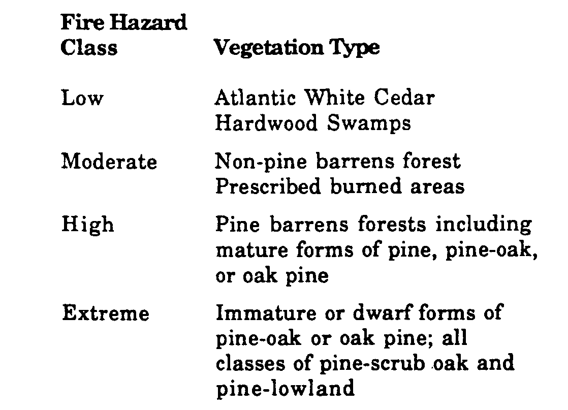
(2) The appropriate fire hazard class for a particular parcel of land can be obtained by referring to the Vegetation Map in the township's Natural Resources Inventory, supplemented by an on-site inspection to determine true height and spacing, as is necessary.
C. For lands classified as moderate, high and extreme fire hazard areas, all roads shall conform with the following standards:
(1) All new residential development of twenty-five 125) units or more shall have two (2) accessways of a width and surface composition sufficient to accommodate and support fire-fighting equipment.
(2) [Amended 5-24-89 by Ord. No. 0-27-89] All dead-end roads will terminate in a manner which provides safe and efficient entry and exit for fire equipment.
(3) The rights-of-way-of all roads shall be maintained so that they provide an effective fuel break.
D. For lands classified as moderate. high and extreme fire hazard areas, a fire hazard fuel break shall be provided around structures proposed for human use by selectively thinning, mowing or pruning and maintaining on an annual basis the shrubs, understory trees, bushes and ground cover and removing all dead plant material. These fuel breaks shall be at widths. measured outward from the structures as follows:
(1) Moderate fire hazard areas: thirty (30) feet.
(2) High fire hazard areas: seventy-five 1751 feet.
(3) Extreme fire hazard areas: one hundred (100) feet.
E. Fire hazard fuel breaks within lands classified as extreme fire hazard areas shall contain no pine tree (Pinus species) that is within twenty-five (25) feet of another pine tree.
F. All applications for development of one hundred (100) or more dwelling units on lands classified as high or extreme fire hazard areas shall have a two-hundred-foot perimeter fuel break between all structures and the forest, in which:
(1) Shrubs, understory trees and ground cover are selectively removed, mowed or pruned and maintained on an annual basis.
(2) All dead plant material is removed.
(3) Roads, rights-of-way and wetlands are incorporated into the fuel break to the maximum extent practicable.
(4) There is a specific program for maintenance.
G. All new structures proposed for development in the Pinelands Area of the township shall meet the following specifications:
(1) Roofs and exteriors will be constructed of fire resistant materials such as asphalt rag felt roofing, tile, slate, asbestos cement shingles, sheet iron, aluminum or brick. Fire retardant-treated wood shingles or shake type roofs are prohibited in high or extreme fire hazard areas. [Amended 524-89 by Ord. No. 0.27-89]
(2) All projections, such as balconies, decks and roof gables, shall be constructed of fire-resistant materials or materials treated with fire-retardant chemicals.
(3) Any openings in the roof, attic and the floor shall be screened.
(4) Chimneys and stovepipes which are designed to burn solid or liquid fuels shall be equipped with screens over the outlets.
(5) Flat roofs shall be prohibited in areas where vegetation is higher than the roof.
A. No development shall be carried out in the Pinelands Area unless it is designed to avoid irreversible adverse impacts on habitats that are critical to the survival of any local populations of those threatened or endangered animal species designated by the Department of Environmental Protection pursuant to N.J.S.A. 23:2A-1 et seq. [Amended 5-24-89 by Ord. No. 0-27-89]
B. All development shall be carried out in the Pinelands Area of the township in a manner which avoids disturbance to distinct fish and wildlife habitats that are essential to the continued nesting, resting, breeding and feeding of significant populations of fish and wildlife in the Pinelands.
[Amended 5-24-89 by Ord. No. 0-27-89; 225-97 by Ord. No. 0-2-97]
A.. Permit required. No forestry in the Pinelands Area of the township shall be carried out by any person unless a permit for such activity has been issued by the Township Zoning Officer. Notwithstanding this requirement, no such permits shall be required for the following forestry activities:
(1) Normal and customary forestry practices on residentially improved parcels of land that are five (5) acres or less in size;
(2) Tree harvesting, provided that no more than one (1) cord of wood per five (5) acres of land is harvested in any one (1) year and that no more than five (5) cords of wood are harvested from the entire parcel in any one (1) year;
(3) Tree planting, provided that the area to be planted does not exceed five (5) acres in any one (1) year, no soil disturbance occurs other than that caused by the planting activity and no trees other than those authorized by N.J.A.C. 7:50-6.25 are to be planted;
(4) Forest stand improvement designed to selectively thin trees and brush, provided that no clearing or soil disturbance occurs and that the total land area on the parcel in which the activity occurs does not exceed five (5) acres in any one (1) year; and
(5) Prescribed burning and the clearing and maintaining of fire breaks.
B. Forestry application requirements. The information in Subsections (1), (2) or (3) below shall be submitted to the Township Zoning Officer prior to the issuance of any forestry permit:
(1) For forestry activities on a parcel of land enrolled in the New Jersey Forest Stewardship Program, a copy of the approved New Jersey Forest Stewardship Flan. This document shall serve as evidence of the completion of an application with the Pinelands Commission as well as evidence that the activities are consistent with the standards of the Comprehensive Management Plan. No certificate of filing from the Pinelands Commission shall be required.
(2) For forestry activities on a parcel of land approved for woodland assessment that is not enrolled in the New Jersey Forest Stewardship Program:
(a) A copy of the woodland management plan, the scaled map of the parcel and a completed woodland data form, prepared pursuant to the farmland assessment requirements of N.J.A.C. 18:15-2.7 through 2.15;
(b) If not already contained in the woodland management plan required in Subsection (2)(a) above, the following shall be submitted
[i] The applicant's name, address and interest in the subject parcel;
[2] The owner's name and address, if different from the applicant's, and the owner's signed consent to the filing of the application;
[3] The block and lot designation and street address, if any, of the subject parcel;
[4] A brief written statement generally describing the proposed forestry activities; and
[5] The relevant portion of the USGS Quadrangle map, or copy thereof, and a copy of the relevant portion of the municipal tax map sheet on which the boundaries of the subject parcel and the municipal zoning designation are shown.
(c) A scaled map or statement indicating how the standards set forth in Subsections C(2), (3), (4), (6), (9) and (10) below will be met;
(d) A letter from the Office of Natural Lands Management indicating whether any threatened or endangered plants or animals have been reported on or in the immediate vicinity of the parcel and a detailed description of the measures proposed by the applicant to meet the standards for the protection of such plants and animals set forth in Sections 296-73A and 296-82E;
(e) Unless the Pinelands Commission determines that it is unnecessary, a cultural resource survey documenting cultural resources on those portions of the parcel where ground disturbance due to site preparation or road construction will occur and a detailed description of the measures proposed by the applicant to treat those cultural resources in accordance with Section 296-75;
(f) A statement identifying the type, location and frequency of any proposed herbicide treatments and how such treatments will comply with the standards set forth in Subsection C(8) below;
(g) A statement identifying the specific steps to be taken to ensure that trees or areas to be harvested are properly identified so as to ensure that only those trees intended for harvesting are harvested;
(h) A letter from the New Jersey State Forester indicating that the proposed forestry activities adhere to the silvicultural practices contained in the Society of American Foresters Forestry Handbook, Second Edition, pages 413 through 455;
(i) A letter from the New Jersey State Forester commenting on extent to which the proposed forestry activities are consistent with the guidelines contained in the New Jersey Forestry and Wetlands Best Management Practices Manual developed by the Department of Environmental Protection. If the letter indicates that the proposed activities are not consistent with the Best Management Practices Manual, the applicant must submit a written statement addressing the inconsistencies in terms of their potential impact on the standards set forth in Subsections C(9) and (10) below;
(j) A certificate of filing from the Pinelands Commission issued pursuant to N.J.A.C. 7:50-4.34; and
(k) When prior approval for the forestry activities has been granted by the Zoning Officer or other township approval agency, a letter from the Pinelands Commission indicating that the prior approval has been reviewed pursuant to Section 40-42.
(3) For forestry activities on a parcel of land that has not been approved for woodland assessment and is not enrolled in the New Jersey Forest Stewardship Program:
(a) The information required in Subsections B(2)(b) through (k) above; and
(b) A forestry activity plan which includes, as appropriate:
[1] A cover page for the forestry activity plan containing:
i. The name, mailing address and telephone number of the owner of the subject parcel;
ii. The municipality and county in which the subject parcel is located;
iii. The block and lot designation and street address, if any, of the subject parcel;
iv. The name and address of the forester who prepared the plan, if not prepared by the owner of the subject parcel; and
v . The date the plan was prepared and the period of time the plan is intended to cover.
[2] A clear and concise statement of the owner's objectives for undertaking the proposed forestry activities, silvicultural prescriptions and management practices;
[3] A description of each forest stand in which a proposed activity, prescription or practice will occur. These stand descriptions shall be keyed to an activity map and shall include, as appropriate, the following information:
i. The number of acres;
ii. The species composition, including overstory and understory;
iii. The general condition and quality;
iv. The structure, including age classes, diameter breast height (DBH) classes and crown classes;
v. The overall site quality;
vi. The condition and species composition of advanced regeneration when applicable; and
vii. The stocking levels, growth rates and volume.
[4] A description of the forestry activities, silvicultural prescriptions, management activities and practices proposed during the permit period. These may include, but are not necessarily limited to, a description of:
i. Stand improvement practices;
ii. Site preparation practices;
iii. Harvesting practices;
iv. Regeneration and reforestation practices;
v. Improvements, including road construction, stream crossings, landings, loading areas and skid trails; an
vi. Herbicide treatments.
[5] A description, if appropriate, of the forest products to be harvested, including the following
i. Volume: cords, board feet;
ii. Diameter breast height (DBH) classes and average diameter;
iii. Age;
iv. Heights; and
v. Number of trees per acre.
[6] A property map of the entire parcel which includes the following:
i. The owner's name, address and the date the map was prepared;
ii. An arrow designating the north direction;
iii. A scale which is not smaller than one (1) inch equals two thousand (2,000) feet or larger than one (1) inch equals four hundred (400) feet;
iv. The location of all property lines;
v . A delineation of the physical features such as roads, streams and structures;
vi. The identification of soil types (a separate map may be used for this purpose);
vii. A map inset showing the location of the parcel in relation to the local area;
viii. Clear location of the area and acreage in which each proposed activity, prescription or practice will occur. If shown on other than the property map, the map or maps shall note the scale, which shall not be smaller than one (1) inch equals two thousand (2,000) feet or larger than one (1) inch equals four hundred (400) feet, and shall be appropriately keyed to the property map; and
ix. A legend defining the symbols appearing on the map.
C.. Forestry standards. Forestry operations shall be approved if the standards set forth below will be met:
(1) All silvicultural practices shall be conducted in accordance with the standards set forth in the Society of American Foresters Forestry Handbook, Second Edition, pages 413 through 455. Submission of an approved New Jersey Forest Stewardship Plan or the letter required pursuant to Subsection B(2)(h) above shall serve as evidence that this standard is met;
(2) Any newly developed access to lands proposed for harvesting shall avoid wetland areas except as absolutely necessary to harvest wetlands species or to otherwise gain access to a harvesting site;
(3) All silvicutlural and reforestation practices shall serve to maintain native forests, except in those areas where non-native species are proposed to be harvested;
(4) The following actions shall be required to encourage the reforestation of Atlantic White Cedar in cedar and hardwood swamps:
(a) Clearcutting cedar and managing slash;
(b) Controlling competition by other plant species;
(c) Utilizing fencing and other retardants, where necessary, to protect cedar from overbrowsing;
(d) Utilizing existing streams as cutting boundaries, where practical;
(e) Harvesting during dry periods or when the ground is frozen; and
(f) Utilizing the least intrusive harvesting techniques, including the use of winches and corduroy roads, where practical.
(5) All forestry activities and practices shall be designed and carried out so as to comply with the standards for the protection of threatened and endangered plants and animals set forth in Sections 296-73A and 296-82E;
(6) All forestry activities and practices shall be designed and carried out so as to comply with the standards for the land application of waste set forth in N.J.A.C. 7:50-6.79;
(7) All forestry activities and practices shall be designed and carried out so as to comply with the standards for the protection of historic, archaeological and cultural resources set forth in Section 296-75;
(8) Herbicide treatments shall be permitted, provided that:
(a) The proposed treatment is identified in the forestry application submitted to the Zoning Officer pursuant to Subsection B(2)(f) above;
(b) Control of competitive plant species is clearly necessary;
(c) Control of competitive plant species by other, nonchemical means is not feasible; and
(d) All chemicals shall be expressly labeled for forestry use and shall be used in a manner that is consistent with relevant State and Federal requirements;
(9) A vegetated streamside management zone shall be maintained or established adjacent to streams, ponds, lakes and marshes, except that no streamside management zone shall be required when Atlantic White Cedar is proposed to be harvested or re-established. The streamside management zone shall be at least twenty-five (25) feet in width. Where soils are severly erodible, slopes exceed ten percent (10%) or streamside vegetation is not vigorous, the streamside management zone shall be increased up to a maximum of seventy (70) feet to buffer the water body from adjacent forestry activities. Submission of an approved New Jersey Forest Stewardship Plan or a letter from the State Forester indicating that the proposed forestry activities are consistent with the New Jersey Forestry and Wetlands Best Management Practices Manual shall serve as evidence that this standard is met;
(10) Stream crossings, access roads, timber harvesting, skid trails, log decks, portable sawmill sites, site preparation, and reforestation shall be designed and carried out so as to: minimize changes to surface and ground water hydrology; minimize changes to temperature and other existing surface water quality conditions; prevent unnecessary soil erosion, siltation and sedimentation; and minimize unnecessary disturbances to aquatic and forest habitats. Submission of an approved New Jersey Forest Stewardship Plan or a letter from the State Forester indicating that the proposed forestry activities are consistent with the New Jersey Forestry and Wetlands Best Management Practices Manual shall serve as evidence that this standard is met; and
(11) A copy of the forestry permit issued by the Township Zoning Officer shall be conspicuously posted on the parcel which is the site of the forestry activity.
D. Forestry permit procedures.
(1) Applications for forestry permits shall be submitted to the Zoning Officer and shall be accompanied by an application fee of twenty-five dollars ($25.).
(2) Within fourteen (14) days of receipt of an application, the Zoning Officer shall determine whether the application is complete and, if necessary, notify the applicant in writing of any additional information which is necessary to complete the application. Should the Zoning Officer fail to make such a determination within fourteen (14) days, the application shall be considered to be complete as of the fifteenth (15th) day following its submission.
(3) Within forty-five (45) days of determining an application to be complete pursuant to Subsection D(2) above, or within such further time as may be consented to by the applicant, the Zoning Officer shall issue a forestry permit if the activities proposed in the application comply with the standards in Subsection C above or disapprove any application which does not meet the requirements of Subsection C above. Any such notice of disapproval shall specifically set forth the deficiencies of the application.
(4) Upon receipt of a notice of disapproval pursuant to Subsection D(3) above, the applicant shall have thirty (30) days in which to correct the deficiencies and submit any necessary revisions to the application to the Zoning Officer for review. The Zoning Officer shall review the revised application to verify conformity with the standards in Subsection C above and shall, within fourteen (14) days of receipt of the revised application, issue a forestry permit or disapprove the application pursuant to Subsection D(3) above.
(5) Failure of the Zoning Officer to act within the time period prescribed in Subsections D(3) and (4) above shall constitute approval of the forestry application as submitted. At the request of the applicant, a certificate as to the failure of the Zoning Officer to act shall be issued by the municipality and it shall hp sufficient in lieu of the written endorsement or other evidence of municipal approval required herein.
(6) In reviewing and issuing permits for forestry applications, the Zoning Officer shall also comply with the Pinelands Area notice and review procedures set forth in Sections 40-41 and 40-42.
(7) Forestry permits shall be valid for a period of ten (10) years. Nothing in this section shall be construed to prohibit any person from securing additional permits, provided that the requirements of this chapter and the Pinelands Comprehensive Management Plan are met.
E. Administrative fees. Upon the issuance of a forestry permit pursuant to Subsection D(3) above, the applicant shall be required to pay a sum of two hundred fifty dollars ($250.) which shall serve as reimbursement for any administrative costs incurred by the municipality during the ten (10) year permit period. The applicant shall not be subject to any additional fees or escrow requirements for the duration of the forestry permit.
F. Notification of harvesting. No harvesting shall be commenced until the applicant has provided the Zoning Officer with seventy-two (72) hours' written notice of the intention to begin harvesting operations.

