
A. Application documents. With an application of a preliminary plat for major subdivision approval, there shall be filed within the time provided for herein, and with the required fee, 15 prints of the preliminary plat and development plans, together with one completed application form for preliminary approval. [Amended 5-14-2001 by Ord. No. 2001-3] �
B. Notice of complete application; notice to property owner. The developer must receive notification from the Board that his/her submission is complete before the developer may give notification to property owners pursuant to the provisions of this chapter. �
A. Submission. The final plat and final development plans shall be submitted to the approving agency, together with an appropriate application and filing fee, within the time provided by this chapter. �
B. Application documents; time. Fifteen prints of the final plat and final development plans and three copies of the application form for final approval shall be submitted to the administrative officer at least 21 days prior to the date of the next regularly scheduled Board meeting. The final plat shall have incorporated all changes and modifications to the preliminary plat as required by the Board. [Amended 5-14-2001 by Ord. No. 2001-3] �
C. Statement of Township Engineer; location of utilities, completion of improvement. The final plat shall be accompanied by a statement by the Township Engineer that (s)he is in receipt of the final development plans showing all utilities in exact location and elevation, identifying those portions already installed and those to be installed, and that the developer has complied with one or both of the following: �
(1) Installed all improvement in accordance with the requirements of these regulations. �
(2) Furnished a performance guarantee pursuant to the terms of this chapter, together with a fee for any off-tract improvements, if required. �
�
D. Certificate of title; deed restrictions and covenants. The applicant shall provide a certificate of title by a recognized title company and examples of any proposed covenants and restrictions to be contained in deeds for the sale of the lots. �
Upon final approval and signing of the final plat by the Chairperson of the approving agency, the administrative officer and Board engineer, the applicant shall file the final plat with the Burlington County Clerk within 95 days from the date of signing the plat. The approving authority, for good cause shown, may extend the period of recording for an additional period not to exceed 190 days from the date of signing the plat. Upon filing of the final plat, the applicant shall provide the administrative officer with one duplicate Mylar bearing the file number and date of filing and six paper prints of each sheet of the final plat and final development plans. �
In no case shall a building permit be issued prior to final approval. Before a building permit is issued, the Construction Code Official shall obtain a copy of the recorded plat bearing the file number and date filed with the County Clerk and a copy of the approved development plans. �
Prior to the issuance of an occupancy permit, the Construction Code Official shall obtain, in writing, the approval of the Township Engineer that all required improvements have been installed. In the event that such improvements are not completed, the Construction Code Official may consult with the Township Council to obtain permission to issue a certificate of occupancy. �
A. Information required. The sketch plat shall be based on Tax Map information, or some other similarly accurate base, at an appropriate scale, and shall contain the following information: �
(1) The name and address of the property owner of record and of the developer or applicant. �
(2) Title block depicting the type of application, the Tax Map sheet number, block and lot numbers, county, Township name and street location. �
(3) A key map, at a scale of not less than one inch equals 2,000 feet. �
(4) The appropriate zone districts applicable to all land shown on the plat shall be clearly indicated, as well as a schedule of lot area and bulk requirements for each zone. �
(5) Reference meridian indicating direction of North; graphic scale; date of plat preparation. �
(6) Dimensions, to the nearest foot, and areas, to the nearest acre, for all proposed lots. �
(7) Distance, in feet, to nearest intersection. �
(8) All existing structures, streams, wetlands, floodplains and other watercourses and wooded areas within the portion to be subdivided and within 200 feet thereof. �
(9) All existing or proposed streets or roads within or adjoining the subdivision and the right-of-way widths thereof. �
(10) Block number, lot number and name and of all adjoining property owners within 200 feet as disclosed by the most recent Township tax record. �
(11) The location of the portion which is to be subdivided in relation to the entire tract. �
(12) Acreage of the entire tract to be subdivided. �
(13) Location and results of soil borings and percolation tests for each lot. �
(14) Location of existing wells and septic systems. �
(15) Delineation of existing easements or land reserved or dedicated to public use. �
(16) Topographic features of subject property from USGS Map. �
B. Specifications. The sketch plat must be clearly and legibly drawn by a licensed New Jersey professional engineer and/or land surveyor or by a planner and shall be on a standard sheet size not smaller than 24 inches by 36 inches nor larger than 30 inches by 42 inches. The plan shall be drawn at a scale of not less than one inch equals 100 feet. �
A. Specifications. The preliminary plat shall be designed in accordance with the provisions of §§ 185-21 and 185-22 hereof and in strict accordance with accepted planning techniques and procedures by qualified persons. The preliminary plat shall be clearly and legibly drawn or reproduced at a scale of not less than one inch equals 100 feet, by a licensed New Jersey professional engineer and/or land surveyor. �
B. Required information. For consideration by the approving authority, the plat and development plans shall be drawn on one of two standardized sheets: 24 inches by 36 inches or 30 inches by 42 inches, and shall show or be accompanied by sufficient information to establish the design, arrangements and dimensions of streets, lots and other planned features as to form, size and location. This information shall form the basis for the general terms and conditions upon which preliminary approval may be granted and shall include: �
(1) A key map showing the entire subdivision and its relation to surrounding areas. �
�
(2) Title block denoting the type of application, county, Township name, block and lot numbers, date, reference meridian, graphic scale and the following names and addresses and facts: �
(a) Certification that the applicant is the owner of the land or his/her authorized agent, giving names and addresses of both. �
(b) Certification whether or not the applicant or a company in which the applicant has an interest, owns or has contracted to purchase abutting land. �
(c) Name and address of owner if the applicant is a contract purchaser. �
(d) Name and address of the person who prepared the map. �
(e) Certificate from the Tax Collector that taxes are paid to date. �
(f) The appropriate zone districts applicable to all land shown on the plat shall be clearly indicated as well as a schedule of lot area and bulk requirements for each zone. �
(g) Corporate and/or partnership disclosure pursuant to N.J.S.A. 40:55D-48.1 and 40:55D-48.2. �
(3) Date of the most recent property survey, and acreage of the tract to be subdivided, to the nearest tenth of an acre. �
(4) All proposed lot lines and areas of lots in square feet. �
(5) A grading plan, as described in § 185-22O. �
(6) The location of existing and proposed property lines, buildings, underground utility easements, watercourses, railroads, bridges, culverts, drainpipes and any natural features, such as wooded areas, major tree growths and rock formations, floodplains, wetlands and any other environmentally sensitive areas. �
(7) Location; cross sections and center line profiles of all new and abutting existing streets within 200 feet of the tract, including sidewalks, cartways, curbs, planting strips, storm and sanitary sewers and appurtenances, water mains and connections to the existing or proposed utilities, all meeting the requirements of §§ 185-21 and 185-22. �
(8) Plans shall be submitted showing proposed streetlighting, landscaping, grading, house siting, curbs and sidewalks and meeting the requirements of this code or with request for design waivers noted on the plans. �
(9) The map must include certifications to be signed by the Chairperson, the administrative officer and the Board engineer. �
(10) Date of original, and all revision dates, must be indicated on the plans. �
(11) An environmental impact statement, as outlined in § 185-23. �
(12) Drainage as outlined in § 185-22O. �
(13) Names of owners of adjoining land within 200 feet, including block and lot numbers as shown on most recent Tax Map sheet. �
(14) Locations and results of soil borings and percolation tests for each lot. �
(15) List of variances required or requested. �
(16) Soil erosion and sediment control plan. �
(17) Copy and delineation of any existing or proposed deed restrictions or covenants. �
(18) Any existing or proposed easements or land reserved for or dedicated to public use. �
(19) Site identification signs, traffic control signs, directional signs and site triangles. �
A. Specifications. The final plat shall be drawn at a scale of not less than one inch equals 100 feet and in compliance with all the provisions of the Map Filing Law. �
B. Required information. The final plat shall show or be accompanied by the following: �
(1) Date, name and location of the subdivision, name of owner, graphic scale and reference meridian. �
(2) Tract boundary lines, right-of-way lines, streets, street names, easements, including underground utility easements, and other rights-of-way, land to be reserved or dedicated to public use, metes and bounds of all lot lines and other site lines and delineated wetlands, boundaries, with accurate dimensions, bearings, curve data, length of tangent, radii, arcs, chords and central angles for all center lines and rights-of-way and center line curves on streets. Improvements as shown on the approved preliminary plan shall accompany the final plat. �
(3) The purpose of any easement or land reserved or dedicated for public or quasi-public use shall be designated. �
(4) The proposed use of sites, other than residential. �
(5) Block and lot numbers, as approved by the Tax Assessor. �
(6) Minimum building setback lines and buffer zones on all lots and other sites. �
�
(7) Location and description of all monuments, as specified by the Map Filing Law. �
(8) Closure information for the exterior boundary of the entire tract and for any internal street right-of-way shall be provided, showing a traverse with a closure which is greater than 1 in 10,000. �
(9) Names of owners of adjoining unsubdivided land within 200 feet, including block and lot numbers as shown on the most recent Tax Map sheet. �
(10) The area of the entire tract, each individual lot and any right-of-way dedications, to the nearest one one hundredth of an acre. �
(11) Certification by the engineer or surveyor as to the accuracy of details of the plat; with the name, address and license number of such engineer. �
(12) Certification that the applicant is the owner of the land, or the agent of the owner or is a contract purchaser, or that the owner has given consent under an option agreement. �
(13) Final development plans of all proposed or as-built improvements, as shown on the approved preliminary plans, shall accompany the final plat. The plans shall have incorporated all changes and modifications to the preliminary development plans. �
(14) Certificate from the Tax Collector that all taxes are paid to date. �
(15) Key map, at a scale of not less than one inch equals 1,000 feet. �
(16) List of required regulatory approvals or permits. �
A. Conformity with specifications. �
(1) All improvements shall be installed in complete accord with the standards of this chapter, as specified in § 185-22, with other particular specifications approved by the Board and with all other applicable Township, county and state regulations. �
(2) The Standard Specifications for Road and Bridge Construction of the New Jersey Department of Transportation, latest edition, including all addenda, and the Standard Construction Details of the New Jersey Department of Transportation, latest revision, as modified, supplemented, amended or superseded by the requirements of this chapter, by particular agreement among the Board, Township Council and the developer, or by other applicable Township, county or state regulations shall govern the completion of the required improvements. Such standard specifications and standard construction details are made a part of this chapter by reference as if set forth in full. It is the responsibility of all developers to familiarize themselves with same. �
�
B. Construction prior to final approval. �
(1) Preliminary approval. No construction shall take place unless preliminary approval has been granted, as evidenced by a signed preliminary plan. �
(2) Escrows. Prior to any construction, inspection fee escrows shall be posted with the Township. �
(3) Preconstruction conference. The developer shall also arrange a preconstruction conference among the developer, contractor and Township Engineer. �
(4) Notice of start of construction. The Township Engineer shall be notified by certified mail by the developer at least 72 hours in advance of the start of construction. �
C. Inspections. With the exception of a bona fide utility regulated and licensed by the New Jersey Board of Public Utilities, all improvements shall be subject to inspection and approval by the Township Engineer, who shall be notified by the developer at least 24 hours prior to the start of construction. No underground installation shall be covered until inspected and approved. Evidence that the above improvements are installed and comply with the approved plans and the design and construction specifications of the Township shall be certified, in writing, by the Township Engineer. �
A. Conformity with standards. �
(1) The developer shall observe the requirements and principles of land use in the design of each subdivision, or portion thereof, as set forth in this section. �
(2) The development shall conform to design standards that will encourage good development patterns within the Township. Where either or both an official map or master plan has or have been adopted, the development shall conform to condition and proposals shown thereon. �
B. Blocks. Block length and width, or acreage within bounding roads shall be such as to accommodate the size of lot required in the area by Chapter 215, Zoning, and to provide for convenient access, circulation control and safety of street traffic, but in no case shall be less than 400 feet nor more than 1,200 feet in length, except where unusual conditions make these dimensions impracticable. �
C. Lots. �
(1) Lot dimensions and area shall not be less than the requirements of the zoning provisions. �
(2) Insofar as is practical, side lot lines shall be either at right angles or radial to street lines. �
(3) Each lot must front upon a public street, paved, with a right-of-way of at least 50 feet, except as otherwise provided herein. �
(4) Where extra width has either been dedicated or anticipated for widening of existing streets, zoning considerations shall begin at such new street line, and all setbacks shall be measured from such line. �
(5) Where two or more contiguous lots are under the same ownership, regardless of whether or not each may have been approved as portions of a subdivision acquired by separate conveyance or by other operation of law, and one or more of the lots does not conform with the minimum area and/or dimension requirements for the zone in which it is located, the contiguous lots shall be considered as a single lot. �
(6) Whenever land has been dedicated or conveyed to the Township by the owner of a lot in order to meet the minimum street width requirements or to implement the Master Plan, the Construction Code Official shall not withhold a building and/or occupancy permit when the lot depth and/or area was rendered substandard due to such dedication and where the owner has no adjacent lands to meet the minimum requirements. �
(7) Lots with frontage on two streets will be permitted only under the following conditions: �
(a) When the length of the lot between both streets is such that further division of the lot into two lots will not meet zoning provisions; and �
(b) Where access shall be to the street with the lower traffic function and street access is prohibited to the portion of the lot abutting the other street and shall be clearly labeled on any plat or deed. �
D. Streets. All residential street design, right-of-way width, classification and geometry shall comply with the New Jersey Residential Site Improvement Standards (RSIS). [Amended 3-8-2006 by Ord. No. 2006-7] �
E. Curbs. �
(1) Concrete curb shall be installed along every street within the development and those abutting the development. The standard curb section to be used shall not be more than 10 feet in length and shall be set in accordance with approved lines and grades. Radial curbs shall be formed in an arc segment in a smooth curve. Chord segments are prohibited. �
(2) Concrete curbs shall be six inches by eight inches by 18 inches, six inches exposed face, using air entrained Class B concrete having a twenty-eight-day compressive strength of 3,500 pounds per square inch. �
(3) Expansion joints conforming to the requirements of the New Jersey Department of Transportation shall be provided at twenty-foot intervals in all curbing, with construction joints being provided at ten-foot intervals. �
(4) At locations specified by the approving authority, and at all intersections, the curbing shall have a barrier-free design to provide a ramp for bicycles and/or wheelchairs and shall be in accordance with State of New Jersey Barrier Free Design Regulations. �
(5) Alternate curb types may be permitted in certain instances upon approval by the approving authority. The applicant shall submit for review by the Board engineer typical section details and specifications of the proposed alternate curb type. �
(6) Placement finishing and curing of concrete curbs shall be done in accordance with NJDOT Standard Specifications for Road and Bridge Construction, Section 605. �
F. Sidewalks and drive aprons. Sidewalks and drive aprons shall be required for all major subdivisions and developments, unless specifically waived by the approving authority. Sidewalks shall be at least four inches thick, of air entrained Class B concrete having a twenty-eight-day compressive strength of 3,500 pounds per square rich. Expansion joints shall be provided at twenty-foot intervals in sidewalks with construction joints at four-foot intervals. Expansion joints shall also be provided at all points where sidewalks intersect or abut concrete drive aprons and at all points where concrete drive aprons abut curbing. Concrete drive aprons and abutting sidewalk shall have a thickness of at least six inches and shall be of air entrained Class B concrete having a twenty-eight-day compressive strength of 3,500 pounds per square inch. Such driveway aprons shall be reinforced with six inches by six inches of 10/10 welded-steel wire mesh. Concrete sidewalks and driveways shall be placed, finished and cured in accordance with NJDOT Standard Specifications for Road and Bridge Construction, Section 607. �
G. Sight triangles. Sight triangles shall be required at each quadrant of an intersection of streets. The area within sight triangles shall be maintained as part of the lot adjoining the street and set aside as a sight triangle easement. Within a sight triangle, no grading, planting or structure shall be erected or maintained more than 30 inches above or lower than 12 feet above the street center line, excluding utility poles, street name signs and official traffic regulation signs. The sight triangle is that area bounded by the intersecting street lines and a straight line which connects sight points located on each of the two intersecting street lines, the following distances away from the intersecting street lines: collector streets at 50 feet and minor streets at 25 feet. The classification of existing and proposed streets shall be those shown on the adopted Master Plan or as designated by the approving authority at the time of the application for approval for a new street not included on the Master Plan. A sight triangle easement dedication shall be expressed on the plat as follows: Sight triangle easement subject to grading, planting and construction restrictions, as provided for in the Township of Springfield Land Development Ordinance. Portions of a lot set aside for the sight triangle may be calculated in determining the lot area and may be included in establishing the minimum setbacks required by the zoning provisions. �
H. Street name signs. Street name signs shall be enameled metal of the size and color equal and similar to the type now in use by the Township. They shall be erected on galvanized steel posts in a workmanlike manner. At four-way street intersections, two posts shall carry two signs at right angles to denote the name of each street and one post carrying two signs at right angles shall be placed at each T intersection. Posts shall be 10 feet overall, with three feet in the ground, surrounded with concrete. The head of the sign shall be so secured by welding or bolting as to ensure refusal to turning under normal conditions. Signs shall be placed under light standards and free from visual obstructions. �
I. Streetlighting. �
(1) Streetlights shall be installed by the developer along all streets within and abutting any development, in locations approved by the Township Engineer. They shall be designed in accordance with the recommended standard practice for roadway lighting of the Illuminating Engineering Society, and shall comply with the construction standards of the applicable electric utility. �
(2) A streetlighting plan shall be submitted which shall include the pole locations, type of fixture, mounting height of fixture above cartway center line, length of extension from pole, isolux pattern for the footcandle intensity required, superimposed on the plan at each light location, pole construction and support details. �
(3) Streetlight luminaires shall have a medium semi-cutoff, type II light distribution, of a type to be approved by the Board. �
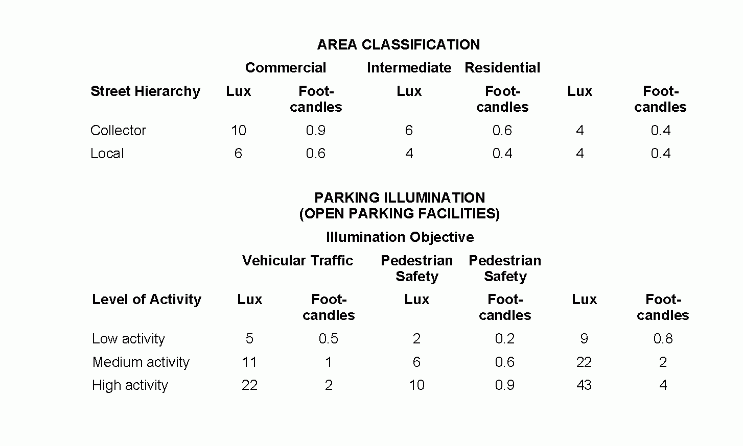
(4) The table set out below shall be used to determine the streetlighting requirements: �
(5) There shall be one streetlight at all intersections, and a streetlight at each side of the center of the arc of a roadway bend when the offset angle of the center line projections is greater than 30 degrees. �
J. Utilities. �
(1) All utilities, including, but not limited to, electric transmission, gas and water distribution, communications, streetlighting and cable television, shall be installed underground within easements or dedicated public rights-of-way. The developer shall arrange with the serving utility for the underground installation of the utility's supply lines and service connections in accordance with the prevailing standards and practices of the utility or other companies providing such service. All new building services shall be installed underground. �
(2) Water main, fire hydrant, culvert, storm sewer and sanitary sewer installations shall be properly designed and connected with an approved system and shall be adequate to handle all present and probable future development. �
K. Easements. �
(1) Easements may be required for the installation, maintenance and repair of utility lines. Such easements shall be at least 15 feet wide and shall be located in consultation with the companies or other jurisdictional agencies and, to the fullest extent possible, adjacent to lot lines. �
(2) Floodplains, drainage and conservation easements shall be indicated on the preliminary and final plats. �
(3) All easements shall be delineated and dedicated on the final plat to the Township and/or any appropriate entity. �
L. Monuments. All boundary monuments shall be the size and shape required by the Map Filing Law, N.J.S.A. 46:23-9.11, as amended, and shall be placed in accordance with the statute and indicated on the final plat. �
M. Landscape plan. A landscape plan shall be required for applications for development, except minor subdivisions, and shall be prepared in conformance with Chapter 119, Landscaping. �
N. Retaining walls. Retaining walls are discouraged for slope control, however, they may be used when no other alternatives exist and the topography dictates. For walls in excess of two feet in height, complete design plans, including all construction details, design calculations, soil borings and soil data, certified by a New Jersey licensed professional engineer, must be submitted. Retaining walls shall be constructed of treated timber or logs, reinforced concrete, reinforced masonry or of other construction which in the judgment of the Board engineer is adequately designed and detailed on the plans to carry all earth pressures, including any surcharges. The heights of retaining walls shall not exceed one-third of the horizontal distance from the foundation wall of any building to the face of the retaining wall and, as a general rule, should be limited to a difference in finished grade elevation of four feet. �
O. Grading, topsoil and seeding. All lots, open spaces and planting areas shall be graded to secure proper drainage and to prevent the collection of stormwater. The grading shall be performed in a manner which will minimize the damage to or destruction of trees growing on the land. Topsoil shall be provided and/or redistributed on the surface as cover and shall be stabilized by seeding or planting. �
(1) A grading plan, prepared by a New Jersey licensed professional engineer, shall be submitted with the application. The grading plan shall indicate the following: �
(a) Existing and proposed grading contours at intervals of one foot within a ten-foot radius of the tract, except that if slopes exceed 5%, an interval of two feet is permissible. Datum shall be referenced to United States Geological Survey Datum and the reference location of datum shall be noted. �
(b) Proposed spot or finished grade elevations at all property corners and curbs opposite property corners, first floor elevation of all proposed structures or dwellings, interior yard drainage and drainage arrows designating direction of overland drainage flow on each lot. �
(c) Property and right-of-way lines. �
(d) Grate and invert elevations of all storm inlets. �
(e) Slope, direction of flow and typical section for all streams, swales and ditches. �
(f) The tops of the banks and boundaries of the floodways and flood hazard areas of all existing watercourses, and such other information. �
(g) Determination as to what impact the proposed construction and lot regrading will have upon adjacent properties. �
(h) Methods or provisions to abate or prevent any adverse surface drainage impacts or conditions to adjacent lots. �
(2) Under no circumstances shall the subdivision tract, or any individual lots within the development, be graded in such a manner as to redirect or accelerate the velocity of flow of stormwater runoff onto adjacent and/or downstream properties. Wherever possible, the land shall be graded so that the stormwater from each lot shall drain directly to the street. If drainage toward a street is impractical, than the runoff shall be directed to an interior yard drainage system designed in accordance with this section. �
(3) Unless otherwise required by this section, all tree stumps, structural foundations and other obstructions shall be removed to a depth of two feet below existing or finished grade, whichever is lower. �
(4) Prior to the issuance of any certificate of occupancy to any dwelling, the developer or holder of the building permit shall cause to have the lot grading certified by a New Jersey licensed professional engineer that the final as-built grading of the lot is in compliance with the approved grading plan. �
(5) All lot grading plans shall conform to the following standards, and all lots shall be graded in accordance with the following requirements: �
(a) Any swale intended to convey stormwater runoff shall be specifically delineated on the grading plan. A typical swale section, profile grades and calculations indicating the capacity and flow velocity of the swale shall be provided. All swales shall be constructed in strict compliance with the following standards: �
[1] All swales shall be designed with a parabolic cross-section. �
[2] All swales shall be designed, constructed and stabilized in accordance with the requirements of the Burlington County Soil Conservation District. �
[3] Swales shall have a minimum longitudinal or profile gradient of 1% to provide a positive flow of stormwater and prevent stagnation of water in the swale. �
�
[4] No swales shall be designed in such a manner as to make a point discharge of stormwater runoff onto adjacent or downstream lands. �
[5] Swales discharging into high groundwater, bodies of water or wetlands or other environmentally sensitive areas shall have specific approval of all outside agencies having jurisdiction. �
(b) The minimum slope for lawns and disturbed areas shall be 2% and for smooth, hard finished surfaces other than roadways, 4/10 of 1%. �
(c) The minimum grade away from a house shall be 5% for a minimum distance of 10 feet. �
(d) The subdivider shall take all necessary precautions to prevent any siltation of streams during the construction of the subdivision. Such provisions may include, but are not limited to, construction and maintenance of siltation basins or holding ponds and diversion berms throughout the course of construction and planting areas. �
(e) All lots, open space and planting areas shall be seeded with a suitable stabilizing groundcover approved by the Board engineer. On open spaces, the Board may allow a suitable stabilizing groundcover other than seeding. �
(6) No topsoil shall be removed from the site or used as fill. Topsoil moved during the course of construction shall be redistributed so as to provide at least four inches of spread cover to all seeding and planting areas of the subdivision and shall be stabilized by seeding or planting. In the event that the quantity of topsoil at the site is insufficient to provide four inches of cover for all seeding and planting areas, the developer shall provide and distribute a sufficient quantity of topsoil to provide such a cover. Topsoil shall be approved by the Township Engineer. �
P. Soil erosion and sedimentation control. �
(1) All subdivisions shall incorporate soil erosion and sediment control programs, phased according to the scheduled progress of the development, including anticipated starting and completion dates. The purpose is to control soil erosion and sediment damages and related environmental damage by requiring adequate provisions for surface water retention and drainage and for the protection of exposed soil surfaces in order to promote the safety, public health, convenience and general welfare of the community. �
(2) No building permit shall be issued for any development application until all provisions of the State of New Jersey Soil Erosion and Sediment Control Act, N.J.S.A. 4:24-39 et seq., as amended, have been satisfied. �
Q. Debris. �
(1) Materials accumulated by clearing, grubbing, construction and excavation, as above described, shall be disposed of by the developer in a manner satisfactory to the Township Engineer, except that materials suitable for embankment shall be used for that purpose, if needed. Burying of the above materials shall not be permitted. �
(2) The Township Construction Code Official shall keep a constant check on debris from the development and the construction of buildings and shall not permit the accumulation thereof. In the event that there is any substantial accumulation of such debris in any development, the Construction Code Official shall forthwith give written notice to the developer to remove such debris from the development. In the event that such debris is not promptly removed, the Construction Code Official is hereby authorized and directed to refrain from giving certificates of occupancy or building permits until the debris is cleared up and removed. �
R. Drainage. �
(1) General. �
(a) The purpose of the drainage design, as outlined in this section, is to mitigate the effects of the stormwater runoff generated by the development of land. In general, the rate of stormwater runoff from the site after development should not exceed the rate occurring prior to development. The additional volume of stormwater runoff generated by the development of the site should be conveyed to an area of ultimate disposal without detriment or adverse effects to adjoining downstream properties. An area of ultimate disposal is defined for purposes of this section as a river, stream, natural body of water, drainage course or as otherwise determined and approved by the approving authority. �
(b) The design of the development shall take advantage of the natural drainage features of the land and make improvements to the natural drainage system to such an extent as is possible to eliminate flooding and excess maintenance requirements. The changing of natural drainageway locations will not be approved unless such change is shown to be without adverse effects and substantiated by thorough analysis and investigation. �
(c) Stormwater runoff from off-site drainage areas and systems that pass through the site must be accommodated by the drainage plan so that the original drainage pattern is left essentially unchanged to avoid creation of a new hazard to downstream property. When deemed necessary, drainage easements shall be established to provide for routing of the stormwater. �
(d) Storm drainage systems shall be provided for all stormwater runoff coming to or accumulating on the street and should have sufficient capacity to carry the volume of runoff as computed herein. �
(2) Drainage report. �
(a) Drainage study. �
[1] A drainage study shall be submitted which identifies drainageways, floodplains, ponding areas, locations of culverts, bridges, open channels and drainage basins which are tributary to the proposed development. �
[2] The drainage study should include a thorough analysis and discuss: �
[a] Alternate solutions to drainage problems which have been identified by the study. �
[b] The analysis of downstream and upstream drainage facilities. �
[c] The ability of the downstream drainage facilities to pass developed runoff from the proposed development. �
[d] Drainage problems which may be anticipated to occur within the development and solutions. �
[3] The discussion should be accompanied with calculations, maps, details and other supplemental information to support the assumptions, analysis and conclusions, including, but not limited to, the following: �
[a] Calculations for peak flow of all off-site tributary drainage basins. Runoff analysis shall take into consideration the future developed condition of all areas contributing runoff to the site. �
[b] Hydraulic calculations and analysis of downstream drainage facilities. �
[c] Map identifying off-site tributary drainage basins, location and size of downstream and upstream facilities, flood zones, existing topography and problem areas. �
[d] Details of critical downstream or upstream drainage structures. �
(b) Calculations and plans. �
[1] Drainage calculations shall be submitted for the analysis of predeveloped drainage areas, developed drainage areas and all proposed and existing drainage facilities. They shall include, but not be limited to, the method of determining the runoff coefficient, time of concentration and travel distance for each individual drainage basin; roughness coefficients for pipes, streams and swales; and necessary worksheets, hydrographs, charts and diagrams used for the design and analysis. �
[2] A drainage plan and details shall be submitted which includes, but is not limited to the following information: �
[a] The grading plan, as outlined in § 185-22O, shall be incorporated. �
[b] Predeveloped drainage areas numbered to correspond to the drainage calculations. �
[c] Developed drainage areas numbered to correspond to the drainage calculations. �
�
[d] Existing drainage facilities and structure and all pertinent information, such as size, shape, slope, location and inverts. �
[e] Proposed storm sewers, drainageways and easements, inlets, manholes, culverts, drainage structures and floodplains. �
[f] Proposed runoff outfall points. �
[g] Routing and accumulative flows at various critical points for stormwater runoff. �
[h] Construction details of all proposed drainage structures, including inlets, manholes, culverts, detention/retention basins, pipe and bedding and appurtenances. �
[i] Drainage facilities located in the street rights-of-way shall be shown on the street profile drawing. �
(3) Design criteria. �
(a) The method, as defined in the U.S. Department of Agriculture, Soil Conservation Service, Urban Hydrology for Small Watersheds, Technical Release No. 55, latest edition; the rational method; or other methods as approved by the Board engineer are acceptable as long as the method meets the criteria and standards set forth herein, except that the rational method shall not be used to calculate the peak rate of runoff from any areas larger than 100 acres. �
(b) The capacity and design of all storm sewer systems shall be based on a design storm of a ten-year frequency, twenty-four-hour rainfall and shall carry the peak discharge from the entire upstream watershed. �
(c) The capacity and design of culverts and open channels shall be based on runoff, as a minimum, from a design storm of a twenty-five-year frequency, twenty-four-hour rainfall or as required by any other authority having jurisdiction, and shall carry the peak discharge from the entire upstream watershed. �
(d) Where detention facilities are deemed necessary, they shall accommodate site runoff generated from two-year, ten-year and one-hundred-year storms considered individually, unless the detention basin is classified as a dam, in which case the facility must also comply with the Dam Safety Standards, N.J.A.C. 7:20. These design storms shall be defined as either a twenty-four-hour storm, using the rainfall distribution recommended by the U.S. Soil Conservation Service when using U.S. Soil Conservation Service procedures, such as U.S. Soil Conservation Service, Urban Hydrology for Small Watersheds, Technical Release No. 55, or as the estimated maximum rainfall for the estimated time of concentration of runoff at the site when using a design method such as the rational method. Runoff greater than that occurring from the one-hundred-year, twenty-four-hour storm will be passed over an emergency spillway. Detention will be provided so that after development the peak rate of flow from the site will not exceed the corresponding flow which would have been created by similar storms prior to development. For purposes of computing runoff, lands in the site shall be assumed, prior to development, to be in good condition, if the lands are pastures, lawns or parks, with good cover, if the lands are woods, or with conservation treatment, if the land is cultivated, regardless of conditions existing at the time of computation. �
(e) The capacity and design of retention and recharge facilities shall be based on a design storm of a fifty-year frequency, twenty-four-hour rainfall and provide an emergency spillway based on a design storm of a one-hundred-year frequency, twenty-four-hour rainfall. �
(f) The design criteria for the rational method for areas of 100 acres or less shall be as follows: �
[1] Formula. Computation for the rate of flow at a given location shall be based on the formula: Q = CIA, where Q = peak discharge volume in cubic feet per second; C = runoff coefficient; I = intensity of rainfall in inches per hour; and A = watershed area in acres. �
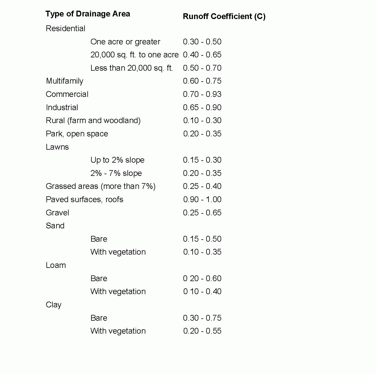
[2] Runoff coefficient (C). The values are presented for different surface characteristics as well as for different surface aggregate land uses. The coefficients for the various surface areas can be used to develop a composite value for a different land use: �
[3] Intensity (I). The average rainfall rate for the period of maximum rainfall having a duration equal to the time of concentration. The value shall be obtained from the Rainfall Intensity - Duration - Frequency curves for Trenton, New Jersey. �
[4] Time of concentration. The duration of the storm is the time required for the runoff from the most remote point of the drainage basin to reach the point being considered, length of travel, which consists of an overland flow time plus the time of travel in a storm sewer, gutter, drainageway or swale. The time of travel shall be derived from the State of New Jersey Highway Authority nomograph or as approved by the Board engineer. �
(g) Design criteria for the soil conservation method is that outlined in the U.S. Department of Agriculture Soil Conservation Service Technical Release No. 55 for Urban Hydrology for Small Water Sheds. The runoff curve numbers (CN) for predeveloped runoff shall be based on the cover type being in a good condition and the most favorable cover type found during the year. �
(4) Storm sewer design and standards. �
(a) Hydraulic calculations for storm drain pipes shall be based on Mannings formula for pipes flowing full and shall be designed to carry the maximum runoff, as stated elsewhere in these chapters. �
(b) The following coefficients for roughness shall be used in the Manning formula to determine pipe capacity: �
�
[1] Concrete pipe: N = 0.013. �
[2] Concrete pipe box culverts: N = 0.013. �
[3] For all other pipe types, use N values as specified by the manufacturer. The supporting documentation for these values should be submitted for approval by the Board engineer, or as established by the New Jersey Department of Transportation. �
(c) Storm sewer pipe grades shall be such that a minimum velocity of 2.5 feet per second will be obtained with a pipe flowing one-quarter full. �
(d) All storm sewer pipe under the road bed shall be designed for American Association of State Highway Officials H20-44 loading. All storm sewer pipe shall be of reinforced concrete pipe, Class III, Wall B strength and have a minimum cover of two feet. If the depth of cover is less than two feet, but more than one foot, Class IV reinforced concrete pipe shall be used. Alternate pipe material may be used for specific conditions as approved by the Board engineer. �
(e) Storm sewer pipe shall have a minimum inside diameter of 15 inches, with a maximum length of 50 feet. All storm sewer pipe having a length in excess of 50 feet shall have a minimum inside diameter of 18 inches. All pipe located under a roadbed shall be at least one size larger than required to carry the maximum runoff. Where pipe sizes increase, the general practice shall be to keep the inside top of the larger pipe at the same elevation as the inside top of the smaller pipe. �
(f) All transitions in slopes, horizontal direction and pipe size shall be made in a manhole, inlet or other accessible structure designed for the above purpose. �
(g) Pipe starting or terminating in an open ditch or area shall have suitable headwalls. Erosion protection shall be provided at the outfall in accordance with Soil Conservation Standards. Additionally, trash bars shall be installed on all outlet pipes equal to or greater than 24 inches in diameter. Flared end sections and other protective treatment will be considered in specific cases and subject to approval by the Board engineer. �
(h) Inlets shall be located at street intersections to intercept stormwater prior to reaching pedestrian crossings and at street low points. However, the spacing of inlets shall not exceed 400 feet or a design inlet flow of 6.0 cubic feet per second, whichever condition is more stringent. Access manholes shall be spaced at a maximum of four-hundred-foot intervals and at sewer junctions where there are no inlets. �
(i) Grease traps, oil skimmers, sediment basins and other water quality structures shall be installed in the catchbasins, as required by the Board engineer. �
(j) Inlets and catchbasins shall be designed in accordance with New Jersey State Highway Department Standard Plans and Specifications. Frames and grates shall be Campbell Foundry Company Pattern No. 2617 Bicycle Grates, or an approved equal. �
�
(k) Manholes shall be precast concrete, brick or concrete block, coated with two coats of portland cement mortar. �
(l) If precast manhole barrels and cones are used, they shall conform to ASTM Specification C-473, with round rubber gasketed joints, conforming to ASTM Specification C-923. Maximum absorption shall be 8%, in accordance with ASTM Specification C-478, method A. �
(m) If precast manholes are utilized, the top riser section shall terminate less than one foot below the finished grade and the manhole cover shall be flush with the finished grade. �
(n) Manhole frames and covers shall be of cast iron, conforming to ASTM Specification A-48 Class 30, and be suitable for H-20 loading capacity. All manhole covers in rights-of-way or in remote areas shall be provided with a locking device. The letters Year 20___ and the words STORM SEWER shall be cast integrally in the cover. �
(5) Open channels. �
(a) Open channels shall be designed in accordance with Soil Conservation Standards and provide stable soil side slopes with a maximum slope of one vertical to three horizontal. The design shall include suitable vegetative cover to prevent soil erosion. In general, velocities in open channels at design flow shall not be less than 0.05 foot per second and not greater than that velocity which will begin to cause erosion or scouring of the channel. At the transition between closed conduits and open channels or different types of open channels, suitable provisions must be made to accommodate the velocity transitions. These provisions may include rip-rapping, gabions, lining, aprons, chutes and checks or others, all suitably detailed and approved. �
(b) The following minimum coefficients of roughness values shall be used for open channels: �
[1] Concrete lined: C = 0.015. �
[2] Other values should be obtained from Soil Conservation Standards, New Jersey Department of Environmental Protection, or as otherwise approved by the Board engineer. �
(6) Detention and retention facilities. �
(a) Detention and retention facilities must be designed in accordance with the current standards of the New Jersey Department of Environmental Protection, the Soil Conservation Standards and as otherwise directed by the Board engineer. All such facilities must be designed in a manner that no adverse impact will result to lands downstream. All design proposals must be accompanied by an assessment of any impact to lands downstream and complete design details. �
(b) All detention and retention facilities for developments shall be designed using the Sod Conservation Method, as supplemented and amended. The modified rational method may be used for developments of 20 acres or less. �
�
(c) The facilities shall contain sufficient volume to contain the design storm with one foot of freeboard on all sides, except for the emergency spillway which shall be protected to prevent soil erosion. �
(d) A soil boring and percolation, or permeability, test will be required for each basin. The results shall be submitted with an estimate of the depth to seasonal high water table shown on the log. �
(e) The bottom of the basin shall be located a minimum of two feet above the seasonal high water table. The time required for a retention basin to drain after the design storm shall be provided. Detention basins shall be equipped with a low flow channel and underdrains. �
(f) Detention and retention basins shall be fully enclosed with a minimum six feet in height chain link fence, or other type of appropriate barricade as is acceptable to the Board. All basins shall also be provided with an appropriate landscaped buffer prepared in conformity with Chapter 119, Landscaping, §§ 119-9 through 119-13. �
(7) Maintenance. �
(a) All detention/retention, recharge facilities and stormwater conduits which are to be maintained by a private property owner, homeowner's association or other responsible party are required to submit a maintenance schedule for approval by the approving authority. If, in the opinion of the Township Engineer, the drainage system is not maintained, the Township shall give appropriate notice of the nature of the existing defects. Furthermore, if the party responsible for maintenance fails, within 30 days of the date of notice, to take appropriate action to rectify these defects, the Township may take necessary corrective action, the cost of which shall be charged to the responsible party and assessed against the responsible lots. �
(b) These conditions shall be set forth in a deed declaration for the responsible lots and shall run with the land. �
S. Floodplains. All land subject to flooding or located within an area designated as a flood hazard area shall be developed in conformity with the provisions of Chapter 171, Soil Removal, and Chapter 215, Zoning, Article XII, Floodplain District. �
T. Streams. Where a development is traversed by a watercourse, drainageway, channel or stream, there shall be provided a drainage easement, or right-of-way, conforming substantially with the lines of such watercourse and such further width as will be adequate for construction or maintenance purposes. �

