a. Permitted Uses. In planned residential developments, no building or structure shall be erected and no existing building or structure shall be reconstructed, moved, altered, added to or enlarged, nor shall any land or building be designed, used or intended to be used for any purpose other than as follows:�
1. Single-family detached dwellings.�
2. Townhouses and patio houses.�
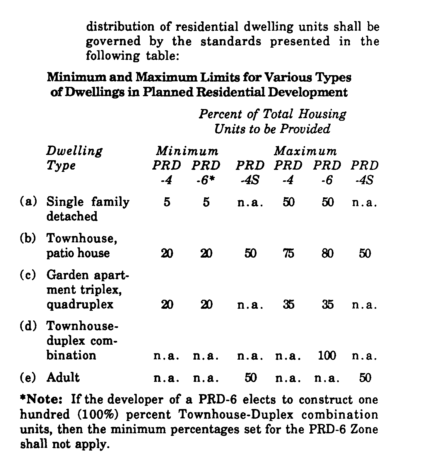
3. Townhouse-duplex combination in the PRD 6 Zone, only.�
4. Triplexes, quadruplexes, and garden apartments.�
5. Public and private educational facilities.�
6. Churches and other places of worship, including parish houses, Sunday school buildings and other similar uses.�
7. Public utilities and essential services.�
8. Parks, playgrounds, firehouses and library or Municipal buildings.�
9. Indoor and outdoor recreational facilities, including publicly and privately owned and operated golf courses and clubs, tennis courts and clubs, swimming pools and clubs, country clubs, skiing facilities, arboretums, botanical gardens, hiking trails and other similar facilities. Indoor tennis courts are excluded from this listing.�
b. Land Use Where Development Does Not Qualify as a Planned Residential Development. In areas of the PRD Zone which do not qualify as planned residential developments or do not elect to proceed as planned residential developments, all of the controls and requirements of the R-20 Residential Zone shall apply. �
**Webmasters Note: The previous sections, 24-6.9.e.1(w) through 24-6.10.b, have been amended as per Supplement No. 11.�
c. Size of Planned Residential Development.�
1. No tracts, parcels or lots or tract, parcel or lot shall be developed as a planned residential development unless it shall contain a minimum of fifty (50) or more acres of adjoining and contiguous land and shall contain sufficient access to an approved and improved street. For the purpose of this section, internal streets, roads and rights-of-way shall not be deemed to divide acreage of a planned residential development. In the PRD-4S District the total project site area shall contain a minimum of thirty-five (35) acres.�
2. The Planning Board shall have the authority to waive this requirement where:�
(a) One (1) or more parcels contain at least twenty-five (25) acres; and�
(b) The twenty-five acre site is contiguous to and abuts a planned residential development site.�
d. Buffer Areas.�
1. The landowner shall provide and maintain a buffer zone no less than one hundred (100') feet wide from all external lot lines of a planned residential development, except for that portion which fronts upon an existing external street or roadway. Such buffer zone shall be kept in its natural state where wooded; and when natural vegetation is sparse or nonexistent, the landowner may be required to provide a year-round visual screen as determined by the Planning Board. In the PRD-4S District, the landowner shall provide and maintain a buffer no less than seventy-five (75') feet wide, subject to the same requirements as noted above. Road access ways may be permitted within said PRD-4S District buffer area, provided that they be no closer than ten (10') feet from any property line and the ten (10') foot area shall be densely planted to provide maximum screening.�
**Webmasters Note: The previous sections, 24-6.8e through 24-6.10d.1, have been amended as per Supplement No. 10.�
2. The Planning Board, upon specific findings or particular circumstances relating to conditions of topography, natural features, lot configuration, natural vegetation or the lack of same, soil conditions, drainage or other similar site characteristics or where the proposed development is compatible with existing development, may decrease the required buffer area to a minimum of fifty (50') feet, or increase the required buffer area to a maximum of two hundred (200') feet.�
3. The Planning Board may modify or eliminate the requirements for a buffer area upon finding that the planned residential development abuts another planned residential development, a buffer zone designated on the zoning map of the Township or a natural or man-made barrier and that by reason thereof, the buffer area may be modified or eliminated without detriment to existing or proposed uses.�
4. No use or structure, including parking or loading areas, shall be permitted within the required buffer area, but the Planning Board may, upon a finding of reasons therefor, permit a portion of a buffer area to be used for utility easements or streets to ensure access to or from adjacent property.�
5. The required buffer area may be included in the area of a planned residential development for the purpose of computing compliance with the open space requirements of this Chapter.�
e. Area, Bulk and Yard Requirements.�
1. Boundary Line Setback Requirements. All buildings and structures shall be set back no less than thirty-five (35') feet from any external street right-of-way line or a distance equal to the height of any building or structure from the right-of-way line, whichever is greater, within a planned residential development.�
2. Area, Yard and Bulk Controls. Area, yard and bulk controls shall be in accordance with the Schedule of Area, Yard and Bulk Controls for Planned Residential Developments herein.�
3. Measurement of Setbacks. All setbacks shall be measured from the right-of-way line of the street, but if the Master Plan or Official Map of the Township shows the location of a right-of-way line different from the existing right-of-way line, the required setbacks shall be measured from the right-of-way line as shown on the Official Map, if any, or the Master Plan.�
4. At all street intersections, no obstruction to vision exceeding thirty (30") inches in height above the grade to be established at the curb, other than existing buildings, posts, columns or other trees or proposed necessary traffic control devices, shall be permitted in an area bounded by the intersecting curbline and a line joining points each thirty (30') feet distant from the intersection of the curblines along the curbline of each street.�
f. Building Height. No building or structure shall have a height greater than two and one-half (2 ) stories or thirty-five (35') feet in a planned residential development.�
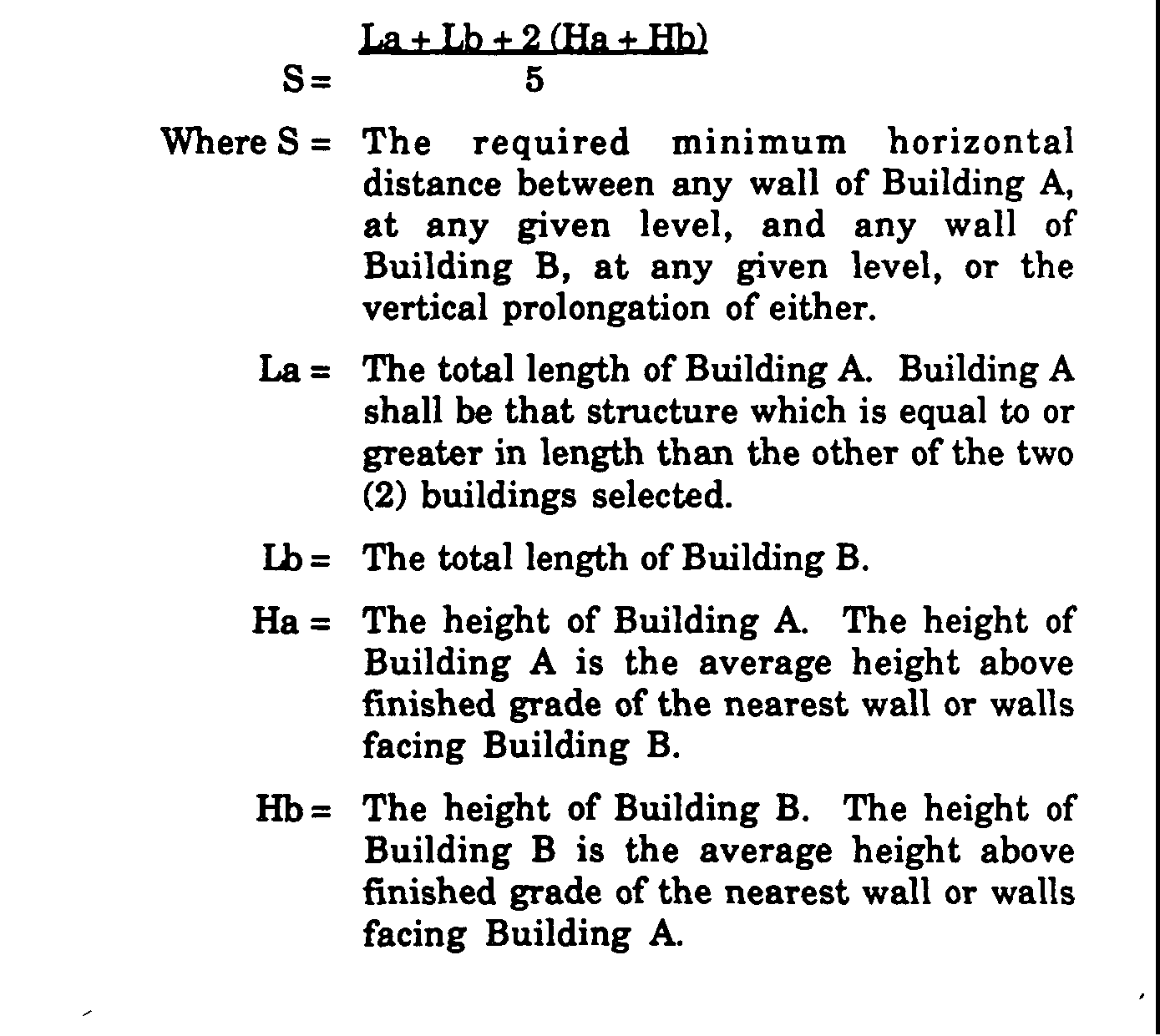
g. Distance Between Buildings. The minimum distance between any two (2) buildings, other than buildings containing common walls and used as townhouses, duplexes, etc., shall be no less than as computed under the following formula: a + Lb + 2 (Ha + lb)S= 5 Where S = The required minimum horizontal distance between any wall of Building A, at any given level, and any wall of Building B, at any given level, or the vertical prolongation of either.�

1. Overall Residential Density. Within the PRD-4 Zone, the overall residential density shall be four (4) units per acre of total land area in the planned residential development. Within the PRD-6 Zone, the overall residential density shall be six (6) units per acre of total land area in the planned residential development. For the purpose of this section, internal streets, roads and rights-of-way shall be included in the acreage calculations.�
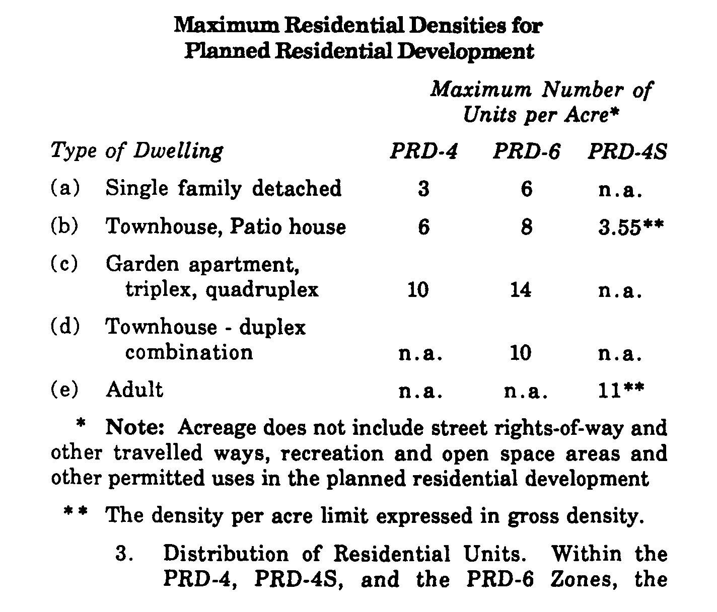
2. Net Residential Densities. The maximum net residential density in each planned residential development shall be as set forth in the following table.�
Maximum Residential Densities for Planned Residential Development�

