
�
1 Subject to obtaining permit from the Building Inspector�
2 Vegetated buffer strips means either "Filter Strips" or "Field Borders" as defined in the MADEP Nonpoint Source Management Manual, and shall be not less than 100 feet in width.�
3 NRCS Handbook available in Planning Office, Town Hall.�
4 The system of storm water management and artificial recharge of precipitation shall be designed to prevent untreated discharges to wetland and surface water; preserve hydrologic conditions that closely resemble pre-development conditions; reduce or prevent flooding by managing peak discharges and volumes of runoff; minimize erosion and sedimentation; not result in significant degradation of groundwater; reduce suspended solids and other pollutants to improve water quality; and provide increased protection of sensitive natural resources.�
These standards may be met using the following or similar best management practices:�
(a) For single or two family residences, recharge shall be attained through site design that incorporates natural drainage patterns and vegetation to maintain pre-development stormwater patterns and water quality to the greatest extent possible. Stormwater runoff from rooftops, driveways and other impervious surfaces shall be routed through vegetated water quality swales, as sheet flow over lawn areas or to constructed stormwater wetlands, sand filters, infiltration systems, organic filters and/or similar systems.�
(b) For multi-family residential and non-residential uses, a stormwater management plan shall be developed which provides for the artificial recharge of precipitation to groundwater through site design that incorporates natural drainage patterns and vegetation and uses constructed (stormwater) wetlands, wet (detention) ponds, water quality swales, sand filters, organic filters, infiltration systems, or similar site appropriate best management practices capable of removing nitrogen and other contaminants from stormwater, in compliance with the Stormwater Management Standards and technical guidance contained in the Massachusetts Department of Environmental Protection's 1997 Stormwater Management Handbook, Volumes 1 and 2. No runoff shall be discharged directly to rivers, streams, and other surface water bodies, wetlands or vernal pools.�
Except when used for roof runoff from non-galvanized roofs, all such wetlands, ponds, swales or other infiltration facilities shall be preceded by oil, grease and sediment traps or other best management practices to facilitate control of hazardous materials spills and removal of contamination and to avoid sedimentation of treatment and leaching facilities. All such artificial recharge systems shall be maintained in full working order by the owner(s) under the provisions of an operations and maintenance plan approved by the permitting authority to ensure that systems function as designed. Infiltration systems greater than three (3) feet deep shall be located at least one hundred (100) feet from drinking water wells. Any infiltration basins or trenches shall be constructed with a three (3) foot minimum separation between the bottom of the structure and maximum groundwater elevation.�
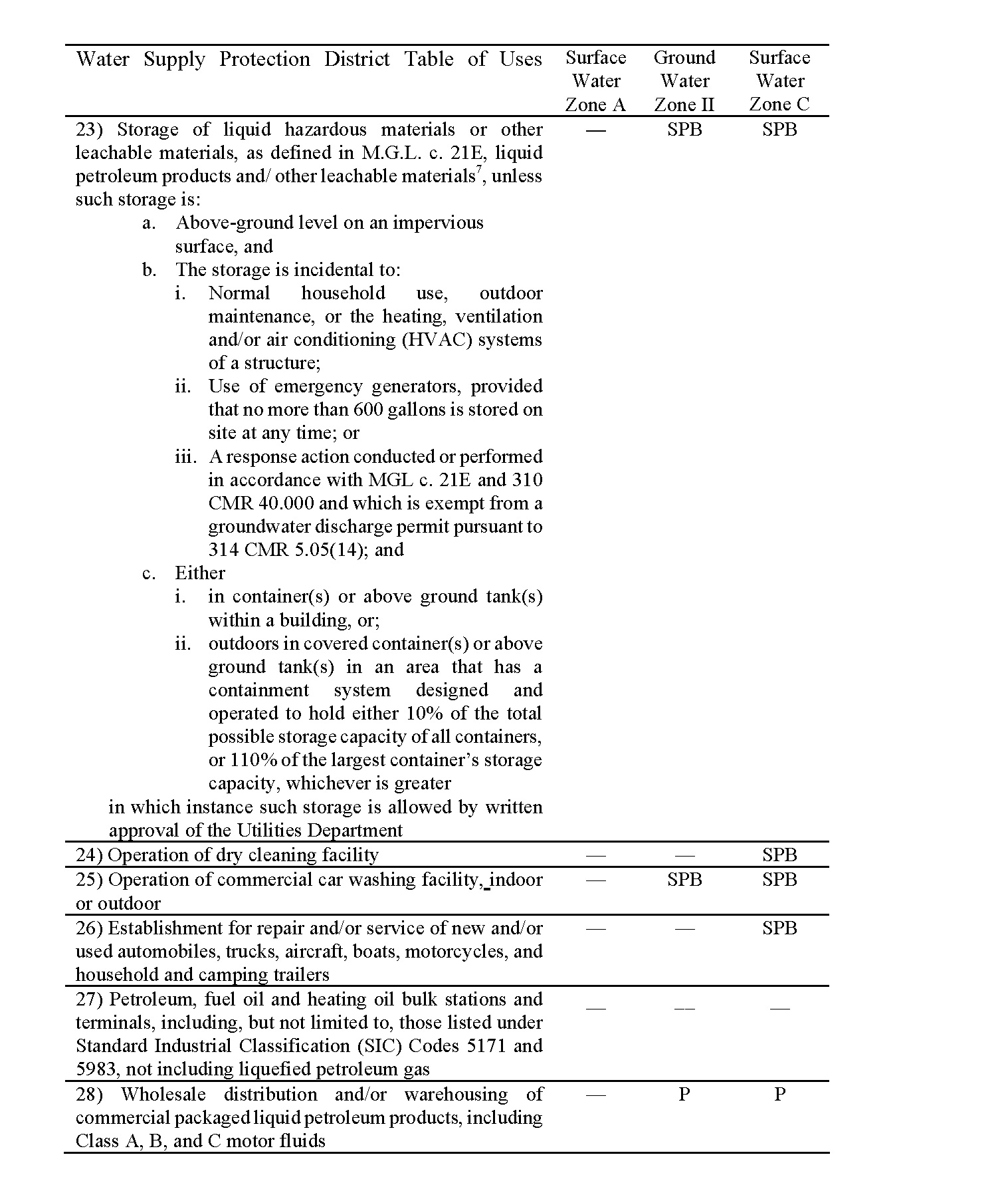
5 Not allowed in Zone A.�
6 Not allowed in Zone A unless an existing use.�
7 These storage requirements shall not apply to the replacement of existing tanks or systems for the keeping, dispensing or storing of gasoline provided the replacement is performed in accordance with applicable state and local requirements.�
8. Procedures for Issuance of Special Permit.�
a. Special Permit Granting Authority. The Special Permit Granting Authority (SPGA) under this bylaw shall be the Planning Board.�
b. Review by Other Boards and Officials. Upon receipt of the special permit application, the Planning Board shall transmit one copy each to the Board of Health, Water Commissioners, Conservation Commission, and the Department of Utilities for their written recommendations. Failure to respond in writing to the Board within 35 calendar days of receipt shall indicate approval or no desire to comment by said agency. The applicant shall furnish the necessary number of copies of the application.�
c. Criteria. The Planning Board may grant the required special permit only upon finding that the proposed use meets the criteria established in XI.J of this bylaw, as well as the following criterion:�
The proposed use shall in no way, during construction or thereafter, adversely affect the existing or potential quality or quantity of water that is available in the Water Supply Protection District; and further, the use shall be designed to avoid substantial disturbance of the soils, topography, drainage, vegetation, and other water-related natural characteristics of the site to be developed.�
d. Regulations. The Planning Board may adopt regulations to govern design features of projects. Such regulations shall be consistent with subdivision regulations adopted by the Planning Board of the Town of Ipswich.�
e. Submittal Requirements. The applicant shall file six copies of a site plan and attachments. The site plan shall be drawn at a proper scale as determined by the Planning Board and be stamped by a professional engineer. All additional submittals shall be prepared by qualified professionals. The site plan and its attachments shall at a minimum include the following information where pertinent:�
i. A complete list of chemicals, pesticides, herbicides, fertilizers, fuels, and other potentially hazardous materials to be used or stored on the premises in quantities greater than those associated with normal household use; �
ii. For those activities using or storing such hazardous materials, a Hazardous Materials Management Plan shall be prepared and filed with the Hazardous Materials Coordinator, Fire Chief, and Board of Health. The plan shall include provisions to protect against the discharge of hazardous materials or wastes to the environment due to spillage, accidental damage, corrosion, leakage, or vandalism, including spill containment and clean-up procedures.�
9. Monitoring. Periodic monitoring of existing on-site groundwater monitoring wells and/or permission to installation of new wells on the applicant's property may be required by the Planning Board as a condition of the special permit, subject to the conditions of this bylaw. Such monitoring may include sampling of wastewater disposed to on-site septic systems or cesspools, or to drywells, and sampling from groundwater monitoring wells to be located and constructed as specified in the special permit. Reports shall be submitted to the Planning Board and the Board of Health. The cost of complying with the requirements of this paragraph shall be borne by the applicant.�
10. Violations and Enforcement. Written notice of any violation of this bylaw shall be given to the responsible person as soon as possible upon observation, detection, knowledge or proof that a violation has occurred. Notice to the assessed owner of the property shall be deemed notice to the responsible person. Such notice shall specify the requirements or restriction violated and the nature of the violation, and may also identify the actions to remove or remedy the violations, preventive measures required for avoiding future violations, and a schedule of compliance. A copy of such notice shall be submitted to the Planning Board, Board of Health, the Conservation Commission, and the Department of Utilities. The cost of containment, cleanup or other action of compliance shall be borne by the assessed owner of the property.�
For situations that require remedial action to prevent impact to the water resources within the Water Supply Protection District, the Building Inspector, the Board of Health, or any of their agents may order the owner and/or operator of the premises to remedy the violations. If said owner and/or operator does not comply with said order, the Building Inspector, the Board of Health, or any of their agents, if authorized to enter upon such premises under the terms of the special permit or otherwise, may act to remedy the violation. The cost of remediation shall be the sole responsibility of the owner and/or operator of the premises.�
11. Severability. A determination that any portion or provision of this Water Resource Protection District Bylaw is invalid shall not invalidate any other portion or provision thereof, nor shall it invalidate any special permit issued previously thereunder.�
1.Purpose: The purposes of the Floodplain District are to:�
a. Ensure public safety through reducing the threats to life and personal injury;�
�
b. Eliminate new hazards to emergency response officials;�
c. Prevent the occurrence of public emergencies resulting from water quality, contamination, and pollution due to flooding;�
d. Avoid the loss of utility services, which if damaged by flooding would disrupt or shutdown the utility network and impact regions of the community beyond the site of flooding;�
e. Eliminate costs associated with the response and cleanup of flooding conditions;�
f. Reduce damage to public and private property resulting from flooding waters.�
2.Applicability�
The Floodplain District is established as an overlay district to all other zoning districts. All development in the district, including structural and non-structural activities, whether permitted by right or by special permit, must be in compliance with Chapter 13 1, Section 40 of the Massachusetts General Laws and with the following:�
Wetlands Protection Regulations, Department of Environmental Protection (DEP) (as of August 1, 1997, 3 10 CMR 10.00);�
Inland Wetlands Restriction, DEP (as of August 1, 1997, 302 CMR 6.00); Coastal Wetlands Restriction (as of August 1, 1997, 302 CMR 4.00);�
Minimum requirements for the Subsurface Disposal of Sanitary Sewage (as of August 1, 1997, 3 10 CMR 15, Title 5);�
Any variances from the provisions and requirements of the above-referenced state regulations may only be granted in accordance with the required procedures of these state regulations. (Added by 10/20/97 Special Town Meeting; approved by Attorney General 2/10/98)�
3. Development Requirements: The following additional development requirements apply in the Flood Plain District:�
a. Within Zone A, where the base flood elevation is not provided on the Town of Ipswich Compiled Flood Insurance Rate Map, the applicant shall obtain any existing base flood elevation data, and it shall be reviewed by the Building Inspector for its reasonable utilization toward meeting the elevation or flood proofing requirements, as appropriate, of the State Building Code.�
b. Located within the Flood Plain District are areas designated as coastal high hazard areas (Zone V). As these areas are extremely hazardous due to high velocity waters from tidal surges and hurricane wave wash, all new construction shall be located landward of the reach of the mean high tide.�
c. In the Floodway, designated on the Town of Ipswich Flood Boundary and Floodway Map: (Amended by 10 18/99 Special Town Meeting; approved by Attorney General 1/5/00)�
(1) All encroachments, including fill, new construction, substantial improvements to existing structures, and other developments are prohibited. If the Zoning Board of Appeals finds that any of the above will not result in any increase in flood levels during the occurrence of the 100 year flood, the Zoning Board of Appeals may allow such by special permit.�
(2) Any encroachment meeting the above standard shall comply with all flood plain requirements of the State Building Code.�
d. In the AO zones, the lowest floor of new construction of substantial improvements shall be elevated above the crown of the nearest street or above the depth number indicated on the Town of Ipswich Flood Boundary and Floodway Map. (Amended by 10/18/99 Special Town Meeting; approved by Attorney General 1/5/00)�
e. Incorporated herein by reference are the following: The Flood Insurance Study, Town of Ipswich, Massachusetts, prepared by the Federal Emergency Management Agency, February 5, 1985, on file in the office of the Town Clerk; the Flood Insurance Rate Maps, dated August 5, 1985, and revised July 2, 1992, and the Flood Boundary and Floodway maps, dated August 5, 1985, on file in the office of the Department of Planning & Development. (Added by 10/18/99 Special Town Meeting; approved by Attorney General 1/5/00)�
f. In Zone A, A1-A30, and AE, along watercourses that have not had a regulatory floodway designated, the best available Federal, State, local, or other floodway data shall be used to prohibit encroachments in floodways which would result in any increase in flood levels within Ipswich during the occurrence of the base flood discharge. (Added by 10/18/99 Special Town Meeting; approved by Attorney General 1/5/00)�
g. Base flood elevation data is required for subdivision proposals or other developments greater than 50 lots or five acres, whichever is the lesser, within unnumbered A zones. (Added by 10/18/99 Special Town Meeting; approved by Attorney General 1/5/00)�
h. Within Zones AH and AO on the Flood Insurance Rate Map (FIRM), adequate drainage paths around structures on slopes will be required to guide floodwaters around and away from proposed structures. (Added by 10/18/99 Special Town Meeting; approved by Attorney General 1/5/00)�
i. Man-made alteration of sand dunes within Zones V1-V30, VE, and V which would increase potential flood damage is expressly prohibited. (Added by 10/18/99 Special Town Meeting; approved by Attorney General 1/5/00)�
j. All subdivision proposals, regardless of zone, will be reviewed to assure that: a) such proposals minimize flood damage; b) all public utilities and facilities are located and constructed to minimize or eliminate flood damage; and c) adequate drainage is provided to reduce exposure to flood hazards. (Added by 10/18/99 Special Town Meeting; approved by Attorney General 1/5/00)�
4.Notification Requirements: In a riverine situation, the Ipswich Department of Planning and Development shall notify the following of any alteration or relocation of a watercourse:�
a. Communities of Essex, Gloucester, Topsfield, Boxford, Rowley, and Hamilton�
b. NFIP State Coordinator�
Massachusetts Office of Water Resources �
100 Cambridge Street�
Boston, MA 02202�
c. NFIP Program Specialist�
FEMA Region I, Room 462�
J.W. McCormack Post Office & Courthouse �
Boston, MA 02109�
(Section 4. added by 10/18/99 Special Town Meeting; approved by Attorney General 1/5/00)�
1.Purpose�
The purposes of providing access to no more than two residential lots over a common driveway, rather than by individual driveways on each lot, are:�
a. to enhance public safety by reducing the number and frequency of points at which vehicles may enter upon the ways used by the public, particularly arterial streets as defined in the Rules and Regulations Governing the Subdivision of Land in Ipswich, Massachusetts;�
b. to preserve, protect and enhance environmentally sensitive land, such as well recharge areas, wetlands and flood plains, by reducing the area of land that is cleared, excavated, filled and/or covered with impervious surface;�
c. to encourage the protection and preservation of significant natural features and vistas.�
2.Applicability and Requirements�
Common driveways serving no more than two lots, each with approved frontage on a public way, are allowed as-of-right provided they meet the following requirements:�
a. The common driveway shall not be in excess of five hundred (500) feet in length.�
b. The common driveway shall not enter any roadway at a point separated by less than one hundred (100) feet from an intersection. On a state-numbered highway, the common driveway shall not enter the roadway at a point separated by less than one hundred (100) feet from any other driveway, curb cut, or intersection.�
c. The common driveway shall not be allowed if it would serve as the primary means of access to property which is publicly controlled or which serves a public purpose.�
d. Permanent signs indicating the street number address assigned to each lot served by the common driveway shall be installed within ten (10) feet of the intersection of the common driveway with the street, as well as within ten (10) feet of the intersection of an individual lot driveway with the common driveway.�
e. The common driveway shall access the property over the frontage of either or both of the lots being served by the driveway.�
f. The owners of the properties to be served by the common driveway must provide evidence to the Building Inspector that they have rights, either by deed or perpetual easement, to the common driveway.�
g. The common driveway shall be no less than twelve (12) feet in width and shall be treated with an all-weather surface. The width requirement shall apply only to that portion of a driveway which is used in common by more than one (1) lot. (Added by 4/07/97 Annual Town Meeting; approved by Attorney General 7/02/97)�
(Added by October 21, 1996 Special Town Meeting and approved by the Attorney General December 9, 1996)�
1.Purpose and Intent�
It has been documented in numerous other towns and cities throughout the Commonwealth of Massachusetts and elsewhere in the United States that Adult Entertainment Establishments are distinguishable from other business uses and that the location of adult entertainment uses degrades the quality of life in the areas of a community where they are located. Studies have shown secondary impacts such as increased levels of crime and blight resulting from the clustering and concentration of Adult Entertainment uses. Late night noise and traffic also increase due to the late hours of operation of many of these Establishments. This subsection is enacted pursuant to MGL Chapter 40A, Section 9 and the Home Rule Amendment to the Massachusetts Constitution with the purpose and intent of regulating and limiting the location of Adult Entertainment Establishments (as defined herein) so as to prevent the secondary effects associated with these establishments, and to protect the health, safety, and general welfare of the present and future inhabitants of the Town of Ipswich.�
The provisions of this subsection have neither the purpose nor effect of imposing a limitation or restriction on the content of any communicative matter or materials, including sexually oriented matter or materials. Similarly, it is not the intent or effect of this subsection to restrict or deny access by adults to sexually oriented matter or materials protected by the Constitution of the United States or of the Commonwealth of Massachusetts, nor restrict nor deny rights that distributors or exhibitors of such matter or materials may have to sell, distribute, or exhibit such matter or materials. Neither is it the intent or effect of this subsection to legalize the distribution of obscene matter or materials.�
2. Applicability�
This subsection applies to all Adult Entertainment Establishments, as defined in Section 9A of MGL Ch. 40A.�
3. Regulations and Standards�
No special permit may be granted by the Planning Board for any Adult Entertainment Establishment unless the following conditions are satisfied:�
a. Adult Entertainment Establishments shall not be located less than 300 feet from the nearest property line of residentially-zoned property nor less than 500 feet from the nearest property line of:�
(1) Another Adult Entertainment Establishment�
(2) Public or Private Nursery School, Day Care Center, or Kindergarten�
(3) Public or Private Elementary Schools or Secondary Schools�
(4) Playgrounds�
(5) Churches or other religious facilities�
(6) Library�
(7)Any establishment licensed under the provisions of Section 12 of MGL, Ch. 13 8.�
b. All building openings, entries and windows shall be screened in such a manner as to prevent visual access of the public to the interior of the Establishment.�
c. All parking areas for Adult Entertainment Establishments shall be in the side or front yards and shall conform to the requirements of Section VII. of this bylaw. All parking areas shall be illuminated and all lighting shall be contained on the Establishment's property. The number of parking spaces required for Adult Entertainment Establishments shall be based on the nature of the use, and shall conform to the requirements set forth in the Table of Minimum Parking Requirements for such use.�
d. The proposed use and all associated advertising signs shall not be located within fifty (50) feet of a public or private way and must be set back a minimum of fifty (50) linear feet from all property lines.�
e. The application for a Special Permit for an Adult Entertainment Establishment under this subsection must include the following information:�
(1) Name and address of the legal owner of the Establishment�
(2) The number of employees�
(3) Proposed security precautions�
(4) The physical layout of the premises (5) Nature of the business�
f. Signs for adult use establishments must be non-illuminated and otherwise conform to the requirements of Section VIII. of this bylaw.�
g. No special permit shall be issued to any person convicted of violating the provisions of Section 63 of MGL Ch. 119 or Section 28 of MGL Ch. 272.�

